Note: Descriptions are shown in the official language in which they were submitted.
CA 02754067 2011-08-31
WO 2010/104724 PCT/US2010/026147
METHOD FOR INTEGRATING RESERVOIR CHARGE
MODELING AND DOWNHOLE FLUID ANALYSIS
Cross-reference to related applications
Not applicable.
Statement regarding federally sponsored research or development
Not applicable.
Background of the Invention
Field of the Invention
[0001] The invention relates generally to the fields of hydrocarbon
exploration,
sedimentary basin simulation, subsurface hydrocarbon reservoir charge
modeling,
geological modeling, subsurface rock formation petrophysical properties
evaluation and
downhole fluid analysis. More specifically, the invention relates to
techniques for
integrating a plurality of different types of measurements of subsurface rock
formations
and related interpretation methods to evaluate probable spatial distribution
and variations
thereof of hydrocarbons within a sedimentary basin. A purpose for such
evaluation is to
reduce uncertainty during the exploration and appraisal of oil and gas
reservoirs.
Background Art
[0002] A geologic sedimentary basin is a depression in the surface of the
Earth's crust
that undergoes infilling with sediment deposits. Such sediments are typically
derived
from weathered rock formations, from biogenic activity, from precipitation of
minerals
from solution and combinations of the foregoing. When deposited sediments are
buried,
they are subjected to increasing pressure and temperature. Such burial and
subjecting to
elevated pressure and temperature begin the process of lithification
(conversion of
unconsolidated sediments into rock formations).
1
CA 02754067 2011-08-31
WO 2010/104724 PCT/US2010/026147
[0003] Petroleum (i.e., oil and gas) may be formed within a basin by chemical
reactions
of sedimentary biogenic precursor material. After generation, petroleum is
spatially
distributed within the basin via permeable pathways until it accumulates
within porous
and permeable reservoir rock formations or it is dissipated by chemical or
biochemical
reactions, or leakage to the surface of the basin. Within any particular
basin, there may
be one or more "plays" for possible production of hydrocarbons. The U.S.
Geological
Survey defines a "play" as "a set of discovered or undiscovered oil and gas
accumulations or prospects that exhibit nearly identical geological
characteristics such as
trapping style, type of reservoir and nature of the seal". An accumulation may
consist of
several different reservoirs which differ from each other by the nature of the
fluids within
the pore spaces of the rock formations and/or the pressure thereof. Finally, a
"reservoir"
is defined as a rock formation with substantially uniform rock mineral
properties and
spatial distribution of permeability such that the rock formation has the
capability to store
fluids, and has the capability for fluids to be moved therethrough by
application of
suitable pressure variations.
[0004] Basin modeling is a technique that provides for reconstruction of
geological
processes that may have occurred in sedimentary basins over geological times,
and more
specifically the events leading to generation, migration and accumulation of
hydrocarbons in reservoir rocks. Important inputs to basin modeling are the
"charge"
(source rock fractional hydrocarbon precursor content, source rock thickness,
and
hydrocarbon maturity), and the trap (the basin geometry, reservoir and seal
qualities) of a
prospect or play. The thermal, pressure and hydrocarbon generation and
migration
history are also modeled to make predictions of current hydrocarbon quality
and spatial
distribution within the basin. The description of petroleum fluids in basin
modeling is
primarily determined by the processes of generation and expulsion that govern
the overall
composition of the fluids, and the pressure, volume and temperature ("PVT")
behavior
responsible for the distribution of components in each fluid phase during
secondary
migration and accumulation in a reservoir. The charge history of an
accumulation or an
individual reservoir can be tracked in compositional form according to
selected
compound classes, for example, C02, H2S, methane, C2-5, C6-15, C16+.
Thermodynamic
2
CA 02754067 2011-08-31
WO 2010/104724 PCT/US2010/026147
models known as equations of state, e.g., SRK and Peng-Robinson, can be used
to make
phase property predictions such as gas-oil ratio (GOR), fluid density and/or
fluid
viscosity. Post-accumulation alteration processes such as biodegradation,
water washing,
and oil-to-gas cracking can also be simulated. Source rock tracking, the
evolution of the
composition through time, yields and compositions of the products generated
and
released can also be modeled. These simulations can be performed using a
commercially
available basin simulation software package, for example, one sold under the
trademark
PETROMOD, which is a registered trademark of Western Geco, LLC, 10001 Richmond
Avenue, Houston, TX 77042. The foregoing software has the capability for the
user to
modify fluid data to calibrate the fluid model. Hydrocarbons are described in
the basin
simulation software using a limited number of components, e.g. up to 14
components. It
is also customary to lump several components into one or more pseudo
components (e.g.
C2-C6, C 15+) to reduce computation time.
[0005] The present day hydrocarbon composition depends chiefly on the quality
of the
precursor organic matter (the kerogen) and the processes of petroleum
generation within
the source rock. The controlling mechanisms for the formation of the
hydrocarbons are
the petroleum generation potential of the source rock, determined by the total
organic
(non carbonate) carbon (TOC) and the hydrogen index (HI), and the burial
history,
which determines the temperature history, and that regulates the multitude of
chemical
reactions that take place over geologic time to transform the kerogen into
petroleum
components. For example, one means of describing the petroleum generation
process is
by Arrhenius type reaction schemes. In such case, the model parameters are the
Activation Energy, which describes the required threshold energy required to
initiate the
reaction, and the Frequency Factor (also known as pre-exponential factor),
which
represents the frequency at which the molecules will be transformed. Since
many
reactions take place, there could be several activation energy and frequency
factor values.
It is common practice to consider the frequency factor as constant due to its
weaker
dependence on temperature, and to represent the activation energy by means of
a discrete
probability distribution. The corresponding frequency factors and activation
energies can
roughly be determined by the organofacies, i.e. an empirical description of
the type of the
3
CA 02754067 2011-08-31
WO 2010/104724 PCT/US2010/026147
precursor material, concentration, depositional processes, and its relation to
present day
hydrocarbon composition. Hydrocarbon generation models are based on the
analysis of
source rock samples or on suitable geological assumptions about the history of
a
sedimentary basin. Such models consist of a distribution of organofacies, with
appropriate frequency factors and activation energies. and the amount of
precursor
material, which is usually specified by means of TOC and HI maps.
[0006] The spatial extent covered by typical basin models is larger than for
reservoir
simulation models. Therefore, the spatial resolution of basin models is
typically lower
than that required for reservoir simulation. Some post-migration processes
that affect the
quality of the hydrocarbon, such as biodegradation and water washing, are
better modeled
at the basin scale; however, another important process that occurs at the
reservoir scale
and that affects the production of hydrocarbons from any particular reservoir
is the
mixing of hydrocarbon species. Typically the nature of the hydrocarbons
generated in
the source rock varies with time, a result of the burial and thermal history
of the basin.
Longer chain hydrocarbons (heavy components) are expelled first followed by
shorter
chain hydrocarbons (lighter components). It has been common practice in basin
modeling to presume that fluid composition is homogenous throughout the
accumulation,
i.e., the chemical components are well mixed throughout the hydrocarbon
column.
However, in addition to biodegradation and temperature gradients, variations
in fluid
composition within an accumulation can be a result of the charge history and
could even
reflect active charging. See, for example, Mullins, O.C., Elshahawi, H.,
Stainforth, J.G.,
Integration of Basin Modeling Considerations with Wireline Logging, SPWLA 49th
Annual Logging Symposium, Edinburgh, Scotland, May 25-28, 2008 and J.G.
Stainforth,
New Insights into Reservoir Filling and Mixing Processes in J.M. Cubit, W.A.
England,
S. Larter, (Eds.) Understanding Petroleum Reservoirs: toward and Integrated
Reservoir
Engineering and Geochemical Approach, Geological Society, London, Special
Publication, (2004).
[0007] It is important to translate the present distribution of hydrocarbons
in an
accumulation to relevant parameters in the basin model that will help reduce
uncertainty
as to the spatial distribution of hydrocarbon species. Fluid properties are
one of the key
4
CA 02754067 2011-08-31
WO 2010/104724 PCT/US2010/026147
elements of basin modeling since they are a direct consequence of the series
of events
that took place over geologic time from the origin of the hydrocarbon. One way
to
determine fluid properties is by lowering a sample taking instrument into a
wellbore
drilled through the relevant rock formations and withdrawing a sample of the
fluid from
the rock formation under particular conditions. The foregoing technique
enables the
acquisition of fluid samples very close to the native reservoir pressure and
temperature,
therefore maximizing the likelihood that the samples are representative of the
fluid
existing in the particular reservoir. Furthermore, some analyses of the fluid
in subsurface
formations can be performed as it enters the sample taking instrument,
minimizing the
risk of sample fouling and providing a device for identifying the fluid that
can be used for
tracking the sample during subsequent analyses in the laboratory. Certain
fluid features
such as H2S, C02, and asphaltene content are preferably determined in the
downhole to
avoid irreversible transitions during the sample transportation to the
laboratory that lead
to inaccurate measurements. Samples can be taken by such instruments at
several depths
along the wellbore, therefore the foregoing technique can provide the level of
spatial
resolution required to resolve fluid composition variations at the reservoir
scale.
Methods used for the analysis of reservoir fluids in the wellbore include
visible-near-
infrared absorption spectroscopy, gas chromatography, mass spectroscopy,
nuclear
magnetic resonance (NMR), and other sensors, to determine composition (e.g.
fractional
amounts of C02, H2S, C1, C2, C3, C4, C5, C6, etc.), gas-oil ratio,
distribution of
hydrocarbon fractions based on carbon number and compound classes (saturates,
aromatics, resins, paraffins, naphtenes, and asphaltenes), fluid density,
fluid viscosity,
saturation pressure, and identification of certain biomarkers. Density and
viscosity of
fluid samples may be measured in the downhole sampling tool at different
pressures to
obtain a better characterization of the PVT behavior of the fluid. The
foregoing technique
also enables reliable assessment of asphaltene content in petroleum. Another
technique
based on nuclear magnetic resonance enables an analysis of the fluids within
the rock to
estimate distribution of hydrocarbon fractions based on carbon number, gas-oil
ratio, and
relative ratios of hydrocarbon compound classes. Combination of both in situ
analysis
and analysis of the fluid as it is withdrawn into the sample taking instrument
allows a
CA 02754067 2011-08-31
WO 2010/104724 PCT/US2010/026147
more complete characterization of the fluid and provides immediate results
that can be
used to optimize the data acquisition process while the sampling tool is still
in the well.
The fluid properties that can be determined by the foregoing analyses are
consistent with
the level of detail of the fluid information required for basin simulation.
[0008] High-resolution laboratory measurements provide additional details on
the
chemistry of the downhole fluid samples also relevant for basin modeling. Such
techniques include high field 13C and 1H nuclear magnetic resonance, high
resolution
mass spectroscopy, two-dimensional gas chromatography (GCxGC), sulfur X-ray
absorption near edge structure (XANES) and carbon X-ray Raman spectroscopy.
The
results obtained with these techniques may be combined with the downhole fluid
analyses
for probing further on the nature of the fluids, comparing samples
(compositional
variations), identifying sample source, identifying post-migration processes
like water
washing and biodegradation, and analyzing the heavy fraction of crude oil,
which bears
the most chemical resemblance with the kerogen that produced the present-day
hydrocarbon. Prior to these laboratory analyses, downhole fluid samples should
be
subject to a chain of custody procedure, consisting of reconditioning the
sample to the
same conditions of pressure and temperature prevailing during the acquisition
of the
sample in the downhole, analysis of a subset of the fluid sample using the
same
techniques employed in the downhole environment, and comparison of the
laboratory and
downhole results to determine the quality of the sample, i.e. preservation of
the chemical
composition.
[0009] Downhole fluid analyses (DFA) as fluids are withdrawn from a reservoir
using
VIS-NIR spectroscopy, NMR, gas chromatography and other sensors, in situ fluid
analyses with NMR, and pressure and temperature gradient measurements can
provide
the following information: (a) fluid composition, compound classes (saturates,
aromatics,
resins, asphaltenes, paraffins, naphtenes), density, viscosity, (b) fluid
composition and
pressure variations between stratigraphic units. This provides information on
the level of
compartmentalization of the accumulation; (c) fluid composition variations
within the
same layer. Fluid composition variations could be observed within the same
layer in
thick intervals and when drilling along a reservoir (geo-steered wells).
Special chemical
6
CA 02754067 2011-08-31
WO 2010/104724 PCT/US2010/026147
analysis in the laboratory can provide more detailed information on the nature
of the
hydrocarbons: (a) principal chemical classes present in the sample; (b) gas
isotopes (c)
presence of heavy metals, etc. Analysis of the chemistry of larger molecules
(the heavy
fraction of crude oil) can provide information concerning: (a) similarity
between fluids
analyzed at different spatial locations; (b) chemical composition of the
precursor material
(kerogen)
[0010] All the foregoing provide information on the level of mixing of
hydrocarbon
species within an accumulation, on the possible origin of the hydrocarbons, on
the level
of hydrocarbon maturation, and whether the hydrocarbon has been subject to
biodegradation or water washing, all of which are important components of
basin
modeling.
[0011] Fluid analysis in the reservoir and laboratory analyses have been used
in reservoir
exploration/appraisal to help determine the reservoir structure. Fluid
pressure data are
used to assess the areal and vertical continuity of specific reservoir units.
A fluid model
that uses the fluid features observed as input can be combined with the
geological model
of the reservoir. Since field appraisal and development can occur at a faster
pace than
exploration, it is desirable to be able to predict fluid properties at the
locations of
wellbores expected to be drilled to facilitate real time analysis and
continuous update of
the geological model.
Summary of the Invention
[0012] A method according to one aspect of the invention for estimating
properties of
fluids in rock formations at selected geodetic locations within a geologic
basin includes
generating an initial model of the geologic basin. The model includes as
output spatial
distribution of at least rock formation mineral composition, rock formation
porosity and
composition of fluids in the rock formation porosity. An initial estimate of
fluid
composition is generated for at least one rock formation at at least one
selected location
within the basin. A sample of fluid is extracted from pore spaces of the at
least one rock
formation from within a wellbore drilled therethrough. Composition of the
fluid sample
is analyzed from within the wellbore. The initial model of the basin is
adjusted such that
7
CA 02754067 2011-08-31
WO 2010/104724 PCT/US2010/026147
model predictions substantially match the analyzed fluid composition. The
adjusted
model is used to generate an initial estimate of fluid composition at at least
one additional
geodetic location within the basin.
[0013] Other aspects and advantages of the invention will be apparent from the
following
description and the appended claims.
Brief Description of the Drawings
[0014] FIG. IA shows an example wellbore drilling system which includes a
fluid
sample taking instrument.
[0015] FIG. lB shows an example wireline instrument for taking formation fluid
samples.
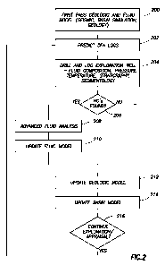
[0016] FIG. 2 is a flow chart of one example of a method according to the
invention.
Detailed Description
[0017] FIG. IA illustrates a wellsite system including a formation fluid
sample taking
apparatus. The wellsite can be onshore or offshore. In this example system, a
wellbore
311 is drilled through subsurface formations by rotary drilling in a manner
that is well
known in the art. Other example of the invention can be used in connection
with
directional drilling apparatus and methods.
[0018] A drill string 312 is suspended within the wellbore 311 and includes a
bottom
hole assembly ("BHA") 300 proximate the lower end thereof. The BHA 300
includes a
drill bit 305 at its lower end. The surface portion of the wellsite system
includes platform
and derrick assembly 310 positioned over the wellbore 311, the assembly 310
including a
rotary table 316, kelly 317, hook 318 and rotary swivel 319. The drill string
312 is
rotated by the rotary table 316, which is itself operated by well known means
not shown
in the drawing. The rotary table 316 engages the kelly 317 at the upper end of
the drill
string 312. The drill string 312 is suspended from the hook 318. The hook 318
is attached
to a traveling block (also not shown), through the kelly 317 and the rotary
swivel 319
which permits rotation of the drill string 312 relative to the hook 318. As is
well known,
8
CA 02754067 2011-08-31
WO 2010/104724 PCT/US2010/026147
a top drive system (not shown) could alternatively be used instead of the
kelly 317 and
rotary table 316 to rotate the drill string 312 from the surface.
[0019] In the present example, the surface system further includes drilling
fluid ("mud")
326 stored in a tank or pit 327 formed at the wellsite. A pump 329 delivers
the drilling
fluid 326 to the interior of the drill string 312 via a port in the swivel
319, causing the
drilling fluid 326 to flow downwardly through the drill string 312 as
indicated by the
directional arrow 308. The drilling fluid 326 exits the drill string 312 via
water courses,
or nozzles ("jets") in the drill bit 305, and then circulates upwardly through
the annulus
region between the outside of the drill string and the wall of the borehole,
as indicated by
the directional arrows 309. In this well known manner, the drilling fluid 326
lubricates
the drill bit 305 and carries formation cuttings up to the surface, whereupon
the drilling
fluid 326 is cleaned and returned to the pit 327 for recirculation.
[0020] The bottom hole assembly 300 of the illustrated example can include a
logging-
while-drilling (LWD) module 320, a measuring-while-drilling (MWD) module 330,
a
roto-steerable directional drilling system and hydraulically operated motor,
and the drill
bit 305.
[0021] The LWD module 320 is housed in a special type of drill collar, as is
known in
the art, and can contain one or a plurality of known types of well logging
instruments. It
will also be understood that more than one LWD and/or MWD module can be
employed,
e.g. as represented at 320A. (References, throughout, to a module at the
position of LWD
module 320 can alternatively mean a module at the position of MWD module 320A
as
well.) The LWD module 320A typically includes capabilities for measuring,
processing,
and storing information, as well as for communicating with the surface
equipment. In the
present embodiment, the LWD module 320 includes a fluid sampling device as
will be
further explained below.
[0022] The MWD module 330 is also housed in a special type of drill collar, as
is known
in the art, and can contain one or more devices for measuring characteristics
of the drill
string and drill bit. The MWD module 330 further includes an apparatus (not
shown) for
generating electrical power for the downhole portion of the wellsite system.
Such
9
CA 02754067 2011-08-31
WO 2010/104724 PCT/US2010/026147
apparatus typically includes a turbine generator powered by the flow of the
drilling fluid
326, it being understood that other power and/or battery systems may be used
while
remaining within the scope of the present invention. In the present example,
the MWD
330 module can include one or more of the following types of measuring
devices: a
weight-on-bit measuring device, a torque measuring device, a vibration
measuring
device, a shock measuring device, a stick slip measuring device, a direction
measuring
device, and an inclination measuring device.
[0023] FIG. lB is a simplified diagram of a sampling-while-drilling device,
and may be
of a type described, for example, in U. S. Patent Application Publication No.
2008/0156486, incorporated herein by reference. The sampling while drilling
logging
device may be utilized as the LWD tool (320 in FIG. IA) or part of an LWD tool
suite.
The LWD tool (320 in FIG. IA) is provided with a probe 406 for establishing
fluid
communication with the formation and drawing the formation fluid 421 into the
tool, as
indicated by the arrows. The probe 406 may be positioned in a stabilizer blade
423 of the
LWD tool (320 in FIG. IA) and extended therefrom to engage the wellbore wall.
The
stabilizer blade 423 comprises one or more blades that are in contact with the
wellbore
wall. Fluid drawn into the downhole tool using the probe 406 may be measured
to
determine, for example, pretest and/or pressure, an/or formation temperature
parameters.
Additionally, the LWD tool 320 may be provided with devices, such as sample
chambers,
for collecting fluid samples for retrieval at the surface. Backup pistons 481
may also be
provided to assist in applying force to push the drilling tool and/or probe
against the
wellbore wall.
[0024] It is also possible to use the sample taking instrument illustrated in
FIG. lB at the
end of an armored electrical cable ("wireline"). Accordingly, the manner of
conveyance
of the sample taking instrument is not a limit on the scope of the present
invention. Other
examples of wireline conveyed fluid sample taking instruments include one
identified by
the trademark MDT - MODULAR FORMATION DYNAMICS TESTER, which is a
trademark of the assignee of the present invention. A description of the
foregoing
instrument may be viewed at the Uniform Resource Locator
http://www.slb.com/media/services/evaluation/reservoir/mdt.pdf.
CA 02754067 2011-08-31
WO 2010/104724 PCT/US2010/026147
[0025] In one example the sample taking instrument (e.g., LWD tool 320 in FIG.
IA or
the MDT instrument identified above) may include a fluid analysis module known
by the
trademark CFA ("Composition Fluid Analyzer"), which is a trademark of the
assignee of
the present invention. In such module near-infrared optical absorption
spectrometry and
fluorescence emission measurements are used to determine gas-fraction
concentrations
and to identify fluid types, respectively, as fluids flow through the CFA
module. Another
example of a fluid sample taking and fluid analysis instrument that may be
used in some
examples is known by the trademark INSITU FLUID ANALYZER, which is a trademark
of the assignee of the present invention. The foregoing instrument includes
dual near
infrared optical absorption spectrometers, a filter array spectrometer for
determination of
CO2 content, a fluid color analyzer, and various other fluid sensors,
including resistivity,
density, pressure, temperature and fluorescence. Other measurements that may
be used
to analyze the fluid samples include NMR, which may be made using an
instrument
identified by one of the following trademarks: MR Scanner, proVISION and CMR,
all of
which are trademarks of the assignee of the present invention. It is also
within the scope
of the present invention to analyze the fluid samples using gas or liquid
chromatography,
nuclear magnetic resonance measurement, mass spectroscopy, performing PVT
experiments within the sample taking instrument, visible-near infrared optical
absorption
spectroscopy, density measurement, viscosity measurement, hydrogen sulfide
concentration measurement, and measurement of variations of density by a
controlled
depressurization in the sample taking instrument.
[0026] In a method according to the invention, downhole fluid analysis ("DFA")
may be
performed using measurements made by formation fluid sample taking instruments
such
as explained above. Referring to FIG. 2, in an example method, at 200, an
initial model
of a geologic basin may be generated. Such model may use as input any
available
seismic data, and any available data on rock composition, sources of sediment
and other
geologic information. A model may be generated using, for example, the
computer
software described in the Background section herein, namely, software sold
under the
trademark PETROMOD, which is a registered trademark of Western Geco, LLC,
10001
Richmond Avenue, Houston, TX 77042. The foregoing software, also has explained
in
11
CA 02754067 2011-08-31
WO 2010/104724 PCT/US2010/026147
the Background section herein, has the capability for the user to modify fluid
properties
data to calibrate the fluid model. The initial model includes as output the
expected spatial
distribution of rock formation type (e.g., mineral composition), rock
formation fractional
volume of pore space ("porosity"), pore pressure and temperature, and fluid
content
within the pore spaces of the rock formations. At 202, the fluid model portion
of the
basin model may be used to predict what the response of DFA will be in any
particular
geodetic location within the modeled basin. Typically, but not exclusively,
such
predicted DFA response will be for a geodetic location that corresponds to an
intended
geodetic location of a wellbore that will be drilled in the modeled basin. At
204, the
wellbore is drilled. Such drilling may, for example, be performed using a
wellsite system
such as shown in and explained above with reference to FIG. IA. Wellbore fluid
may be
extracted using a sample taking instrument, for example, as explained above
with
reference to FIG. IA and/or FIG. lB. Other measurements made by various well
logging
instruments inserted into the wellbore (either during drilling or thereafter)
may include,
without limitation, electrical resistivity, compressional and shear acoustic
velocity,
naturally occurring gamma radiation, gamma-gamma Compton scatter formation
density,
formation neutron hydrogen index (related to the fluid filled fractional
volume of pore
space of the rock formations), nuclear magnetic resonance transverse and
longitudinal
relaxation time distribution and diffusion constant, and
pressure/volume/temperature
(PVT) behavior of samples of fluid withdrawn from the formations. Such PVT
behavior
may include static reservoir fluid pressure, fluid viscosity and its
relationship to
temperature and pressure. Geologic information, such as rock mineral
composition may
be inferred from measurements such as the above-cited gamma radiation,
compressional
and shear acoustic velocity, density and hydrogen index, or may be determined
from
analysis of samples of the rock formation in the form of drill cuttings,
sidewall core
samples or whole core samples. All of the foregoing may be used to update the
initial
basin model, both with respect to the geodetic location of the wellbore and
for other
geodetic locations within the basin, as applicable.
[0027] At 206, a determination is made from the above described wellbore
measurements
as to whether hydrocarbons exist at the geodetic location of the particular
wellbore. If no
12
CA 02754067 2011-08-31
WO 2010/104724 PCT/US2010/026147
hydrocarbons are determined to exist at such location, then at 212, a
localized geologic
model, such as may include descriptors of trapping mechanisms, may be updated.
At
214, the basin model is also updated to reflect lack of hydrocarbon found at
the wellbore
location.
[0028] If at 206, however, it is determined that hydrocarbons are present at
the wellbore
location, advanced fluidic analysis is performed, at 208, to evaluate the
composition (e.g.,
using DFA) and physical parameters (PVT behavior, etc.) of the hydrocarbons
needed to
model the behavior of the hydrocarbon phases with an equation of state. After
such
analysis is performed, the fluid part of the basin model is updated, at 214.
Parameters
that may be modified in the basin model are, for example, the activation
energy
distribution and/or the frequency factor of the set of equations that describe
the petroleum
generation reactions, and the petroleum generation parameters of the source
rock (TOC
and HI). Such updated basin model may be used, at 216, to evaluate whether and
where
to perform additional wellbore drilling for reservoir appraisal and/or
development. In the
event such appraisal and development is to continue, the updated fluid model
may be
used, once again at 202 to predict DFA response at any new proposed wellbore
location.
Such procedure may be used during appraisal and/or development to refine or
update
proposed wellbore geodetic locations to reduce the possibility of an
unsuccessful well,
i.e., a wellbore that does not penetrate a reservoir having economically
useful quantities
of producible hydrocarbon.
[0029] By way of further explanation of the various elements of the present
method,
basin modeling is not deterministic, but typically requires a stochastic
approach, that is, a
number of plausible initial basin models can be generated and tested with
respect to
measurements obtained from the subsurface formations. The objective of
integrating
basin modeling with DFA is to reduce the uncertainty in the fluid charging
model.
[0030] The main parameters in basin modeling are kerogen type, burial rate and
geometry (spatial distribution) of the geological layers (it being assumed
that sediments
are typically initially deposited as substantially horizontal layers having
defined or
undefined areal extent. Fluid mixing in a particular reservoir, or the degree
of fluid
13
CA 02754067 2011-08-31
WO 2010/104724 PCT/US2010/026147
compositional variation within the reservoir, is an indicator of the charging
history of a
hydrocarbon accumulation and the complexity of the hydrocarbon migration
paths. DFA
measures fluid properties in situ with high spatial resolution and provides
useful
information to reconstruct the charging history of any particular accumulation
of
hydrocarbon. The type of kerogen (hydrocarbon precursor) is an important
parameter in
the reservoir charge model, however, kerogen samples are rarely available. The
kerogen
type is believed to control the type of hydrocarbon ultimately found in an
accumulation.
For example, "type I" kerogen has the highest atomic hydrogen to carbon ratio;
it is the
best known liquid hydrocarbon precursor and has the lowest sulfur content of
all the
known kerogen types. "Type II" kerogen also produces predominantly liquid
hydrocarbons and is also the most common type of kerogen found. "Type III"
kerogen
produces primarily hydrocarbon gases. Therefore, in the present invention it
is proposed
to infer the type of kerogen that produced the accumulation under evaluation
based on the
present day composition measured with DFA and the thermal history of the
accumulation. DFA results can be used as an indicator of the precursor kerogen
type and
the temperature (burial) history. Forward simulation or modeling can be
performed on
initial estimates of kerogen type to identify if the measured hydrocarbon
composition
from DFA is consistent with certain types of kerogen and certain temperature
histories.
For example, if there is a slow burial rate the hydrocarbon tends to have a
low GOR.
When the burial rate is slow, the kerogen undergoes diagenesis at relatively
low
temperature and little gas is generated (i.e., there is not much hydrocarbon
cracking). On
the other hand, if there is a rapid burial, the kerogen will be subject to
relatively high
temperatures, thereby accelerating the cracking process. The resulting
hydrocarbon will
have a higher GOR. Overall hydrocarbon composition determined using DFA can
also be
used to indicate the origin of gas in a reservoir. For example, biogenic gas
will contain at
least 98% methane. The concentration of non-hydrocarbon species (H2S, C02, N2)
measured with DFA could also be an indicator of the composition of the
precursor
kerogen. In performing kerogen identification, an initial estimate of kerogen
type may be
made based on the DFA results, as explained above. The initial estimate of
kerogen type
may be used in the basin model, e.g., the modeled thermal history, to generate
an
14
CA 02754067 2011-08-31
WO 2010/104724 PCT/US2010/026147
expected or estimated fluid composition ("forward modeled composition") in the
accumulation under evaluation. The forward modeled composition is then
compared to
the composition determined by DFA. The initial model may be revised by
adjusting
either or both the initial kerogen type and the thermal history. The forward
modeled
composition may be determined again. The foregoing procedure may be repeated
until
the difference between the analyzed composition and the forward modeled
composition
falls below a selected threshold.
[0031] The initial model may also include descriptions of hydrocarbon source
rock.
Source rock descriptions may include estimates of total organic carbon (TOC)
content,
which is the weight fraction of non-carbonate carbon compounds in the source
rock.
Therefore, it is used as an indicator of the amount of kerogen in the source
rock. The
source rock description may also include hydrocarbon index (HI) which is an
indicator of
the potential of the particular source rock to produce hydrocarbons through
burial and
maturation. HI can be determined by subjecting samples of source rock to
pyrolysis or
combustion to accelerate cracking, and relating the mass of hydrocarbons
generated to
the mass of organic carbon. The foregoing measurements for determining TOC and
HI
can be made on samples of the source rock in outcrops (if available) or from
cores in
drilled wells (if available) using a laboratory procedure known as RockEval.
It is also
possible to determine TOC from the interpretation of well log measurements
(e.g.,
gamma-ray, neutron porosity, bulk density, acoustic velocities, and electrical
resistivity).
TOC and HI are typically input to the initial model as maps of their spatial
distribution.
[0032] DFA performed at several locations, for example, a plurality of depths,
within an
accumulation can provide information about the extent of mixing of the
hydrocarbons in
the reservoir and the degree of compartmentalization, based on the variation
in the
measured fluid properties. In some cases the properties of the hydrocarbons
charged in
the reservoir vary with time. If there is no mixing within the reservoir there
will be large
spatial variations in fluid composition within the accumulation, in spite of
apparent
hydraulic continuity. When a reservoir is highly compartmentalized it may
imply that the
source is buried deeper. A preliminary step is to discard the possibility that
the observed
fluid variations are due to gravity and/or thermal gradients. This is done by
modeling the
CA 02754067 2011-08-31
WO 2010/104724 PCT/US2010/026147
fluid with an equation of state considering the reservoir as a
"thermodynamically closed
system". Compartmentalization within the reservoir and insufficient mixing
time may be
assessed, for instance, from a combined interpretation of petrophysical logs,
downhole
fluid composition measurements, pressure gradients and interference pressure
transient
tests. If it is assessed that the variation in fluid properties throughout the
reservoir is due
to a variation of charging times, then this requires a modification of the
expulsion and
migration events in the basin model.
[0033] Once a well has been drilled and new fluid composition and geological
information become available from such well, the reservoir charge model can be
updated.
This may be performed by eliminating those models that do not correspond to
the newly
obtained information and/or new models may be generated that correspond with
the
newly obtained information. The charging history of a particular accumulation
can be
determined in compositional form, for example American Petroleum Institute
(API)
gravity, GOR, hydrocarbon component concentrations (e.g., Ci, C2_5, C6+).
Thus, the
updated models are used to predict a range of plausible fluid properties and
DFA results
at the locations of proposed new wells. The updated models are typically
tested by a
direct comparison with actual DFA measurements from such wellbores during or
after
drilling. As more data are collected the uncertainty in the geologic, fluid
and charge
models is reduced. The models are preferably continuously calibrated against
newly
acquired data (DFA, lab analyses, petrophysics, seismic, production tests,
etc.). There
will be a loop of DFA response prediction and calibration of the reservoir
charging
model, the geological model and of seismic inversion throughout the field
exploration
and appraisal stages as new data comes along.
[0034] Methods according to the invention may reduce the uncertainty of fluid
type and
composition likely to be encountered in subsurface rock formations at selected
locations
within a geologic basin. Reducing such uncertainty can reduce the cost of
extracting
petroleum from subsurface reservoirs and can increase the efficiency thereof.
[0035] While the invention has been described with respect to a limited number
of
embodiments, those skilled in the art, having benefit of this disclosure, will
appreciate
16
CA 02754067 2011-08-31
WO 2010/104724 PCT/US2010/026147
that other embodiments can be devised which do not depart from the scope of
the
invention as disclosed herein. Accordingly, the scope of the invention should
be limited
only by the attached claims.
17