Note: Descriptions are shown in the official language in which they were submitted.
CA 02754225 2011-09-29
GEOGRAPHIC ASSET MANAGEMENT SYSTEM AND METHOD
TECHNICAL FIELD
[0001] The disclosed subject matter of the present invention relates to a
method and
system for combining an organization's data with multi-dimensional spatial
information, In
particular, it relates to the provision of real-space visualization of
anything that can be
associated with a geographical location.
BACKGROUND
[0002] A geographic information system (GIS) is designed to store, manage and
present all
types of geographically referenced data, and may be used to facilitate
decision making. At
a high level, a GIS is the merging of cartography and database technology.
Spatial areas
in a GIS may be jurisdictional, purpose or application-oriented.
Traditionally, geographical
information systems have inhabited a domain specific knowledge area, requiring
specialized skills to use and maintain.
SUMMARY OF INVENTION
[0003] The disclosed subject matter of the present invention provides a
geographic asset
management system representing a scalable, platform agnostic decision support
application that combines an organization's data with multi-dimensional
spatial information,
providing real-world visualization of anything that can be associated with a
geographical
location. It is designed to integrate this GIS data with a management and
reporting
application that supports the tracking and visualization of all assets. These
'assets' can be
anything from capital assets, such as buildings or computers, to commitments,
such as
land-use permits or research grants.
[0004] The geographic asset management system provides a visual portal to
users'
information, allowing them to better determine the spatial relationships
between the assets
1
CA 02754225 2011-09-29
that they are monitoring. This visual representation may be used to help
reduce travel
expenses to remote offices, plan locations of medical clinics or stores to
optimize coverage
in a given area, or compare designs for a new construction project with the
existing
environment.
BRIEF DESCRIPTION OF DRAWINGS
[0005] The drawings illustrate embodiments of the invention but should not be
construed
as restricting the scope of the invention in any way.
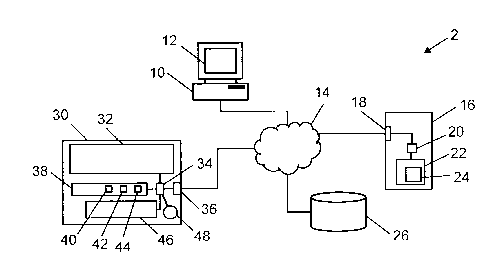
[0006] FIG. 1 is an overview of the geographic asset management system.
[0007] FIG. 2 is a schematic drawing of the system according to an embodiment
of the
disclosed subject matter of the present invention.
[0008] FIG. 3 is a flowchart showing how the system displays data.
[0009] FIG. 4 is a map of the architecture of the system.
[0010] FIG. 5 is a schematic diagram of the framework of the system
[0011] FIG. 6 is a schematic diagram of hidden details displayed on a local
portable
device.
[0012] FIG. 7 is an example of a GIS display showing a 3D view of a building
[0013] FIG. 8 is an alternate representation of the architecture of the system
DESCRIPTION
[0014] Throughout the following description, specific details are set forth in
order to provide
a more thorough understanding of the invention. However, the invention may be
practiced
2
CA 02754225 2011-09-29
without these particulars. In other instances, well known elements have not
been shown or
described in detail to avoid unnecessarily obscuring the invention.
Accordingly, the
specification and drawings are to be regarded in an illustrative, rather than
a restrictive,
sense.
[0015] The detailed descriptions that follow are presented largely in terms of
methods or
processes, symbolic representations of operations, functionalities and
features of the
invention. These method descriptions and representations are the means used by
those
skilled in the art to most effectively convey the substance of their work to
others skilled in
the art. A software implemented method or process is here, and generally,
conceived to be
a self-consistent sequence of steps leading to a desired result. These steps
require
physical manipulations of physical quantities. Often, but not necessarily,
these quantities
take the form of electrical or magnetic signals, values or parameter capable
of being
stored, transferred, combined, compared, and otherwise manipulated. It will be
further
appreciated that the line between hardware and software is not always sharp,
it being
understood by those skilled in the art that software implemented processes may
be
embodied in hardware, firmware, or software, in the form of coded instructions
such as in
microcode and/or in stored programming instructions.
[0016] An overview of the geographic asset management system, generally
designated 2,
is shown in FIG. 1. The geographic asset management system 2 is a combination
of a
traditional GIS component 4 with an asset management system component 6. The
system
2 may be established according to a client-server architecture. For example,
referring to
FIG. 2, a user of the system 2 may access it through a terminal 10, such as a
general
purpose computer, desktop computer, portable computer, laptop computer,
smartphone,
notebook, tablet computer or any suitable computing device that is connectable
to a
network 14 and has a display 12 or is connectable to a device that has a
display. The
network 14 may be the Internet or a local network.
[0017] The user may open up a web browser on terminal 10 and browse to the web
site of
the system 2 which is hosted on server 16 operably connected to the network 14
via
interface 18. The connections in the network 14 may be wired or wireless,
although
normally the connection between the network 14 and the server 16 will be
wired, whereas
3
CA 02754225 2011-09-29
the connection of the terminal 10 may commonly be either. The server 16 houses
one or
more microprocessors 20, operably connected to a memory 22, which may include
non-
volatile and/or volatile memories, electronic memories and/or optical
memories. Stored in
the memory 22 are computer readable instructions 24, which when processed by
the
processor 20 cause the server 16 to implement functions of the components 4
and 6 of the
system 2, as described in detail hereinafter. The server 16 may be a
distributed system for
example a peer to peer network, computer cluster, or other system that can
function in the
capacity of a server as known to one in the art.
[0018] Also connected to the network 14 is a database 26, in which is stored
GIS data,
asset data, geographical coordinates of the assets, notes about the assets,
times related
to the assets, 3D views of the assets, etc. The database 26 alternately may be
located in
the server 16, or it may be locally or remotely connected to it. In other
embodiments, the
database 26 may be divided into a public information part, such as general
geographic
information and coordinates and a private information part, such as details of
a user's
assets. Such private information may be stored on the user's premises or
elsewhere, and
may be password protected and/or encrypted. Collectively the database may
comprise
one or more databases on the server, locally or remotely connected to the
server, or a
combination thereof.
[0019] Also shown in FIG. 2 is an example of another terminal, or mobile
electronic device
which a user may use to interface with the system 2. Basically, the system 2
is
accessible by any web-capable device (Windows, Mac, iOS, Android, etc.).
Device 30
may, for example, be a laptop computer that is connected to the network 14 via
interface
25 36. The device 30 has a display screen 32 in which a web browser can be
displayed for
interacting with the server 16 and data in database 26. Device 30 includes one
or more
processors 34 that connect to and control the components of the device 30,
such as user
input component 46, which may be a keypad, keyboard or even a touch screen
combined
with display 32. A memory 38 is included for storing data and programs that
can be
30 processed by the processor 34. The memory 38 may store, for example, a
browser
application 40, an optional local module 42 of the system and a location
determining
program 44.
4
CA 02754225 2011-09-29
[0020] If a browser is not used, which may be the case in some embodiments,
the local
module 42 may be installed to facilitate the function of specific modules on
the client. Even
if a browser is used, a local component may still be needed for some modules.
Localization of the system will allow it to support multiple languages.
[0021] The location determining program may determine location itself or with
the help of
external devices. For example, it may be a hardware GPS device. It may operate
based on
A-GPS or D-GPS, or it may receive signal strengths from Wi-Fi access points
that can be
used by a remote server to deduce the location of the device 30. The device 30
may also
include an orientation detecting device 48, which may be a compass that may
optionally be
combined with accelerometers, allowing the processor 34 to determine the
pointing
direction of the device 30 and/or changes in the pointing direction. The
accelerometers
may also be used to determine positional changes of the device 30 to a finer
resolution
than can be provided with GPS.
[0022] The computer readable instructions 24 may be prepared using a commonly
known
programming language or toolset, such as VS2010, NET 4.0, Silverlight 4.0,
nUnit, IIS 7.5
Express, SQL, MEF, EF 4.1, etc.
[0023] Referring to FIG. 3, a flowchart is shown of how the system 2 displays
data on a
device 30. As per step 60 the system 2 accepts a user's log in identity and
credential, such
as a password. An organization would set up users at varying security levels,
and then
develop a library of assets based on the specific items they were most
interested in
tracking. A user would only be allowed to access those assets for which he has
been
authorized. In all cases, these assets would have a relation to a specific
geographic
location.
[0024] When the user is logged in, the user is presented with a choice of
queries that can
be made, or the user can define a query. As per step 62 the system 2 receives
whatever
query the user inputs, and, based on the contents of the query, as per step 64
retrieves
GIS information and as per step 66 retrieves further data relating to the
assets that are
being queried. Data may be retrieved from multiple repositories. The assets
can be stored
5
CA 02754225 2011-09-29
in one or more databases, so long as at least one of the databases is
geospatially
enabled. As per step 68 the system 2 then compiles the data into an
appropriate form,
such as a standardized, spatially-enabled form, and then as per step 70
displays the
compiled data on the user's screen.
[0025] FIG. 4 is a map of an example of the architecture of the computer
readable
instructions 24 of the system 2. Other architectures may equally be used. The
architecture
is modularized to provide custom functionality as required by an organization.
In the
present embodiment, the overall architecture 80 has four main parts, these
being the non-
core components 90, the core components 100, the technology 150 and the
modules 160.
[0026] The non-core components 90 include a library 92, a contact manager 94,
an alerting
system 95, a notification system 97 and a 3D visualization application 98. The
3D
application 98 may allow for the management of 3D models, such as permitting
the upload
of a model, upload of a skin, management of names, and management of asset or
asset
type corresponding to the model. A 3D model may be built into or bundled with
a
specification of an asset for unity.
[0027] The notification system module 97 can be configured to notify a user or
group of
users based on events related to an asset. Events and their associated actions
may be
stored as alerts 95. Events may range from specific dates to actions in system
2 (e.g., a
report submitted against an asset). By displaying these events through a
graphical
interface (in this case, the map), an organization can quickly determine the
geographical
relationship between these events to assist in optimizing a response.
[0028] The system core 100 is divided into four main parts. The first part is
security 102,
the purpose of which is to grant access to system functionality and data
subsets by
configuring roles for users through the system's administrator interface.
Security 102 is
based on an additive model. No access is the default and access is added based
on roles.
[0029] Security 102 has an authentication component 104 and an authorization
component
112. The authentication component 104 serves to check a user's identification,
such as a
6
CA 02754225 2011-09-29
unique user name and/or unique email address, and credentials, such as a
password.
Authentication may be achieved externally 106 from the system using LDAP
(Lightweight
Directory Access Protocol), which is commonly used for accessing and
maintaining any
organized set of records over an Internet Protocol network. Other systems,
such as
OpenlD and Active Directory may be used. Alternately, the authentication may
be
achieved internally 108 to the system, or it may be hybrid 110.
[0030] The authorization component 112 of security 102 deals with the
definition of roles
114 and assignment of roles to users. An organizational unit 116 is a logical
group for
partitioning assets. An asset only belongs to one organizational unit
directly. Through the
configuration of relationships between organization units, an asset may be
made available
to other organizational units. A role is a collection of permissions 118 for
access to system
functionality and/or data.
[0031] A position is the intersection of a user, organizational unit 116 and
role 114 defining
the functionality available to a user over an asset. A user can have one or
more roles 114
in one or more organizational units 116 via one or more positions. A user may
change his
personal preferences, such as changing his first and last name, password,
email address,
etc. However, depending on the embodiment chosen, a user name is not editable
by the
user.
[0032] There is no unauthenticated access allowed by the system 2. A guest
account may
be set up as a special account, like the administrator's account, and can be
enabled to
support a "public" style login. The account will be granted permissions
similar to any other
account but users of the account will not be able to modify any of its own
settings or
preferences.
[0033] Security 102 may include both client-side and server-side security,
including
authentication 104, authorization 112 and role-based permissions 118.
[0034] A system administration module may be included in the computer readable
instructions 24 (FIG. 2) to manage various aspects of the system 2. For
example, in
7
CA 02754225 2011-09-29
reference to authorization 112, with respect to users it may be used to add,
edit, delete
users; manage organizational unit associations; and manage role associations.
With
respect to OrgUnits (organizational units 116) it may also be used to add,
edit, delete
OrgUnits; manage user associations; and manage role associations, With respect
to roles
114 it may be used to add, edit, delete roles; manage user associations; and
manage
OrgUnit associations.
[0035] Assets 120, or details of them, form the second part of the core 100 of
the
architecture 80. Assets 120 may be single or generic 122 depending on the
embodiment,
and they are specified with a location 124. The system administration module
may also be
used to manage asset types. Each asset 120 configured in system 2 inherits
security
rights, enabling asset data to be restricted by the user's role in system 2 A
base asset
class may have the following attributes: ID, Name, Description, OrgUnit,
Location,
MapService and FeaturelD. Specific assets may inherit attributes from the base
asset
class.
[0036] Custom assets may be defined, such as buildings or trees. If a building
is defined as
an asset, it may have the following attributes, for example: project,
construction year,
material, use, underground parking, designer name, building revision date,
green status,
heritage, floor height, building width, building length, gross area, and
floors. If a tree is
defined as an asset, it may have the attributes: types, tag, age, height and
morphology.
Other items with or without geographical locations may also be defined as
assets.
[0037] Spatial display (map) 130 is the third part of the core 100 of the
architecture 80. The
map 130 may have layers that are configurable by admin and secured by role.
GIS Tools
may be included, such as pan, zoom, extent, identify and feature query.
Feature query
may display a link to the asset details. Drawing tools may also be included
such as point,
line and polygon, etc. Screen capture may be enabled. Assets 120 may be
displayed on
the map with icons, by type of asset, and the icons may be coloured according
to the
attribute of the asset. It may also be configured to add a new asset at a
point.
8
CA 02754225 2011-09-29
[0038] The fourth part of the core 100 is navigation 140. The navigation 140
may be driven
by a configuration file, which may be managed manually or automatically. The
navigation
function may include navigation elements that point to core screens, screens
within a
module assembly or an arbitrary URL. Navigation 140 may send a user to a URL
in either
a new window or a current window. A navigation element may have the following
attributes: name, which is the text to display on the navigation element; URL,
which is the
destination of navigation action; icon, which is the graphic to display on the
navigation
element if appropriate, DisplayMode, which is whether to display the text, the
icon or both
the icon and text; and roles, being the roles required to be able to see the
navigation
element.
[0039] The modules 160 part of the architecture 80 implement specific and
desired asset
functionality. For example, there may be a community planning module 162, a
building
information management module 164 and a land registry module 166. Further,
optional
modules may be added as desired.
[0040] The building information management system 164 allows space planning in
3D.
Where traditional systems have relied on floor plans, system 2 of the present
invention
depicts in-scale 3D models with selectable rooms. Facility planners using this
BIM module
are now able to see not only rooms, but also the proximity of those rooms to
each other
and other building features (elevators; washrooms; wheelchair ramps, etc.).
[0041] A file manager may be included in the computer readable instructions 24
(FIG. 2) to
manage the various files and records in the system 2. Such a file manager
would allow
files to be saved to disk; maintenance of meta data attributes; and management
of files by
asset user interface plugin (asset), by file manager user interface (asset
type,
organizational unit, unassociated) or by permissions granted to roles.
[0042] The technologies 150 that may be used include presentation applications
152,
databases 154, a GIS 156 and a platform 158. The system 2 may be platform
agnostic, in
that it supports multiple database formats (MS SQL, Oracle, Spatial SQL, etc).
It may also
9
CA 02754225 2011-09-29
support multiple mapping services (Online [Google, Bing, Yahoo], ESRI, AutoCAD
3D
Map, etc).
[0043] FIG. 5 is a schematic diagram showing an example of a framework of the
system 2.
The components of the example architecture 80 described above in reference to
FIG. 4
may be located together within the framework or separately, depending on the
particular
embodiment built. A laptop or other network accessible computing device 200 is
used to
access the application interface 202, which includes interfaces for a business
process
module 204, a data visualization module 206 and a reporting module 208. These
application interfaces may provide the user with access to a document library
220 and a
3D visualization module 222, both of which have access to documents and models
stored
in a model repository 224.
[0044] The user may also access the web application framework 210, which
includes a
module manager 212, a user interface 214, a GIS interface 216 and common
interface
libraries 218. The GIS interface 216 interfaces with GIS / map services 226,
and the
common library interfaces 218 interface with geocoding services 228.
[0045] The web application framework 210 provides the link to the core
framework 240,
which includes a services manager 242, which in turn includes the security
controller 244.
The security controller 244 manages shared data access 246 and local data
access 250.
Shared data that is accessed may be provided by subscription data sources 248.
[0046] Local data access module 250 may link via a database engine 262 to one
or more
databases 264, which may be written in MS SQL Server, Oracle, MySQL or any
other
database programming and access language. Databases may be tabular 270,
archival
272, spatial 274, temporal 276 or media 278. The security controller 244 may
link to the
database(s) 264 via a network domain policies module 260, which may allow
access using
an LDAP, OpenlD, WebADE, Active Directory, etc or a custom protocol.
[0047] As mentioned above, different architectures may be used. An example of
an add-on
module is shown in FIG. 6. Such an add-on module to the core system will allow
users to
CA 02754225 2011-09-29
track assets at a more granular level than traditional GIS systems. For
example, Insight
NR TM (New Reality) as provided by CloverpointTM will provide users with the
ability to
locate and interact with assets that are normally hidden from the naked eye.
Using location
based services, a user will be able to access information about an asset based
on the
location and orientation of their Internet-capable mobile device. The end
effect will be the
virtual ability to look through walls. In FIG. 6, a wall 280 is shown behind
which there are
two pipes 282, 284, which are not normally visible. A smartphone 286 is placed
in
proximity to the wall, and its internal orientation detecting devices and
location based
services allow the server to determine what a user would see if looking though
the wall at
the position of the smartphone and in the direction the smartphone is placed.
In this case,
views 290, 292 of the two pipes are shown on the display screen 288 of the
smartphone.
This module may also be used for visualizing underground pipes, cables and
fibers, etc.
[0048] FIG. 7 shows an example screen shot 300 of a GIS system component 4 of
FIG. 1
enhanced according to the system 2. A user is shown to be logged in as Matt
302,
according to the security setting of the system 2. At the top right of the
screen is a
compass 304 indicating the direction of the view. The geographic (x, y)
coordinates 306 of
the view (or the centre point of the view) are also displayed. Alternately,
the coordinates
given may be that of a cursor that can be tracked over the view. The z
coordinate may also
be displayed. The view shows contours of a hillside 307 and a group of
buildings 308. A
3D model of a building 310 is also shown. This building may be defined as an
asset of the
system. The building may be selected, or floors or rooms of the building may
be selected,
and then navigated to.
[0049] A menu bar 320 allows a user to easily move around the site. For
example, the user
may switch from a 3D view to a 2D view. The user may toggle the buildings
layer on and
off. The user may go to the main page, the settings page or the admin page.
The user may
go to a library listing all the assets.
[0050] Navigation display block 330 allows the user to toggle the walk mode
332 on and
off, and to toggle the night mode 334 on and off. The speed at which the view
is explored
may be set by a slider 336. Alternately, dates may be entered explicitly,
selected or
stepped through, etc. Below the navigation block there may be a history
slider, which can
11
CA 02754225 2011-09-29
change the view according to date, which may also be displayed alongside the
slider. As
an organization collects data on assets over time, it can make use of the
timescale
functionality to track historical trends in order to better configure the
notification system
(i.e., an equipment failure at plant A will raise the load at plant B to
critical levels within 2
days, unless plant C is brought online). Where most traditional GIS systems
are reactive in
nature, the present system provides users with a decision support system to
optimize their
future plans.
[0051] The tombstone block 340 displays headings for the asset selected, the
values of
which are shown in data block 342. Shown, for example, in block 342, is the
name of the
building that is selected, the construction date, and a specific floor if one
is selected (either
by clicking on the 3D building model or by selecting from the up/down
selection arrows.
The location of the building may be displayed by showing its geographic
coordinates. Any
notes that have been added to the system 2 may also be displayed. Depending on
the
permission granted to the user, the user may be able to add or edit notes
relating to the
building. In a similar way, a selected portion of the asset may be shown in
heading block
350 and data block 352. For example, if a room of the building is selected,
the room name
or number may be shown, the faculty to which it belongs, the department, the
unit, the
space type (e.g. lab, office, meeting room, canteen, etc.) and the next
scheduled
maintenance date. Users may add and remove assets as a way to facilitate the
consideration of alternate scenarios.
[0052] FIG. 8 is a representation of an alternate example of the system 2.
Devices 10, 30
allow users in the cloud to connect to the system 2 via the Internet 14. Such
a device may
also be used for viewing hidden detail, as described with respect to FIG. 6.
Connection is
via a security module 244 and a data filter module 400. The data filter allows
users to read
and write to the databases depending on their authorization levels, or roles.
(0053] Reading functions may use one or more load balancers 402, one or more
image
caches 404 and one or more data caches 406 to retrieve data 412 from various
web sites
408, databases 418 and the GIS 416. Writing functions may use one or more load
balancers 402 and one or more data caches 406, and data to be written may be
queued
12
CA 02754225 2011-09-29
414 before being written to a database 418. Asset information 412 may be
backed up
either by mirroring the database(s) or by striping them.
[0054] Modules, components, features etc. of the architecture and/or framework
may be
grouped differently to the embodiments shown herein. Some may be omitted, and
others
added. As will be apparent to those skilled in the art in the light of the
foregoing disclosure,
many alterations and modifications are possible in the practice of this
invention without
departing from the spirit or scope thereof. Accordingly, the scope of the
invention is to be
construed in accordance with the substance defined by the following claims.
15
13