Note: Descriptions are shown in the official language in which they were submitted.
CA 02767757 2012-01-09
WO 2011/031874 PCT/US2010/048289
DIP GUIDED FULL WAVEFORM INVERSION
FIELD OF THE DISCLOSURE
[0001] The present disclosure generally relates to dip-guided full waveform
inversion (DG-
FWI) that combines dip-guide methodology (Hale, 2009) with the full waveform
inversion
(FWI) process (e.g. Bunks, et al., 1995; Pratt, 1999) to obtain a dimension
reduction technique
(e.g. Yang & Meng, 1996) that can greatly reduce difficulties encountered in
FWI.
BACKGROUND OF THE DISCLOSURE
[0002] Full waveform inversion (FWI), is a well studied and extensively
published subject
(e.g. Bunks, et al., 1995; Pratt, 1999). Recent technical developments have
shown that seismic
velocities produced by FWI can produce high resolution detail. This detail can
provide valuable
attributes for the purposes of depth imaging, pore pressure prediction and
stratigraphic
description. FWI utilizes an inversion method adjusting the trial velocity
model to match the
synthetic wavefield and the recorded wavefield through a forward modeling
process. However,
despite the significant potential, it has been challenging to apply this
technique, which may be
formulated in either time (Lailly, 1983; Tarantola, 2005) or frequency domains
(Pratt, 1999 a &
b), on full-scale 3D models.
[0003] Carrazzone and associates, US5583825, use pre-stack seismic reflection
data at a
subsurface calibration location to derive lithology and fluid content at a
subsurface target
location. Cross and Lessenger, US6246963, use a mathematical inverse algorithm
to modify
values of process parameters to reduce the differences between initial model
predictions and
observed data until an acceptable match is obtained. In US6980254, Nishihashi
and associates
use an image interpolation system where virtual interpolation data generate
data for inter-lines
between the lines of the input image that extracts matching patterns. Perez,
et al., US6856705,
provide a blended result image using guided interpolation to alter image data
within a destination
domain. Saltzer and associates, US7424367, predict lithologic properties and
porosity of a
subsurface formation from seismic data by inverting the seismic data to get
bulk elastic
1
CA 02767757 2012-01-09
WO 2011/031874 PCT/US2010/048289
properties across the subsurface formation; a rock physics model of the
subterranean formation is
constructed and builds a fluid fill model indicating the type of fluid present
at each location in
the subsurface. In US7480206, Hill uses energy components like velocity and
shape to create an
energy lens model where seismic targets are updated by transforming an energy
component
through the energy lens model.
[0004] Sherrill and Mallick, US7373252, improve upon existing pre-stack
waveform
inversion (PSWI) by generating a macro P-wave velocity model using reflection
tomography,
comparing the macro P-wave velocity model to the seismic data set, and
updating the macro P-
wave velocity model iteratively. In US7254091, Gunning and associates simulate
spatial
dispersion within a layer of the seismic inversion by vertically subdividing
the layer and
modeling the layer consistently with a vertical average including Bayesian
updating to estimate
and reduce uncertainty in a reservoir model. Tnacheri and Bearnth, US7519476,
use
geopopulation and genotype analysis to model reservoir features by analyzing a
series of
properties (genotype) simultaneously.
[0005] Full wave form inversions (FWI) are difficult to perform, simulating
large quantities
of data, and require a large amount of processing to achieve a final model
that incorporates
lithology in the seismic data. Foster and Evans (2008) provide a recent
evaluation of FWI for
geophysical applications. The methods described above reduce the amount of
data analyzed,
analyze data in larger blocks, layers, or levels that do not mimic the
lithology of the system.
These methods also generalize and require multiple iterations to identify the
"correct" model that
fits the data. Because many of these methods sample the data in a uniform and
unweighted
manner, changes in the data and the underlying lithology may be overlooked by
these models.
[0006] A method of seismic data modeling is required that accurately
identifies the
underlying lithology of the formation while minimizing the misfit between the
modeled data and
the recorded data. This is complicated by noise in the seismic data and
artifacts within the data
that obscure the true lithology. To increase resolution and obtain data within
areas with artifacts
a method is required that addresses problems concealed within the inversion
procedure including
convergence speed, number of iterations required for convergence, determining
correct inversion
2
CA 02767757 2012-01-09
WO 2011/031874 PCT/US2010/048289
model as there are multiple different models that may represent the data, and
removing
amplitude and non-linearity problems associated with the current techniques.
BRIEF DESCRIPTION OF THE DISCLOSURE
[0007] In order to overcome the difficulties of FWI, a method using dip-guide
methodology
with the full waveform inversion process, or "dip-guided full waveform
inversion" (DG-FWI) is
utilized to generate velocity models. The process is two-fold, using Hale's
(Hale, 2009) image-
guided interpolation methodology and a revised FWI methodology with a DG-FWI
approach
which incorporates dimension reduction techniques (e.g. Yang & Meng, 1996)
that can greatly
reduce the difficulties encountered in FWI, both incorporated by reference.
The DG-FWI reduces
the size of the inversion and the computational cost while it mitigates some
of FWI's
shortcoming with respect to the dependence on the very low-frequency seismic
data; and
generally improves model convergence.
[0008] The term "dip-guide" is also referred to as "image-guided
interpolation" or "blended
neighbor interpolation" introduced by Hale (Hale, 2009). Hale's image-guided
interpolation is
designed specifically to enhance the process of interpolation of properties at
locations some
distance from boreholes by use of the dip information gained from the image.
[0009] Velocity models were developed by: a) obtaining seismic data, b)
calculating the
misfit gradient by back-projecting the residual with respect to the model, c)
preparing a dip-
guide from the seismic data, d) preparing measurement points, e) calculating
the misfit gradient
with respect to the measurement points, and f) developing a full waveform
inversion model using
the dip-guide, wherein the dip-guide (tensor field) is used to condition full
waveform inversion.
Steps (b) through (f) may be repeated one or more iterations to improve
forward model
resolution. Additionally, steps (d), (e), and (f) may be repeated to further
sharpen forward model
resolution.
[0010] Alternatively, velocity models were developed by: a) obtaining seismic
data, b)
calculating the misfit gradient by back-projecting the residual with respect
to the model, c)
preparing a dip-guide from the seismic data, d) preparing measurement points,
e) calculating the
3
CA 02767757 2012-01-09
WO 2011/031874 PCT/US2010/048289
misfit gradient with respect to the measurement points, f) developing a full
waveform inversion
model using the dip-guide, and g) repeating steps (b), (c), (d), and (e)
wherein the dip-guided
inversion model provides an initial model for full waveform inversion.
Additionally, steps (d),
(e), and (f) may be repeated to further sharpen forward model resolution.
[0011] The above velocity models may be developed by a) obtaining seismic data
on a
computer readable media, b) transferring the seismic data to a velocity
analysis system, c)
calculating dip-guide from the seismic data, d) performing a full waveform
inversion model
using the dip-guide (tensor field) in the velocity analysis system, wherein
the dip-guide is used to
condition full waveform inversion.
[0012] Seismic data may be obtained from any number of sources including
recent seismic
surveys, databases of past seismic surveys and commercial databases with a
variety of data types
including but not limited to seismic data, velocity models, tomography
surveys, and the like.
[0013] The misfit gradient may be calculated by back-projection of the
residual error
between the original data and the current velocity model. A misfit gradient
may also be obtained
that uses additional information including seismic models from a variety of
disciplines, fracture
analysis studies, and the like.
[0014] The dip-guide may be calculated as the tensor field that represents the
underlying
seismic data. Measurement points are identified from the dip-guide at changes
in the tensor
field. The dip-guided inversion model may be represented by mk = Ixk or Omk =
IOxk , where
k is the iteration index. The forward model is analyzed for changes in the
misfit gradient and the
full waveform inversion is repeated 1 or more times to improve forward model
resolution. The
forward model will help resolve anomalies in the seismic data including low
velocity zones, high
velocity zones, gas zones, salt zones, or other features. Changes in misfit
gradient may be
monitored for migration from iteration to iteration. Velocity modeling can be
used on seismic
data from refraction tomography, surface reflection tomography, transmission
tomography,
previously developed models and/or more other seismic studies. Full waveform
modeling
iterations are reduced by dip-guided inversion modeling when compared to full
waveform
4
CA 02767757 2012-01-09
WO 2011/031874 PCT/US2010/048289
modeling alone. Dip-guided inversion modeling may reduce the processing and/or
time
requirements by 2-20 fold. Dip-guided inversion modeling has been shown to
reduce processing
and/or time by 5-10 fold, and can reduce the processing and/or time by greater
than 8 fold. A
variety of commercial and privately developed velocity analysis systems can be
used for dip-
guided inversion modeling including 3D Model Builder, Seismitarium, ModSpec,
Vest3D,
Velocity Model Building (VMB), and reflection tomography.
BRIEF DESCRIPTION OF THE DRAWINGS
[0015] FIG. 1: Synthetic models. FIG. 1 through FIG. 6 show the mechanism of
DG-FWI
through a synthetic data. FIG. IA shows the true velocity while FIG. 1B shows
the initial
velocity. The true velocity model includes a V(z) model referenced on the
water bottom, a
deeper flat reflector and anomalies. The anomalies consist of a low velocity
gas zone (LVZ) and
the high velocity bar (HVB). While the initial velocity model does not include
the anomalies. In
the data, there are 148 shots with shot spacing of 60ft and receiver spacing
of 30ft. Depth
spacing is 30ft, and dominant frequency is 10Hz. The chosen frequency 10Hz is
intentionally
slightly higher than desirable for FWI, however it is designed to test the
robustness of the DG-
FWI methodology. FIG. 1 C shows the difference between the true velocity model
and the initial
velocity model.
[0016] FIG. 2: Forward modeling results and misfit gradient. Demonstrates
forward
modeling and misfit gradient with an FWI analysis. FIG. 2A shows a sample shot
with the true
velocity model FIG. IA. FIG. 2B shows a sample shot with the initial velocity
model FIG. 1B,
which only generates the reflection from the deeper flat reflector. FIG. 2C
shows the misfit
gradient obtained by solving the adjoint system of the forward modeling. In
this synthetic test,
FIG. 2C will be used to calculate the dip guide.
[0017] FIG. 3: FWI results with 1, 5 and 20 iterations. FIG.3A shows the
velocity
perturbation (AV) after one iteration, FIG. 3B shows the AV after 5
iterations, and FIG. 3C
shows the AV after 20 iterations of inversion. Clearly the FWI is struggling
to converge to the
true solution of FIG. 1 C, maybe due to the lack of low frequencies in the
synthetic dataset (with
CA 02767757 2012-01-09
WO 2011/031874 PCT/US2010/048289
high dominant frequency of 10Hz). FIG. 3D shows the forward modeling results
after 5
iterations of FWI, indicating there are a lot of discrepancies generated,
compared to the true
wavefield FIG. 2A.
[0018] FIG. 4: Dip guide, DG-FWI inversion results. FIG. 4A, first of all,
shows the dip
guide (namely the tensor field) displayed as ellipses calculated from the
misfit gradient FIG. 2C;
secondly, 6 measurement points are used and marked as the red crosses. Next,
FIG. 4B is
generated by one iteration of DG-FWI, which is already close to the true
velocity perturbation
AV as shown in FIG. 1 C. Then, FIG. 4C shows the result with one iteration of
DG-FWI followed
an extra one iteration of FWI, which gives better result than a DG-FWI alone
(FIG. 4B). The
extra FWI following the DG-FWI in fact brings in some sharp boundaries. This
latter strategy
has been recommended in the workflow. It is worth mentioning that to obtain
the best result of
FIG. 4C, only 2 iterations (one DG-FWI and one FWI) of forward modeling and
inversion are
required, which converges much faster than the FWI (FIG. 3A, 3B, 3C).
[0019] FIG. 5: Forward modeling results. Data fitting between the FWI and DG-
FWI
methodologies, FIG. 5A (the same as FIG. 2A), shows the true data while FIG.
5B shows the
modeling data from the best DG-FWI model obtained in FIG. 4C. To compare with
a FWI
model, FIG. 5C shows the data residual between the true data FIG. 5A and the
modeling data
from a FWI model FIG. 3C; in comparison with FIG. 5D showing the data misfit
residual
between the true data FIG. 5A and the modeling data FIG. 5B. Clearly the DG-
FWI residual
FIG. 5D diminishes while the FWI residual FIG. 5C hardly converges to zero.
[0020] FIG. 6: Reverse time migration comparisons. FIG. 6A-6C show the RTM
(reverse
time migration) image comparison derived from the DG-FWI and FWI velocity
models. FIG. 6A
shows the RTM image migrated from the initial velocity model FIG. 1B; FIG. 6B
shows the
RTM image migrated from the FWI model FIG. 3B and FIG. 6C shows the RTM image
migrated from the DG-FWI model FIG. 4C. Clearly the DG-FWI model FIG. 4C
produces the
best image. In particular, the deepest reflector in FIG. 6C is perfectly flat,
while that in FIG. 6A
and 6B are not flat.
6
CA 02767757 2012-01-09
WO 2011/031874 PCT/US2010/048289
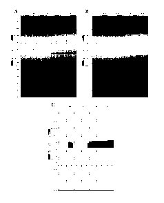
[0021] FIG. 7 Field data comparisons. FIG. 7 and 8 show the DG-FWI through a
difficult
imaging area. FIG. 7A shows the starting velocity model; FIG. 7B shows the RTM
image
migrated from the starting velocity model FIG. 7A, overlain by the dip guide
calculated from the
image; FIG. 7C shows the updated model after one DG-FWI followed by one FWI;
FIG. 7D
shows the RTM image after 8 FWIs; and FIG. 7E shows the RTM image after one DG-
FWI and
one FWI. There are visible improvements in the images in FIG. 7E over FIG. 7D.
The improved
image of FIG. 7E by DG-FWI only takes 1/4 run time of FIG. 7D by pure FWI.
[0022] FIG. 8 Kirchhoff Gathers comparisons. FIG. 8A shows the Kirchhoff
gathers close to
an obscured zone migrated using the pure FWI model (FIG. 7D) and FIG. 8B shows
the
Kirchhoff gathers migrated using the DG-FWI model (FIG. 7E). Overall gathers
are flatter in
FIG. 8B in most areas. The DG-FWI produces superior results with 1/4 of the
computing costs of
the pure FWI.
DETAILED DESCRIPTION OF EMBODIMENTS OF THE INVENTION
[0023] In essence, the present invention DG-FWI provides a dip guide (DG) to
constrain the
full waveform inversion (FWI). The dip guide is calculated using Hale's
methodology (Hale,
2009) which can greatly reduce the size of the FWI. This reduces the dimension
of the inversion
and improves the convergence greatly (e.g. Yang & Meng, 1992).
[0024] Vienot and associates, US5835882 incorporated by reference, use both
seismic and
petrophysical data to determining flow characteristics within a reservoir
layer, by assigning a
numerical connectivity factor (CF) to subvolumes within the volume, averaging
planar
connectivity factors for simulation cells of 4 or more subvolumes; where the
numerical flow
values for the simulation cells demonstrate flow barriers within said
reservoir layer. In
US5835883, they use a forward model based on a 3-D seismic survey and well log
data that
recognizes the nonunique inversion (NUI) of seismic/lithologic parameters to
generate column
subvolumes in the reservoir and horizontal slices of the model volumes.
Parameters are
averaged across the horizontal slices and plotted to obtain a depth versus
parameter trend for the
reservoir. Each model cell may then be analyzed within the reservoir model.
7
CA 02767757 2012-01-09
WO 2011/031874 PCT/US2010/048289
[0025] Onyia and associates, US6473696 incorporated by reference, coordinate
known
parameters with seismic velocities by identifying interpreted seismic horizons
in seismic data
and obtaining estimated seismic velocities corresponding to the interval
between seismic
horizons at any location within the seismic survey. Neff, US6654692
incorporated by reference,
uses "cellular" inversion of like data cells to predict rock properties of a
subsurface formation.
Seismic survey data and well log data are analyzed by generating synthetic
seismic data based on
well log data with discrete synthetic data subcells based on seismic
attributes; seismic surveys
are used to generate discrete reflection data subcells based on the same
seismic attributes as the
log data; and reflection data subcells are coordinated with a corresponding
synthetic data
subcells based on the seismic attributes of the reflection and synthetic
seismic data. Anno and
Routh, US2008189043 incorporated by reference, use prestack inversion of a
reference dataset to
normalize a second later prestack inversion where the misfit from one dataset
to the next
identifies changes in the model-difference time lapse inversion.
[0026] Velocity modeling uses FWI to determine travel time & amplitude from
seismic data
including reflection, refraction & transmission data. Tarantola (2005),
incorporated by
reference, and Pratt (1999 a & b) describe in detail the use and manipulation
of a full waveform
inversion:
do F(m)
min E=2 -F(M)112
E(m+Am)=E(m)+OfTVmE+ I AMTHSm+...
where do is the measured data, F(m) is the data model; min E is the minimum
error of the model;
E(m) being the error across the function; VmE is the misfit gradient; H is the
Hessian
associated with the misfit function; and Am is the change in model. The
waveform inversion
minimizes the error E(m) iteratively, eventually converging on a model where
error is
minimized for the current estimation. The minimum error may not be the true
convergence of
the function as an artificial minimum may be reached or the model may not
accurately describe
the full dataset in the forward model. The problem has no unique solution, as
there exists an
infinite number of functions that satisfactorily describe the seismic data.
8
CA 02767757 2012-01-09
WO 2011/031874 PCT/US2010/048289
[0027] Therefore to interpolate from known positions to the entire model, an
estimate for
inversion must be smooth, bounded, and fast to compute. Instead of
interpolating over a fixed
distance forcing the interpolated solution to have even dispersion over the
entire distance, the
interpolation is averaged based on lithology by using the dip guide (Hale,
2009). This allows a
variety of distances between points as seen in the lithographic models and
attributed to features
in the actual dataset. By using a DG-FWI analysis the forward model and the
data converge
rapidly with less processing:
do z F(m) z F((Dx)
minE=~ do - F(Ix)z
x
xk+1 - Xk + akVxE
mk+1 = (Dxk+l
where m is the forward model data at k+1, 1 (phi) is the dip guide, and xis
the actual data at
k+l. The model for x at k+1 is x at k with the misfit at k. Thus the model mat
k+1 is the
product of the dip guide 0 and the data x at k+1.
[0028] Using the DG-FWI, the calculation burden is estimated to be reduced at
least by 8
fold for typical 3D project, amplitude is enhanced across the model, hence the
formation
properties can be estimated more reliably due to the increased accuracy of the
velocity model.
Because of the smaller computational burden with DG-FWI, more analyses may be
conducted
over a larger area to develop a better model with higher resolution than
previously obtained.
Additionally, the data quality is improved including enhanced amplitudes;
thanks to the dip
guide, low frequency information can be incorporated into the velocity model.
In nature, the dip
guide tends to honor the geological compartment, as a result, the DG-FWI
produces better
velocity model that are often meaningful in terms of geology and stratigraphy
(Hale, 2009).
[0029] The present invention will be better understood with reference to the
following non-
limiting examples.
9
CA 02767757 2012-01-09
WO 2011/031874 PCT/US2010/048289
EXAMPLE 1: SYNTHETIC DATA ANALYSIS
[0030] To test the DG-FWI, model data were generated. A true model was
generated by
referencing V(z) to a water bottom, adding a deep flat reflector, low velocity
gas zone (LVZ) and a
high velocity bar (HVB) anomalies. By definition, the starting model was the
true model without
two anomalies. The true dataset was "generated" with 148 shots with a spacing
of 60 ft. Receiver
spacing was at 30 ft with a depth interval of 30 ft. The dominant frequency in
this model was 10
Hz, quite high for FWI but is intentionally designed to test the robustness of
the DG-FWI. This
true model was used to generate synthetic data that represent the features and
anomalies as
described.
[0031] FIG. 1 . shows the true model, the starting model and their difference.
The true velocity
model FIG. IA shows features including the water bottom, a low velocity zone
(LVZ), a high
velocity bar (HVB), and a deeper flat reflector. This simple model was
analyzed with an initial
velocity model FIG. I B that does not show the LVZ or HVB. The velocity
difference in FIG. 1 C
clearly shows the absence of the LVZ and HVB from the initial velocity model.
As expected,
forward modeling with the initial velocity model generates a synthetic data
F(m) in FIG. 2B that
does not contain the same events as that generated by the true velocity model
FIG. 2A. From the
difference between FIG. 2A and FIG. 2B, we can calculate the misfit gradient
FIG. 2C. The
difference between FIG. 2A and FIG. 2B shows the initial velocity model does
not produce an
accurate representation of the synthetic data. A more detailed analysis was
required to account for
changes in velocity.
[0032] Initially, FWI was used to analyze the data by forward modeling, F(m).
When driving
F(m) to approach to the synthetic data, do, velocity changes are obtained.
These velocity changes
are easily visualized as shown in FIG. 3A, 3B, & 3C, with one, five and twenty
iterations
respectively. In this case the error in the velocity change between the
velocity model and the
predicted velocity model actually increased after 5 iterations. Indicating
using more than 5
iterations of FWI's does not generate a better model. Differences between the
modeled data and
the true data can also be seen by the artifacts (additional signals) visible
in FIG. 3D. Simple FWI
analysis with 1, 5 or 20 iterations was insufficient to accurately describe
the synthetic model even
with known features.
CA 02767757 2012-01-09
WO 2011/031874 PCT/US2010/048289
[0033] To use a dip-guided FWI, the dip guide (namely, tensor field) is used
to guide the FWI.
In FIG. 4A, the dip guide is first calculated and seen with features that
correlate to the misfit
gradient FIG. 1C. With just one iteration of DG-FWI, FIG. 4B, thus accurately
recovers
differences from the underlying data. An additional simple FWI continues to
refine the model,
accurately depicting the underlying data as shown in FIG. 4C. The LVZ and HVB
boundaries are
well defined and accurately reflect the true data that underlie the velocity
model. Thus one DG-
FWI followed by one FWI, can more accurately match the synthetic data and true
data, than the
simple FWI after many iterations (see FIG. 3).
[0034] Further, forward modeling of the DG-FWI model, as shown as FIG. 5B, is
comparable
to the true data, FIG. 5A. There are minimal differences between the DG-FWI
modeling data and
the true data shown in FIG. 5D. For comparison, by itself the FWI misfit data
(FIG. 5C) shows
many differences around the features. In this example, FWI may not converge
because the 10 Hz
Ricker wavelet does not contain as much information as lower frequencies near -
3 Hz. This
clearly demonstrates that the DG-FWI is more robust and works even in the
absence of low
frequencies.
[0035] Another way to analyze the velocity model is to monitor the image. The
best quality
image is generated by Reverse Time Migration (RTM). In FIG. 6 the RTM images
are shown for
the initial velocity model FIG. 6A, the FWI model FIG. 6B and the DG-FWI model
FIG. 6C. For
the initial velocity model, FIG. 6A, the deep reflector is not depicted as
flat, and the boundaries of
the LVZ and HVB are incorrect, shifted from their true location. The FWI
velocity model FIG. 6B
likewise does not accurately depict the deep reflector because it is curved
and the feature
boundaries for LVZ and HVB are not improved. Only the DG-FWI depicts the flat
deep reflector
and properly places the boundaries for the LVZ and HVB. Thus in order to
accurately depict even
a simple model FIG. IA, only DG-FWI will accurately identify the true feature
(deep reflector) and
anomalies (LVZ and HVB) allowing better imaging of the underlying structures.
[0036] As shown in FIG.2-6, DG-FWI can be used to accurately develop a
velocity model for
seismic data that accurately depicts structures and anomalies. The improved
method quickly
updates velocity model without an extensive number of iterations. The DG-FWI
inversion
converges with fewer iterations, and a couple additional FWI iterations may be
added to sharpen
11
CA 02767757 2012-01-09
WO 2011/031874 PCT/US2010/048289
the boundary of the formation. The DG-FWI works with 10 Hz data, converging to
the correct
model even when FWI does not converges to the correct velocity due to the lack
of low
frequencies. This demonstrates that DG-FWI is superior to FWI in dealing with
data missing low
frequencies (-3 Hz). This is great news since a lack of low frequencies has
been a big issue for
FWI (Pratt, 1999a; 1999b), both incorporated by reference.
EXAMPLE 2: ANAYLISIS WITHIN A LOW VELOCITY GAS ZONE
[0037] Although DG-FWI accurately assessed the structures and anomalies within
a synthetic
dataset a more complex system was analyzed to determine applicability to field
data. As shown in
FIG. 7A, an initial model was used for this test. For this data, each FWI
required approximately 2
hours on a 100-node cluster. This data, made up of 1200 shots with a 25 m
spacing, was acquired
to image a gas cloud anomaly. The receivers were spaced at 12.5 m and a depth
of 10 m.
Anomalies and features for this dataset were not pre-defined and the model was
developed based
solely on the DG-FWI analyses. An RTM image with the starting model is
overlain with the dip
guide tensors that will guide the DG-FWI analyses. Although the samples are
regularly selected
(20 x 10), the dip guide provides accurate and relevant guidance for the
subsequent FWI inversion,
and the underlying data dictate the size, shape and direction of the tensor.
[0038] The updated DG-FWI velocity model shown in FIG.7C more accurately
reflects the
feature boundaries than the original model in FIG.7A. An RTM image migrated
from FWI model
shown in FIG. 7D improves contrast and coherence in the image after 8 FWI
iterations, but the
RTM image from the DG-FWI model (1 DG-FWI plus 1 FWI) shown in FIG. 7E further
enhances
the image and reveals features invisible with the FWI model. The DG-FWI
sharpens the fault
structures, which are visible and the true lithography becomes more enhanced,
DG-FWI also
enhance features and allow visualization where a gas anomaly, located in the
top-center, becomes
visible.
[0039] Overall, the DG-FWI analysis, namely, one DG-FWI followed by one FWI,
clearly
identifies structural features and gas anomalies allowing the use of less
perfect data. The DG-FWI
analysis also requires fewer iterations, increasing clarity while decreasing
computational
12
CA 02767757 2012-01-09
WO 2011/031874 PCT/US2010/048289
requirements. Image resolution can be further clarified by increasing the
number of combined DG-
FWI and FWI iterations.
[0040] Another way to quality control (QC) the result is to examine the
migrated gathers. In
most gas zones, data are noisy because the low velocity gas zone absorbs most
of the relevant
frequencies. The gas anomalies throughout the area obscure the true lithology
of the underlying
formation. A common image gather (CIG) generates a partial image of the
underlying formation.
Unfortunately the narrower bandwidth of data reduces the ability to clarify
the image and develop
a velocity model. As shown in FIG. 8A, the initial velocity model has shown
the velocity is too
fast in the gas cloud and some of the gathers away from the gas cloud are
still not flat. Using DG-
FWI, the image gathers generated from the DG-FWI updated model are enhanced,
as shown in
FIG. 8B, where the size of the gas cloud is reduced and some gathers away from
the gas cloud
zone become more flat. Not only are the CIG gathers are flattened by DG-FWI,
FIG. 8B, but also
the resolution is increased, Moreover, the DG-FWI used only 1/4 of the run-
time by FWI.
[0041] DG-FWI improves velocity analysis of seismic data by providing more
rapid
convergence, increasing resolution and improving model accuracy. DG-FWI
analysis is also more
robust in dealing with data that lacks low frequencies. Although the systems
and processes
described herein have been described in detail, it should be understood that
various changes,
substitutions, and alterations can be made without departing from the spirit
and scope of the
invention as defined by the following claims.
REFERENCES
[0042] All of the references cited herein are expressly incorporated by
reference.
Incorporated references are listed again here for convenience:
1. US5583825 (Carrazzone, et al.) "Method for deriving reservoir lithology and
fluid content from pre-stack
inversion of seismic data," Exxon Production Res. (1996). See also W09607935.
2. US5835882 (Vienot, et al.) "Method for determining barriers to reservoir
flow," Phillips Petroleum Co (1998).
See also W09836292.
3. US5835883 (Neff) "Method for determining distribution of reservoir
permeability, porosity and pseudo relative
permeability," Phillips Petroleum Co (1998). See also W09834190.
4. US6246963 (Cross and Lessenger) "Method for predicting stratigraphy,"
Platte River Assoc (2001). See also
US6754588 and US2002099504.
13
CA 02767757 2012-01-09
WO 2011/031874 PCT/US2010/048289
5. US6473696 (Onyia, et al.) "Method and Process for Prediction of Subsurface
Fluid and Rock Pressures in the
Earth," ConocoPhillips (2002). See also US6751558, US6977866 US2002169559,
US2003004648,
US2004141414, W002073240, and W02004018822.
6. US6654692 (Neff) "Method of predicting rock properties from seismic data,"
ConocoPhillips (2003). See also
W02004049004.
7. US6856705 (Perez, et al.) "Image Blending By Guided Interpolation,"
Microsoft Corp (2004). See also
US2004165788, W02004077347, US7038697, US7427994, US2004164992, and
US2005237341.
8. US6980254 (Nishihashi, et al.) "Image interpolation system and image
interpolation method," Sharp KK (2005).
See also WOO 117243.
9. US7254091 (Gunning, et al.) "Method for estimating and/or reducing
uncertainty in reservoir models of
potential petroleum reservoirs," BHP Billiton Innovation Pty (2007).
10. US7373252 (Sherrill) "3D Pre-Stack Full Waveform Inversion," Western Geco
L.L.C. (2007). See also
US2007203673.
11. US7424367 (Saltzer, et al.) "Method For Predicting Lithology And Porosity
From Seismic Reflection Data,"
ExxonMobil Upstream Res. Co. (2008). See also US2008015782 and W02005119276.
12. US7480206 (Hill) "Methods for earth modeling and seismic imaging using
interactive and selective updating,"
Chevron U.S.A. (2006). See also US2006056272 and W02006031481.
13. US7519476 (Tnacheri and Bearnth) "Method of seismic interpretation,"
Seisnetics LLC (2009).
14. US2008189043 (Anno) "Direct Time Lapse Inversion of Seismic Data,"
ConocoPhillips Co. (2008). See also
W02008097748.
15. Bunks, et al., (1995).
16. Hale, "Image-guided blended neighbor interpolation," Center for Wave
Phenomena, Colorado School of Mines,
Golden CO (2009).
17. Lailly, (1983).
18. Pratt, "Seismic waveform inversion in frequency domain, Part 1: Theory and
verification in physical scale
model," Geophysics, 64, 888-901(1999-a).
19. Pratt, "Seismic waveform inversion in frequency domain, Part 2: Fault
delineation in sediments using cross hole
data," Geophysics, 64, 902-914 (1999-b).
20. Tarantola, A., "Inverse Problem Theory: Methods for Data Fitting and
Parameter Estimation" Elsevier,
Amsterdam, (1987).
21. Yang & Meng, (1996).
14