Note: Descriptions are shown in the official language in which they were submitted.
CA 02772259 2014-02-24
ICE DATA COLLECTION SYSTEM
FEDERALLY SPONSORED RESEARCH OR DEVELOPMENT
[00021 None.
FIELD OF THE INVENTION
[00031 This invention relates to systems for detecting and characterizing
ocean ice floes.
BACKGROUND OF THE INVENTION
10004] Because the demand for oil and gas continues to grow, safer and more
reliable
methods of developing oil and gas fields need to be developed. Producing gas
from the Arctic
Ocean provides unique challenges, especially as drilling moves into deeper
water depths, faces
more severe ice conditions, and as well complexity increases.
[00051 Ice floe detection has been developed using a variety of ice
monitoring systems.
Strass (1998) derive ice draft and coverage from acoustic measurements made
with moored
Upward Looking Sonars (ULSs) sounding the sea surface remotely from below.
Harms, et al.,
(2001) use moored ULS data to measure sea ice draft. Wadhams, et al. (2006)
developed an
autonomous underwater vehicle (AUV) for under-ice studies with unmanned under-
ice vehicle
and a multibeam sonar. Hyatt, et al., (2008) use upward-looking acoustic
Doppler current
profiler (ADCP) to determine ice coverage with moored systems. (Theriault, et
al., 2009).
[0006] Johnson, GB2223642, describes methods of tracking the movement of
sea-ice using
successive images from orbiting satellites. Deines and Maier, US5122990,
indicate that a signal
echo may be used in an upward looking configuration to measure the movement of
sheets of ice
in one of the polar regions. Glynn, et al., US5381694, provide a relatively
inexpensive
reflectometer apparatus that can measure the thickness of material such as
ice. Yankielun and
Ferrick, US5585799, pertains to a microwave continuous wave (CW) Doppler radar
system for
river ice motion detection and real-time kinematic data acquisition using
digital signal processing
equipment. Matsuoka, et al., US7095359, describe an ice thickness/drifting
velocity observation
CA 02772259 2012-02-24
WO 2011/149658 PCT/US2011/035942
of sea ice by using an ice thickness measurement sonar and a current meter
moored into the sea
and a sea ice observation by a high-resolution airborne SAR are synchronously
performed to
calculate a correlation between a draft profile of sea ice passing over the
sonar and an SAR
backscattering coefficient profile. Williams and Yankielun, US6700528, provide
a compact and
relatively inexpensive motion detection and alerting system implemented in a
single,
environmentally secure and benign package. Although a variety of ice floe
monitoring
equipment has been developed, these systems are limited to small areas, fixed
positions within
the ocean or near the equipment, or limited in the amount of time available.
[0007] Oil and gas companies wishing to drill and develop an oil or gas
field in the offshore
Arctic Ocean need to know on a near continuous basis what kind of ice
environment they are
dealing with. In the Alaska and Beaufort Canadian areas of the Arctic Ocean,
the ice is usually
composed of "floes", large bodies of ice that may extend up to several hundred
square miles in
area and 100 feet in thickness. These floes move around in a somewhat erratic
and unpredictable
fashion. Athough satellite imaging can be used to track ice floes on a near-
continuous basis and
predict with certain probabilities where they are heading, as well as
measuring their area in the x
and the y direction (FIG. 1), the third dimension, the thickness of the ice
floe, cannot be measured
satisfactorily. What is required is a method to measure and monitor on a
continuous bases large
areas of the ice floes including detailed the under-ice topography that
describes the depth, mass,
speed and direction of the ice floes.
BRIEF SUMMARY OF THE DISCLOSURE
[0008] The invention more particularly includes an integrated system using
multiple sources,
multiple data types, and a variety of tools to accurately monitor sea ice
movement and thickness
over a very large area with increased accuracy. Ice floes are located and
tracked in the Arctic
seas on a near continuous basis, by using satellite imagery, Unmanned
Underwater Vehicles
(UUV), Remote Operated Vehicles (ROV), underwater buoys, or a combination of
these systems.
They will collect and transmit information about the ice floes with respects
to their areal extent,
vertical underwater profile, thickness, density, location, speed, direction
and other properties
measured by the vehicles.
[0009] A system for monitoring ice floe movement is described for a
drilling structure with
one or more UUVs containing ice floe survey equipment; and a control unit for
receiving data
from ice floe survey equipment. The UUV typically has an electric motor, one
or more batteries,
2
CA 02772259 2012-02-24
WO 2011/149658 PCT/US2011/035942
one or more control processors, and one or more data storage devices to power
the UUV, collect
ice floe survey data, and store the data until it can be retrieved from the
UUV.
[0010] In one embodiment, a process for monitoring ice floe movement where
one or more
UUVs are programmed to conduct an ice floe survey; one or more UUVs is
launched from a
UUV launch location, the UUVs conduct an ice floe survey, the underwater ice
floe survey data
is retrieved from the UUV, and the ice floe survey is analyzed for ice floes
of interest.
[0011] In another embodiment, a remote ice floe monitoring system is
described for a drilling
structure with a tether comprising one or more UUV docking stations; one or
more unmanned
underwater vehicles (UUV) with ice floe survey equipment; and a control unit
for receiving data
from one or more UUV docking stations. A UUV docking station may connect with
one or more
UUVs with a power connection and a data connection to transmit ice floe survey
information
from the UUV to the docking station.
[0012] Systems may employ UUVs with automated obstacle avoidance systems,
on-board
positioning systems, sonar sensors, processors, antennae, global positioning
systems (GPS), long
term and/or short term data storage, removable media, camera, avoidance
systems, location
systems, echo-locators, homing systems, a variety of other equipment for
measuring
environmental conditions, calculating topography of ice floes, and/or other
environmental
features. Ice floe survey equipment is available for UUVs including laser
imaging detection and
ranging (LIDAR), sound navigation and ranging (SONAR), upward looking SONAR
(ULS),
backscatter, and combinations thereof. Standard and specialized batteries are
available including
alkaline batteries, lithium batteries, long life batteries and the like. UUVs
may be launched or
retrieved from a platform, drilling structure, ice breaker, ice management
ship, underwater
docking station, shore based docking station, artificial island, remote
station, or combinations
thereof.
[0013] The ice floe survey systems provide warning of possible ice floe
collisions. Warnings
include possible and probable contact with ice floes, ice floes of interest,
and hazardous ice floes.
Advance warnings may be approximately 1, 2, 3, 4, 5, 7.5, 10, 12.5, 15, 18,
24, 48 or 72 hour in
advance of incoming ice floes. The ice floes may be classified based on risk
including speed,
mass, density, age, trajectory, currents, weather, predicted path, and other
environmental features.
Satellite imagery and analysis may be used with UUV monitoring of ice floes to
assess speed,
mass, density, age, trajectory, currents, weather, predicted path, or other
environmental features.
3
CA 02772259 2012-02-24
WO 2011/149658 PCT/US2011/035942
The system may include an automated alert system that warns the drilling
structure of probable
contact with an ice floe, instructs one or more ice breakers to respond to
possible contact with an
ice floe, instructs personnel on the drilling structure to cease drilling
operations in response to
possible contact with an ice floe, instructs personnel on the drilling
structure to evacuate in
response to probable contact with an ice floe, monitors ice floe approach,
monitors personnel
response, monitors drilling shut down, monitors well head uncoupling, and
other safety features
that can identify hazards, identify the probability of a hazard, issue a
warning, monitor response,
or ensure warning compliance.
[0014] A warning system comprising multiple UUVs with underwater topography
and ice
floe monitoring equipment is required because current underwater surveys will
not cover enough
area to provide adequate warning system. In the sensitive arctic environment,
the drilling wells
must be shut down prior to a collision with a hazardous ice floe. Enough
warning must be
present to allow drilling personnel to stop the current drilling procedure,
remove all fluids from
the drill line, prepare personnel and equipment for evacuation and remove the
drilling equipment
prior to a collision with a substantial and hazardous ice floe. Because
advance warning is
required and ice floe trajectory is difficult to predict, the UUVs must cover
a very large area up to
100 miles from the drilling platform and other structures. This can only be
achieved with an
integrated UUV monitoring system than can cover large areas to investigate ice
floes of interest.
BRIEF DESCRIPTION OF THE DRAWINGS
[0015] A more complete understanding of the present invention and benefits
thereof may be
acquired by referring to the follow description taken in conjunction with the
accompanying
drawings in which:
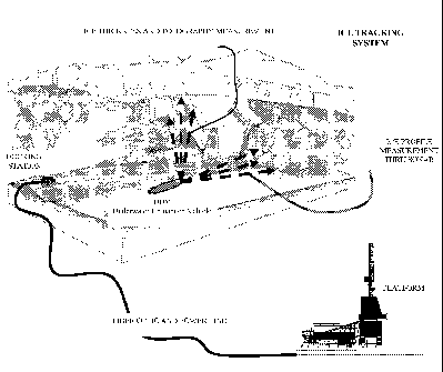
[0016] FIG. 1: Ice Floe Tracking System with Satellites.
[0017] FIG. 2: Under Ice Profile and UUV.
[0018] FIG. 3: Docking Stations and UUVs.
[0019] FIG. 4: Possible Direction "Cones" for ice-floes.
[0020] FIG. 5: Baseline Survey Mission (courtesy of Kongsberg).
DETAILED DESCRIPTION
[0021] Turning now to the detailed description of the preferred arrangement
or arrangements
of the present invention, it should be understood that the inventive features
and concepts may be
4
CA 02772259 2012-02-24
WO 2011/149658 PCT/US2011/035942
manifested in other arrangements and that the scope of the invention is not
limited to the
embodiments described or illustrated. The scope of the invention is intended
only to be limited
by the scope of the claims that follow.
[0022] Underwater Unmanned Vehicles (UUV) also called autonomous underwater
vehicles
(AUV) can be used to image undersea topography across a large area (FIG. 2).
UUVs are
automated micro submarines anywhere from less than a foot to up to 20 feet or
more in length
(some larger UUVs may be 7 to 10 M in length and up to 3 meters in diameter).
UUVs are
battery powered and may have automated obstacle avoidance systems, on-board
positioning
systems, and sonar sensors to measure the time and distance between other UUVs
and the
underwater ice profile. They are automated in the sense that they are given
instructions to follow
a certain trajectory and come back. In one embodiment one or more UUV launch
systems may
be used including from the platform where the operation and drilling take
place; from an ice
breaker, barge or separate control ship that stays in the vicinity of the
platform; or from fixed
docking stations that reside on the sea-floor. Fixed docking stations may be
laid on the sea floor,
they may be tethered to underwater structures, or they may be tethered to the
platform or control
ship.
[0023] Previously UUVs were used to make detailed maps of the seafloor,
construct and
maintain subsea infrastructure including pipelines and sub sea completions in
a cost effective
manner with minimum disruption to the environment. UUVs are available from a
variety of
commercial and private sources including the REMUS 100 UUV from Woods Hole
Oceanographic Institution and Hydroid, Inc.; the HUGIN 1000 and 3000 UUVs from
Kongsberg
Maritime and Norwegian Defence Research Establishment; the Bluefin Robotics 12
and 21 inch
diameter vehicles, ALISTER AUV from ECA HYTECTm and the International
Submarine
Engineering Ltd. Explorer, as well as vehicles by Lockheed-Martin, BlueView
Technologies,
Inc., Autonomous Undersea Systems Institute (AUSI), C & C Technologies,
Cybernetics, and
others. UUVs may be constructed with various radar, sonar, laser, backscatter
and upward
looking systems for visualizing and mapping various underwater environments
dependent upon
available light, depth, water quality, and the weight and size of the UUV.
Batteries may be
developed to reduce the UUV weight or for longevity of the battery. As
batteries improve by
decreasing weight, increasing longevity, increasing the number of recharges
and decreasing
charge time, UUV surveys become longer, faster, and the area covered
increases. UUVs may
CA 02772259 2012-02-24
WO 2011/149658 PCT/US2011/035942
contain a variety of different functions including processors, antennae,
global positioning systems
(GPS), long term and short term data storage, removable media, camera,
avoidance systems,
location systems, echo-locators, homing systems, and the like.
[0024] An "ice floe" is a flat mass of ice floating in a body of water. Ice
floes may include
smaller floating ice structures such as icebergs, individual ice sheets, or
groups of icebergs and
ice sheets. Ice floes may also be larger masses such as ice fields. Ice floes
may be thin sheets of
ice or may be thicker pieces of ice with substantial underwater topography.
Ice floes can vary in
density from loosely packed snow accumulations to large thick sheets of dense
fresh or salt water
ice. Ice floes may originate from glaciers, larger ice fields, first year ice
sheets, multi-year ice
sheets and other ice sources. The identification of ice floes of different
sizes is complicated as
the amount of ice increases. Increasing ice coverage decreases the area
visible to radar, satellite,
and other imaging techniques. As ice coverage limits visibility the danger
posed by large ice
masses increases because reaction time is inhibited and available responses
are restricted. Ice
floe speed may also change the dangers posed by an ice floe. Typically, an ice
floe travels
slowly, exerting pressure due to constant movement and not rapid speed. Ice
floes may not make
detectable movements in packed ice or may move at up to 0.2 knots
(approximately 0.23 mph or
0.37 km/h). In some embodiments an ice floe may move at greater than 0.4 knots
(about 0.5 mph
or 0.74 km/h) dependent upon the ocean currents, winds, shape of the ice floe,
and other
environmental factors.
[0025] Stresses in the ice floe may create different ridging and rafting
patterns that may make
the ice thicker or thinner in different areas. Pressure ridging, shear
ridging, and fracturing may
influence the ice formation and change the rheology of the ice floe. The ice
floe topology must
be analyzed to determine the thickness, density, properties, mass and overall
threat of the ice floe
to drilling structures, ships, ports, and other structures that may be on or
exposed to sea ice. In
FIG. 4 the probabilistic nature of the floe direction at one point in time is
demonstrated. One can
see that some floes can be discarded as they have very little or no
possibility of entering the alert
zone, and will not have sufficient time to impact the structure within the
alert time, while some
have to be tracked continuously because they may possibly or will probably
impact the structure.
Typically satellite imagery can be used to identify ice floes and predict ice
floe movement.
Unfortunately, satellite imagery is inconsistent as satellites are frequently
out of range in the
Northern Arctic and Southern Antarctic regions and there may be gaps where
imagery is
6
CA 02772259 2012-02-24
WO 2011/149658 PCT/US2011/035942
unavailable for several hours or days. The ice floes can be identified from
satellite imagery, the
area of the ice floe can be determined, the direction of travel can be
estimated, and future
trajectories can be predicted. The cones in FIG. 4 show possible ice floe
direction based on
satellite images and travel prediction algorithms. Time zero is set at the end
of the summer when
the first ice floes appear within a circle of 100 nautical miles of the
platform.
[0026] The platform may be one of many different structures including a
variety of drilling
rigs, floating rigs, ship based rigs, jack-up rigs, fueling stations, floating
platforms, docks, ports,
temporary islands, artificial islands, shipping lanes, and the like. The
platform may even contain
multiple different structures that are fixed and floating with or without
access and pipes between
the different structures. Frequently, the platform may include a variety of
vessels and structures
including drilling ships or floating rigs, supply ships, chain ships or
barges, one or more ice
breakers, floating processing ships, ships or barges for drill cuttings and
other wastes, and tankers
to carry produced liquids or gases, as well as ships, platforms and barges
that may serve multiple
functions. Additionally, the barges or ships may be interchanged depending
upon the weather,
water conditions, ice floe dangers, type of well, processes being conducted
and other factors that
influence drilling.
[0027] Platforms are designed to resist a certain mass, thickness and
velocity of ice floe
dependent upon the design of the platform and environmental conditions. If
however the platform
were exposed to pressures above a certain threshold, personnel may be
evacuated, pipelines
flushed or shut down, drilling operations stopped, shutoff valves closed, and
the like, so that no
oil is spilled in the water or on the ice. In the case of jack-up rigs, the
rig may be raised or
lowered dependent upon the size of the approaching ice and danger posed to the
drilling
operations.
[0028] Ice breakers are ships designed to penetrate ice sheets and break up
the ice flow. A
variety of ice breakers are known that can break-up ice of varying thicknesses
and densities.
Dependent upon the type of ice and available ice breakers, one or more ice
breakers may be used
to break up, move or change the direction of the ice floe.
[0029] Zones around the structures may be measured in distance, time, or
probability of
collision. A variety of time, distance or other cautionary domains may be
established either
individually or in overlapping zones. As the risk of collision increases or
the time before
collision decreases, various actions may be undertaken including preventative
actions,
7
CA 02772259 2014-02-24
precautionary actions, shut-down, and evacuation. Zones may include
observation zones, alert
zones, safety zones, scattily zones and the like. In one embodiment, ice floes
above a target sizc
may be identified if they enter the "observation zone." This indicates further
scrutiny where the
ice floe is monitored for direction and speed. Risk of collision may be
assessed after an ice floe
enters the observation zone. The "alert zone" may be set up where specific
responses are
prescribed for ice floes that are identified entering the alert zone. A
"secure zone" may be an
area where actions are to be completed before an ice floe enters the secure
zone.
[0030] Preventative measures, precautionary measures, and other actions may
be undertaken
in response to various positions and directions of ice floe movement.
Preventative measures may
include activation of ice breakers to break-up or move ice floes, ice breaking
buoys may be
deployed, or the rig may be raised or lowered to better withstand the force of
the ice.
Precautionary measures may include shutting off and/or detaching drilling
equipment, closing
shutoff valves, staging for evacuation, and evacuation. Ice gear and safety
equipment may be
deployed if required or if a threat is present.
[0031] The following examples of certain embodiments of the invention are
given. Each
example is provided by way of explanation of the invention, one of many
embodiments of the
invention, and the following examples should not be read to limit, or define,
the scope of the
invention.
Example 1:
[0032] In one embodiment, platform based UUVs are launched when an ice floe
is identified.
If the ice floe has one possible trajectory that may make it hazardous to the
platform, a UUV
launched from the platform. is sent to the remote location where the ice floe
is located. In one
embodiment, a long range UUV may be launched with a radio transmitter. The
U'UV will assess
the size, thickness and direction of the ice floe. Upon completion of the ice
floe survey, the UUV
will then attempt to surface within or near the ice floe of interest, this may
be accomplished by
identifying areas of no ice coverage within the survey area. Once the UUV
surfaces within the
ice floe of interest, it may transmit ice floe information directly to the
platform or to one or more
remote locations like a ship or receiving buoy. Not only will the ice floe
thickness survey be
transmitted via direct radio communication, but the ice floe location can be
tracked with a low
energy beacon. Once the hazardous ice floe has cleared the platform, the UUV
may be retrieved
8
CA 02772259 2012-02-24
WO 2011/149658 PCT/US2011/035942
by an ice breaker or other means. Alternatively, if no surface location is
available, the UUV may
return to the platform to download the survey.
Example 2:
[0033] In another embodiment, ice breakers in service around the platform
to protect it from
the ice also carry one or more UUVs. The UUVs are deployed from the ice
breaker when an ice
floe of interest is identified. In one embodiment, one ice breaker may be
designated for ice floe
management. The ice breaker is deployed to a distant location once the ice
floe is identified. The
UUV is released from that location and intercepts the ice floe. Once the ice
floe is surveyed the
UUV may return to the ice breaker. In one embodiment an underwater signal is
used as a beacon
to draw the UUV back to the ice breaker. In another embodiment, the UUV
returns to a
predetermined location to await retrieval. In yet another embodiment, the ice
breaker may return
to the UUV launch site for retrieval. The UUV may be launched and retrieved
from any number
of shipboard methods including moonpools, booms, winches, towed docking
stations, or simply
by tow line.
[0034] Additionally, one or more ice breakers may be used for each survey.
Each ice breaker
may carry, launch and recover numerous UUVs. In one embodiment the ice breaker
may carry 5
UUVs. In another embodiment a variety of ice breakers carry one or two UUVs
for launch. The
UUVs may be later retrieved by one or more retrieval boats. The number of
UUVs, the number
of Tracking Stations and the location of Tracking Stations, may be determined
based on the
average speed of the ice floe, distance of ice breaker travel, distance of UUV
travel and life span
of the UUV battery. Remote tracking stations, either on ice breakers, at land
masses, or fixed
positions in the water may be deployed to increase UUV distance and retrieval.
Tracking stations
may also be used to define or modify UUV trajectories before they are launched
or during a
survey. Tracking stations may be used to triangulate UUV position, ice breaker
position,
platform position, and provide "safe" returns if UUV retrieval is disrupted.
Ice breaker and UUV
trajectory, including drop off and pick up, are optimized to cover as much as
an area as possible,
reduce the time of survey, and reduce the distance travelled.
Example 3:
[0035] In another embodiment, docking stations are fixed on the sea bed.
The docking
system may be connected to the platform and can include a power source, data
transmission
wires, fiber optic systems, pressure sensors and the like. One or more UUVs
may dock at a
9
CA 02772259 2012-02-24
WO 2011/149658 PCT/US2011/035942
docking station for recharging, data download, or for "sleep" between surveys.
UUVs are
programmed to download the data they have stored on their memory and upload
power to the
batteries when docked as well as receive and transmit instructions,
conditions, diagnostic
information and the like. UUVs are programmed so that they "remember" where
the docking
stations are located and travel to the docking station if at any time
communications are disrupted,
the survey is unable to be completed, battery life is low, damage occurs, or
other factors interfere
with normal operations.. FIG. 3 demonstrates one possible scenario of the
location of the
docking stations and the trajectory of the UUVs. Docking stations may be
located at a specific
distance from the platform or at locations based on terrain. In one embodiment
docking stations
are located at approximately 10 miles from the platform structure. In another
embodiment an
outer position is maintained by an ice management station, boat, or ice
breaker allowing location
of the docking station up to 100 miles in from the platform. The docking
station may also be
located close to the platform, thus reducing the length of communication and
power lines.
Inversely, the docking station may be located off of a remote island,
peninsula or other land
based feature. Because ice floes may move in different directions and speeds,
docking stations
may be placed asymmetrically. In one embodiment, UUV docking stations would be
placed in
the prevailing current at 10 to 40 miles from the platform, while short range
docking stations may
be placed at 1 to 10 miles from the platform on sides where the prevailing
current will not drive
the ice floe rapidly into the platform. Frequently, the ice floes must still
be monitored on all sides
of the platform due to the unpredictable nature of ice floe trajectory,
localized currents, changes
in wind direction, and other environmental factors. In one embodiment several
docking stations
are mounted on the sea floor 80 miles from the platform. At each docking
station up to 5 UUVs
are stationed with separate loading sites for each UUV such that all 5 UUVs
may be docked at
the same time. Then, once an ice floe of interest is identified via satellite,
radar, or other survey,
one or more UUVs are dispatched to assess the underwater topology, thickness
and other ice floe
parameters. The UUV collects upward looking sonar data from under the ice floe
as shown in
FIG. 5. Once the ice floe has been surveyed, the UUV returns to the docking
station where the
survey is downloaded and transmitted to either the platform or an ice
management ship for
analysis. The ice floe is then classified as "not relevant," "of interest," or
"hazardous" depending
upon mass and rheology. If the ice floe is "of interest" or "hazardous" it may
be monitored by
CA 02772259 2014-02-24
one or more UUVs or it may be addressed by dispatching one or more ice
breakers to influence
the direction of the ice floe or break up the ice floc.
TABLE 1: Ice floe travel distance vs ice floe speed in knots.
Hours
Knots 1 12 24 48 72
0.1 0.115 1.38 2.76 5.52 8.28
0.2 0.23 2.76 5.52 11.04 16.56
0.3 0.345 4.14 8.28 16.58 24.84
0.5 0.575 6.9 13.8 27.6 41.4
0.75 0.8625 10.36 20.7 41.4 62.1
1 1.15 13.8 27.6 55.2 82.8
[0036] in Table 1,
ice floe distance is displayed in relation to ice floe speed in knots. This
indicates that an ice floe traveling at 0.5 knots would have to be observed at
approximately 40
miles to initiate a 72 hr shut down and evacuation. The average ice floe
travels at approximately
0.25 knots, indicating that a 20 mile warning radius should be sufficient for
most ice floes. A
maximum speed of about 1 knot has been seen in ice floes and some may move
faster under
harsh weather conditions or if both wind and current simultaneously move the
ice floe in the
same direction.
[0037] Alternatively, one or more UUVs may be
dispatched at all times to monitor ice floe
movement. This is done to prevent unforeseen ice floc hazards. If the ice
flocs are monitored at
80 miles out, then the platform has up to 72 hours to respond to the fastest
moving ice floes. This
can be done by sending out UUVs to identify ice floes that reach below a
certain depth with a
range of the underwater docking station. The UUV can then report the ice floe
at the end of
screening a large area or upon contact with a larger ice floe. Upon return,
one or more UUVs
may be deployed to survey ice floes of interest to assess if the ice floe is a
hazard, track ice floe
movement and determine putative ice floe trajectories. The UUVs may be
deployed in a variety
of arrays dependent upon terrain, prevailing currents, prevailing winds,
amount of ice pack,
maximum speed of ice floes in the region, average speed of ice floes in the
region, availability of
other warning systems, platform location and platform type, as well as other
factors that may
affect the hazards presented by undetected ice floe movement.
[0038] In closing,
it should be noted that the discussion of any reference is not an admission
that it is prior art to the present invention, especially any reference that
may have a publication
date after the priority date of this application.
CA 02772259 2014-02-24
[0039] Although the systems and processes described herein have been
described in detail, it
should be understood that various changes, substitutions, and alterations can
be made. Those
skilled in the art may be able to study the preferred embodiments and identify
other ways to
practice the invention that are not exactly as described herein. It is the
intent of the inventors that
variations and equivalents of the invention are within the scope of the claims
while the
description, abstract and drawings are not to be used to limit the scope of
the invention. The
invention is specifically intended to be as broad as the claims below and
their equivalents.
REFERENCES
[0040] The discussion of any reference is not an admission that it is prior
art to the
present invention, especially any reference that may have a publication data
after the
priority date of this application.
1. US5122990, "Bottom Tracking System," Rowe-Deines Instr. Inc, Inv.: Deines
(2/91).
2. US5381694, "Ice Thickness Measurement Reflectometer," Dedicated
Electronics, Inv.: Glynn
(9/92).
3. US5585799, "Microwave doppler radar system for detection and kinematic
measurements of
river ice," USA Dept. of Army, Inv.: Yanlrielun, (6/95).
4. US6700528, US2003034912, "Motion detection and alerting system," USA Dept.
of Army,
Inv.: Williams, (9/02).
5. US7095359, US2004143395, W003048803, "Method of observing sea ice," Nat
Inst Inf &
Comm Tech, ,Inv.: Matsuoka (11/01).
6. GB2223642, "Tracking sea ice," Marconi Geo Ltd, Inv.: Johnson (10/88).
7. Harrns, et al., "AWI moored ULS data, Weddell Sea (1990-1998)." Boulder,
CO: National
Snow and Ice Data Center/World Data Center for Glaciology (2001).
8. Hyatt, et al., "Estimating sea-ice coverage, draft, and velocity in
Marguerite Bay (Antarctica)
using a subsurface moored upward-looking acoustic Doppler current profiler
(ADCP)," Deep
Sea Research Part II: Topical Studies in Oceanography, 55:351-64 (2008).
http://dx.doi.org/10.1016/j.dsr2.2007.11.004
9. Strass, "Measuring sea ice draft and coverage with moored Upward Looking
Sonars," Deep-
Sea Res, I 45:795-818 (1998). doi:10.1016/S0967-0637(97)00065-4
10. Theriault, et al.,. "Survey of Active Acoustic Monitoring (AAM)
Technologies." Int'l Assoc.
Oil & Gas Prod_ (OGP) 1: (2009).
11. Wadhams, et al., "A new view of the underside of Arctic sea ice," Geophys.
Res. Lett., 33,
L04501, doi:10.1029/2005GL025131. (2006).
12