Note: Descriptions are shown in the official language in which they were submitted.
CA 2775561 2017-03-21
MIGRATION-BASED ILLUMINATION
DETERMINATION FOR AVA RISK ASSESSMENT
[0001] Technical Field
[0002] This invention relates to the general subject of seismic exploration
and, in
particular, to methods for estimating seismic and other signals that are
representative of the
subsurface in areas of complex subsurface structure.
Background Of The Invention
100031 A seismic survey represents an attempt to image or map the
subsurface of the
earth by sending sound energy down into the ground and recording the "echoes"
that return
from the rock layers below. The source of the down-going sound energy might
come, for
example, from explosions or seismic vibrators on land, or air guns in marine
environments.
During a seismic survey, the energy source is placed at various locations near
the surface of
the earth above a geologic structure of interest. Each time the source is
activated, it generates
a seismic signal that travels downward through the earth, is reflected, and,
upon its return, is
recorded at a great many locations on the surface. Multiple source / recording
combinations
are then combined to create a near continuous profile of the subsurface that
can extend for
many miles. In a two-dimensional (2D) seismic survey, the recording locations
are generally
laid out along a single line, whereas in a three dimensional (3D) survey the
recording
locations are distributed across the surface in a grid pattern. In simplest
terms, a 2D seismic
1
CA 2775561 2017-03-21
line can be thought of as giving a cross sectional picture (vertical slice) of
the earth layers as
they exist directly beneath the recording locations. A 3D survey produces a
data "cube" or
volume that is, at least conceptually, a 3D picture of the subsurface that
lies beneath the
survey area. In reality, though, both 2D and 3D surveys interrogate some
volume of earth
lying beneath the area covered by the survey.
[0004] A seismic
survey is composed of a very large number of individual seismic
recordings or traces. In a typical 2D survey, there will usually be several
tens of thousands of
traces, whereas in a 3D survey the number of individual traces may run into
the multiple
millions of traces. Chapter 1, pages 9 ¨ 89, of Seismic Data Processing by
Ozdogan Yilmaz,
Society of Exploration Geophysicists, 1987, contains general information
relating to
conventional 2D processing. General
background information pertaining to 3D data acquisition and processing may be
found in
Chapter 6, pages 384-427, of Yilmaz .
[0005] A seismic
trace is a digital recording of the acoustic energy reflecting from
inhomogeneities or discontinuities in the subsurface, a partial reflection
occurring each time
there is a change in the elastic properties of the subsurface materials. The
digital samples are
usually acquired at 0.002 second (2 millisecond or "ms") intervals, although 4
millisecond
and 1 millisecond sampling intervals are also common. Each discrete sample in
a
conventional digital seismic trace is associated with a discrete sampling of
the reflected
acoustic wavefield in time. Many variations of the conventional source-
receiver arrangement
are used in practice, e.g. VSP (vertical seismic profiles) surveys, ocean
bottom surveys, etc.
Further, the surface location of every trace in a seismic survey is carefully
tracked and is
generally made a part of the trace itself (as part of the trace header
information). This allows
the seismic information contained within the traces to be later correlated
with specific surface
2
CA 02775561 2012-03-27
WO 2011/041782 PCT/US2010/051321
and subsurface locations, thereby providing a means for posting and contouring
seismic data
¨ and attributes extracted therefrom ¨ on a map (i.e., "mapping").
[0006] The data in a 3D survey are amenable to viewing in a number of
different
ways. First, horizontal "constant time slices" may be taken extracted from a
stacked or
unstacked seismic volume by collecting all of the digital samples that reflect
from a given
subsurface location after correcting these samples for the effects of acoustic
propagation.
This operation results in a horizontal 2D plane of seismic data. By animating
a series of 2D
planes it is possible for the interpreter to pan through the volume, giving
the impression that
successive layers are being stripped away so that the information that lies
underneath may be
observed. Similarly, a vertical plane of seismic data may be taken at an
arbitrary azimuth
through the volume by collecting and displaying the seismic traces that lie
along a particular
line. This operation, in effect, extracts an individual 2D seismic line from
within the 3D data
volume. It should also be noted that a 3D dataset can be thought of as being
made up of a 5D
data set that has been reduced in dimensionality by stacking it into a 3D
image. The
dimensions are typically time (or depth "z"), "x" (e.g., North-South), "y"
(e.g., East-West),
source-receiver offset in the x direction, and source-receiver offset in the y
direction. While
the examples here may focus on the 2D and 3D cases, the extension of the
process to four or
five dimensions is straightforward.
[0007] Seismic data that have been properly acquired and processed can
provide a
wealth of information to the explorationist, one of the individuals within an
oil company
whose job it is to locate potential drilling sites. For example, a seismic
profile gives the
explorationist a broad view of the subsurface structure of the rock layers and
often reveals
important features associated with the entrapment and storage of hydrocarbons
such as faults,
folds, anticlines, unconformities, and sub-surface salt domes and reefs, among
many others.
During the computer processing of seismic data, estimates of subsurface rock
velocities are
3
CA 2775561 2017-03-21
routinely generated and near surface inhomogeneities are detected and
displayed. In some
cases, seismic data can be used to directly estimate rock porosity, water
saturation, and
hydrocarbon content. Less obviously, seismic waveform attributes such as
phase, peak
amplitude, peak-to-trough ratio, and a host of others, can often be
empirically correlated with
known hydrocarbon occurrences and that correlation applied to seismic data
collected over
new exploration targets.
[0008] Many
variations of the conventional source-receiver arrangement are used in
practice, e.g. VSP (vertical seismic profile) surveys, ocean bottom surveys,
etc.
[0009] Seismic
attributes such as amplitude versus offset ("AVO") or amplitude
versus angle of incidence ("AVA") analyses can yield important information
about the
contents of subsurface rock formations. Although hydrocarbons cannot generally
be viewed
directly in the subsurface using seismic, variations in reflectivity with
angle of incidence have
been increasingly used as an attribute or indicator of the presence of
subsurface gas. See, for
example, Castagna and Swan, "Principles of AVO Crossplotting", The Leading
Edge, April
1997. However,
deeper targets
pose a number of problems for this technology, not the least of which is
related to the
distortion that may be introduced by the subsurface structure and/or the
processing methods
that are used to image that structure.
10010] One of the key
aspects in the continuing development of these areas of complex
geology is well planning, which often must be done in geologic settings where
obtaining
good seismic images can be a challenge. Since AVA is often used to assess the
potential for
well location, any irregularities in AVA response due to uneven acoustic
illumination
resulting from complex overburden introduces substantial risk in AVA analysis
and could
very well adversely effect well placement.
4
CA 02775561 2012-03-27
WO 2011/041782 PCT/US2010/051321
[0011] Subsurface imaging in regions of complex structure is problematic
because the
seismic wavefield may be distorted significantly as it passes through such
complexity. Of
particular interest for purpose of the instant disclosure is imaging in the
presence of
subsurface salt. Seismic surveys that include subsurface salt features (e.g.,
salt domes) can
produce data that is marred by uneven illumination of the reflectors below the
salt (or other
structure). This in turn, can cause AVA-type analyses to be difficult to
interpret and/or
simply unreliable. In the case of a salt dome, the distortion in the wavefield
is caused by the
large velocity contrast between salt and the surrounding rock (i.e., salt
typically has a seismic
velocity that is much higher than that of the surrounding sedimentary rocks).
This velocity
contrast results in large amounts of ray bending and rays that are normal to
the target reflector
will tend to go critical at the sediment salt interface. Conventional seismic
imaging methods
do not properly compensate for this uneven illumination, which can distort the
observed trace
amplitudes and can render AVO/AVA analysis unreliable.
100121 Thus, what is needed is a method of compensating seismic gathers
for
illumination irregularities caused by structure, the effects of the
acquisition footprint, and
wave propagation effects in complex structural areas while simultaneously
preserving the
AVA reflectivity signature.
[0013] Heretofore, as is well known in the seismic processing and seismic
interpretation arts, there has been a need for a method of obtaining better
estimates of the
AVA effect in areas with a complex geological subsurface structure.
Accordingly, it should
now be recognized, as was recognized by the present inventor, that there
exists, and has
existed for some time, a very real need for a method of seismic data
processing that would
address and solve the above-described problems.
[0014] Before proceeding to a description of the present invention,
however, it should
be noted and remembered that the description of the invention which follows,
together with
CA 02775561 2012-03-27
WO 2011/041782 PCT/US2010/051321
the accompanying drawings, should not be construed as limiting the invention
to the
examples (or preferred embodiments) shown and described. This is so because
those skilled
in the art to which the invention pertains will be able to devise other forms
of this invention
within the ambit of the appended claims.
6
CA 2775561 2017-03-21
Summary of The Invention
[0015] According to a preferred aspect of the instant invention, there is
provided
herein a system and method for extending zero-offset or stacked wave-equation
illumination
analysis into the angle-gather domain, where it becomes an effective tool for
assessing the
effects of complex overburden on AVA response. A preferred method for doing
this involves
first creating an angle gather (see, e.g., USPN 4,646,239),
that has a perfect AVA response (i.e., a constant amplitude as a
function of angle).
[0016] This gather is then preferably used as a reflectivity map that is
used in a
demigration or modeling process the output from which is modeled data that, by
construction,
carries with it a completely flat reflectivity signature. "Demigration" is a
process by which a
depth migrated data set is used to calculate an estimate of an original common-
offset section
from which it could have been obtained. Note that for purposes of the instant
disclosure, the
terms "modeling" and "unit reflector modeling" should be understood to be a
process by
which a synthetic seismic data set is produced from a model of the earth
carries a flat
reflectivity signature (i.e., one in which there is no variation in reflection
amplitude with
changing angle of incidence).
[0017] Note that this definition should be broadly construed to include the
sort of unit
amplitude reflector discussed above, as well as model are generated that where
density
reflectors are used in acoustic two-way time modeling.
[0018] Those of ordinary skill in the art will recognize that the adjoint
of the
migration operator can be defined as demigration. Of course, the demigration
operation can
be used to convert a depth migrated section to a time domain data set that
approximates the
original acquired data.
7
CA 02775561 2012-03-27
WO 2011/041782 PCT/US2010/051321
100191 Thus, remigration of a demigrated or modeled data set produced
according to
the instant invention then produces a gather on which any amplitude variation
is more likely
to be a measure of illumination effects alone. The resulting AVA signature on
the gather can
then be used to help distinguish whether amplitude variation on the angle
gathers is due to
illumination effects during propagation, or actual rock properties. This
approach also
preferably produces an AVA confidence analysis which can help the
explorationist determine
when AVA signatures are relatively free from illumination effects.
[0020] The foregoing has outlined in broad terms the more important
features of the
invention disclosed herein so that the detailed description that follows may
be more clearly
understood, and so that the contribution of the instant inventor to the art
may be better
appreciated. The instant invention is not to be limited in its application to
the details of the
construction and to the arrangements of the components set forth in the
following description
or illustrated in the drawings. Rather, the invention is capable of other
embodiments and of
being practiced and carried out in various other ways not specifically
enumerated herein.
Finally, it should be understood that the phraseology and terminology employed
herein are
for the purpose of description and should not be regarded as limiting, unless
the specification
specifically so limits the invention.
8
CA 02775561 2012-03-27
WO 2011/041782 PCT/US2010/051321
Brief Description of the Drawings
[0021] Other objects and advantages of the invention will become apparent
upon
reading the following detailed description and upon reference to the drawings
in which:
[0022] Figure 1 illustrates the general environment of the instant
invention.
[0023] Figure 2 illustrates a seismic processing sequence suitable for use
with the
instant invention.
[0024] Figure 3 contains a schematic illustration of how the instant
invention might
be used in an exploration setting.
[0025] Figure 4 a preferred operating logic suitable for use with the
instant invention.
[0026] Figure 5 a continuation of the preferred operating logic from Figure
4 with
additional details regarding the back projection loop.
[0027] Figures 6A-6C contain a schematic representation of the migration /
demigration / modeling process of the instant invention.
9
CA 02775561 2012-03-27
WO 2011/041782 PCT/US2010/051321
DETAILED DESCRIPTION
[0028] While this invention is susceptible of embodiment in many different
forms,
there is shown in the drawings, and will herein be described hereinafter in
detail, some
specific embodiments of the instant invention. It should be understood,
however, that the
present disclosure is to be considered an exemplification of the principles of
the invention
and is not intended to limit the invention to the specific embodiments or
algorithms so
described.
GENERAL ENVIRONMENT OF THE INVENTION
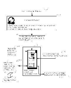
[0029] Figure 1 illustrates the general environment in which the instant
invention
would typically be used. A seismic survey is designed 110 by the
explorationist to cover an
area of economic interest. Field acquisition parameters (e.g., shot spacing,
line spacing, fold,
etc.) are typically selected in conjunction with this step, although it is
common to modify the
ideal design parameters slightly (or substantially) in the field to
accommodate the realities of
conducting the survey.
[0030] Seismic data arc collected in the field 120 over a subsurface target
of potential
economic importance and are typically sent thereafter to a processing center
150 where they
will be processed for use in exploration. In some cases, there may be some
initial data
processing performed in the field and this is becoming more common and
feasible given the
computing power that is available to field crews.
[0031] In the processing center a variety of preparatory processes 130 are
applied to
the seismic traces to make them ready for use by the methods disclosed
hereinafter. The
processed traces would then be made available for use by the instant invention
and might be
stored, by way of example only, on hard disk, magnetic tape, magneto-optical
disk, DVD
disk, or other mass storage means.
CA 02775561 2012-03-27
WO 2011/041782 PCT/US2010/051321
100321 The methods disclosed herein would best be implemented in the form
of a
computer program 140 that has been loaded onto a general purpose programmable
computer
150 where it is accessible by a seismic interpreter or processor. Note that a
general purpose
computer 150 would typically include, in addition to mainframes and
workstations,
computers that provide for parallel and massively parallel computations,
wherein the
computational load is distributed between two or more processors. As is also
illustrated in
Figure 1, in the preferred arrangement some sort of digitized zone of interest
model 160 may
be specified by the user and provided as input to the processing computer
program. In the
case of a 3D seismic section, the zone of interest model 160 would typically
include specifics
as to the lateral extent and thickness (which might be variable and could be
measured in time,
depth, frequency, etc.) of a subsurface target. The exact means by which such
zones are
created, picked, digitized, stored, and later read during program execution is
unimportant to
the instant invention and those skilled in the art will recognize that this
might be done any
number of ways.
[0033] A program 140 embodying the instant invention might be conveyed into
the
computer that is to execute it by means of, for example, a floppy disk, a
magnetic disk, a
magnetic tape, a magneto-optical disk, an optical disk, a CD-ROM, a DVD disk,
a RAM
card, flash RAM, a RAM card, a PROM chip, or loaded over a network. In a
typical seismic
processing environment, the methods of the instant invention would be made
part of a larger
package of software modules that is designed to perform many of the processing
steps listed
in Figure 2. After processing by the instant methods, the resulting traces
would then typically
be sorted into gathers, stacked, and displayed either at a high resolution
color computer
monitor 170 or in hard-copy form as a printed seismic section or a map 180.
The seismic
interpreter would then use the displayed images to assist him or her in
identifying subsurface
features conducive to the generation, migration, or accumulation of
hydrocarbons.
11
CA 02775561 2012-03-27
WO 2011/041782 PCT/US2010/051321
[0034] As was indicated previously, the instant invention will preferably
be made a
part of and incorporated into a conventional seismic processing sequence of
the sort generally
described in Figure 2. Those of ordinary skill in the art will recognize that
the processing
steps illustrated in Figure 2 are only broadly representative of the sorts of
processes that
might be applied to such data and the choice and order of the processing
steps, and the
particular algorithms involved, may vary markedly depending on the individual
seismic
processor, the signal source (dynamite, vibrator, etc.), the survey location
(land, sea, etc.) of
the data, the company that processes the data, etc.
[0035] As a first step, and as is generally illustrated in Figure 2, a 2D
or 3D seismic
survey is conducted over a particular volume of the earth's subsurface (step
210). The data
collected in the field consist of unstacked (i.e., unsummed) seismic traces
which contain
digital information representative of the volume of the earth lying beneath
the survey.
Methods by which such data are obtained and processed into a form suitable for
use by
seismic processors and interpreters are well known to those of ordinary skill
in the art.
[0036] The purpose of a seismic survey is to acquire a collection of
spatially related
seismic traces over a subsurface target of some potential economic importance.
Data that are
suitable for analysis by the methods disclosed herein might consist of, for
purposes of
illustration only, an unstacked 2-D seismic line, an unstacked 2-D seismic
line extracted from
a 3D seismic survey or, preferably, an unstacked 3D portion of a 3D seismic
survey, or a 4D
or 5D survey, etc. The invention disclosed herein is most effective when
applied to a group
of seismic traces that have an underlying spatial relationship with respect to
some subsurface
geological feature. Again for purposes of illustration only, the discussion
that follows will be
couched in terms of traces contained within a 3-D survey (stacked or unstacked
as the
discussion warrants), although any assembled group of spatially related
seismic traces could
conceivably be used.
12
CA 02775561 2012-03-27
WO 2011/041782 PCT/US2010/051321
[0037] After the seismic data are acquired (step 210), they are typically
taken to a
processing center where some initial or preparatory processing steps are
applied to them. As
is illustrated in Figure 2, a common early step 215 is designed to edit the
input seismic data in
preparation for subsequent processing (e.g., demux, gain recovery, wavelet
shaping, bad trace
removal, etc.). This might be followed by specification of the geometry of the
survey (step
220) and storing of a shot / receiver number and a surface location as part of
each seismic
trace header. Once the geometry has been specified, it is customary to perform
a velocity
analysis consisting of NMO analysis if the processing is time processing, or
NMO followed
by RMS to interval velocity conversion followed by depth migration and
tomography to
obtain an initial velocity model for depth migration.
[0038] After the initial pre-stack processing is completed, it is customary
to condition
the seismic signal on the unstacked seismic traces before creating stacked (or
summed) data
volumes (step 230). In Figure 2 step 230 contains a typical "Signal Processing
/ Conditioning
/ Imaging" processing sequence, but those skilled in the art will recognize
that many
alternative processes could be used in place of the ones listed in the figure.
In any case, the
ultimate goal from the standpoint of the explorationist is the production of a
seismic volume
or, in the case of 2D data, a seismic line for use in the exploration for
hydrocarbons within
the subsurface of the earth.
[0039] In some preferred arrangements, the instant invention might best be
utilized in
connection with step 230. That being said, those of ordinary skill in the art
will recognize
that there are many other points in a typical processing sequence that could
be improved
through the use of the instant invention.
100401 As is further suggested in Figure 2, any digital sample within a
seismic
volume is uniquely identified by a (X, Y, OFFSETX,OFFSETY,TIME) vector, with
the X
and Y coordinates representing some position on the surface of the earth, the
OFFSETX and
13
CA 02775561 2012-03-27
WO 2011/041782 PCT/US2010/051321
OFFSETY coordinates specifying the distance between source and receiver, and
the time
coordinate measuring a recorded arrival time within the seismic trace (step
240). For
purposes of specificity, it will be assumed that the X direction corresponds
to the "in-line"
direction, and the Y measurement corresponds to the "cross-line" direction, as
the terms "in-
line" and -cross-line" are generally understood in the art. Although time is a
preferred and
most common vertical axis unit, those skilled in the art understand that other
units are
certainly possible might include, for example, depth or frequency.
Additionally, it is well
known to those skilled in the art that it is possible to convert seismic
traces from one axis unit
(e.g., time) to another (e.g., depth) using standard mathematical conversion
techniques. In
addition, depending on whether the volume is imaged or unimaged, a sample in
the volume
may be determined by surface offset (i.e. OFFSETX and OFFSETY) if the volume
is
unimaged or imaged in the form of offset gathers, or alternatively by
reflection opening angle
and azimuth, if the volume is imaged in the form of angle-gathers.
100411 After stacking of an image volume, the explorationist may do an
initial
interpretation 250 of the resulting stacked volume, wherein he or she locates
and identifies
the principal reflectors and faults wherever they occur in the data set. This
might be followed
by additional data enhancement 260 of the stacked or unstacked seismic data
and/or attribute
generation (step 270) therefrom. In many cases the explorationist will revisit
his or her
original interpretation in light of the additional information obtained from
the data
enhancement and attribute generation steps (step 280). As a final step, the
explorationist will
typically use information gleaned from the seismic data together with other
sorts of data
(magnetic surveys, gravity surveys, LANDSAT data, regional geological studies,
well logs,
well cores, etc.) to locate subsurface structural or stratigraphic features
conducive to the
generation, accumulation, or migration of hydrocarbons (i.e., prospect
generation 290).
14
CA 02775561 2012-03-27
WO 2011/041782 PCT/US2010/051321
PREFERRED EMBODIMENTS
100421 According to a first preferred aspect of the instant invention,
there is provided
a system and method for extending zero-offset or stacked wave-equation
illumination
analysis into the angle-gather domain, where it becomes an appropriate tool
for assessing the
effects of complex overburden on AVA response. A preferred method for doing
this involves
first creating an angle gather that has a perfect AVA response (i.e., a
response where the
reflected seismic events have a constant amplitude as a function of angle of
incidence with
respect to the subsurface layers). This "perfect" gather will then preferably
be used as a
reflectivity map in a demigration or modeling process which creates modeled
data that, by
construction, carries with it a completely flatAVA response. Remigration of
such a data set
will then result in a gather on which any amplitude variation is more likely
to be a measure of
illumination effects alone. The resulting AVA signature on the gather can then
be used to
assess the validity of the AVA response on modeled or actual data, resulting
in a useful AVA
risk analysis.
[0043] By way of general background, the amount of seismic energy that is
reflected
from a subsurface reflector at a subcritical angle varies depending (at least
in part) on its
angle of incidence with respect to the reflector. Further, the magnitude of
this effect is much
more pronounced at the interface between a formation that contains gas and
another that does
not. This effect has made it possible to use AVA techniques to estimate
subsurface elastic
parameters from seismic data. Thus, it is customary to include this effect in
synthetic seismic
traces that are produced by conventional modeling programs. However, it should
be noted
that the instant method specifically excludes such computations in the
formation of its
modeled seismic traces.
CA 02775561 2012-03-27
WO 2011/041782 PCT/US2010/051321
100441 The preferred embodiment of the instant invention may be generally
understood as follows. Assume that the observed seismic data may be
represented by the
familiar conceptual equation
Seismic Data = forward propagation * reflectivity,
or
D = FR.
Conceptually, the operator F represents all the effects of actual propagation
through the earth.
In the common practice of imaging of seismic data, this operator cannot be
found directly,
and is instead approximated with a simpler modeling operator M so that
D ¨ MR.
It is common to then make a second approximation to obtain a seismic image.
Because the
operator M cannot be easily inverted, the seismic image is often obtained by
applying the
adjoint M* of the operator M instead of its inverse. Those of ordinary skill
in the art will
recognize that the "adjoint" of a square matrix is defined to be its conjugate
transpose. In
general, the process of migration may be thought of as the process of applying
the adjoint
operator M* to the seismic data.
100451 Given the foregoing, the process of migration to obtain an image of
the
subsurface reflectivity may be written as:
I =
In order to improve on this approximation, one approach would be to treat the
problem as a
least squares problem instead of using the operator M* to migrate the data.
Using this
approach, an improved migration will be obtained:
I = (IVI'Mf1M'D
16
CA 02775561 2012-03-27
WO 2011/041782 PCT/US2010/051321
[0046] Thus, what is needed is a means for computing the inverse of /1r/1/.
The
inverse of M*M contains combined information about illumination at all dips
and opening
angles as well as migration resolution and amplitude fidelity. Additionally,
if augmented
with the acquisition geometry, it contains information regarding the
acquisition footprint.
[0047] The quantity M*M contains information related to three aspects of
recorded
seismic data, i.e., illumination, imaging amplitude fidelity, and acquisition
footprint.
However, for simplicity the term "illumination information" will be used
herein to refer to all
three types of information. Note that, even if the operator (M*M) were known
in its entirety,
calculating its inverse would be expensive in terms of computational resources
and, thus,
disfavored in most instances.
[0048] M will be referred to herein as a demigration operator, since M*
represents a
migration operator. A brute force approach to finding (M*M) is a difficult one
since the
matrices involved are a quite large (e.g. nxnenynenh*nt*nx*ny*nz elements
where nxm is
the number of trace midpoint locations in the x direction, nym is the number
of trace locations
in the y direction, nh is the number of offsets in a narrow azimuth geometry,
nt is the number
of time samples, and (nx,ny,nz) are the dimensions of the reflectivity model).
[0049] As a consequence, the following techniques will preferably be
employed to
implement the instant method.
[0050] An approximation to (M*M) may be obtained by applying this operator
to
appropriate unit-amplitude subsets of the reflectivity model. The illumination
footprint
information obtained in this way depends on the nature of the data set used.
The end product
is obtained from the demigrated/remigrated data set is an opening-angle
gather, obtained
either directly from the migration process, or via slant stacking in the case
of a migration
process that outputs subsurface-offset gathers. An alternative product is a
surface-offset
gather for in the case of a migration that outputs surface offset gathers.
Those of ordinary
17
CA 02775561 2012-03-27
WO 2011/041782 PCT/US2010/051321
skill in the art will recognize that a -slant stack" (radon transform, tau-p
transform, etc.) is a
method of seismic plane wave decomposition. It can be calculated by applying a
series of
linear moveouts to an unstacked seismic gather and summing each moveout over
offset. Of
course, there are more computationally efficient means of calculating the
slant stack than the
brute-force shift / sum and those of ordinary skill in the art will be
familiar with same.
[0051] By way of explanation, suppose a single sample of unit amplitude
representing
a point diffractor is placed at some location (x,y,z h) in the reflectivity
model as a function of
the three spatial (x,y,z) and one subsurface offset (h) dimension, and is then
demigrated and
remigrated (i.e., the operator (M*M) is applied). By using this approach,
illumination
information is obtained for all dips and opening angles, since the slant-stack
of a point
diffractor in all dimensions (x,y,z, h) generates the dip and opening angle
components of the
point diffractor.
[0052] In the preferred embodiment, a method of AVA confidence mapping is
taught.
According to this embodiment, illumination information as a function of
opening angle is
obtained by extending the point diffractor discussed previously to form a
surface embedded
in the (xyz) reflectivity volume. So, if, for example, the point diffractor is
replaced with a
planar surface of a given inline and crossline dip, but remains a point
diffractor located at
zero offset in the subsurface offset direction, the effect of extending the
object into a plane in
(x,y,z) amounts to the selection of illumination information for a single
slant-stack
component, or a single dip, in (x,y,z) reflectivity space. Since the input
data set is still a point
diffractor in the subsurface offset direction, however, illumination for all
opening angles are
retained. If this planar surface is now deformed to follow geologic structure,
it follows that
the illumination information derived will be opening angle illumination
information specific
to the actual geologic structure. In another preferred embodiment, density
reflectors of
appropriate amplitude are placed in the subsurface in a density model to be
used in two-way
18
CA 02775561 2012-03-27
WO 2011/041782 PCT/US2010/051321
acoustic or elastic modeling. Forward modeling is then performed, and the
resulting data is
then migrated to form angle gathers, either directly, or via slant stacking as
indicated above.
[0053] As is generally suggested in Figures 6A, 6B, and 6C, the instant
invention
preferably begins by creating a subsurface reflectivity or density/velocity
model. As
described in the previous section, a reflectivity or density surface that
follows the interpreted
structure will preferably be created in (x,y,z) space The model will then be
demigrated, or
forward modeling will be applied to the model to generated modeled data
(Figure 6B)
according to methods well known to those of ordinary skill in the art and then
remigrated into
the subsurface (Figure 6C) to form an angle gather. This data set results in
illumination
information as a function of opening angle. The information used in the
demigration or
modeling process corresponds to a "perfect" angle gather, e.g. a gather with
no amplitude
imprint as a function of opening angle (i.e., angle of incidence). After
remigration, the
resulting amplitude imprint on the angle gather will thus be a function of
varying illumination
due to propagation through complex structure, the amplitude treatment of the
migration
algorithm itself, and the acquisition footprint.
[0054] The preferred embodiment described above is appropriate for those
migration
processes that naturally produce subsurface offset gathers, such as wave
equation migration,
or migrations which produce angle gathers directly For other imaging
algorithms such as
Kirchhoff migration, the preferred output is a gather in which each surface
vector offset range
is imaged independently, resulting in a gather whose traces represent
independent images
from each vector offset, or an "offset" as opposed to an "angle" gather. For
this type of
imaging process, the input reflectivity will preferably be chosen to be the
geologic surface of
unit amplitude in (xyz) reflectivity space. The preferred embodiment of the
invention is to
then demigrate and remigrate this input reflectivity to each vector offset
independently.
Amplitude variation across the resulting gather is then a direct indication of
illumination
19
CA 02775561 2012-03-27
WO 2011/041782 PCT/US2010/051321
variation. Note that in the case of forward data modeled from density
reflectors, the migrated
data output may take the form of a surface-offset gather. The surface offset
gather containing
the illumination information may then be converted to an opening angle gather
using standard
surface offset to subsurface angle techniques.
100551 These concepts may be extended to an AVA analysis of the
illumination
imprint as follows:
= Select a subsurface event.
= Create a perfect synthetic gather. For migration processes for which the
natural gather output is subsurface offset, the perfect gather is a geologic
surface of unit amplitude embedded in (x,y,z,h) reflectivity space, with a
spike
located at zero subsurface offset (h). A slant stack of such a gather contains
no amplitude variation as a function of angle of incidence. In the case of
forward modeling, a reflection experiment containing no variation in
amplitude as a function of opening angle can be created by inserting horizons
of some appropriate density amplitude. Those of ordinary skill in the art will
understand how to create such models. For migration processes for which the
natural output gather is vector surface offset, the perfect gather is the
geologic
surface of unit amplitude embedded in (x,y,z) reflectivity space, duplicated
for
all surface vector offsets.
= Demigrate the perfect gather or carry out the forward modeling, and then
remigrate the resulting data back to the reflectivity volume . This perfect
gather now has all of the effects of wave propagation, uneven illumination,
acquisition geometry, etc., contained within it. For purposes of the instant
disclosure, such "perfect" synthetic seismic data set will be referred to
herein
as a calibrating seismic data set.
CA 02775561 2012-03-27
WO 2011/041782
PCT/US2010/051321
= Perform AVO/AVA amplitude analysis on this new calibrating gather to
obtain the AVO/AVA amplitude imprint of the illumination, and use the
results to "renormalize" amplitudes on the actual seismic gather.
[0056] According to the preferred embodiment a one-way wave-equation
demigration
to model the data or, alternatively, a two-way modeling of a suitable
subsurface model will
be used. Hence, it is useful to contrast this approach with other modeling
options that are
conventionally available. Table 1 contains such a comparison.
Table 1: Illumination modeling options.
C4õ.. pp..
'0 CJG 0
0 0 0 (IQ
0
P. ... 0
,c_i)
p:
0
0 =
¨.
0 0
0 0
,0 E_ ,=,.
c/D
P
,-- 'Fo-
,-, = ,2-,' 4.
"--
Ray Tracing + + No Simple Yes
"Beam" ++ No Simple Yes
Acoustic Finite
Difference ("FD") 1 + + No Simple Yes
way
Acoustic FD 1 way
variable density
+ + No Moderate Yes
Acoustic FD 2 way
variable density
+ Yes Moderate
Via parameters
Elastic FD 1 way
+ No Complex
Via parameters
Elastic FD 2 way
+ Yes Complex
Via parameters
[0057] The first column of the matrix indicates in a general way (from "++"
/
relatively fast to "--" / relatively slow) the relative computational speed of
the associated
algorithm. The second column indicates generally how accurate the associated
algorithm is
21
CA 02775561 2012-03-27
WO 2011/041782 PCT/US2010/051321
in the presence of a subsurface velocity anomaly such as a salt body, with
indicating
"relatively inaccurate." The "Multiples" column indicates whether the
associated algorithm
can accommodate multiples. The next column (i.e., "Model Complexity")
indicates how
complex the input subsurface velocity model can realistically be.
[0058] Finally,
the last column indicates what control (if any) the user of the
associated algorithm has over the angle-versus-amplitude signature that is
inherent to a
particular modeling method. In most two-way time modeling methods, the AVA
signature is
inherent in the process, and is controlled by the model parameters. In these
methods
reflections are created as a direct result of applying differencing operators
in space and time.
This is not the case for methods that are based on Born or Kirchhoff
scattering. Here the
user has control over the inherent AVA signature of the modeling method, which
is describe
in further detail hereinafter. A key aspect of the preferred modeling approach
is that it is
possible to avoid mixing the illumination AVA effect with the inherent AVA
characteristics
at the reflector due to rock physics or hydrocarbons. That being said, any of
the
aforementioned techniques might be prove to be useful in a particular
situation and the
previous table is intended to indicate in a general way the advantages and
disadvantages of
each technique, and is not intended to exclude any particular approach.
[0059] Turning
next to a detailed discussion of a preferred algorithm, let M be a
modeling operator that approximates the forward seismic experiment, for which
the collected
data is seismic data Vs, r, co) as a function of source, receiver and
frequency.
[0060]
Migration is typically defined as the adjoint M* of forward modeling in the
Born or Kirchhoff approximation. These sorts of migration methods create a
reflectivity map
a(x, 0) that is a function of space and opening angle, a The first order least-
squares
correction to imaging is then given by
-1
a = (111*111) 111*
22
CA 02775561 2012-03-27
WO 2011/041782 PCT/US2010/051321
For purposes of the instant disclosure, an approximation to the operator ArM
will be used
that provides illumination information for AVA. In what follows the
mathematics will be
understood to be illustrative only, and details of the derivations that are
well known to those
skilled in the art will be omitted for purposes of clarity. In the Born
approximation, the
equation that describes forward scattering can be written schematically as
follows:
y4s,r,W) f dxd S[a(x,i9)]G(r,r' ,co)G(s,s' ,co)
where s' and r' are chosen to be near the reflection point x, a is the angle
dependent
reflectivity, and S is an operator that converts the angle dependent
reflectivity into a matrix
operator that scales the contribution to the modeled data at points (s ',r')
in the reflection
process. The adjoint of the modeling equation is the migration equation
a(x, 0) S* dsdr G* (s,s' ,o)v(s,r,d)G* (r,r' , co)
The operator S* isolates energy as a function of opening angle, and for one-
way wave-
equation migration, this is often implemented as a slant-stack operator that
converts
subsurface offset to opening angle. For those migrations that generate angle
gather
information directly, the operator S may be omitted.
100611 In a typical inversion process, one would normally try to solve for
the angle
dependent reflectivity a for which the modeled data matches the actual data.
In the instant
case, however, only illumination information is sought, which suggests that
the reflectivity
signature should be eliminated from the model calculation, and, instead, a
reflectivity that is
independent of angle in the Born modeling equation should be used. Since S is,
in effect, a
slant stack in the preferred embodiment it follows that S is an adjoint slant
stack. Realizing
that the adjoint angle slant stack of a quantity independent of angle gives a
delta function at
zero subsurface offset, the following prescription for computing the angle-
dependent
illumination may be obtained.
23
CA 02775561 2012-03-27
WO 2011/041782 PCT/US2010/051321
100621 In brief and according to another preferred embodiment, the instant
invention
will preferably operate follows:
= A seismic survey will be conducted over a subsurface region of interest.
= A depth model (structural, stratigraphic, etc.) of the subsurface will
preferably be
constructed that includes a best guess configuration of the subsurface
reflectors and
their respective velocities (and densities if available). Velocities,
densities, etc., that
would correspond to the presence of subsurface hydrocarbons will be excluded
from
this model, a goal being to determine the AVA/AVO response in the absence of
such
hydrocarbons. At this stage the model will not need to be overly detailed, but
instead
will preferably at least reflect the main features of the subsurface.
= A unit-amplitude reflector model of the subsurface will preferably be
constructed by
converting the structural model information into a unit amplitude reflectivity
model
that follows the interpreted horizons in depth. Alternatively, density
reflectors of an
appropriate amplitude will be created in a density model to be used in two-way
elastic
or acoustic forward modeling.
= The unit-amplitude reflector model will next preferably be demigrated
using a
background velocity model and the acquisition geometry Alternatively, forward
modeling using the density reflectors will be carried out using two-way
acoustic or
elastic modeling. This will produce an estimate of the unmigrated seismic data
that
could have given rise to the artificially constructed reflectors.
= Next, the data from the previous step will preferably be migrated (i.e.,
remigrated). In
conjunction with this step, the downward-continued offset (DCO) gathers
(using, for
example, CAWE (common azimuth wave equation) or shot-record algorithms for
NATS (narrow azimuth towed streamer) and WATS (wide azimuth towed streamer))
will preferably be calculated and saved. Note that, preferably, the DCO
gathers will
24
CA 02775561 2012-03-27
WO 2011/041782 PCT/US2010/051321
have unit amplitude at zero offset and zero amplitude at non-zero offset. This
corresponds to flat angle gathers with unit amplitude at all angles.
Preferably, the
output will take the form of unstacked synthetic seismic gathers which
represent
seismic that would be expected if the subsurface did not contain hydrocarbons.
= Due to illumination, migration, and acquisition effects, however, in
practice the
output DCO gathers will not be perfect (filtered) spikes, and hence after the
slant
stacking to obtain angle gathers, the data no longer have constant amplitude
as a
function of angle. However, these data now represent the best obtainable
synthetic
seismic data assuming, of course, that the provided velocity model /
subsurface model
is accurate and the acquisition configuration has been correctly specified.
= Next, DCO data will preferably be converted to angle gathers.
= Alternatively, in the case of one-way or reverse-time migration where
direct angle
gather output is possible, the formation of DCO gathers can be skipped, and
angle
gathers directly output.
= On the other hand, in the case of forward modeling from density
reflectors, a model
containing horizons with suitable density contrasts can be constructed.
Forward
modeling is then carried out to create synthetic data, which are then migrated
to form
angle gathers containing illumination information.
[0063] The angle gathers produced by the above process provides a baseline
against
which to compare the observed seismic data. More particularly, to the extent
that the seismic
data produced according to the method discussed above differ from the observed
seismic
data, that difference could possibly be attributed to the presence of
hydrocarbons in the
subsurface since the effects of such will preferably have been excluded from
the model. On
the other hand, where the synthetic and actual data sets are comparable, that
is an indication
that the amplitude variations between the model and actual seismic data are
not due to
CA 02775561 2012-03-27
WO 2011/041782 PCT/US2010/051321
hydrocarbons, but instead are most likely due to illumination, migration, or
acquisition
effects.
[0064] Of course, there are other theories that might account for the
observed
discrepancies (e.g., noise, imperfections in the original subsurface model,
absorption, mode
conversion, etc.). However, the one known systematic difference between the
actual data and
the demigrated / migrated data will be the exclusion of hydrocarbon-type
reflectivities and
velocities from the model data.
[0065] Turning next to a discussion of how the instant method might be
implemented
in practice, as has been indicated previously a model that contains synthetic
reflectors which
follow the subsurface structure and have zero reflectivity at all offsets
except at zero
subsurface-offset will preferably be created. Alternatively, a set of density
reflectors will be
created.
[0066] Next and preferably, the reflectivity synthetic model will be
demigrated using
the Born scattering equation, or, alternatively, the density model will be
forward-modeled to
create synthetic data. In both cases the data is then remigrated to obtain
angle gathers. Since
the modeled data has been designed to have an AVA signature that is angle
independent, any
variation in amplitude on the resulting gather should be due to uneven
illumination alone.
Those of ordinary skill in the art will recognize that for 3D data, "angle
gather" will be
understood to include the traditional notion of same as well as angle gathers
that are a
function of subsurface azimuth, angle gathers obtained by stacking,
substacking, or picking
over subsurface azimuth, etc.
[0067] Based on the foregoing, the preferred algorithmic flow is to start
with a
filtered unity reflectivity model with dips that mimic in a general way those
actually found in
the subsurface, or alternatively density reflectors of appropriate amplitude.
Preferably, the
reflectivity or density model will be one that generally honors the actual
subsurface structure
26
CA 02775561 2012-03-27
WO 2011/041782 PCT/US2010/051321
as indicated by the seismic data. Methods of creating such models from seismic
data, well
logs, gravity and magnetic data, etc., are well known to those of ordinary
skill in the art.
[0068] Through
application of the demigration/remigration or forward
modeling/migration scheme taught herein, the model / reference dataset will be
subjected to
the transmission effects of the (typically) complex overburden represented by
the model.
Since the resulting data set is multidimensional, it may be useful to display
its information
using a variety of display schemes including horizontal time slices, vertical
cross sections,
angle gathers, various pseudo-color enhanced versions of same, etc.
[0069] The
instant inventors have determined that abrupt dip changes in the
subsurface (e.g., rock units near the base of a salt dome), and particularly
instances where the
base becomes steep relative to the top, have the potential to create
significant changes in
illumination as a function of angle. This can potentially create blank spots
in the angle
gathers where no reflected energy is present.
[0070] More
interesting to an AVA interpreter, however, is the spatial signature of the
illumination imprint as a function of opening angle. Often certain angle sub-
stacks are better
than the full stack, and in the case where azimuth information is available,
i.e., certain
azimuths may be preferred in different areas. In some cases, it is instructive
to examine
displays of illumination as a function of opening angle which can preferably
be obtained by
picking amplitudes along events created by partial stacking of angle gathers
and coloring the
events according to amplitude. Areas of strong illumination can then be seen
in, e.g., white,
while areas that have poor illumination will be lower in amplitude and might
be assigned to
be black in the display. From these sorts of illumination maps, the
interpreter can often
determine which partial stack has the best interpretability spatially, and
which will be most
successful in mapping the well.
Displaying the variability in subsurface reflector
illumination using images such as those described above can provide a basis
for an objective
27
CA 02775561 2012-03-27
WO 2011/041782 PCT/US2010/051321
discussion concerning which dataset might potentially be the best for mapping
a complex
structure. In a complex exploration play, the interpreter may be faced with
using several
different substack volumes in order to completely map around a complex salt
structure, and
displays such as the forgoing could help select such volumes for incorporation
into the active
exploration dataset.
100711 After merging the structural interpretation from different volumes,
the
preferred next step is often the assessment drilling targets based on seismic
amplitudes.
Those of ordinary skill in the art will recognize that caution must be
exercised in using the
merged volume for amplitudes however, because amplitudes in the merged volume
will at the
target level tend to have a heterogeneous angle contribution spatially. In
such a case the
interpreter would be well advised to exercise caution when analyzing bright
spots. For
example, in an area where far offset angles have strong illumination compared
to the near
offsets, amplitudes may be strong on far offsets compared with nears, leading
the interpreter
to possibly classify the event as a class III AVA anomaly when in fact no such
anomaly
exists.
[0072] By way of explanation, those of ordinary skill in the art will
understand that
AVA responses are broadly characterized as to type with a Class I AVA response
being one
where the top of the reservoir is represented by an increase in impedance
(i.e., a seismic
peak). These sorts of gas sands tend to show "dim-outs" in the stack data. A
Class III AVA
is one that is characterized by a reflection where the top of the reservoir
has a decrease in
impedance (trough) as compared with the rock above it. These sorts of
reservoirs tend to
produce the classic Gulf Coast "bright spots." Finally, a Class II AVA
response is one where
the top of the reservoir is represented by a peak that decreases in amplitude,
changing to a
trough at far offsets / angles. On a stacked seismic section, these sorts of
gas sands can be
28
CA 02775561 2012-03-27
WO 2011/041782 PCT/US2010/051321
almost invisible due to amplitude cancellations caused by summing together the
near and far
offsets.
[0073] In view of the foregoing, the instant inventors believe that it is
prudent to
devise an AVA assessment workflow that quantitatively analyzes how
illumination issues
impact a detailed seismic reservoir response. In general, once the
illumination data set has
been obtained, different methods can be devised that integrate the
illumination response with
standard reservoir modeling workflows, depending on the seismic analysis
objective.
[0074] For example, in a preferred embodiment an initial reservoir elastic
modeling
can be performed to assess the AVA response in the absence of any illumination
effects.
Since the illumination volume contains only the effects of illumination, these
effects can be
transferred to the reservoir model response through the use of, for example, a
matching filter.
The filter will preferably be designed in such a way that its application to a
perfect or
calibration gather (i.e., one with no AVA signature) reproduces the
illumination response.
The filter will then be applied to the reservoir-modeled response, thereby
transferring the
illumination effect to the modeled response. Hence, by having a "perfect" /
calibration
dataset, and one with detrimental effects from the uneven illumination, match
filters can be
designed which will locally transfer the illumination degradation to a
synthetically created (or
real data) dataset of choice. Note that the terms "match filter" or "matching
filter" should be
understood to be one or more 1-D, 2-D, 3-D, etc., filters and should not be
limited in
interpretation to being a single 1-D filter that is applied to the entire data
set.
[0075] From this sort of information it is now possible indicate regions
(e.g.,
polygons) within which an AVO inversion is expected to accurately reflect
lithology or fluid
content. Knowing this will make it possible to better determine those areas
where the oil
filled reservoir looks no different than the brine filled reservoir.
Furthermore, with these
sorts of illumination filters according to the instant invention being readily
available,
29
CA 02775561 2012-03-27
WO 2011/041782 PCT/US2010/051321
different reservoir geometries can be tested and investigated to determine how
non-unique the
assessment and pay distribution are for a given salt geometry.
[0076] A similar approach is also applicable to synthetic data created
directly from a
reservoir model
[0077] For example, suppose that a class III AVO behavior is observed on
the
original reservoir modeled data. Once the illumination filters have been
applied, it is possible
that a class III AVO might be degraded or eliminated. Obviously, if such is
observed the
trustworthiness of the observed seismic response might be questioned. In
brief, where there
is good seismic illumination of a rock unit in the subsurface, the confidence
in the seismic
data, and calculations made therefrom (e.g., AVO/AVA) will be higher as
compared with
rock units with lesser degrees of illumination. Of course, where confidence in
the
calculations is higher, the explorationist will be more inclined to place
credence in and
reliance on the results.
[0078] Turning next to Figure 3, this figure illustrates some of the many
ways that the
instant invention (i.e., "angle gather illumination evaluation" or "AGILE" in
this figure)
might be utilized in an exploration setting. Generally speaking, and as is
indicated in this
figure, data that are suitable for input into and/or use with the instant
invention might take
one of two forms. In a first case, data such as the seismic survey acquisition
geometry, a
(simple or complex) velocity model of the subsurface, key horizon picks /
depths, etc., will
preferably be used as input to the instant invention. The output could
include, for example,
illumination weights that could be further used in enhanced AVA modeling,
AVO/AVA
confidence surface / volume, enhanced images / gather volumes from field data.
All of this
sort of information could then be useful in, for example, creating a seismic
characterization of
a reservoir, looking for seismic attributes that are associated with or
predictive of a reservoir,
etc.
CA 02775561 2012-03-27
WO 2011/041782 PCT/US2010/051321
[0079] Additionally, and as a second general source of data, the instant
invention
might utilize information from well logs that have been taken in wells that
are proximate to
the survey. Additionally, reservoir and geologic models might be used to
create binary
models, specify the 3D reservoir geometry, and/or create AVA models. AVA
models created
from well logs could then be compared with enhanced AVA models obtained via
the instant
invention (e.g., where the effects of illumination have been accounted for) to
determine
(among other things) the level of confidence in the AVA estimates that have
been calculated
from the field data. Again, all of this sort of information will likely prove
to be useful in
characterizing and predicting reservoir occurrence and extent, etc.
[0080] Turning next to Figure 4, this figure contains a preferred operating
logic that
would suitable for use with the instant invention. As a first step 400,
preferably seismic data
will be acquired over a subsurface target of interest. Next, and preferably,
the raw data will
be edited, subjected to initial processing (e.g., geometry specification,
filtering, etc.), which
processes are designed to place the data in condition for use in imaging.
[0081] As a next preferred step, the explorationist will conduct a velocity
analysis
(either automated or manual) and construct an initial velocity model (step
410) according to
any number of methods well known to those of ordinary skill in the art.
100821 As a next preferred step 450, the data will be further processed for
purposes of
imaging, which processing might include deconvolution, multiple removal, etc.
[0083] Next, and preferably, the instant invention will continue by
updating the
velocity model using, for example, seismic tomography or some other velocity
estimation
method (step 420).
100841 Next, the instant invention will preferably continue by inserting
additional
overburdened complexity into the velocity model (step 425). Since the initial
model might be
relatively simple (e.g., a flat or "layer cake" model), it is usually
desirable to modify it to
31
CA 02775561 2012-03-27
WO 2011/041782 PCT/US2010/051321
more accurately reflect the true subsurface layer configuration. Obviously,
the more accurate
the overburden model the more reliable the modeling results will be. In the
case of the
overburden model, such additional information might come from the tomographic
analysis
(step 420) mentioned previously or from well logs, VSP surveys, the seismic
data itself, etc.
[0085] As an example of the sort of updating that is contemplated in step
425, where
a salt dome (or other structure) is expected or known to be present beneath
the seismic survey
area, velocities that are typical of that sort of structure might be added to
the initial velocity
model, with the idea that the additional complexity will at least roughly
mimic that found in
the subsurface under the survey. Note that it is expected that this step might
take place
where there is limited knowledge of the actual configuration and extent of the
salt dome or
other structure. Thus, additional refinements may be necessary or desirable.
[0086] As a next preferred step 430, the instant invention will obtain a
final velocity
model, preferably by refining the updated model from the previous step.
[0087] Next, the instant invention will preferably continue by having the
explorationist supply an interpretation of the events on the migrated section.
The purpose of
this is to obtain information that can be used to further refine the velocity
model in
preparation for step 440 which is the demigration of a perfect / calibration
gather, or
alternatively modeling of synthetic data
[0088] Next, and preferably, the instant invention will continue by
remigrating the
demigrated gather (step 445).
[0089] As a next preferred step, the gather weights will be calculated
(step 450).
Preferably these weights will be based on the amount of seismic energy that
illuminates the
subsurface reflectors that are recorded within a trace. Said another way, the
amplitudes
within traces produced by the demigration/modeling/ migration of the
subsurface model will
tend to have larger values where a reflector is well imaged and smaller (or
zero) values where
32
CA 02775561 2012-03-27
WO 2011/041782 PCT/US2010/051321
there is less reflected seismic energy. This suggests that seismic traces in
the original survey
might be weighted according to the energy contained in the demigrated /
modeled / migrated
model data as such energy represents the amount of illumination to which the
model trace
was exposed.
[0090] Next, depending on the desires of the explorationist, the instant
invention
might continue along two different lines. In some instances, an AVO analysis
will be
performed (step 480), as is indicated in greater detail in Figure 5.
[0091] In other preferred embodiments, invention enhancement 460 will be
further
performed and an initial migrated image prepared (step 465).
[0092] In some preferred embodiments, an enhanced migrated image will be
prepared
using the final velocity model and the gather weights calculated from step 450
(step 470). Of
course, the enhanced image would then be usable in the search for subsurface
resources
according to methods well known to those of ordinary skill in the art.
[0093] Figure 5 contains additional details of a preferred embodiment of
step 480
from Figure 4. As a first step, the data from step 405 will preferably be
migrated with a final
velocity model of the sort obtained from step 430. Of course, the migrated
data are useful
without further processing at this point and the data from step 505 might be
used in any
number of ways. The steps that follow it in Figure 5 are intended to be
examples rather than
limitations of the uses to which this invention might be applied.
[0094] Steps 510, 515, 520 (i.e., the left branch) illustrate how data
processed by the
instant invention might be used in the form of a conventional AVA/AVO analysis
(step 510),
in which weights from step 450 could be used to create an enhanced AVA/AVO
analysis
(step 515) and calculation of an AVA/AVO confidence map (step 520). Generally
speaking,
steps 510 ¨ 520 would be most often used in exploration.
33
CA 02775561 2012-03-27
WO 2011/041782 PCT/US2010/051321
100951 On the other hand, steps 525 ¨ 545 contain applications of the
instant
invention which would be more suitable when a specific reservoir or other
target has been
selected. For example, steps 525 ¨ 535 are concerned with using data that have
been
processed according to the instant invention in the determination of the
reservoir attributes,
formulation of a reservoir model, and forward modeling of that reservoir model
to create
synthetic seismic data. These steps are, of course, old and well known in the
art. However,
step 540 utilizes the gather weights from step 450 to create enhanced
synthetic seismic data
sets and step 545 might come into play when the explorationist compares the
enhanced
synthetic AVA/AVO data with the actual subsurface response as measured by the
seismic
data.
[0096] It would be prudent in some instances to devise an AVA assessment
workflow
that quantitatively analyzes how illumination issues impact a detailed seismic
reservoir
response. In general, once the illumination data set has been obtained,
different approaches
can be utilized to integrate the illumination response with standard reservoir
modeling
workflows, depending on the seismic analysis objective.
[0097] For example, in some preferred embodiments a detrimental matching
filter
might be obtained from the illumination data with the intent that such will be
applied to a
detailed reservoir response. In this workflow, an initial reservoir model
might be created to
assess the AVA response in the absence of any illumination effects. Since the
illumination
volume contains only the effects of illumination, these effects can be
transferred to the
reservoir model response through the use of a matching filter. The filter
would be designed
in such a way that its application to a calibration gather such as that taught
herein (i.e., with
no AVA signature) would reproduce the illumination response. The filter would
then be
applied to the reservoir-modeled response, thereby transferring the
illumination effect to the
modeled response. Hence, by having a "perfect" / calibration dataset (i.e.,
one with no AVA
34
CA 02775561 2012-03-27
WO 2011/041782 PCT/US2010/051321
signature), and one with detrimental effects from the uneven illumination, it
would be
possible to design match filters which would locally transfer the illumination
degradation to
the user's choice of synthetically created dataset.
CONCLUSIONS
[0098] The instant disclosure has presented a method for assessing
illumination
effects as a function of opening angle beneath complex overburden. Through the
use of
match filters, these illumination effects can be transferred to modeled AVA
responses,
leading to an effective method for assessing the affects of illumination on
AVA, and the
associated risk in well mapping and placement.
[0099] Although the term "unit amplitude" model (i.e., one that has unit
amplitude
reflectivity at all angles) has been used repeatedly herein to characterize
the seismic model
that is used to calculate illumination weights, those of ordinary skill in the
art will recognize
that all of the model amplitudes need not be equal to unity, although that
might
conventionally be done. In generally, a "unit amplitude" model should be
broadly
understood to be an "equal amplitude" model, where the reflection amplitudes
at all angles
are all at least approximately equal and might be unity or some other constant
value
depending on the desires and needs of the processor or programmer. Further,
those of
ordinary skill in the art will recognize that a unit amplitude reflectivity
model can be
constructed in many ways
[00100] Additionally it should be noted that a key aspect of the instant
invention is the
use of a calibration seismic dataset to normalize actual seismic data to
correct for
imperfections in illumination so that a subsequent AVA analysis is more
reliable. In the
preferred embodiment the calibration data set will be obtained by migration /
demigration of
a unit amplitude model or by insertion of density reflectors into a seismic
model. That being
CA 02775561 2012-03-27
WO 2011/041782 PCT/US2010/051321
said, what is important is the creation of a synthetic data set which has
illumination effects
but no AVO effects, however that data set might be calculated.
[00101] Note that when the term "AVA" is used herein, that term should be
broadly
construed to also include "AVO" analyses, although typically the latter is
often regarded as a
subset of the former.
[00102] Output from the instant invention might be used to created enhanced
image or
gather volumes, calculate AVO/AVA confidence surfaces or volumes, perform
enhanced
AVA modeling (preferably using input from the rock properties modeling
module), etc.
[00103] Finally, any or all of the foregoing might be used to characterize
the seismic
expression of the target reservoir. Seismic attributes calculated from the
reservoir model
could then be sought for and identified in the actual seismic data as a means
of mapping the
extent of the reservoir and/or determining the presence or absence of
hydrocarbons.
[00104] Although the invention disclosed herein was discussed almost
exclusively in
terms of seismic traces that can be organized into shot, receiver, or "CMP"
gathers, that was
done for purposes of specificity only and not out of any intent to limit the
instant invention to
operation on only that sort of seismic data. So, within the text of this
disclosure, the terms
seismic trace and CMP gather are used in the broadest possible sense of those
terms, and they
are meant to apply to conventional 2D and 3D traces and CMP gathers, as well
as to other
sorts of gathers which might include, without limitation, CRP gathers, CCP
gathers (i.e.,
"common conversion point" gathers), CACP ("common asymptotic conversion
point")
gathers, common offset gathers, common shot / receiver gathers, etc, the most
important
aspect of a "gather" being that it represents an organized collection of
unstacked seismic
traces from either a 2D or 3D survey all of which have at least one subsurface
image point in
common. Note that the term migration is used in its broadest sense consistent
with the aims
of the instant invention, which might include time or depth Kirchhoff
migration, beam
36
CA 02775561 2012-03-27
WO 2011/041782 PCT/US2010/051321
migration, one-way migrations, or two-way acoustic or elastic migration, with
any variation
of extrapolated data, including point source, line-source, or plane wave
extrapolations.
[00105] As was mentioned previously, a typical seismic surveys may be
thought of as
consisting of five dimensions, i.e., time (or z), x, y, shot-receiver offset
in x, and shot-
receiver offset in y. This method taught herein can easily be extended from
two dimensions
into three, four, five, six, or even more dimensions by those of ordinary
skill in the art (e.g., a
6D survey is a prestack time-lapse 3D survey). Using more dimensions typically
allows a
more accurate and robust method of interpolation, although the computation
cost tends to
increase with dimensionality.
[00106] Further, in the previous discussion, the language has been
expressed in terms
of operations performed on conventional seismic data. But, it is understood by
those skilled
in the art that the invention herein described could be applied advantageously
in other subject
matter areas, and used to locate other subsurface minerals besides
hydrocarbons. By way of
example only, the same approach described herein could potentially be used to
process and/or
analyze multi-component seismic data, shear wave data, converted mode data,
cross well
survey data, full waveform sonic logs, controlled source or other
electromagnetic data
(CSEM, t-CSEM, etc.), or model-based digital simulations of any of the
foregoing.
Additionally, the methods claimed herein after can be applied to
mathematically transformed
versions of these same data traces including, for example: filtered data
traces, migrated data
traces, frequency domain Fourier transformed data traces; transformations by
discrete
orthonormal transforms; instantaneous phase data traces, instantaneous
frequency data traces,
quadrature traces, analytic traces; etc. In short, the process disclosed
herein can potentially
be applied to a wide variety of types of geophysical time series, but it is
preferably applied to
a collection of spatially related time series. Thus, when the term "seismic
trace" or "trace" is
37
CA 02775561 2012-03-27
WO 2011/041782 PCT/US2010/051321
used herein, those terms should be broadly construed to include traditional
seismic traces as
well as any of the foregoing.
[00107] While the inventive device has been described and illustrated
herein by
reference to certain prefen-ed embodiments in relation to the drawings
attached hereto,
various changes and further modifications, apart from those shown or suggested
herein, may
be made therein by those skilled in the art, without departing from the spirit
of the inventive
concept, the scope of which is to be determined by the following claims.
38