Note: Descriptions are shown in the official language in which they were submitted.
CA 02779172 2012-04-27
WO 2011/053161 PCT/N02010/000394
1
Azimuth initialization and calibration of wellbore surveying gyroscopic and
inertial instruments by means of an external navigation system
INTRODUCTION
The present invention concerns a system and a method for azimuth
initialization
and calibration of a gyroscopic and/or inertial instrument for wellbore
surveying.
BACKGROUND
Weilbore surveying is done for several reasons. Optimal well placement
comprises
the ability to hit the geological target, avoid faults or hazard zones, and
other
directional concerns like target entry angle, dogleg restrictions, etc. Safety
aspects
include avoiding collision with other wells, and appropriate placement of
relief
wells. Furthermore, surveying aids reservoir exploitation through improvement
of
reservoir models and reservoir engineering.
Figure 1 shows the principle for wellbore surveying. The purpose of the survey
is
to obtain position co-ordinates NEV along the wellbore w, where N is north, E
is
east, and V is vertical co-ordinates. The NEV co-ordinate system is
orthogonal.
There exists no method that is capable of measuring the NEV co-ordinates
directly, in the underground situation. Instead, the common procedure is to
derive
these co-ordinates from measurements of the following three parameters: Depth
along the borehole (D), which is measured from a reference point on the
drilling
rig; Inclination angle (I), which is the deviation from the vertical
direction; Azimuth
angle (A), which is the angle with the north direction of the projection of
the
wellbore onto the horizontal (N-E) plane. NEV co-ordinates at specific
wellbore
locations are calculated as the wellbore start position plus co-ordinate
increments
derived from the measured D, I, A. The measurements can be done during
drilling
(MWD) or as a wireline operation after drilling. D is measured as the length
of drill
string or wireline inserted into the borehole. I is measured by a set of
accelerometers, which registers the orientation of the instrument body with
respect
to the earth's gravity directon. The same principle is using during drilling
and
during wireline operation. The azimuth angle A can be measured by two
different
sensor principles: either by a magnetometer, utilizing the earth's magnetic
field
and magnetic north direction as the reference; or by gyroscopic sensors, which
CA 02779172 2012-04-27
WO 2011/053161 PCT/N02010/000394
2
registers the rotation of the instrument body, including the rotation of the
earth
itself. The gyro's reference direction is thus the geographical north pole.
Magnetic
instruments are usually preferred for MWD purposes, due to robustness, whereas
gyroscopic instruments are preferred for wireline surveys. Inclination and
depth
are generally measured by the same principles for both instrument classes.
GB 2 445 201 concerns a wellbore surveying system using a Global Positioning
System (GPS). The GPS system is queried when obtaining initial surface
position
and orientation data. US20040148093A1, US20070136019A1 and US
007219013B1 deal with integration of GPS and an inertial/gyroscopic system.
The
GPS is a single antenna system which provides discrete positions and the
inertial
system measures movements. All measurements are fed into a navigation filter
which produces the position and dynamics of the object of interest. The
inertial
platform does not align itself versus the north direction, and the alignment
is
introduced as a parameter in the filter which indirectly is determined by the
GPS
and inertial data. However, a precise estimation of the alignment angle is
dependent of substantial movements of the object.
This contradicts to an embodiment of this invention where the alignment of an
inertial platform is determined by the multi-antenna GPS system, solely.
The principles of prior art use of a GPS in azimuth alignment are discussed in
A.O.
Salycheva, M.E. Cannon, 2004: "Kinematic Azimuth Alignment of INS using GPS
Velocity Information". NTM 2004 Conference, San Diego, CA, January 2004.
Wellbore surveying is either done while the well is being drilled (MWD;
Measurement While Drilling), or after drilling is completed. MWD surveying
traditionally uses magnetic instruments; however, MWD gyroscopic surveying is
an upcoming technology. MWD measurements are stationary. Surveying after
drilling mainly uses gyroscopic instruments, either in stationary or in
continuous
mode. A typical survey program will include various magnetic and gyroscopic
surveys, depending on accuracy and reliability requirements, and operational
and
environmental constraints. Gyroscopic azimuth measurements can be done either
in stationary or continuous mode.
CA 02779172 2012-04-27
WO 2011/053161 PCT/N02010/000394
3
Stationary mode
In stationary mode, azimuth is determined by gyrocompassing; i.e. the azimuth
angle is calculated from the projections of the earth rotation along the
sensitive
axes of the gyro. In order to reduce the effect of gyro random noise, the
sensor
readings are obtained by averaging during a period of typically 1-20 minutes.
In
several tools, used for wellbore surveying, the gyro biases (systematic noise)
are
cancelled out by performing the measurements in two opposite directions by
rotating the sensors inside the gyro tool housing. Both the averaging and the
bias
cancelling process require that the tool is kept stable during these type of
measurements. Thus the operation is called stationary mode. The azimuth angles
are measured directly at discrete positions along the wellbore and it is very
time
consuming.
Figure 3 shows the flow-chart of a stationary gyroscopic survey. The term
1s stationary implies that the instrument is halted at regular intervals along
the
wellbore, and azimuth measurements are performed, so-called gyrocompassing,
at these survey stations. During these measurements, the instrument must be
completely stable.
The surveying procedure comprises:
On-site calibration 101 on platform deck before survey. Inrun 102 which is the
surveying of the wellbore. Outrun 103 during which an optional redundant
survey
can be performed while the instrument is pulled out of the borehole.
Calibration
104 is an optional recalibration to ensure instrument integrity which is
performed
on the platform deck after survey.
The standard calibration procedure requires that the instrument is completely
stable, and it can therefore not be performed on a floating rig. This leads to
degraded azimuth accuracy compared to the situation on a fixed rig.
Continuous mode
In continuous mode, azimuth is initialized through one stationary measurement
at
the beginning of the wellbore section to be surveyed. After the initialization
the
gyro is switched to continuous mode; i.e. the azimuth changes are measured by
integrating the gyro movements, continuously. Thus the azimuth can be
determined when the tool is moving, and the surveying along the wellbore can
be
CA 02779172 2012-04-27
WO 2011/053161 PCT/N02010/000394
4
performed very fast compared to the discrete and time consuming stationary
surveying; however, it is preferable to perform zero-velocity updates to
eliminate
sensor drift.
Figure 4 shows the flow-chart of a continuous gyroscopic survey.
The surveying procedure is as follows. On-site calibration 111 is performed on
the
platform deck before survey. Initialization 112 is one gyrocompassing
measurement. The initialization provides the azimuth reference for the inrun
113.
Inrun 113 is the continuous surveying of the wellbore. Outrun 114,
initialization 115
and calibration 116 are optional and similar to 111, 112, and 113 in reversed
order. This redundant surveying improves the accuracy and the reliability of
the
final survey results.
Some factors limiting the azimuth accuracy of gyroscopic surveys
Initialization
The accuracy of a continuous survey degrades with increasing latitude (both
north
and south). This is due to that azimuth is initialized by gyrocompassing; i.e.
the
azimuth angle is calculated from the projections of the earth rotation along
the
sensitive axes of the gyro. The horizontal component of earth rotational rate
decreases to zero at the poles, and the azimuth determination deteriorates
accordingly. The standard initialization procedure yields an azimuth
uncertainty
versus geographical latitude according to Figure 2. Figure 2 shows how the
azimuth uncertainty of a gyroscopic survey changes with latitude, when the
instrument is initialized through standard procedures. The azimuth uncertainty
is
normalized to 1 for a wellbore located on the equator. Mathematically, the
uncertainty dAz follows the relation dA - 1/cos((p), where cp is the
geographical
latitude. For southern latitudes, the uncertainty increases in the same way
towards
the south pole. Accuracy degradation towards the poles is described in: J.
Bang,
T. Torkildsen, B. T. Bruun, S. T. Havardstein, 2009: "Targeting Challenges in
Northern Areas due to Degradation of Wellbore Positioning Accuracy". SPE
119661, SPE/IADC Drilling Conference and Exhibition, Amsterdam, The
Netherlands, March 2009.
Fundamental principles for gyroscopic tools for wellbore surveying and error
sources and their effect on azimuth determination are provided in: Torgeir
CA 02779172 2012-04-27
WO 2011/053161 PCT/N02010/000394
Torkildsen, Stein T. Havardstein, John L. Weston, Roger Ekseth, 2008:
"Prediction
of Wellbore Position Accuracy When Surveyed With Gyroscopic Tools". SPE
Journal of Drilling and Completion 1/2008.
5 Furthermore, today's initialization procedure requires the gyroscopic
instrument to
be stable during initialization, and this is difficult to achieve when
surveying from
floating installations. This may be achieved by clamping the instrument to the
borehole, so that it is unaffected by rig motion. The standard initialization
procedure typically lasts 30 minutes.
On-site calibration
The instability of most gyroscopic sensors requires that the calibration is
checked
immediately before surveying. Gyro biases, scale factor errors, mass
unballances,
quadrature errors etc. are examples of characteristic parameters that are
checked
during the on-site calibration. According to today's practice, calibration can
not be
performed on a floating installation/rig, because the tool has to be kept
stable
during a series of several measurements. The lack of on-site calibration
implies
reduced accuracy and reliability for both stationary and continuous surveys.
It should be noted that also the accuracy of magnetic azimuth measurements
shows degradation with latitude very similar to the trend in Figure 2,
although
caused by different physical effects.
SUMMARY OF THE INVENTION
In a first aspect the invention provides a system for azimuth initialization
of a
gyroscopic and/or inertial instrument for wellbore surveying, said system
comprising: a rigid reference structure to which the gyroscopic and /or
inertial
instrument is rigidly connectable; an external navigation system for providing
an
azimuth measurement as a function of time, and wherein the rigid reference
structure provides a rigid orientation between the external navigation system
and
the gyroscopic and /or inertial instrument; and a processor operable to
synchronize the azimuth measurement as a function of time with an orientation
as
a function of time of the gyroscopic and/or inertial instrument.
CA 02779172 2012-04-27
WO 2011/053161 PCT/N02010/000394
6
The external navigation system may be a standalone inertial navigation system.
The external navigation system may be a radio navigation system. The external
navigation system may be a satellite navigation system, e.g. GPS, GLONASS or
Galileo.
In an embodiment, at least two antennas for receiving signals from the radio
navigation system may be provided, wherein the antennas are attached to the
rigid
reference structure. A receiver may be arranged to be operable to perform
synchronous measurements of a carrier phase of at least one signal received by
said at least two antennas providing the azimuth as a function of time of the
at
least two antennas. The system may further comprise a further inertial system
for
providing a dip angle, enabling a fixation of an orientation of a 3D
coordinate
system in time for the at least two antennas.
In a further embodiment at least three antennas may be provided enabling a
fixation of an orientation of a 3D coordinate system in time for the at least
three
antennas.
The system may comprise an instrument platform connected to said rigid
reference structure to which said gyroscopic or inertial instrument may be
rigidly
mounted. The instrument platform may be arranged to provide a horizontal
plane.
The instrument platform may be arranged to provide a vertical plane.
The gyroscopic and/or inertial instrument may comprise a gyroscopic sensor
and/or an inertial sensor selected from the group including rotating mass
gyro,
fibre optical gyro, ring laser gyro, vibrating structure gyro / Coriolis
vibratory gyro;
strap-down and gimballed configurations.
The wellbore surveying may be a stationary or continuous gyro survey. The
gyroscopic and/or inertial instrument may be applicable for both MWD surveys
and
surveys after drilling. The gyroscopic and/or inertial instrument may be for
use in
any mode of motion including fixed, translation, rotation, vibration, and
resonance
oscillations. The system may be applicable to gyroscopic and/or inertial
instruments used onshore and/or offshore. The system may be applicable on both
floating and fixed installations.
CA 02779172 2012-04-27
WO 2011/053161 PCT/N02010/000394
7
In a second aspect the invention provides a gyroscopic and/or inertial
instrument
for wellbore surveying comprising a system for azimuth initialization
according to
above.
In a third aspect the invention provides a method for azimuth initialization
of a
gyroscopic and/or inertial instrument for wellbore surveying, comprising:
- registering orientation and change of orientation as a function of time
during
azimuth initialization of said gyroscopic and/or inertial instrument by the
external
navigation system providing an azimuth measurement as a function of time,
- registering, during azimuth initialization, orientation and movement as a
function
of time of said gyroscopic and/or inertial instrument by the inertial
registration
system of said gyroscopic and/or inertial instrument, and
- synchronizing the azimuth measurement as a function of time provided by the
external navigation system with the orientation and movement provided by the
inertial registration system of the gyroscopic and/or inertial instrument
The method may further comprise receiving signals from at least two antennas
of
the radio navigation system, and performing synchronous measurements of a
carrier phase of at least one signal received by said at least two antennas
providing the azimuth as a function of time of the at least two antennas.
Further,
a further inertial system for providing a dip angle, enabling a fixation of an
orientation of a 3D coordinate system in time for the at least two antennas
may be
provided. The gyroscopic and/or inertial instrument may utilize any type of
gyroscopic sensors and/or inertial sensors including: rotating mass gyros,
fibre
optical gyros, ring laser gyros, vibrating structure gyros / Coriolis
vibratory gyros;
strap-down or gimballed configurations. The external navigation system is a
space
satellite system, including but not limited to: GPS, GLONASS and Galileo. The
method may be applicable to both stationary and continuous surveys. The method
may be applicable to any gyroscopic and/or inertial instrument for both MWD
surveys and surveys after drilling, and with any telemetry or memory options.
The
method may be applicable at any geographical location, including far north and
far
south latitudes. The method is applicable to gyroscopic and/or inertial
instruments
in any mode of motion: fixed, translation, rotation, vibration, and resonance
CA 02779172 2012-04-27
WO 2011/053161 PCT/N02010/000394
8
oscillations. The method is also applicable to gyroscopic and/or inertial
instruments used onshore and/or offshore. The method is further also
applicable
on both floating and fixed installations.
s In a fourth aspect the invention provides use of a system for azimuth
initialization
according to above for calibration of a gyroscopic and/or inertial instrument
for
wellbore surveying.
The invention comprises use of an external navigation system for calibration
and
azimuth initialization of gyroscopic and inertial surveying instruments.
The invention is applicable to, and will imply improvements to, both
stationary and
continuous gyroscopic surveys, on both fixed and floating installations.
1s The invention provides a new way of initializing the continuous gyroscopic
service
that will overcome the drawbacks of the standard procedures. The
initialization is
done by means of an external navigation system, e. g., a satellite positioning
system like GPS, GLONASS, or Galileo. The use of an external navigation system
implies that the azimuth accuracy will be independent of geographical
latitude.
An add-on feature will be the possibility to perform on-site calibration even
on a
floating platform. This issue is relevant for both continuous and stationary
gyroscopic services. The new calibration procedure, offered by this invention,
can
be performed on a floating rig, thus yielding the same azimuth accuracy as is
achieved on a fixed rig. The new initialization procedure, which is offered by
this
invention, yields an azimuth uncertainty that is independent of geographical
latitude and equal to the uncertainty on the equator. The new procedure can be
performed when the instrument is moving, so clamping to non-moving rig parts
is
not necessary. Thus, initialization may be carried out with the instrument on
the
platform deck. The duration of the new initialization procedure is estimated
to 5
minutes.
The on-site calibration procedure is the same as for stationary surveys. Thus,
for
continuous surveys, the invention will imply the same improvements to the
CA 02779172 2012-04-27
WO 2011/053161 PCT/N02010/000394
9
calibration procedure as for stationary surveys, i. e., calibration can be
carried out
on floating rigs, and with the same resulting accuracy as on a fixed rig.
The invention provides azimuth alignment of a gyroscopic tool by transferring
azimuth angle from an external navigation system. This also applies for
kinematic
situations; moving platform etc.
Initialization of azimuth for a continuous gyroscopic survey by existing
technology:
Gyro-compassing provides: The tool must be stable through all the gyro-
compassing procedure. The procedure is time consuming, 20-30minutes. The
accuracy decreases towards the poles.
Initialization of azimuth for a continuous gyroscopic survey according to the
new
technology according to the invention provides: Gyro alignment by means of an
external navigation system. The initialization and calibration may be
performed
also in a kinematic situation. The procedure is quick, 5 minutes. The accuracy
is
independent of geographic latitude.
Calibration of gyroscopic sensors includes; biases, scale factors, mass
unbalances, quadrature effects etc.
In existing technology the tool must be stable for all the measurements,
including
stable bracket arrangement. The invention provides a method which can be
performed also in a kinematic situation.
BRIEF DESCRIPTION OF DRAWINGS
Example embodiments of the invention will now be described with reference to
the
followings drawings, where:
Figure 1 illustrates the principle for wellbore surveying, showing the
measurements of azimuth A (angle in horizontal plane from north direction),
inclination I (angle from vertical direction), and depth D (distance along
wellbore)
used for derivation of position co-ordinates N (north), E (east), and V
(vertical) of
points along a wellpath for a wellbore survey;
Figure 2 shows azimuth uncertainty of gyroscopic surveys as a function of
geographic latitude, normalized to 1 on the equator according to prior art;
Figure 3 is a flowchart illustrating a procedure of a stationary wellbore
survey;
CA 02779172 2012-04-27
WO 2011/053161 PCT/N02010/000394
Figure 4 is a flowchart illustrating a procedure of a continuous wellbore
survey;
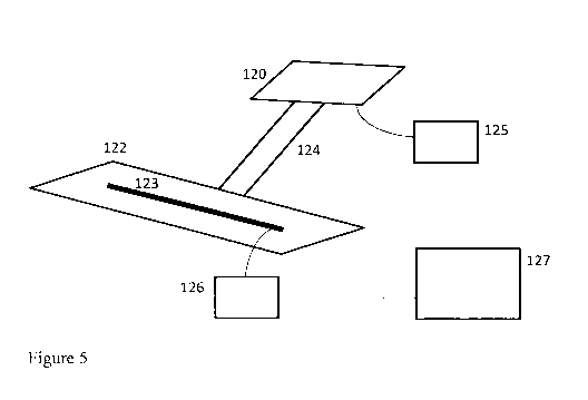
Figure 5 illustrates a gyroscopic/inertial instrument 123 mounted on an
instrument
platform 122, an external navigation system 120 and a rigid reference
structure
124 connecting the external navigation system and the instrument platform,
5 according to an embodiment of the invention;
Figure 6 shows a gyroscopic/inertial instrument 123 mounted on an instrument
platform 122 and three satellite antennas C1, C2 and C3 mounted on an antennae
platform 121 which is rigidly attached to reference structure 124, according
to an
embodiment of the invention;
10 Figure 7 shows a principle for determining the azimuth angle of the
satellite
antenna baseline according to an embodiment of the invention; and
Figure 8 shows the azimuth orientation of the external navigation system 201
from
Figure 5, and of the azimuth orientation of the gyroscopic/inertial instrument
202,
as seen from above (projected onto the horizontal plane) according to an
embodiment of the invention;
Figure 9 shows the azimuth orientation of the satellite antenna and of the
gyroscopic/inertial instrument 123, as seen from above (projected onto the
horizontal plane) according to an embodiment of the invention;
Figure 10 shows the flowchart for processing of the readings from the external
navigation system and from the gyro instrument according to an embodiment of
the invention; and
Figure 11 shows the attainable improvement in azimuth accuracy of a continuous
survey as a function of geographical latitude according to the invention.
DETAILED DESCRIPTION
The present invention will be described with reference to the drawings. The
same
reference numerals are used for the same or similar features in all the
drawings
and throughout the description.
The technical solution comprises:
= A gyroscopic/inertial instrument rigidly connected to an external navigation
system, whose orientation and change in orientation as a function of time
during calibration and initialization of the gyroscopic instrument is
registered
by the satellite receiver.
CA 02779172 2012-04-27
WO 2011/053161 PCT/N02010/000394
11
= During calibration and initialization, the gyro-instrument's orientation and
movements are registered by the gyro-instrument's normal registration
system.
= The two registrations above are synchronized in order to improve the
calibration and initialization accuracy of the gyro/inertial-instrument.
Embodiments of the invention are shown in Figures 5 and 6.
Figure 5 shows the physical components involved in a system for azimuth
initialization and calibration according to an embodiment of the invention. A
gyroscopic/inertial instrument 123 is mounted on an instrument platform 122.
In
Figure 5 the instrument platform 123 is arranged in a horizontal position.
However,
in an alternative embodiment the instrument platform 122 and the instrument
123
may be arranged in a vertical position. An external navigation system 120 is
connected to a rigid reference structure 124. The instrument platform is also
rigidly
connected to the rigid structure 124. The rigid structure 124 thus
interconnects the
external navigation system and the instrument platform providing a
mechanically
rigid connection between the gyro or inertial instrument 123 on the platform
and
the external navigation system. Both the external navigation system and the
gyro/inertial instrument will thus move together. The structure 120-124-122
has
sufficient rigidity such that the possible movements of the external
navigation
system equal the movement of the instrument 123, within a specified tolerance.
The external navigation system may be an inertial navigation system with high
accuracy, e.g. as used in the space industry.
A receiver 125 of the external navigation system registers the change of
orientation as a function of time during azimuth initialization of said
gyroscopic
and/or inertial instrument and provides an azimuth measurement as a function
of
time. This azimuth measurement is provided to a processor/computer 127. A
control and logging unit 126 for the gyro /inertial instrument 123 receives
signals
from the gyro/inertial instrument during azimuth initialization of orientation
and
movement as a function of time of said gyroscopic and/or inertial instrument
by the
inertial registration system of said gyroscopic and/or inertial instrument.
The
processor/computer 127 synchronizes the azimuth measurement as a function of
time provided by the external navigation system with the orientation and
CA 02779172 2012-04-27
WO 2011/053161 PCT/N02010/000394
12
movement provided by the inertial registration system of the gyroscopic and/or
inertial instrument.
On an oil rig, the gyro or inertial instrument may be arranged on the platform
deck
and the external navigation system on e.g. the helicopter deck, and the oil
rig itself
will thus form the rigid structure interconnecting the gyro/inertial
instrument to be
initialized with the external navigation system. The rigid structure may also
be
smaller, and embodiments may include a rigid structure to be placed on the
platform deck, to which the external navigation system is fixedly attached.
In an alternative embodiment, the external navigation system may be a
radio/satellite navigation system including antennas. At least two antennas
may be
arranged for receiving signals from the radio navigation system, wherein the
antennas are rigidly connected to the fixed reference structure. A receiver
performs synchronous measurements of a carrier phase of at least one signal
received by said at least two antennas providing the azimuth as a function of
time
of the at least two antennas. When using two antennas a further inertial
system for
providing a dip angle, enabling a fixation of a 3D coordinate system in time
for the
at least two antennas may be provided.
A further embodiment is illustrated in Figure 6. The three satellite antennas
C1, C2
and C3 are mounted on an antenna platform 121. The antenna platform is rigidly
connected to a rigid structure 124. The rigid structured may in an embodiment
be
a solid bracket. The use of at least three antennas enables a fixation of an
orientation of a 3D coordinate system in time for the at least three antennas.
A
multi-channel receiver 125 performs simultaneous measurements of a carrier
phase of several satellite signals at all antennas. This configuration allows
for
continuous registration of the 3-D orientation of the antenna system. The
gyroscopic/inertial instrument 123 is mounted on an instrument platform 122.
The
rigid structure 124 connects 121 and 122 mechanically. The actual design of
the
structure comprising 121, 122, and 124 will depend on rig floor conditions
like
closeness to the wellhead and where free sight to satellites can be obtained.
The
structure 121-122-124 may thus be shaped individually for each drilling site.
However, for some practical reasons a standardized shape may be preferred in
CA 02779172 2012-04-27
WO 2011/053161 PCT/N02010/000394
13
certain circumstances. The structure 121-122-124 has sufficient rigidity such
that
the possible movements of the antennas C equal the movement of the instrument
123, within a specified tolerance. As explained above, e.g. an oil rig may
form the
actual rigid structure itself. 126 is the control and logging unit for the
gyro
instrument. This unit, and the satellite receiver 125, are both connected to a
dedicated computer 127, which processes and synchronizes the registered motion
of both antenna system and gyro instrument. This implies that the registered
orientation of the satellite antenna is fed to the gyro system during azimuth
initialization and calibration.
For the embodiments above, it is also possible to provide a different mounting
(e.g. vertical) of the instrument platform 122 and the gyro 123 during azimuth
initialization and calibration.
The gyroscopic and/or inertial instrument may further include a gyroscopic
sensor
and/or an inertial sensor. The gyroscopic sensor and/or an inertial sensor may
be
a rotating mass gyro, fibre optical gyro, ring laser gyro, vibrating structure
gyro /
Coriolis vibratory gyro; strap-down or gimballed configurations.
The following factors should be considered in the design of the framework:
= Mechanical vibrations corresponding to gyro tool resonances should be
avoided.
= Overall stability.
= Requirements to relative orientation (azimuth) of gyro tool and antenna
= Mechanical shocks and rough handling of the gyro tool should be avoided
after initialization
The external navigation system may be a standalone inertial navigation system.
The external navigation system may however also be a radio navigation system
or
a satellite navigation system. Examples of satellite positioning systems that
may
be used for initialization and calibration are GPS, GLONASS, or Galileo.
When using a satellite system as an external navigation system, a factor in
the
design of the framework may be visibility of sufficient number of satellites
from the
antenna.
CA 02779172 2012-04-27
WO 2011/053161 PCT/N02010/000394
14
The external navigation system should typically be able to provide:
determination
of azimuth angle for alignment of the gyroscopic/inertial system; a
measurement,
update frequency = 10Hz; accuracy = 0.1 ; time-tagging = 0.05s and "Real-
time"
transfer of data.
If using a GPS receiver with many channels, the phase of the carrier wave of
incoming satellite signals from many satellite signals to several antennas
(typically
three) are measured simultaneously. This enables initialization of azimuth
angle
(orientation) of the gyro/inertial instrument.
Typical gyro reading rates are 100 Hz. Typical satellite reading rates are 1-
100 Hz,
depending on the receiver's complexity. The upper range of these data rates is
considered sufficient to track expected rig movements.
The accuracy of the satellite antenna's orientation, and thus of the gyro
instrument's orientation, depends on the physical size of the antenna,
represented
by the antenna's baseline.
The azimuth accuracy is an inverse function of the length of the antenna
baseline,
L. M k/L , where k is a constant.
The initialization accuracy for the azimuth angle is approximately 0.15-0.2
at
equator for the most accurate of the today's continuous gyro services. A
reasonable requirement to the satellite receiver's accuracy is therefore 0.1
. This
corresponds to an antenna baseline of approximately 2.5 m.
Figure 7 shows a principle for determining the azimuth angle Azb, of the
satellite
antenna baseline. By definition, the azimuth angle Azb, lies in the horizontal
plane,
and the figure shows the horizontal projection of the arrangement.
The satellite beam S, where one wavefront wf is indicated, is received by two
antennas C1 and C2. These antennas are separated by a baseline of length Lb,,
which has an arbitrary azimuth orientation Azb, with respect to a reference
direction
N (North). dL is a horizontal component of a distance difference between the
satellite and C, and C2, respectively. This distance is derived from a phase
CA 02779172 2012-04-27
WO 2011/053161 PCT/N02010/000394
difference of the satellite signal at C, and C2. The angle a between the
horizontal
projection of the satellite beam and the antenna baseline is thus given by
cos(a)
dULb,, or a = arccos(dULb,). Thus, the unknown azimuth angle of the baseline
becomes Azb, = Azsat + a = Azsat + arccos(dULb,).
5 For the shown arrangement in Figure 7 with only one satellite and only two
antennas, the measurement of phase difference between C, and C2 can only
determine dL as a fraction of a wavelength, and an unknown number of whole
wavelengths remain unknown. This gives rise to an ambiguity in dL and hence in
a. Furthermore, the sign of a can not be uniquely determined. Both these
10 ambiguities are resolved by utilizing simultaneously the signals from
several
satellites, and by using more antennas. The use of more satellites and more
antennas will also improve the accuracy and the reliability of the system.
The ambiguity is eliminated by using one additional receiver C3, positioned
such
that no baselines between any pair of receivers are parallel. The use of this
15 additional receiver also implies additional estimates for the azimuth Azbl,
and this
can be used to improve the overall accuracy of this parameter.
Figure 8 shows the azimuth orientation of the external navigation system
satellite
antenna, and of the gyroscopic/inertial instrument 123, as seen from above
(projected onto the horizontal plane). 201 is the azimuth reference axis for
external
navigation system and 202 is the azimuth reference axis for inertial
navigation
system. The rigid structure shown as 120-124-122 in Figure 5 is here
represented
by a single structure J. The azimuth difference angle tp is solely related to
the rigid
structure J, and the stiffness of this structure determines the accuracy of
during
the calibration and initialization processes.
Figure 9 shows the azimuth orientation of the satellite navigation system
satellite
antenna, and of the gyroscopic/inertial instrument 123, as seen from above
(projected onto the horizontal plane). The rigid structure shown as 121-124-
122 in
Figure 6 is here represented by a single structure J. The azimuth difference
angle
q is solely related to the rigid structure J, and the stiffness of this
structure
determines the accuracy of tp during the calibration and initialization
processes.
CA 02779172 2012-04-27
WO 2011/053161 PCT/N02010/000394
16
Figure 10 shows a flow chart for processing of the satellite receiver and gyro
instrument readings. After time synchronization, the azimuth derived from the
satellite signal replaces the gyro azimuth. This procedure is used for both
azimuth
initialization of a continuous gyro survey, and for on-site calibration for
any gyro
service.
The system is applicable at any geographical location, including far north and
far
south latitudes. Figure 11 shows the attainable improvement in azimuth
accuracy
of a continuous survey, as a function of geographical latitude. The points
labeled
Gyrocompassing are the same as those shown in Figure 2. By using the NEW
initialization method offered by this invention, the azimuth uncertainty will
be
independent of latitude, and equal to the value at the equator.
In the description above, the invention exemplify the external navigation
system by
a satellite system in some of the embodiments, but other external navigation
systems can also be applied.
The present invention for azimuth initialization may also be used for
calibration of
the gyroscopic or inertial instrument.
Applications and benefits
Continuous gyroscopic survey
Figure 4 shows the standard procedure of a continuous gyroscopic survey. The
major potential benefits of the external navigation solution are:
= Calibration and initialization can be done in a single operation; this will
facilitate the calibration/initialization procedure.
= The accuracy of azimuth initialization will be independent of latitude
(equal
to the accuracy at equator); this will improve the total survey accuracy. This
holds for any type of gyroscopic and inertial sensor and instrument.
= The instrument does not need to be clamped to the wellbore wall or casing
for initialization; this will facilitate the initialization procedure.
= On-site calibration can be done also on floating installations; this will
improve the total survey accuracy.
CA 02779172 2012-04-27
WO 2011/053161 PCT/N02010/000394
17
= Reduction of the total survey time; this will reduce the operator's cost.
Notice that with the external navigation solution, initialization will no
longer be
carried out in the borehole, but on the platform deck.
Stationary gyroscopic survey
Figure 3 shows the standard procedure of a stationary gyroscopic survey. The
major potential benefit of the external navigation solution is:
= On-site calibration can be done also on floating installations; this will
improve the total survey accuracy.
Having described preferred embodiments of the invention it will be apparent to
those skilled in the art that other embodiments incorporating the concepts may
be
used. These and other examples of the invention illustrated above are intended
by
way of example only and the actual scope of the invention is to be determined
from the following claims.