Note: Descriptions are shown in the official language in which they were submitted.
CA 02780350 2012-05-09
WO 2011/058212 PCT/F12009/050904
1
RUNWAY MEASUREMENT SYSTEM AND METHOD
FIELD OF THE INVENTION
The present invention relates to measuring systems, and more par-
ticularly to a measurement system for measuring dimensions of a runway.
BACKGROUND OF THE INVENTION
A runway refers here to a surface on which an object may travel. In
the vertical direction, the runway thus comprises a plane that is
substantially
perpendicular to the ambient gravitational force. Typically the runway also
comprises some mechanism that eliminates possible lateral forces to allow
progress of the object along the runway.
A well known example of a runway is a rail system that may corn-
prise one, two or more rails, mounted on the ground such that their top
surface
is substantially perpendicular to the ambient gravitational force. Rail
systems
are surveyed periodically to ensure the dimensions of the rails are within es-
tablished geometrical values (standards). Data generated during the survey is
then utilized to correct the positioning of the rails if there is any
deviation.
Traditionally runway surveys have been performed with manual ar-
rangements that apply theodolites or lasers. Recent years have brought in use
a tachymeter that can be fixed to one position while a target moves longitudi-
nally along a rail to predefined measuring positions. By measuring the coordi-
nates and distance of the target, the values needed to compute dimensional
characteristics of the rail defined in the runway standards (for example span,
rail to rail elevation, elevation and straightness) can be directly
determined.
Recently, a number of automated measuring systems have been in-
troduced. Document US 2005/0111012 discloses a laser survey device, which
uses a remotely operated laser to perform a runway survey The laser survey
device includes a stationary component, that includes a self-leveling laser,
and
a mobile component, that includes a screen and an image capture device. In
operation, the stationary self leveling laser emits a beam of laser light
towards
the screen of the mobile component as the mobile component travels along the
length of a crane rail. As the mobile screen travels along the length of the
crane rail, the location of impact of the laser light on the mobile screen
changes depending on movement of the mobile screen within a plane perpen-
dicular to the steady beam of laser light emitted by the stationary, self
leveling
laser. The image capture device captures and transmits to a remote computer
CA 02780350 2015-07-28
2
information related to location of impact of the laser light on the mobile
screen.
The remote computer uses the received information to assess alignment of the
crane rail.
U.S. Patent No 6,415,208, describes a laser-based survey device that is
very similar, in both design and operation, but is configured to collect
alignment
data for top-rail crane rail configuration.
Document WO 2007/087317 describes a method and apparatus for
conducting an overhead crane runway system survey by using a survey apparatus
that is alternately pushed or pulled by an overhead crane.
Document EP20 7574 discloses a arrangement for measuring a rail that
comprises a fixed tachymeter and a mobile reflecting surface. The measurement
comprises determining the position of the mobile element and transmitting the
measurement results over the air interface to a computer for further
processing.
The problem with any of these automated solutions is deficient accuracy of
the results. Rails may have local structures that disrupt the otherwise
substantially linear dimensions of the rail. In time and use the rails also
wear and
the surface on which the moving target travels begins to comprise
deformations.
These structures caused by deformations and/or local structures are in the fol-
lowing called jointly as defects, and they may cause the measuring elements to
diverge from their initial, planned spatial configuration. This spatial
configuration
is, however, a basis for computing equations and algorithms used in
determining
the surveyed result values. When the spatial configuration between the
separate
elements changes, the results become distorted. The reliability of the
measured
values is thus uncontrollably dependent on the state of the measured track,
which
is not acceptable.
BRIEF DESCRIPTION OF THE INVENTION
An object of the present invention is thus to provide a method and an
apparatus for implementing the method to improve the accuracy of runway
measurements.
Embodiments of the invention apply a fixed unit and a mobile unit
carrying a reflector from which a measurement signal from the fixed unit is di-
rected. Defects in the track mean that a plane carrying the target and a plane
perpendicular to the ambient gravitational force are not parallel but deviate
from
CA 02780350 2016-06-21
- 3 -
each other. In the invention, these deviations are measured and the effect
from
the determined deviations is then eliminated. This facilitates more accurate
results, and detaches the accuracy of the results from the local structures or
state
of the measured track. This and the possible further advantages are discussed
in
more detail with the detailed description of embodiments illustrating the
invention.
Accordingly, in one aspect there is provided a measurement system for
measuring a surface defined by two or more rails, the measurement system
comprising: a fixed measurement unit; a mobile measurement unit; and a
computing unit, the mobile measurement unit comprising: a base and a
reflector;
an elevation element fixed to the base and the reflector, and attaching the
reflector to a fixed position in respect of the base, wherein the base has a
reference plane in a fixed position with respect to the base such that a tilt
of the
base in respect of a computational horizontal plane can be determined based on
a
tilt of the reference plane; mobility means, configured to move the base along
the
surface such that a spatial orientation of the reference plane of the base
corresponds with a spatial orientation of a currently underlying part of the
surface,
wherein the mobility means comprises a rail tracker for moving the mobile
measurement unit substantially along a track formed by a mid-line of a top
surface
of one of the rails; tilt measuring means for determining a tilt of the mobile
measurement unit as a deviation between the spatial orientation of the base
and a
plane perpendicular to the ambient gravitational force; and transmission means
for
transmitting the determined tilt to the computing unit, the fixed measurement
unit
comprising: measurement means configured to determine a position of the
reflector in respect of the fixed measurement unit; and interface means for
transmitting the determined position of the reflector to the computing unit,
and the
computing unit comprising: reception means for receiving the determined tilt
of the
mobile measurement unit and for receiving the determined position of the
reflector
from the fixed measurement unit; and computing means for computing a tilt-
corrected result representing dimensions of the measured surface, on the basis
of
the determined position of the reflector and the determined tilt of the mobile
measurement unit.
CA 02780350 2015-07-28
3a
According to another aspect there is provided an operating method for a
measurement system for measuring a surface defined by two or more rails, the
measurement system comprising a fixed measurement unit, a mobile
measurement unit and a computing unit, the method comprising: at the fixed
measurement unit: generating a rectilinearly progressive signal, detecting a
reflection of the rectilinearly progressive signal from a reflector mounted on
the
mobile measurement unit, and determining a position of the reflector based on
the
generated rectilinearly progressive signal and the reflection; and
transmitting the
determined position of the reflector to the computing unit; at the mobile
measurement unit, which has a base and the reflector, the base having a
reference plane in a fixed position with respect to the base such that a tilt
of the
base in respect of a computational horizontal plane can be determined based on
a
tilt of the reference plane: attaching the reflector to a fixed position in
respect of
the base; moving the base along a surface such that a spatial orientation of
the
reference plane of the base substantially corresponds with a spatial
orientation of
a currently underlying part of the surface; moving the mobile measurement unit
substantially along a track formed by a mid-line of a top surface of one of
the rails;
determining a tilt of the mobile measurement unit as a deviation between the
spatial orientation of the base and a plane perpendicular to the ambient
gravitational force; and transmitting the determined tilt to the computing
unit; and
at the computing unit: receiving the determined tilt from the mobile
measurement
unit, and receiving the determined position of the reflector from the fixed
measurement unit; and computing a tilt-corrected result representing
dimensions
of the measured surface, on the basis of the determined position of the
reflector
and the determined tilt of the mobile measurement unit.
CA 02780350 2015-07-28
3b
BRIEF DESCRIPTION OF THE DRAWINGS
In the following the invention will be described in greater detail by means of
preferred embodiments with reference to the attached [accompanying] drawings,
in which
Figure 1 shows an arrangement that represents an interconnection of
entities for creating an embodied measuring system;
Figure 2 provides a side view of a mobile unit in a contoured surface;
Figure 3 illustrates a top view of a typical measurement configuration
between fixed and mobile unit elements of the measurement system;
Figure 4 illustrates in a side view two spatial orientations of a reflector of
the mobile unit;
Figure 5 illustrates an embodiment of the measurement system;
Figures 6A and 6B illustrate another embodiment of the measurement
system;
Figure 7 illustrates an embodiment of a method according to the invention
Figure 8 illustrates one measurement arrangement implemented by means
of the invented measurement system.
DETAILED DESCRIPTION OF SOME EMBODIMENTS
The following embodiments are exemplary. Although the specification may
refer to "an", "one", or "some" embodiment(s) in several locations, this does
not
necessarily mean that each such reference is to the same embodiments), or that
the feature only applies to a single embodiment. Single features of different
embodiments may also be combined to provide other embodiments.
CA 02780350 2012-05-09
WO 2011/058212 PCT/F12009/050904
4
In the following, different embodiments will be described using an
example of system architecture without, however, restricting the invention to
the disclosed terms and structures.
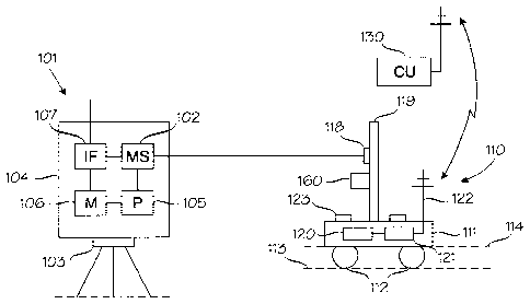
Figure 1 shows an arrangement that represents an interconnection
of entities for creating an embodied measuring system 100. Figure 1 is simpli-
fied system architecture chart that shows only elements and functional
entities
necessary to describe the implementation of the invention in the present em-
bodiment. It is apparent to a person skilled in the art that measuring systems
may also comprise other functions and structures not explicitly shown in
Figure
1. The illustrated entities represent logical units and connections that may
have
various physical implementations, generally known to a person skilled in the
art. In general, it should be noted that some of the functions, structures,
ele-
ments and protocols used for creating a context for the embodiments are, as
such, irrelevant to the actual invention. Words and expressions in the
following
descriptions are intended to illustrate, not to restrict, the invention or the
em-
bodiment.
The measuring system 100 comprises a fixed measurement unit
101. Fixed in this context means that the unit remains fixed during a measure-
ment. Between measurements the fixed unit 101 may be moved to another
location and fixed there for another measurement sequence.
The fixed measurement unit 101 comprises a measurement signal
unit 102 that is configured to generate a rectilinearly progressive signal to-
wards a reflective target, detect the reflected signal when it returns, and on
the
basis of the timing and/or position information of the outgoing and incoming
signals determine values representing the position of the target. The
rectiline-
arly progressive signal may be provided in the form of, for example, a laser
or
infrared light signal. However, other wavelengths or other types of signals
may
be applied within the scope of protection.
The fixed measurement unit 101 comprises also a fixing mechanism
103 that allows the fixed measurement unit 101 to be detachably secured to a
defined position. In its simplest form the fixing mechanism 103 may apply grav-
ity. For example, some part of a chassis 104 enclosing the measurement sig-
nal unit 102 may have a bottom surface that due to the weight of the fixed
measurement unit 101 presses against an underlying surface such that it re-
mains immobile throughout the measurement session. Typically the fixing
mechanism 103, however, comprises also some kind of adjustment mecha-
CA 02780350 2012-05-09
WO 2011/058212 PCT/F12009/050904
nism, for example a tripod, which also allows positioning of the signal source
to
a desired height and location. Depending on the application, fixed measure-
ment unit 101, for example its adjustment mechanism can be equipped with a
clamping arrangement that secures the fixed measurement unit 101 to a de-
5 fined point in respect of the measured surface. Other known fixing
methods
may be applied without deviating from the scope of protection.
The fixed measurement unit 101 comprises also a processor unit
105. The processor unit 105 is an element that essentially comprises one or
more arithmetic logic units, a number of special registers and control
circuits.
Connected to the processor unit 105 is a memory unit 106, data medium
where computer-readable data or programs. The memory unit 106 may com-
prise volatile or non-volatile memory, for example EEPROM, ROM, PROM,
RAM, DRAM, SRAM, firmware, programmable logic, etc.
The fixed measurement unit 101 also comprises an interface unit
107 with at least one input unit for inputting data to the internal processes
of
the fixed measurement unit 101and at least one output unit for outputting data
from the internal processes of the fixed measurement unit 101. If a line inter-
face is applied, the interface unit typically comprises plug-in units acting
as a
gateway for information delivered to its external connection points and/or for
information fed to the lines 107 connected to its external connection points.
If a
radio interface is applied, the interface unit typically comprises a radio
trans-
ceiver unit, which includes a transmitter and a receiver, and is also
electrically
connected to a processing unit 105. Depending on the application, the inter-
face unit may also support more than one type of interfaces. The interface
unit
107 may also comprise a user interface with a keypad, a touch screen, a mi-
crophone, or equals for inputting data and a screen, a touch screen, a loud-
speaker, or equals for outputting data.
The processor unit 105, the memory unit 106, and the interface unit
107 are electrically interconnected to perform systematic execution of opera-
tions on the received and/or stored data according to the predefined, essen-
tially programmed processes of the fixed measurement unit 101. These opera-
tions comprise compiling and forwarding values that represent the determined
position of the target to a defined external or integrated unit for computing.
As
well known to a person skilled in the art, the values may be transmitted as
raw
measurement data or the fixed unit may be configured to pre-process the val-
ues into coordinate values of a defined type and/or complement the values
CA 02780350 2015-07-28
6
with defined metadata. In general these operations comprise the part of the
fixed measurement unit in the measurement processes, described in more detail
later on in this description.
In an example, a fixed measurement unit 101 may be implemented
by means of a tachymeter. The tachymeter is a known device, which allows
making goniometric measurements simultaneously with measurement of
distances and on the base of received data to make engineering calculations,
keeping all existing information. The opportunity of transfer of the data
picking
during measurements through the special interface in a computer with the
subsequent processing have made tachymeter the one of the most popular
measurement devices in various technical fields. However, other measurement
solutions applying reflection of a rectilinearly progressing signal from the
target
may be applied without deviating from the scope of protection.
The measuring system 100 comprises also a mobile unit 110. The
mobile unit 110 comprises a planar base 111 and mobility means 112. The
mobility means 112 are attached to the planar base 111 and allow the base to
move along a surface 113 such that the spatial orientation of the base 114
substantially corresponds with the spatial orientation of the currently
contacted
part of the surface 113.
The concept of spatial orientation is illustrated in more detail in Figure
2. The base 111 has a substantially rigid form and any changes or movements
in its interface with the mobility means 112 are carried to the whole body of
the
base. The characteristic that the base 111 is planar means that the interface
with the mobility means 112 is not a single support point, but comprises two
or
more contact points, or a contact surface through which the resultant forces
from
the contact between the surface 113 and the mobility means 112 are conveyed
to the body of the base. Accordingly, forces by the impact of the mobility
means
with the contact surface have an effect to the body of the base 111 via more
than
one contact point. The spatial orientation of the base 111 is thus a result of
movement by all the contact points, or the whole contact surface to the
substantially rigid body of the base. For
illustrating and measuring the
spatial orientation of the base 111, a plane 114 in fixed position in respect
of the
body, preferably crossing the body of the base 111, is considered to
represent the spatial orientation of the base. When the mobile unit 110
moves on a surface, spatial orientation of this plane 114 represents the
change of orientation conveyed to any elements 119, 122 attached to the
CA 02780350 2012-05-09
WO 2011/058212 PCT/F12009/050904
7
mobile unit 110.
In Figure 1 the mobile unit 110 is on a horizontal surface. Figure 2
provides a side view of the mobile unit 110 in a contoured surface. In this ex-
ample, the mobility means 112 comprise wheels attached to the base 111.
When the mobile unit 110 runs, the wheels contact the underlying surface, the
spatial orientation 113 of the surface in respect to the horizontal level in
this
perspective is now a. The wheels mediate the spatial orientation, so the
spatial
orientation of the base 114 is also a. This is the case in an example where
the
wheels are equal and there is thus no initial deviation between the contact
plane and the base 111. In case some initial deviation exists, the the spatial
orientation of the base 114 is the sum of this initial deviation and a. In any
case, whether initial deviation exists or not, the deviations of the
underlying
surface 113 from the horizontal level 115 are conveyed directly to the spatial
orientation of the base 114. Clearly, any elements 119, 122 attached to the
16 base 111 experience a corresponding deviation or tilt a.
The mobile unit comprises also a reflector 118, and an elevation
element 119 fixed to the base 111 and the reflector 118. The reflector 118 is
configured to reflect a signal transmitted from the fixed unit 101. Depending
on
the type of the signal, the reflection may be caused in many ways, known to a
person skilled in the art. In the exemplary case of tachymeter the signal is a
light wave and the reflector returns the signal via total reflection, caused
by
means of a prism. The reflector 118 is attached to the elevation element 119,
which is further attached to the base 111 of the mobile unit 110. In Figure 1
the
elevation element 119 is attached perpendicularly in respect to the plane 114
illustrating the spatial orientation of the base 111. However, any mutual
orien-
tation (i.e. initial deviation) may be applied between the base 111 and the
ele-
vation element 119, as long as the elevation element 119 attaches the
reflector
118 to a fixed position in respect of the base 111.
The mobile unit is advantageously self-propelled and thus capable
of moving without external driving arrangements. This may be implemented by
any integrated driving mechanisms 120, as such generally known to a person
skilled in the art. The mobile unit may also be self-navigating, i.e. move
accord-
ing to a predefined internal moving scheme. However, advantageously the
mobile unit comprises a control element 121 that is connected to the driving
mechanism and comprises an interface for an external connection. The control
element structure may comprise a processor unit, a memory unit, and an inter-
CA 02780350 2012-05-09
WO 2011/058212
PCT/F12009/050904
8
face unit, which are electrically interconnected to perform systematic
execution
of operations on the received and/or stored data, as described in the case of
the fixed unit. The received data may comprise driving instructions,
transmitted
from an authorized external source. Since the mobile unit is moving, the exter-
nal connection is preferably implemented over a radio interface. For radio
communication, the mobile unit 110 advantageously comprises a radio trans-
ceiver 122 that includes a transmitter and a receiver.
The measuring system 100 comprises also a computing unit 130.
The computing unit 130 may be any node or a host which is able to provide an
interface or interfaces through which the fixed unit and/or the mobile unit
may
exchange information with it, and process the received an possibly stored in-
formation, as will be discussed below. The apparatus may also be a user ter-
minal which is a piece of equipment or a device that associates, or is
arranged
to associate, the user terminal and its user with a subscription and allows a
user to interact with a communications system. The user terminal presents in-
formation to the user and allows the user to input information. In other
words,
the user terminal may be any terminal capable of receiving information from
and/or transmitting information to the network, connectable to the network
wirelessly or via a fixed connection. Examples of the user terminal include a
personal computer, a console, a laptop (a notebook), a personal digital assis-
tant, a mobile station (mobile phone), and a line telephone.
In general, various embodiments of a computing unit apparatus may
be implemented in hardware or special purpose circuits, software, logic or any
combination thereof. Some aspects may be implemented in hardware, while
some other aspects may be implemented in firmware or software, which may
be executed by a controller, microprocessor or other computing device. Soft-
ware routines, which are also called as program products, are articles of manu-
facture and can be stored in any apparatus-readable data storage medium and
they include program instructions to perform particular tasks. Thus the exem-
plary embodiments of this invention also provide a computer program product,
readable by a computer and encoding instructions for executing a process for
surface measurement in a measuring system of Figure 1.
In an example, the computing unit may be implemented with a per-
sonal computer that provides a radio connection to the fixed unit 101 and/or
the mobile unit 110. Local or cellular radio technologies may be applied in
the
radio connection.
CA 02780350 2012-05-09
WO 2011/058212
PCT/F12009/050904
9
Figure 3 shows a top view of a typical measurement configuration
between the fixed unit 101 and mobile unit 110 elements of the measurement
system 100. In one measurement, the fixed unit 101 measures and records at
least a horizontal coordinate x, a vertical coordinate y (not shown) and dis-
tance D of a defined point (in this embodiment the reflector 118) of the
mobile
unit 110. A defined algorithm is applied to compute any further result values
from these measured values.
Figure 4 illustrates in a side view two spatial orientations 118' and
118" of the reflector 118 of the mobile unit. When the mobile unit moves an a
substantially horizontal plane, the spatial orientation of the base 114
parallel to
the horizontal direction x is zero and the coordinates of the reflector 118'
that
the elevation element 119 raises to the height L from the base 111 are
(x',y').
However, in case the surface is defected and therefore not horizontal, the
base
111 tilts such that the spatial orientation of the base 114 is a. Due to this
devia-
tion the measured position coordinates (x",y") deviate correspondingly by Ax
and Ay from the original values (x1,y'). Generally the applied algorithm is
based
on an assumption that the base 111 on which the elevation element 119
stands is parallel to the selected horizontal direction x. This means that the
deviations Ax and Ay, caused by the measured surface not being parallel with
a plane perpendicular to the ambient gravitational force, cause an error to
the
measurement results computed with the algorithm. In practise, these errors
may be detrimental to the reliability of the results, especially the errors Ax
in
the horizontal direction.
Thus, in order to improve the accuracy of the results, the measuring
system 100 of the present embodiment comprises also tilt measuring means
123 (Figures 1 and 3) for determining a deviation between the base and the
plane perpendicular to the ambient gravitational force. Tilt measurement
means may be implemented in various ways. In one implementation, the de-
viation is presented and measured in form of a tilt angle a, and the mobile
unit
110 may comprise an inclinometer or clinometer, which is an instrument for
measuring angles of slope (or tilt), elevation or inclination of an object
with re-
spect to gravity. Examples of inclinometers comprise a tilt meter, tilt
indicator,
slope alert, slope gauge, gradient meter, gradiometer, level gauge, level
meter,
declinometer, and pitch & roll indicator. In another implementation the mobile
unit 110 may be configured to comprise a number of measuring points in dif-
ferent, defined parts of the base 111. By measuring the positions of these
CA 02780350 2012-05-09
WO 2011/058212 PCT/F12009/050904
measuring points and using the knowledge of their mutual spacing in the base
111, the tilt a of the base 111 in respect of a computational horizontal plane
can be easily computed.
The measuring system 100 of the present embodiment comprises
5 further tilt elimination means for eliminating the effect of the
determined devia-
tion. Depending on the application, elimination may be implemented during or
after the measurement procedure.
Figure 5 illustrates an embodiment where the tilt elimination is im-
plemented during the measurement procedure and the tilt elimination means
10 comprise a balancing mechanism integrated to the mobile unit 110. In
Figure
5, the mobility means 112 of the mobile unit 110 are made to provide a rail
tracker that allows the mobile unit to move substantially along a track formed
by the mid-line of the top surface of the rail. The rail tracker of the
embodiment
comprises a recess 140, the cross-section of which is dimensioned to encom-
pass the top surface of the rail and at least part of the side surfaces of the
rail.
The side walls of the recess 140 oppose the lateral forces and provides a side
tracker that ensures that the rail is retained within the recess while it
moves to
a forward direction. The rail tracker comprises also a wheel mechanism 141,
which is attached to the base 111 such that at least some wheels protrude
from the bottom of the recess to provide a rolling contact to the top surface
of
the rail.
At least one further wheel, a side wheel 142, may be included to
the wheel mechanism 141 to enhance the side tracker by rolling against refer-
ence a side of the rail. The reference side of the rail is advantageously the
side
that is best aligned with the track formed by the mid-line of the top surface
of
the rail. The wheel mechanism 141 is adjusted such that when the side wheel
is against the reference side of the rail, the reflector is substantially
vertically
aligned with the mid-line of the top surface of the rail. In some cases the
refer-
ence side of the rail may also be subjected to normal wear. In order to corn-
pensate the effect of such wear to the measurement, the side wheel 142 may
be made vertically adjustable. This allows the measurement operator to select
from the reference surface a track that is in a height which seems least af-
fected by the wear.
It is noted that this rail tracker construction is an example only. Sev-
eral rail tracking mechanisms, applying different tracking surfaces and
rolling
or sliding mechanisms can be applied without deviating from the scope of pro-
CA 02780350 2012-05-09
WO 2011/058212 PCT/F12009/050904
tection.
The tilt measuring means 123 and the control element 121 are in-
terconnected such that the measured values of the tilt measuring means are
input to the control element 121. The control element is also interconnected
with the driving mechanism 120 that drives the wheels in the wheel mechanism
141. In addition to the conventional rotational control that controls the rota-
tional movement of the wheels, the driving mechanism 120 of the present em-
bodiment comprises also a vertical control mechanism 124 by means of which
parallel wheels of the wheel mechanism 141 can be lifted or lowered inde-
pendent of each other. Accordingly, the mobile unit can be positioned to at
least temporally adjust the spatial orientation of the base 114 to eliminate
the
effect of the determined deviation. This may be implemented, for example, by
adjusting the spatial orientation of the base 114 to be substantially parallel
with
the plane perpendicular to the ambient gravitational force. In the present ex-
ample, the control element 121 stores a tilt value that defines the threshold
for
triggering operation of tilt elimination means. When a value received from the
tilt measuring means 123 exceeds this tilt value, the control element 121 in-
structs the driving mechanism 120 to lift one wheel and/or lower the other
wheel to compensate the effect of the tilted rail surface.
The measurement system 100 may be configured to take meas-
urements continuously or discretely. In discrete measurements the mobile unit
110 is stopped to the measurement point at least for the time the measurement
is taken. In continuous measurements the measurement may be taken while
the mobile unit 110 moves. Both measurement types result in a number of dis-
crete measurement values associated to a defined measurement time value,
but typically the continuous measurements generate a larger number of re-
sults. Depending on the measurement arrangement applied in the system, also
the spatial orientation of the base 114 may be adjusted discretely or continu-
ously.
Discrete adjustments may be made at defined points of time and/or
at defined locations of the measured path. For discrete measurements, the
mobile unit 110 may comprise a measurement timing unit 150 for detecting
times when a measurement signal falls to the reflector. Advantageously, the
tilt
is measured and the effect from the deviation is eliminated before the actual
measurement, i.e. before a time when a measurement signal falls to the reflec-
tor. In case time based adjustment is applied, the measurement timing unit 150
CA 02780350 2012-05-09
WO 2011/058212 PCT/F12009/050904
12
may be a clock unit that is synchronised with the processor 105 of the fixed
unit 101 and recognizes the measurement times when the discrete measure-
ment signals are transmitted from the fixed unit 101. The clock unit may be,
for
example, controlled by the control element 121 of the mobile unit 121 and pre-
programmed with a set of measurement times or intervals. In a defined time
just before the measurement time, the control element triggers tilt measuring
means 123, in response to which the tilt elimination means 124 may be trig-
gered, depending on the measured tilt value.
In case a location based adjustment is applied, the measurement
timing unit 150, or a control unit 121 controlling the operations of the meas-
urement timing unit 150, be configured to, for example, receive from the wheel
mechanism 141 an indication of a full rotation of the wheels and increment a
counter each time an indication is received. The timer value translates
directly
into traversed distances and can be used to synchronize the operations of the
fixed unit 101 and the mobile unit 110. For example, let the fixed unit be con-
figured with an external mechanism to trigger a measurement signal at defined
locations of the measured track. Again, just before such measurement is due,
the control element triggers tilt measuring means 123, in response to which
the
tilt elimination means 124 may be triggered, depending on the measured tilt
value.
In continuous measurements the adjustment is advantageously
done as fast and as often as possible such that the effect from in the
measured
surface is effectively eliminated. Advantageously, the tilt elimination means
124 adjust the spatial orientation of the base in all these cases to be
substan-
tially parallel with the plane perpendicular to the ambient gravitational
force. It
is noted that other mechanisms for timing and synchronizing the units during
the measurement may be applied without deviating from the scope of protec-
tion.
Figures 6A to 6B illustrate another embodiment, where the tilt elimi-
nation is implemented retroactively to the generated measurement results. As
illustrated in Figure 6A, a conventional computing unit 130 interfaces at
least
the fixed unit, and receives from it, continuously or in a batch run a
plurality of
measurement records n, associated to a measurement of a defined track. The
computing unit 130 comprises at least one algorithm Ak(r) that on the basis of
the measured values ri, computes a result Rk that represents dimensions of the
measured track. Depending on the system design, the computing unit may
CA 02780350 2012-05-09
WO 2011/058212 PCT/F12009/050904
13
comprise one or more algorithms Ak(r,), k=1,...,K.
As shown in Figure 6B, the computing unit of the present embodi-
ment is further configured to receive from the mobile unit 110, continuously
or
in a batch run, a plurality of measured deviation values t, representing a
meas-
ured deviation between the base 111 of the mobile unit 110 and a plane per-
pendicular to the ambient gravitational force around the mobile unit. Each of
the deviation values t, can be associated to a defined measurement record n,
of a defined track, either implicitly or explicitly. In implicit association,
the algo-
rithm pairs the measurement records and deviation values without explicit as-
sociation information attached to the measured values. For example, in syn-
chronously timed measurements the number of results in both input streams ri,
t, should match such that the computing unit 130 can pair the values according
to their input order. In explicit association, input records in either or both
of the
input streams r,, t, carry a further pairing or synchronization value (for
example,
measurement time) by means of which he computing unit 130 can pair the val-
ues. As well known to a person skilled in the art, also the deviation values
t,
may be transmitted as raw measurement data or the mobile unit may be con-
figured to pre-process the values into coordinate values of a defined type
and/or complement the values with further metadata.
The computing unit 130 of Figure 6B comprises at least one algo-
rithm Ak(rht,) that on the basis of the measured values ti, computes a tilt
cor-
rected result Rk* that represents dimensions of the measured track, but where
the effect of the deviations Ax and Ay caused by defects in the measured sur-
face are eliminated. Computing deviations Ax and Ay and restoring values
(x',y') when L and a are known is simple trigonometry, well known to a person
skilled in the art. It is evident that Rk* is much more accurate than Rk.
Depend-
ing on the system design, the computing unit may comprise one or more algo-
rithms Ak(rht,), k=1 ,...,K.
In a further embodiment, the mobile unit may be further equipped
with a camera unit 160 (Figure 2) that comprises a camera that generates im-
ages in at least one view at defined points along the track. Advantageously,
the camera unit 160 also comprises an image tracker that is configured to as-
sociate an image taken with the camera with tracking information that allows
association of the image to a position of the mobile unit 110 where the image
was taken. Accordingly, in this embodiment, in addition to the plurality of
measured deviation values t,, (Figure 6B) the mobile unit 110 also sends to
the
CA 02780350 2012-05-09
WO 2011/058212 PCT/F12009/050904
14
computing unit 130 a plurality of camera records I; that comprise at least an
image and tracking information for that image.
By means of the image tracker the defects can be further mapped to
a defined image and the type of the defect may be then verified visually for
efficient repair planning. For example, deviations caused by designed struc-
tures do not typically require further actions, so repair actions can be
focused
to other anomalies, like deformations caused by wear and tear.
On the other hand, the images may also be used to verify accura-
cies of results in some specific cases where the tilt measurement, as such may
not react to the defect in the rail. For example, if the rail comprises a
short cut,
it may be compensated by the horizontal extent of the body of the base, and
no tilt is detected or measured. However, parallel visual analysis allows
detect-
ing and locating also such points along the track.
Figure 7 illustrates an embodiment of a method according to the in-
vention. In Figure 7 the method is implemented in a computing unit 130 of the
measurement system 100 described in Figures 2-6, so description of Figure 7
may be complemented with any parts of descriptions of those Figures, and
vice versa. The procedure begins in a stage where the computing unit 130 is
switched on and operative. First the unit is configured (step 70) with at
least
one algorithm Ak(ri,ti). The algorithm inputs measured coordinate values of a
mobile unit 110 riõ and based on these coordinate values computes at least
one result that represents dimensions of the track the moving object moved
along. In addition the algorithm uses the measured deviation values ti, to
elimi-
nate the effect of the deviations Ax and Ay caused by defects in the measured
surface from the results and thereby provide a tilt corrected result Rk*.
Accordingly, during or after the measurement procedures in the
fixed unit 101 and the mobile unit 110s, the unit receives (step 71) measure-
ment records n, associated to a measurement of a defined track. In addition
the unit receives (step 72) measured values ti, for a deviation between the
base
of the mobile unit and a plane perpendicular to the ambient gravitational
force
around the mobile unit. The unit eliminates (step 73) the effect of the devia-
tions Ax and Ay caused by defects in the measured surface by computing de-
viations Ax and Ay and restoring values (x',y), as shown in Figure 4. Then the
unit outputs (step 74) the tilt corrected result RI: for, for example,
evaluating
the status of the measured track.
Due to measuring the deviations between the base supporting the
CA 02780350 2012-05-09
WO 2011/058212 PCT/F12009/050904
elevation element and a plane perpendicular to the ambient gravitational
force,
and eliminating the effect of the determined deviation, the output results Rk*
are significantly more accurate than available through conventional means. It
is
further noted that the measured tilt values may be used, as such, to indicate
5 the inclination of the rails. Also, as previously described, the measured
devia-
tion value stream 4 may be complemented with the stream of camera records I,
to facilitate efficient repair planning.
Figure 8 illustrates one important measurement arrangement im-
plemented by means of the invented measurement system. The measured
10 tracks comprise two parallel rails Ti, T2 that form a driveway for a
trolley mov-
ing heavy objects. Initially, the rails T1, T2 are mounted such that the top
sur-
faces of the rails are parallel to a plane perpendicular to the ambient
gravita-
tional force. At use, the surfaces of the rails wear. Industry standards aim
to
ensure security and operability of the driveways and therefore provide strict
15 requirements to the dimensions of the rails, individually and also to
their mutual
positioning. Due to the invented solution, the mobile unit 110 can move along
each of the rails T1, T2 separately, the fixed unit 101 can remain in one
fixed
position, and results for both individual dimensions and mutual positions of
the
rails can be quickly received. The effects of the tilting of the mobile unit
that
moves along the rails are eliminated so the accuracy of the results in not de-
pendent on the condition of the rails, so any wear possibly existing on the
rail
does not deteriorate the measurements or the evaluation of the situation.
The exemplary embodiments of this invention also provide a com-
puter program product, readable by a computer and encoding a computer pro-
gram of instructions for executing a computer process for controlling
functions
in the measuring system of Figure 2.
While various aspects of the invention may be illustrated and de-
scribed as block diagrams, message flow diagrams, flow charts and logic flow
diagrams, or using some other pictorial representation, it is well understood
that the illustrated units, blocks, apparatus, system elements, procedures and
methods may be implemented in, for example, hardware, software, firmware,
special purpose circuits or logic, a computing device or some combination
thereof. It will be obvious to a person skilled in the art that, as the
technology
advances, the inventive concept can be implemented in various ways. The in-
vention and its embodiments are not limited to the examples described above
but may vary within the scope of the claims.