Note: Descriptions are shown in the official language in which they were submitted.
CA 02784103 2012-06-12
WO 2011/073861 PCT/IB2010/055703
METHOD FOR MODELING A RESERVOIR BASIN
CROSS-REFERENCE TO RELATED APPLICATION
[0001] The present application claims priority from US Provisional Application
61/286,454, filed December 15, 2009, which is incorporated herein by
reference.
BACKGROUND OF THE INVENTION
[0002] Stratigraphic hydrocarbon basin models have been used to gain a better
understanding of characteristics of hydrocarbon basins. However, traditional
stratigraphic modeling has been limited by the resolution of regional-scale
measurements,
e.g. resolution of seismic data. Traditional modeling attempts to overcome
this limitation
by using supplemental core-scale data and log data, but current processes lack
sufficient
definition of the fine-scale variability of material properties along the
seismically defined
stratigraphic units. The consequence is a lower resolution model and
homogenization of
material properties across regions which, in reality, are substantially
heterogeneous. This
type of model may have value for initial exploration, but the model lacks
resolution for
impacting field development, e.g. drilling, completion strategy, and
production.
BRIEF SUMMARY OF THE INVENTION
[0003] In general, the present invention provides a methodology for improved
modeling of a geologic region, such as a hydrocarbon-bearing basin. The
methodology
comprises processing data to create a heterogeneous earth model based on a
variety of
data on material properties across the basin. The heterogeneous earth model is
employed
in combination with a stratigraphic model in a manner which creates a higher
resolution
geologic-stratigraphic model. The high resolution geologic-stratigraphic model
is useful
for improving the analysis of geologic regions, such as hydrocarbon bearing
basins, in a
manner which provides information for improved field development.
1
CA 02784103 2012-06-12
WO 2011/073861 PCT/IB2010/055703
BRIEF DESCRIPTION OF THE DRAWINGS
[0004] Certain embodiments of the invention will hereafter be described with
reference to the accompanying drawings, wherein like reference numerals denote
like
elements, and:
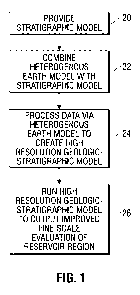
[0005] Figure 1 is a flowchart illustrating an example of a method for
modeling a
geologic region, such as a hydrocarbon bearing basin;
[0006] Figure 2 is a schematic illustration of a processing system which may
be
used to create and run a high resolution stratigraphic model;
[0007] Figure 3 is a flowchart illustrating a more detailed example of a
method
for modeling a geologic region;
[0008] Figure 4 is a schematic illustration of data collected for processing;
[0009] Figure 5 is a schematic illustration of data collected for assembly of
an
initial stratigraphic model based on log correlation;
[0010] Figure 6 is schematic illustration representing a log correlation
consistent
with rock class definitions and core geology;
[0011] Figure 7 is schematic illustration representing changes in thickness
within
the same unit or rock class;
[0012] Figure 8 is a schematic illustration providing a map of rock units or
classes based on heterogeneous rock analysis definitions and other data;
2
CA 02784103 2012-06-12
WO 2011/073861 PCT/IB2010/055703
[0013] Figure 9 is a schematic illustration of changes in thickness and the
development of major patterns in the properties of rock units or classes to
identify a
geologic trend of major events;
[0014] Figure 10 is a schematic illustration of patterns in unit or rock
classes
thickness between time intervals which indicate and map structural features;
[0015] Figure 11 is a schematic illustration of a living model for a given
geologic
region, such as a hydrocarbon bearing basin; and
[0016] Figure 12 is a schematic illustration of how the new high resolution
geologic model described herein can help identify the transformation of
depositional
units in a basin to various rock types including favorable gas shale units.
DETAILED DESCRIPTION OF THE INVENTION
[0017] In the following description numerous details are set forth to provide
an
understanding of the present invention. However, it will be understood by
those of
ordinary skill in the art that the present invention may be practiced without
these details
and that numerous variations or modifications from the described embodiments
may be
possible.
[0018] The present invention generally relates to a methodology of improved
modeling with respect to geologic features. For example, the method of
modeling may
employ a high resolution geologic-stratigraphic model which is readily
applicable to
hydrocarbon-bearing basins. The improved modeling technique facilitates not
only
exploration of hydrocarbon-bearing formations and/or other geologic features
but also
facilitates field development which may include improved drilling, improved
completion
strategy, and improved production.
3
CA 02784103 2012-06-12
WO 2011/073861 PCT/IB2010/055703
[0019] According to an embodiment of the present invention, a methodology is
provided for constructing a high resolution geologic-stratigraphic model of a
hydrocarbon-bearing basin which is consistent with vertical and lateral
distribution of
material properties measured independently. The model also is consistent with
multi-
scale assessments based on core, log, and seismic measurements. Results
generated by
the high resolution geologic-stratigraphic model provide a better
understanding of the
economic potential of the hydrocarbon-bearing basin as a whole. By defining
the
reservoir architecture with higher resolution as compared to conventional
techniques, the
high resolution geologic-stratigraphic model provides better geometrical
constraints for
geostatistical modeling. The high resolution geologic-stratigraphic model also
provides
better grid models for subsequent numerical analysis and better definition of
the
variability and distribution of the in-situ stress. The present model also
provides a greater
degree of confidence in predictions of unexplored regions of the hydrocarbon-
bearing
basin.
[0020] The methodology described herein substantially increases the resolution
of
existing stratigraphic geological modeling by combining with such modeling
heterogeneous earth modeling used to map material properties across the
hydrocarbon-
bearing basin. Certain heterogeneous earth modeling techniques are described
in Patent
Application Publication US 2009/0319243-Al, which is incorporated herein by
reference. The combination of the present invention provides a high resolution
geologic-
stratigraphic model able to define the reservoir architecture of the
hydrocarbon-bearing
basin at a resolution not previously possible.
[0021] Results from the high resolution geologic-stratigraphic model of the
present invention provide a better understanding of the temporal development
of the
hydrocarbon-bearing basin. The results also provide increased information
regarding
movement of the depositional center; an improved understanding of development
of
faulting and resulting compartmentalization; and an improved understanding of
the
migration of fluids and fluid types (water and/or hydrocarbons). The high
resolution
model further defines constraints to the time and conditions for sediment
lithification on
4
CA 02784103 2012-06-12
WO 2011/073861 PCT/IB2010/055703
each compartment in relation to the thermal maturation of the system.
Consequently,
inferences may be drawn as to the evolution of pore pressure and the resulting
in-situ
stress in the system.
[0022] The high resolution geologic-stratigraphic model of the present
invention
further provides a robust platform for propagating knowledge and measurements
from
known locations in the hydrocarbon-bearing basin (obtained from core, log, and
seismic
measurements) to unexplored regions. The model also provides a reference and
geometrical constraints for statistical population of properties across the
hydrocarbon-
bearing basin. This enables development of higher confidence in predictions
and
improvements in constrained volumetric material property models, such as
volumetric
grid models for numerical simulators.
[0023] Efficient hydrocarbon-bearing basin/reservoir exploration and
production
depends on gaining an understanding of the distribution and magnitudes of
reservoir
properties, including mechanical properties, fluid flow, pore pressure, and
stress. In
many reservoirs, material properties change considerably, both laterally and
vertically,
across the hydrocarbon-bearing basin. The changes occur despite the simple
(low
resolution) primary stratigraphic overprint which results from the deposition
process; and
the changes also occur due to time-dependent processes of diagenesis,
interactions with
living organisms, and other post-depositional geochemical processes. The
latter are most
common in high surface area systems with fine to very fine size sediments and
a
composition of diverse mineralogic and organic mixtures, e.g. tight mudstones,
inter-
laminated sandstones, and carbonates. The fine-scale stratigraphic model
described
herein enhances an understanding of the reservoir and serves to map the time
sequence
and spatial distribution of the post-depositional changes. The high resolution
stratigraphic model also aids in the development of an improved basin-scale
model and
supports improved understanding of the economic potential of a given
hydrocarbon-
bearing basin. As a result, use of the high resolution geologic-stratigraphic
model
provides a beneficial impact on engineering decisions regarding early
exploration and
CA 02784103 2012-06-12
WO 2011/073861 PCT/IB2010/055703
basin-scale exploration, including development of completion strategies for
efficient
reservoir production and for maximizing hydrocarbon recovery.
[0024] Hydrocarbon-bearing basins, e.g. hydrocarbon reservoirs, develop in
geologic time following multiple sequences of deposition and accumulation of
sediments,
followed in turn by locally varying compaction, cementation, chemical
alteration,
bioturbation, and interaction with organic matter. The result is considerable
regional and
local stratigraphic complexity. During hydrocarbon-bearing basin development,
climatic
changes (e.g. changes in sea level), tectonic episodes (e.g. tectonic episodes
creating
fragmentation of the basin), and other occurrences cause additional changes in
the local
and regional depositional system which leads to further geologic complexity
and
variability in material properties.
[0025] Understanding and predicting these changes in a given region are
extremely important to facilitate hydrocarbon exploration. The fine-scale or
higher
resolution stratigraphic model provides a substantially improved understanding
of these
changes and enables prediction of further changes, capacities, and
capabilities of a given
subterranean region, e.g. a hydrocarbon-bearing basin. Efficient reservoir
exploration
and production depends on gaining a thorough understanding of the distribution
and
magnitudes of reservoir properties, such as porosity, permeability,
hydrocarbon
saturation, pore pressure, mechanical strength, and other properties. The high
resolution
geologic-stratigraphic model of the present invention provides this
understanding and,
because these properties may change considerably from region to region as well
as
laterally and vertically, the model may also be employed to enable prediction
of these
changes.
[0026] According to one embodiment, the high resolution geologic-stratigraphic
model is developed by coupling more conventional methods with a methodology
which
comprises mapping heterogeneity in material properties across the hydrocarbon-
bearing
basin based on log-scale and seismic-scale measurements using heterogeneous
rock
analysis. Heterogeneous rock analysis of log responses is a method of analysis
which
6
CA 02784103 2012-06-12
WO 2011/073861 PCT/IB2010/055703
delineates regions with similar and dissimilar bulk responses. Heterogeneous
rock
analysis also defines the number, thickness, and stacking patterns of
characteristic rock
classes/units with well-defined properties, the classes/ units being the
building blocks of
the heterogeneous system. The analysis may involve evaluation of a variety of
data
which may include laboratory measurements on cores, log measurements for
multiple
wells across the hydrocarbon-bearing basin, and integration of these data sets
to seismic
data (or other regional-scale valuations). Completion of the analysis results
in creation of
a heterogeneous earth model which provides the lateral and vertical
distribution of rock
units (classes) across the hydrocarbon-bearing basin. Integrating the
heterogeneous earth
model data with core data and petrophysical log analysis further defines
material
properties for each of these rock units (classes) across the hydrocarbon-
bearing basin.
[0027] Although the heterogeneous earth model does not explain the sources of
material property heterogeneity, it provides an accurate record of its spatial
distribution
across the hydrocarbon-bearing basin. The heterogeneous earth model also
provides
evidence regarding large variability in material properties existing within
apparently
homogeneous stratigraphic units as defined from seismic data and standard log
analysis.
Thus, the heterogeneous earth model provides important information which
enables
development of the higher resolution stratigraphic model.
[0028] Combination of the heterogeneous earth model with an initial
stratigraphic
model enables creation of the higher resolution geologic-stratigraphic model
which, in
turn, provides a rationale for the measured variability in material
properties. As a result,
the higher resolution geologic-stratigraphic model is able to create a
consistent
relationship between the time development of the hydrocarbon-bearing basin,
the
resulting geologic/stratigraphic complexity, and the resulting material
properties. The
high resolution geologic-stratigraphic model is thus also able to provide: a
better
understanding of the basin; guidance for extrapolating properties measured at
well
locations; and prediction of properties in unexplored sections of the
hydrocarbon-bearing
basin.
7
CA 02784103 2012-06-12
WO 2011/073861 PCT/IB2010/055703
[0029] Furthermore, the high resolution geologic-stratigraphic model provides
relationships between geologic variability in texture and composition and
between
material properties to aid in anticipating the effect of these changes on
reservoir and non-
reservoir properties (e.g., presence of pore pressure compartments, presence
of faults not
visible at seismic resolution, and/or development of migration paths). The
high
resolution geologic-stratigraphic model also provides a better understanding
of the
depositional environment, chemical diagenesis, thermal alterations, and/or
tectonic
alterations, as well as their times of occurrence. The model better defines
the timing of
faults in generation of reservoir compartments in relation to organic
maturation and
timing for hydrocarbon generation. Results based on the high resolution
modeling
include an evaluation of the potential mobilization of fluids through these
faults as well
as their condition of cementation, e.g. mineral field, hydrocarbon coated.
[0030] By employing the high resolution geologic-stratigraphic model, better
knowledge is obtained regarding the consistent integration of geologic time of
basin
development, changes in basin geometry, basin cementation, and the general
directions of
sediment accumulation. This knowledge enables better definition of the
historical
development of in-situ stress in the basin in both vertical and horizontal
directions,
resulting in an improved understanding of the current distribution of in-situ
stress in a
given hydrocarbon-bearing basin. The resulting information and knowledge
derived
from the model substantially improves evaluations of a variety of factors,
including
mechanical stability and completion design. The mechanical stability factors
may
include well construction and sanding potential, while the completion design
factors
include hydraulic fracturing assessment.
[0031] Referring generally to Figure 1, a flowchart is provided to illustrate
an
embodiment of the methodology described herein for developing and utilizing
the high
resolution geologic-stratigraphic model. In this embodiment, a preliminary
stratigraphic
model is initially defined, as represented by block 20 in Figure 1. The
initial geologic-
stratigraphic model is combined with a heterogeneous earth model which may be
populated with numerous material properties related to the subterranean region
(e.g.
8
CA 02784103 2012-06-12
WO 2011/073861 PCT/IB2010/055703
hydrocarbon-bearing basin) being evaluated, as represented by block 22. The
data is
processed via the heterogeneous earth model in combination with the initial
stratigraphic
model to create a high resolution geologic-stratigraphic model, as represented
by block
24. The resultant high resolution geologic-stratigraphic model is run to
analyze and
output an improved, fine-scale evaluation of the reservoir region, as
represented by block
26.
[0032] In this particular example, the various data may be input and the
models
constructed on a processor-based system 28, as illustrated schematically in
Figure 2. The
processor-based system 28 may also be employed to run the high resolution
geologic-
stratigraphic model for evaluation of parameters related to the reservoir
region. Some or
all of the methodology outlined with reference to Figure 1 and also with
reference to
Figures 3-11 (described below) may be carried out by processor-based system
28. In this
example, processor-based system 28 comprises an automated system 30 designed
to
automatically perform fine-scale evaluations of data pursuant to the high
resolution
geologic-stratigraphic model.
[0033] The processor-based system 28 may be in the form of a computer-based
system having a processor 32, such as a central processing unit (CPU). The
processor 32
is operatively employed to intake data, process data, and run a high
resolution geologic-
stratigraphic model 34. The processor 32 may also be operatively coupled with
a
memory 36, an input device 38, and an output device 40. Input device 38 may
comprise
a variety of devices, such as a keyboard, mouse, voice recognition unit,
touchscreen,
other input devices, or combinations of such devices. Output device 40 may
comprise a
visual and/or audio output device, such as a computer display or monitor
having a
graphical user interface. Additionally, the processing may be done on a single
device or
multiple devices on location, away from the reservoir location, or with some
devices
located on location and other devices located remotely. Once the high
resolution
geologic-stratigraphic model 34 is constructed based on a combination of the
initial
stratigraphic model and the heterogeneous earth model, the resultant high
resolution
model may be stored on processor-based system 28 in, for example, memory 36.
9
CA 02784103 2012-06-12
WO 2011/073861 PCT/IB2010/055703
[0034] In developing the high resolution geologic-stratigraphic model 34,
numerous inputs related to the reservoir region, e.g. hydrocarbon bearing
basin, are
assembled. Some or all of this data is input to processor-based system 28 for
construction of the desired model or models. For example, available core-scale
data,
including data from whole cores, sidewall cores, fragments, and drill
cuttings, is input for
evaluation. Additionally, available log-scale data, including standard and
specialized
logs, mud logs, and/or similar log data, is input to facilitate the modeling
and evaluation.
Similarly, available regional-scale data, including seismic data, gravity
data, and electro-
magnetic data, is also input to enhance the ultimate creation of a high
resolution
geologic-stratigraphic model.
[0035] Material properties, including mechanical properties, geochemical
properties, and fluid flow properties, are used for populating the
heterogeneous earth
model. The material properties may be obtained via core log integration and/or
specialized petrophysical analysis of logs and/or from a reservoir material
properties
database. Further inputs may comprise geologic and petrologic data and
analyses,
including core-geologic descriptions, borehole geologic analyses, core-based
data of thin
sections, and scanning electron microscopy and mineralogy, or equivalents to
these data
and analyses. The inputs to processor-based system 28 may also include
integration of
core-based data to log-scale. Available structural maps and structural
reconstructions can
also be used in model construction. Useful information may be input based on
surface
lineaments, topographic mapping, and records of tectonic activity, e.g.
earthquakes, or
volcanic activity. Furthermore, development of the heterogeneous earth model
from the
input data may be based on heterogeneous rock analysis and rock class tagging
on
multiple wells across the reservoir region, e.g. hydrocarbon bearing basin.
[0036] Referring generally to Figure 3, a flowchart is provided to illustrate
a more
detailed example of development and use of the high resolution geologic-
stratigraphic
model 34. In this embodiment, a preliminary stratigraphic model is initially
selected and
defined for development into the high resolution geologic-stratigraphic model,
as
CA 02784103 2012-06-12
WO 2011/073861 PCT/IB2010/055703
represented by block 42. The initial stratigraphic model is compared with a
material
property model, such as a heterogeneous earth model, as represented by block
44. The
heterogeneous earth model may be of the type described in Patent Application
Publication US 2009/0319243, or the heterogeneous earth model may be of other
suitable
types. In this example, the heterogeneous earth model is employed to overlay
and
compare boundaries of the rock units having unique material properties, i.e.
rock classes,
with stratigraphic boundaries identified in the initial stratigraphic model.
The
comparison is used to obtain a consistent model unifying the two concepts
embodied in
the material property model and the stratigraphic model, respectively.
[0037] The boundaries of both models are next validated, as represented by
block
46. Effectively, the boundaries of the initial stratigraphic model and the
rock class model
(heterogeneous earth model) are validated, redefined, added, and/or altered in
relation to
consistent relationships between the evolving geologic process and the
resulting
distribution of material properties. The process increases the resolution of
the initial
stratigraphic model and tests the validity of the rock class
model/heterogeneous earth
model.
[0038] The data and test boundaries can be analyzed until the models are
consistent with one another, as represented by block 48. If the rock class
model and the
stratigraphic model differ, geologic core description analysis may be employed
to
identify geologic markers and to verify/validate boundaries. This process is
conducted
iteratively and may employ analysis of data from multiple wells, including,
for example,
their core geology, petrologic images, and material properties. The iterative
process
further utilizes associated rock class definitions along with the analysis of
data from the
multiple wells to redefine the boundaries of the stratigraphic model (or in
some instances
the rock classes) until the descriptions are consistent with one another. Once
the two
models are consistent with one another, additional analysis is conducted as
described
below. Effectively, combination of the models to create the high resolution
geologic-
stratigraphic model enables the testing and validation of consistency between
all
measured properties across multiple scales.
11
CA 02784103 2012-06-12
WO 2011/073861 PCT/IB2010/055703
[0039] For example, once consistency between the models is achieved, the
temporal development of the hydrocarbon-bearing basin geometry is redefined,
as
represented by block 50. Redefining the temporal development comprises
defining
timelines based on the consistent heterogeneous earth model/rock class model
and the
stratigraphic model. Materials between two timelines represent events that
happened
within the same geologic time interval. Changes in thickness and depth
location also
help explain events, e.g. faulting, which cause changes in the geometry of the
basin. The
modeling further comprises a linear dating of the principal basin packages and
their
properties, as represented by block 52. Once the geometry of the principal
basin
packages coincides with the geometry defined by the building block material
property
units (rock classes), the latter model defines the material properties of the
former model,
including texture and composition. Effectively, the heterogeneous earth model
includes
material property definitions for each of the rock classes. If, as a result of
the iterative
process, new rock classes are defined and material properties for these rock
classes are
not available, additional appropriate sampling for laboratory testing and
analysis may be
used.
[0040] The creation and use of the high resolution geologic-stratigraphic
model
34 further comprises the validation of geologic and petrologic properties
between the
stratigraphic model and the heterogeneous earth model, as represented by block
54.
Material building block units, e.g. rock classes, may be determined and/or
represented as
having consistent geologic and petrologic properties. The consistent
properties may
include rock types, cement types, implied depositional environment, petrologic
properties, e.g. depositional fabric, matrix composition, organic content, and
other
material properties.
[0041] Once the heterogeneous earth model and the stratigraphic model are
combined through the iterative process, additional geologic/stratigraphic
properties may
be added to the combined model, as represented by block 56, to further develop
the
combined, high resolution geologic-stratigraphic model 34. For example,
additional
12
CA 02784103 2012-06-12
WO 2011/073861 PCT/IB2010/055703
properties resulting from validation of the stratigraphic model may be added
to the
property definitions of the rock class model/heterogeneous earth model.
Examples of
these properties include geologic attributes, time of deposition, and/or
consistent
depositional environmental properties.
[0042] Part of the development of the high resolution geologic-stratigraphic
model may also comprise analysis of rock class units which have low compliance
to a
reference rock class model, as represented by block 58. Depending on how the
heterogeneous earth model was selected and constructed, rock classes with low
compliance can exist in the combined model. The existence of rock classes with
low
compliance simply means that not all individual rock classes were identified
in the
reference model and newly identified units in the process are not compliant,
i.e. have
errors, in relation to those rock classes defined in the reference model. The
degree of the
error is an indication of how different these rock classes are relative to
those in the
reference model. The high resolution geologic-stratigraphic model 34 provides
a
rationale for these changes, and the model may be used to analyze the degree
of
consistency between these changes and the temporal evolution of the
stratigraphic
system.
[0043] Consistency is checked and verified between the geologic model and the
heterogeneous rock model across the reservoir region, e.g. across the
hydrocarbon
bearing basin, as represented by block 60. The consistency check evaluation
comprises a
check on the consistency of the depositional environment, chemical diagenesis,
maturation, tectonic events, and/or other occurrences. If consistency is not
satisfied, the
iterative process is resumed to redefine the temporal development of the basin
geometry,
as discussed above.
[0044] Based on the combined, high resolution geologic-stratigraphic model, an
evaluation of the timing of compartmentalization of the basin, e.g. tectonic
events, may
be conducted, as represented by block 62. The evaluation is conducted based on
the
resulting fragmentation of the basin and on redistribution of the rock classes
with similar
13
CA 02784103 2012-06-12
WO 2011/073861 PCT/IB2010/055703
properties. This allows faults to be defined which are not visible with
seismic data.
Consequently, any new information may be used to update the combined, high
resolution
geologic-stratigraphic model. The new information may also be used to update
the
consistency between the stratigraphic model components and the material
property
components of the heterogeneous earth model. The updating creates a living
model, as
represented by block 64, which may be updated every time additional data or
additional
observations are obtained.
[0045] Upon satisfactory development of the high resolution geologic-
stratigraphic model 34, the model may be employed in a variety of ways to
provide
improved knowledge of the subject reservoir region with a much finer scale
than with
conventional models. For example, the high resolution geologic-stratigraphic
model may
be employed to improve seismic interpretation, as represented by block 66. Use
of the
consolidated stratigraphic/rock class model enables determination and
evaluation of
features not otherwise detected by seismic models, including faults in the
reservoir region
not previously resolved by the analysis of data.
[0046] The high resolution geologic-stratigraphic model may also be employed
to
evaluate fluid migration and fluid types, as represented by block 68. For
example, the
combined model may be employed to evaluate the timing/sequence of faults in
relation to
the known timeline of other events (e.g. thermal maturation, cementation) to
define
possible types of fluids which are capable of passing through these fractures.
For
example, the fractures may be laden with mineral fill or with hydrocarbon
fill. The
combined model provides higher resolution with respect to defining consistent
temporal
events of fluid migration and fluid types, including the development of
regions with
potential overpressure.
[0047] Additionally, the high resolution geologic-stratigraphic model may be
employed to evaluate historical basin geometry, as represented by block 70.
For
example, the combined model is better able to evaluate a temporal movement and
displacement of depositional centers. The results from such analysis help
interpret
14
CA 02784103 2012-06-12
WO 2011/073861 PCT/IB2010/055703
changes in horizontal stresses and changes in the development of pore pressure
variability
from rock class to rock class of the hydrocarbon-bearing basin.
[0048] The combined, high resolution geologic-stratigraphic model also
provides
increased resolution for evaluating the time of lithification during movement
and
displacement of the depositional center in the basin, as represented by block
72. This
high resolution analysis allows much improved definition of in-situ stress
through the
hydrocarbon-bearing basin, as represented by block 74. For example, the model
facilitates analysis to define the orientation and magnitude of the changing
in-situ stress
during the evolution of the basin. The results of this analysis provide an
improved
understanding of the basin stress and pore pressure history which further
improves the
evaluation of the present in-situ stresses.
[0049] Development of the high resolution geologic-stratigraphic model and use
of the model to improve evaluation of the geologic region, e.g. hydrocarbon-
bearing
basin, may be performed on processor-based system 28. As illustrated in Figure
4, the
initial data discussed above is collected and input to processor-based system
28 and may
include information in a digital format 76 and/or an analog format 78. The
data may be
input via input device 38, via sensors, via stored information, or via other
suitable
sources. The data allows assembly of the initial stratigraphic model based on
well
correlations 80, such as log correlations, as illustrated in Figure 5.
[0050] The processor-based system 28 is programmed to verify correlations
between the initial stratigraphic model and the cluster model and/or core
geologic
description provided by the heterogeneous earth model. As illustrated in
Figure 6, the
data is processed for individual rock classes or units 82 which are verified
and, if
necessary, redefined along with the initial stratigraphic model. For example,
determinations are made to verify the initial log correlation is consistent
with rock class
definitions and core geology. If the consistency is not present, the necessary
modifications are made on well correlation.
CA 02784103 2012-06-12
WO 2011/073861 PCT/IB2010/055703
[0051] Subsequently, the processor-based system 28 is employed to reconstruct
basin geometry/bathymetry for each time interval based on change in
thicknesses
between wells. As illustrated in Figure 7, changes in geographic unit/rock
class thickness
84 are illustrated. Changes in thickness within the same unit or rock class
may indicate
regional subsidence in the basin, or the changes may represent local
tectonics. The
processor-based system 28 is able to make determinations by comparing adjacent
time
intervals.
[0052] As illustrated in Figure 8, processor-based system 28 may also be
programmed to map rock units/rock classes based on heterogeneous rock analysis
definitions, petrology, mineralogy, geochemistry, and other factors, as
represented by the
shading 86 of individual rock classes 82. Additionally, geologic trends of
major events
may be automatically identified. For example, sources of sediments and organic
material, depositional energy, diagenesis, faulting, and other geologic trends
may be
identified and output to provide additional information on regions 88 of the
basin, as
illustrated in Figure 9. With respect to the high resolution geologic-
stratigraphic model
34, major patterns in the properties of rock units/rock classes should match
with main
trends in geologic events. If the patterns do not match, the iterative process
can again be
employed by adding more data to improve the consistency between the
stratigraphic
model and the rock class model/heterogeneous earth model.
[0053] Upon processing of the data and upon sufficient iterations to achieve
consistency, a variety of structural features 90 of the basin may be mapped,
as illustrated
in Figure 10. For example, the mapping of structural features may include
mapping of
faults identified using seismic data, structural maps, and other data.
Patterns in unit/rock
class thicknesses between time intervals indicate fault activity/reactivation.
By way of
further example, trends in cement diagenesis along faults may suggest fault
permeability.
[0054] The processor-based system 28 may also be employed to provide
predictions based on the data, including volumetric predictions and formation
of a grid
model for numerical applications. The data available and the resulting
predictions may
16
CA 02784103 2012-06-12
WO 2011/073861 PCT/IB2010/055703
be updated with additional data to create a living model 92 of a reservoir
region 94, e.g.
hydrocarbon containing basin, as illustrated in Figure 11. The high resolution
geologic-
stratigraphic model 34 may also be employed with other basin models and
simulations to
predict various events, including the timing of lithification, cement
composition and
crystallinity, kerogen form and microtexture, timing of faulting, and other
events. For
example, the model 34 may be employed to predict the nature (source type) and
microtexture of kerogen material including its chemical and thermal
transformations over
time, as illustrated in Figure 12. In Figure 12, a schematic illustration is
provided to
show how the present methodology can be employed to separate deposition types
which
have undergone diagenesis into rock types. As illustrated on the right side of
Figure 12,
the individual rock types have characteristics providing a relatively
desirable or
undesirable reservoir quality/desirability. The greater understanding provided
by high
resolution model 34 also enhances the prediction, and thus proposal for,
migration paths
for fluid flow as well as the distribution of regions with overpressure.
[0055] As described above, the present methodology provides an improved
approach to modeling geologic features by integrating the heterogeneous rock
analysis
(rock classification) based on logs with the corresponding heterogeneous rock
analysis
(rock classification) based on seismic data. The analysis defines rock classes
at log scale
and at seismic scale. The two are integrated by lowering the resolution of the
log
responses to approximate the seismic resolution. The reduced resolution log
driven rock
classes are used to identify the corresponding rock classes based on pattern
definition of
the seismic attributes. The final model describes the large-scale, low
resolution rock
classes that are associated to smaller scale, high resolution rock class
packages (with
smaller variability within themselves), which in turn contain the statistical
distribution of
quantitative and semi-quantitative properties measured on cores, including
petrographic,
mineralogic, and geologic information. Also described are statistical
distributions of
geochemical, reservoir, and mechanical properties. The end result is a large-
scale
heterogeneous earth model with associated material properties across the
region of
interest.
17
CA 02784103 2012-06-12
WO 2011/073861 PCT/IB2010/055703
[0056] The methodology effectively combines a stratigraphic model with a
heterogeneous earth model to define a high resolution geologic-stratigraphic
model which
is consistent with the distribution of material properties measured
independently and is
also consistent with multi-scale assessment based on core, log, and seismic
measurements. Combining the stratigraphic model with the heterogeneous earth
model
leads to a high resolution of the geologic-stratigraphic architecture and
further provides
better geometrical constraints for geo-statistical modeling. The resultant
model also
provides better guide models for subsequent numerical analysis and in-situ
stress
analysis. Additionally, the resultant model provides a greater degree of
confidence in
predictions related to unexplained regions of hydrocarbon-bearing basins.
[0057] Accordingly, the methodology described herein enables construction of a
high-resolution geologic-stratigraphic model of a subterranean region, such as
a
hydrocarbon-bearing basin. The resultant, high resolution model is consistent
with the
vertical and lateral distribution of material properties, and the model is
also consistent
with multi-scale assessments based on core, log, and seismic measurements. The
fine-
scale results provide a substantially improved understanding of, for example,
a given
hydrocarbon-bearing basin and its economic potential. Definition of the
reservoir
architecture with the substantially higher resolution also enables the
combined model to
provide better geometrical constraints for geostatistical modeling (e.g.
extrapolating
properties from well to well), creation of better grid models for subsequent
numerical
analysis, and creation of better definitions regarding the variability and
distribution of in-
situ stresses. As a result, predictions of unexplored regions of the basin can
be made with
substantially higher confidence.
[0058] As discussed above, the high resolution geologic-stratigraphic model
may
be constructed in whole or in part on a processor-based system to automate the
processing of data and the combination of the initial stratigraphic model with
the rock
class model/heterogeneous earth model. The processor-based system may also be
used to
run the resultant, high resolution geologic-stratigraphic model to evaluate a
given basin
and to output more accurate predictions regarding the basin. However, the
initial
18
CA 02784103 2012-06-12
WO 2011/073861 PCT/IB2010/055703
stratigraphic model as well as the combined elements, e.g. heterogeneous earth
model,
may vary or be adjusted according to the particular environment or
subterranean
formation being evaluated. Additionally, the sequence of constructing and
carrying out
the combined model may be adjusted or changed to accommodate various
parameters and
considerations. For example, the development and analysis of rock classes may
depend
on the available data and/or the data which may be obtained for a given basin.
Additionally, the process of iteration to obtain consistency between models
may vary in
type, length, and number of iterations depending on the specifics of the model
selected
and the data available.
[0059] Accordingly, although only a few embodiments of the present invention
have been described in detail above, those of ordinary skill in the art will
readily
appreciate that many modifications are possible without materially departing
from the
teachings of this invention. Such modifications are intended to be included
within the
scope of this invention as defined in the claims.
19