Note: Descriptions are shown in the official language in which they were submitted.
CA 02785384 2012-06-22
1
METHOD FOR CLASSIFYING OBJECTS IN AN IMAGING SURVEILLANCE
SYSTEM
The field of the invention is that of the classification of objects in
imaging-based surveillance systems.
The problem posed in this application is that of discrimination
between various objects. The variety of objects and backgrounds present in
the natural scenes involved is very considerable and it is complex to discern
the objects, all the more so since their distance and optionally their radial
speed when these objects are mobile, are not known with acquisitions carried
out under passive imaging. For example, at long distance, boats may seem
very much like airplanes (similar radial speeds, uniform quasi-rectilinear
motion, similar intensity levels, etc.). Moreover, the objects of interest
must
potentially be processed at long distance, these portending low resolutions
and therefore an information cue which is not necessarily very rich with
regard to taking a classification decision. Furthermore, the picture-taking
conditions (weather conditions, day/night conditions, reflections, dazzle,
etc.)
modify the signal on these objects, further complicating the discrimination
task.
Classification techniques operate by representing the objects by a
set of characteristics (speed, SNR, intensity, shape signatures, etc.). The
latter define one or more multidimensional spaces of characteristics into
which are projected the characteristics extracted from the objects, thus
forming "clouds of points" or classes whose boundaries need to be found.
These boundaries are "learnt" on the basis of a set of reference objects also
called the learning set, whose real type we know (that is to say the nature of
the classes is known a priori and without ambiguity). The better the
characteristics and the more separated the clouds of points formed by the
various classes of interest, the more discriminating are the boundaries found.
Likewise, the greater the variety of the objects and the more considerable the
number of classes, the more complex it is to properly characterize them and
therefore to discriminate them. The rules making it possible to decide an
object's membership or otherwise of a class, arise from the learning.
A computer program whose role is to decide to which class a new
object provided as input belongs, as a function of the information cues
learnt,
CA 02785384 2012-06-22
2
is called a classifier (or expert). The membership class is determined by
applying the decision rules (otherwise called knowledge database) which
have themselves been previously learnt on the learning data.
The classification of a new object therefore assumes that the
decision rules have previously been formulated.
The formulation of this knowledge databaseis considered firstly. It
is based on a set of known examples called prototypes. The prototypes are
often represented by vectors of characteristics where each component is a
measurement made on the real objects or on one of their qualitative
attributes. Each characteristic therefore becomes an axis in a space whose
dimension is equal to the cardinality of the set of characteristics. A
prototype
is a point projected into this space and this series of measurements, or the
set of characteristics of a prototype, forms a representation of the real
object
and constitutes its signature. The difficulty here is to find "good"
characteristics which subsequently allow the classifier to easily recognize
the
various classes of objects: they are then said to be discriminating.
The learning phase consists in splitting (or separating) the
representation space by virtue of boundaries and in assigning class labels to
the regions thus formed. The formulation of the knowledge database (or the
learning of the classifiers) therefore consists in searching for these
decision
boundaries. The region where a vector of characteristics is situated
determines its membership class.
There exist several schemes for defining a certain number of rules
indicating membership or otherwise in a class. These schemes can be
decomposed into two large families, one using a so-called structural
approach and the other a statistical approach.
The structural approach utilizes the topology of the elementary
structures of the objects (the shape is described in the form of elementary
structures and of relations between these structures) to define these rules;
for example, in syntax recognition, a word is represented by letters arranged
in a precise order. Thus, decision trees, expert systems and syntax analysis
programs form part of this category of schemes.
Generally, it is not possible to build a perfect partition of space as
illustrated in the example of Figure 1. The three classes of objects,
CA 02785384 2012-06-22
3
respectively labeled "etl", "et2" and "et3", which are represented with the
aid
of two characteristics, speed and intensity of the object, are clearly
delimited
by the three boundaries "boundaryl", "boundary2" and "boundary3".
According to a statistical approach, the decision boundaries are learnt with
the help of the learning set (or database) presumed to be statistically
representative of the real distribution of the classes; hence the major role
played by the reference objects of this database. This approach is based on
characteristics having the form of a vector of numerical (generally real)
values.
The definition of these membership rules results, as will be seen,
from a certain compromise.
An object or an observation to be classed (during a subsequent
step, the knowledge databasehaving been established previously), therefore
becomes a point in the space of characteristics. The knowledge of the spatial
distribution of the classes makes it possible theoretically to categorize and
therefore to instantaneously recognize the objects thus represented. The
boundaries separating the classes in the space of characteristics, called
decision boundaries and which ensue from these membership rules, must
therefore be the result of a certain compromise between the capacity for
generalization and that for memorization. The term generalization is
understood to mean the capacity of a classifier to correctly recognize new
observations, whereas memorization is its capacity to properly class the
examples which served it for learning. The learning of the statistical
classifiers is therefore a search for these decision boundaries.
There exist several types of characteristics relating to:
- local description: numerous algorithms have been proposed for
developing descriptors that are invariant to changes of scale and to
affine transformations;
- description of shape: if the radiometric information cue is
significant,
many objects or classes of objects are characterized by their shape.
Taking, for example, the class of humans, it is impossible to make do
with information cues regarding gray levels and it is necessary to
describe the shape of the silhouettes. For example, this shape can be
CA 02785384 2012-06-22
4
described with the help of the 2D spatial derivatives, of the 2D
contours or even of the 3D shape.
- description of texture: the description of the texture is combined with
non-supervised classification algorithms or in a more general manner
with algorithms which describe data distributions. It is then possible to
obtain an appropriate texture description which is discriminating and
invariant to image transformations. The use of a large quantity of
learning images makes it possible to model real textures such as, for
example grass and foliage and therefore to model certain types of
images, such as for example natural outdoor scenes.
The characteristics are generally based on local measurements
made on the object to be recognized. Texture descriptors or schemes of the
"bag of words" type (J. Ponce, M. Hebert, C. Schmid, and A. Zisserman
(eds.), Toward Category-Level Object Recognition, Springer-Verlag, Lecture
Notes in Computer Science, Vol. 4170. In press) allow context to be taken
into account to some extent, however these approaches are often expensive.
The classes, their labels and the rules of membership in these
classes having been established, the step of classifying a new object in one
of these classes is now considered; this is a multi-class classification
problem. A high number of classes renders these problems difficult to solve
and gives rise to high computational complexity.
There exist statistical approaches for solving multi-class problems.
Two families of schemes are distinguished:
- the conventional schemes such as the K nearest neighbors or neural
networks which consider all the classes at once; these are multi-class
schemes,
- the other schemes combine binary classifiers with "one against all"
or
"one against one" strategies, examples of which are described
respectively in the publications "Duda, R., Hart, P., & Stork, D. (2000).
Pattern Classification. New York, NY: Wiley-interscience" and "Hastie,
T. & Tibshirani, R. (1998). "Classification by pairwise coupling," 1997
Conf. On Advances in neural information processing systems, The
MIT Press, Vol. 10, 507-513".
CA 02785384 2012-06-22
In the "one against all" strategy, the similarity between the various
classes is not taken into account. There is therefore no guarantee as regards
the existence of a discrimination between the classes. This poses a genuine
problem of performance of the classification module. The "one against one"
5 strategy exhaustively decomposes a problem with Q classes into a problem
with CQ2 classes. Such a strategy considerably increases the number of
classes as well as the computation times.
In order to improve the separation of the classes and the
readability of the classification problem, the structural approach based on a
decision tree may be relevant. However, the construction of these trees is
difficult both at the level of the choice of the attributes to be used for
each
node of the tree, and at the level of the depth of the tree. Moreover, even if
such a structure is comprehensible to a human, it does not guarantee good
discrimination.
Mixed approaches, combining decision trees and statistical
approaches, have recently appeared in the state of the art and propose a
cascade of boosted classifiers; it is possible to cite "Viola & Jones (2001)
Rapid object detection using a boosted cascade of simple features. In IEEE
Computer Society Conference on Computer Vision and Pattern Recognition". The
advantage of such schemes is mainly that of minimizing the computation time
spent on the simple cases and of devoting more processing time to the
difficult cases. These approaches are used for binary classification
applications (face or pedestrian detection). However, work has been carried
out to extend these algorithms to multi-class classification problems. The
major drawback of these techniques is the difficulty in comprehending and
interpreting the manner in which these algorithms operate.
In the field of teledetection where one seeks to recognize the
nature of the natural coverage of the observed scene, there exist applications
using a Digital Terrain Model (or DTM) coupled with a classification
(supervised or non-supervised). One seeks in this case to recognize the type
of natural coverage of the scene (glacier, lake, forest, field, etc.) and not
objects of interest in the scene.
CA 02785384 2017-01-25
6
In the field of imaging-based surveillance, schemes for classifying
targets are little described. The majority of the approaches presented are
based on tracking-evolution models and belief functions. When the
discrimination task is difficult, the computation time/performance compromise
is difficult to obtain.
An aim of the invention is to alleviate these drawbacks.
The principle of the invention consists in subdividing the global
classification problem into different sub-problems corresponding to the
various
types of backgrounds to which the objects belong.
Accordingly, the type of background to which the object belongs, for
example sea background, land background, sky background, crest line or
horizon line, is used as new characteristic of the object. This information
cue
is computed by virtue of the use of a Digital Terrain Model (DTM), of the
knowledge of the navigation information cues (geographical and attitude
positions of the sensor of the imager system) and of the spatial direction
from
which the object is viewed.
For a zone of interest centered on the system, the elevations of the
terrain are determined initially and the coast lines and crest lines are
projected
into the field of view, thereby making it possible to segment the field of
view
as specified hereinabove. It is noted that, when the platform moves and/or the
sensor is subjected to attitude variations, the field of view of the sensor
is, over
time, wider than its instantaneous field of view. The field in which the
computation is carried out, in particular in elevation, takes account of this
fact.
By way of this new characteristic, it may be possible to position an
object on a particular background type and to apply suitable decision rules to
it based on specific knowledge of this background. Stated otherwise, for a
particular background type, the variety of the objects may be reduced with
respect to the global problem, the characterization of the data may become
less complex and the discrimination becomes better, the ambiguities between
objects may be reduced to the objects belonging to common backgrounds.
CA 02785384 2017-01-25
7
More precisely, the subject of the invention is a method for
formulating a knowledge database of object images obtained by an imaging
device furnished with a sensor, which comprises a step of defining N classes
each comprising a set of objects represented by a label and a set of
characteristics, and a step of learning decision rules associated with these
classes. It is mainly characterized in that it furthermore comprises the
following
steps:
- definition of K contextual information cues regarding image
background fk, with k varying from 1 to K and K>1,
- association of one of these information cues regarding image
background fk with each object,
- allotting of the objects into M new classes, with N<M5KxN,
each comprising a set of objects represented by a new label
including an old label and one of said information cues
regarding image background fk and the set of characteristics
of these objects,
- definition for each background fk of a subset Qk of these M
classes associated with this image background,
learning of decision rules for each of these subsets Qk.
According to a characteristic of the invention, since the image
backgrounds are backgrounds determined without ambiguity, the information
cues regarding image background fk relate furthermore to information cues
regarding boundary zones between two of said backgrounds determined
without ambiguity, the width of these boundary zones being determined as a
function of predetermined errors in the DTM and/or the position of the sensor
and/or its attitude.
An operator will decide to segment the problem into several sub-
problems pertaining to various backgrounds (e.g.: land/sea). Nonetheless, the
computation of the information cue regarding membership in such and such a
CA 02785384 2017-01-25
8
type of background (binary or probabilistic membership) is either fixed by an
operator or else computed automatically using the DTM.
The subject of the invention is also a classification method for an
object present in an image obtained by an imaging monitoring system
comprising a sensor, which comprises a step of extracting the object to be
classified in the image, comprising:
a classification step for the object from a knowledge base, the
knowledge base comprising a plurality of classes each comprising a set of
objects which are represented by a label and a set of characteristics,
including
contextual image background information which is from a processing
operation supplied by a Digital Terrain Model, referred to as DTM, and
decision-making rules associated with those image backgrounds,
wherein classification step comprises the following sub-steps:
acquiring, by positioning means of the system, the geographical
position of the sensor of the imaging device when the image is
acquired;
supplying the monitoring system by the DTM, extracting from the
DTM a region of interest associated with that position;
estimating the attitude of the sensor of the imaging device when the
image is acquired, using attitude measuring means;
establishing the elevations of the terrain over a compatible range of
the field of vision of the imaging device in accordance with the attitude
and the region of interest;
projecting, into the field of vision, a segmentation of the field of
vision on the basis of the elevations of the terrain;
on the basis of that segmentation of the field of vision and the
position of the object in that field of vision, establishing the image
background associated with the object to be classified; and
applying decision-making rules associated with that background.
When the DTM does not provide any terrain elevation information
cues for certain positions of the sensor (in zones covered by water for
example), the step of extraction from the DTM of a region of interest
comprises
CA 02785384 2017-01-25
9
a prior step for supplementing said DTM with terrain elevation information
cues
associated with these positions (zero altitudes or minimum or mean values of
the adjacent zones).
The present invention also provides an imaging monitoring system
which comprises an imaging device which is provided with a sensor,
positioning means of the imaging device, storage means, in which there are
stored files of a Digital Terrain Model, and a processing unit which comprises
means for carrying out the classification method as described herein.
In addition, the invention relates to an imaging-based surveillance
system which comprises an imaging device furnished with a sensor, means
for positioning the imaging device, storage means on which are stored files of
a Digital Terrain Model and a processing unit which comprises means for
implementing the classification method such as described previously.
The present invention may make it possible to improve the
performance of the system by reducing the complexity of the task of
discriminating between the various types of targets and by allowing adaptation
of the classification process to suit the current geographical environment of
the system.
Moreover, the interpretation of possible problems or errors of
classification, and consequently the search for solutions to these problems,
is
facilitated by reducing the compass of the problem: the analysis is done for
one type of background only.
Finally, a possible advantage of the scheme is to allow an
improvement in computation time. Indeed, with respect to a global approach
(that is to say an approach using a learning database embracing all the types
of objects and characterization by a considerable number of attributes), the
size of the learning database and the number of characteristics required for
decision-taking may be reduced.
Other characteristics and advantages of the invention will become
apparent on reading the detailed description which follows, given by way of
CA 02785384 2017-01-25
9a
nonlimiting example and with reference to the appended drawings in which:
Figure 1 schematically represents an example of three classes
perfectly allotted in a two-dimensional space,
Figure 2 schematically illustrates an example according to the
invention of allotting three original classes (N=3) into six new classes (M=6)
obtained by allotting the objects of each of the three original classes
according
to a sky background and a sea background,
Figures 3a and 3b schematically represent examples of terrain
elevation (fig 3a) and of intervisibility map (fig 3b),
Figure 4 schematically represents an exemplary imaging-based
surveillance system equipped with classification means according to the
invention.
Across the figures, the same elements are tagged by the same
references.
CA 02785384 2012-06-22
The method according to the invention will be described in
conjunction with the example of Figure 2.
N classes (in the example N=3) are defined, each comprising a set
5 of reference objects represented by a label (class1, class2 and class3).
These classes typically exhibit low separability. With these classes are
associated a set of characteristics (in the example charact1, charact2), and
of decision rules associated with these characteristics.
The following step consists in defining K (K>1) contextual
10 characteristics, in this instance characteristics regarding image
background
fk, with k varying from 1 to K; the example of the figure involves a sea
background f1, and a sky background f2 (K=2).
A context characteristic fk is then associated with each object of
each of the N classes; this is performed either by an operator, or computed
automatically using the DTM. A boat object is for example associated with
the sea background but is not associated with the sky background and vice
versa an airplane is associated with the sky background but is not associated
with the sea background. Several context characteristics fk may be
associated with one and the same object. On account of its erratic motion, a
bird may switch successively over a short time span from a sea background
type to a sky background type, this not being the case for an airplane.
It is also possible to define as information cues regarding
background fk, information cues regarding boundary zones between two
backgrounds determined without ambiguity, the width of these boundary
zones being determined as a function of predetermined errors in the DTM
and/or the position of the sensor and/or its attitude.
With the help of these characteristics fk and of the N original
classes, M new classes are then defined with N<M _IKx N. Each original
class is thus split into sub-classes with the help of the contextual
information
cue regarding background fk. There are at most K sub-classes for each
original class. It is possible to have M=KxN as in the figure where the
objects
of the three original classes are allotted into 6 (we have M=KxN =2 x 3)
new classes: three new classes for the sky background and three new
classes for the sea background. But it is also possible to have M< K x N
CA 02785384 2012-06-22
11
when none of the objects of one of the N original classes is associated with
one or more of the context characteristics.
This allotting may be carried out by an operator or by automatic
learning or optionally both.
Thus, M (in our example M=6 with K=2 and N=3) new classes are
defined, in which the objects of the three original classes are allotted as a
function of the old context characteristics and of the new context
characteristics. Each new class is represented by a new label including an
old label and one of said information cues regarding image background and
the set of characteristics of these objects.
For each background fk is defined a subset Qk of these M classes
associated with this image background. In our example, two subsets Q1 and
Q2 of 3 classes are defined, one for the sea background f1, the other for the
sky background f2. A subset Qk may be empty when, for example, no object
of an original class is associated with the image background fk: no boat
object is associated with the sky background for example.
Decision rules are established in a conventional manner for each
of these subsets Qk.
A new knowledge databaseis thus defined.
This solution makes it possible to improve the performance of the
classification system by reducing the complexity of the task of discriminating
between the various types of targets and by allowing adaptation of the
classification process to suit the current geographical environment of the
system.
Moreover, the interpretation of possible problems or errors of
classification, and consequently the search for solutions to these problems,
is
facilitated by reducing the compass of the problem: the analysis is done for
one type of background only.
Finally, the advantage of the method is to allow an improvement in
computation time. Indeed, with respect to a global approach (that is to say an
approach using a learning databaseembracing all the types of objects and
characterization by a considerable number of attributes), the size of the
learning databaseand the number of characteristics required for decision-
taking are reduced.
CA 02785384 2012-06-22
12
To this new learning databaseof M classes there corresponds a
new method for classifying a new object.
It comprises notably a step consisting in associating a background
information cue fk with the new object. An object may belong in a definite
manner to a single type of background or else may be situated in an
ambiguous boundary zone. To take these ambiguous zones into
consideration, it is possible either to choose to define the boundary zones
such as "crest line" and "horizon line" as new information cues regarding
background fk and to associate the object with a single background
information cue. According to an alternative, it is possible not to supplement
these background information cues with these boundary zones and to
associate the object simultaneously with two information cues regarding
background fk.
Thus, for example the kinematics of the two objects:
- airplane, boat may be very close just like their intensities, hence
a risk of confusion; but if the object to be classified is not too close to
the
horizon, it will be associated with a "sky" or "sea" background
characteristic,
and steered toward classes in which there is no airplane/boat ambiguity: in
the "sky" classes, airplanes cannot be confused with boats and conversely in
the "sea" classes, boats cannot be confused with airplanes;
- airplane, wave crest may be very close just like their intensities,
hence a risk of confusion; in the "sky" classes, airplanes cannot be confused
with wave crests and conversely in the "sea" classes, waves cannot be
confused with airplanes;
- boat, edge of clouds may be very close just like their intensities,
hence a risk of confusion; in the "sky" classes, cloud edges cannot be
confused with boats and conversely in the "sea" classes, boats cannot be
confused with cloud edges.
The background information cue fk associated with the new object
is computed with the help of the geographical position and the attitude of the
imaging device of the surveillance system and by virtue of the use of a
Digital
Terrain Model (DTM). For a zone of interest centered on the position and the
direction of the line of sight of the imaging device, the elevations of the
terrain
CA 02785384 2012-06-22
13
are initially determined, as illustrated in Figure 3a. The elevations of the
terrain may exit the field of viewof the sensor and even of the field in which
the information cue is computed ¨ itself greater (at least in elevation) than
the
extension of the sensor. Next, the background contextual information cues
previously assembled in intervisibility maps 31 on which the coast lines and
crest lines are represented, as illustrated in Figure 3b, are projected into
the
field of viewof the imaging device, thereby making it possible to segment the
field of viewas specified hereinabove, that is to say as a function of the
background contextual information cues.
By way of this new characteristic fk, the objective is to position an
object on a particular background type and to apply to it the suitable
decision
rules defined during the formulation of the new knowledge database.
The classification of a new object is generally delayed from the
formulation of the knowledge database. In the case for example of a
surveillance system loaded aboard an aircraft, the knowledge databaseis
formulated on land, the classification method being implemented in flight. The
knowledge databaseis produced on land before the mission and the decision-
taking is implemented in the course of the mission.
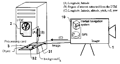
The imaging-based surveillance system 100 described in
conjunction with Figure 4, which is equipped with a classification device (or
classifier), comprises:
-
positioning means 10 such as an inertial navigation system (INS) and
a GPS, integral with the imaging device 1 (optionally a passive
imaging device) serving to determine the angular orientations of the
objects extracted from the images and to position the sensor
according to its geodesic coordinates. It is advantageously appropriate
to ascertain the errors in these information cues so as to be able to
weight the confidence in the membership results to be produced.
- A Digital Terrain Model 2 including the geographical zone covered by
the surveillance system. If the system is required to be loaded aboard
a carrier in motion, it is appropriate to deploy on hard disk DTMs of all
the zones in which the system has to operate.
CA 02785384 2012-06-22
14
- A processing unit 3 integrating a microprocessor and loaded with
software charged with processing the data of the DTM and of the
inertial navigation system so as to position the various objects to be
classified on the various types of backgrounds and thus implement the
method for classifying a new object which will be described further on.
Certain parts of the processing can optionally be embedded on FPGA.
The scheme can be adapted to suit the precision of measurement of
the inertial sensors and of the level of precision of the Digital Terrain
Model.
The principle is not called into question as they evolve, an increase in
precision of these elements allowing, after simple re-parametrization, a gain
in terms of precision of segmentation of the field of view.
The method for classifying a new object operates as follows:
1. The inertial
navigation system 10 measures the following
inertial data C at the level of the imaging device 1 and
transfers them to the processing unit 3: longitude, latitude,
altitude, pitch, roll and yaw. If they are not known a priori and
fixed in the processing unit, the inertial navigation system
can also provide the values of the uncertainties in the above
measurements.
2. The processing unit
3 receives the inertial data C, extracts
the longitude and the latitude A; according to a variant, the
processing unit directly receives a geographical position A
from the positioning means 10 such as a GPS. With the help
of this position A, a zone of interest B (geographical zone
centered on the system) is determined and the altitude data
corresponding to the zone of interest B are then extracted
from the files of the Digital Terrain Module 2, stored in the
storage means (hard disk typically). Preferably, when there
are no altitude data for certain zones of interest B, such as
zones covered by water, the processing unit 3 determines
artificially for these zones, altitude data by 0 values or by the
minimum or mean values of the adjacent zones.
CA 02785384 2012-06-22
3. The processing unit 3 extracts the sensor altitude datum
from the inertial data C and uses it jointly with the zone of
interest B to construct, by projection, an intervisibility map 31
(for each observed direction, this map provides the type of
5 background visible) for the whole of the field of view. This
intervisibility map 31 is illustrated in Figure 3b.
4. The processing unit 3 extracts the roll, pitch and yaw data
from the inertial data C and uses them jointly with the
altitude of the sensor to reference the objects in the same
10 angular coordinate frame as the intervisibility map 31.
5. The processing unit 3 deduces therefrom the type of
background fk to which the object undergoing classification
belongs, and, as a function of the latter information cue,
applies to it the decision rules of the classifier 32 applying to
15 this type of background and defined during the formulation of
the new knowledge database.
The frequency of the operations 1,2,3, on the one hand, and of the
operations 4,5, on the other hand, can differ according to the needs of the
application (carriers in motion, frequencies of the classification requests,
etc.). A typical need is a low temporal frequency for operations 1,2,3
(sufficient when the carrier motion is slow) and a high temporal frequency for
operations 4,5 (the number of objects to be classified is generally large and
the decision-taking times must be short).