Note: Descriptions are shown in the official language in which they were submitted.
CA 02786501 2012-07-05
WO 2011/086149 PCT/EP2011/050446
METHOD TO PROCESS MARINE SEISMIC DATA
TECHNICAL AREA
The present invention concerns the processing of
marine seismic data gathered by means of a seismic
streamer towed by a vessel and comprising a plurality
of receivers. More particularly, the invention concerns
a processing method adapted to the case in which at
least part of the data is acquired at different water
depths, this being possible by using streamers having
at least one portion that is slanted relative to the
water surface, or horizontal streamers located at
different depths.
STATE OF THE ART
One widespread technique used for oil or gas
prospecting consists of conducting a seismic survey of
the subsurface. To image the structure of the sub-
surface, geophysicians use "seismic-reflection"
techniques.
In marine seismics, the technique consists of
towing behind a vessel:
- one or more energy sources for the emission of
an acoustic wave, and
CA 02786501 2012-07-05
2
WO 2011/086149 PCT/EP2011/050446
- seismic receivers arranged on cables called
streamers positioned horizontally at a constant depth
(in the order of Oz = 7.5 metres) to record the
acoustic wave reflected by the interfaces between
geological formations.
The source transmits an acoustic wave to the
water, by setting up a wave field (compression waves)
which propagates coherently and downwardly (downward
propagation) . When the wave field strikes interfaces
between earth formations, called reflectors, it is
reflected through the earth and water as far as the
seismic receivers (upward propagation) where it is
converted into electric signals and recorded.
Seismic receivers are arranged in such manner and
in sufficient number for the recorded signals, called
traces, to form seismic data which can be used to
reconstruct the configuration of the geological layers.
One problem that is encountered is reverberation,
and can be explained as follows. A seismic wave
reflected by a reflector passes through the water in a
generally upward direction. This wave which is called
the "primary" propagates in the water and passes
through the seismic receiver which records its
presence.
The wave field continues its progression towards
the surface of the water (whose reflection coefficient
is -1) where it is reflected downwards. This reflected
wave field or "ghost" is also propagated in the water
and passes through the receivers where it is recorded
once again with reverse polarity and a time lag Lt
which, for waves propagating vertically, is:
Lt = 2hz/c
in which:
CA 02786501 2012-07-05
WO 2011/086149 3 PCT/EP2011/050446
- Lt: the time difference between recording of the
primary wave and ghost respectively by the
receiver,
- Oz: the distance between the streamer and the
water surface,
- c: the rate of propagation of the wave in water
(namely 1500 m/s).
This reverberation of the seismic wave field in
the water affects seismic data by amplifying some
frequencies and by attenuating others, which makes
analysis of underlying earth formations difficult.
In the spectral domain, the ghost corresponds to a
filter transfer function:
G (f) = 1 - exp (2jflfOt)
This transfer function G(f) is zero for multiple
2 750
frequencies f of fn in whichE
These frequencies for which a transfer function is
zero are called "notches". Notches are a particular
hindrance since they cannot be deconvoluted. The
practice followed in seismics is therefore to position
the streamers at a depth such that the first notch lies
outside the useable bandwidth. Since 100 Hz is the
upper limit of the seismic bandwidth, this leads to
positioning the streamers at a depth of around 7.5 m.
However, this relatively low depth for streamers has
the effect of penalizing recording of the low
frequencies (for low frequencies, the function G(f) is
proportional to depth Oz).
Documents US 4 353 121 and US 4 992 992 describe
processing methods with which it is possible to
eliminate ghosts from recorded seismic data by using a
data gathering device comprising a seismic streamer
having an angle (in the order of 2 degrees) with the
water surface.
CA 02786501 2012-07-05
4
WO 2011/086149 PCT/EP2011/050446
With this configuration, it is the operation of
data stacking which ensures the elimination of ghosts.
The acquired data is effectively redundant, and the
processing method comprises a data stacking step to
obtain the final image of the subsurface from redundant
data. It is during the stacking step that the ghost
signals are eliminated since the recordings
contributing towards this stack, which were recorded by
different receivers, display notches at different
frequencies, so that the information that is missing
due to the presence of a notch on one seismic receiver
is obtained from another receiver.
Document US 4,353,121 describes a processing
method based on the following steps:
- determining the common depth point,
- 1D extrapolation (one-dimensional) on a
horizontal surface (called datuming),
- correction for Normal MoveOut (NMO);
- data stacking.
Datuming is a processing method in which, using
the data from N seismic receivers Rn of positions (xn,
zn) where n=1,..N, a synthesis is made of the data that
would have been recorded by the seismic receivers if
they had been placed at the same horizontal positions
xn but at one same constant reference depth zO for all
the seismic receivers.
Datuming is said to be 1D if it is assumed that
the seismic waves propagate vertically. In this case,
the method is limited to applying a static shift to
each time recording recorded by a given seismic
receiver, this static shift corresponding to the time
of vertical propagation between the real depth zn of
the receiver Rn and the reference depth zo.
Also, patent US 4,353,121 describes the method
consisting of obtaining a primary stack by using a NMO
CA 02786501 2012-07-05
WO 2011/086149 5 PCT/EP2011/050446
correction to align reflections, then a ghost stack by
aligning the ghost reflections, then of combining the
two to obtain an after-stack image with a reinforced
single-to-noise ratio.
Similar to US 4,353,121, document US 4,992,992
proposes reconstructing the seismic data which would
have been recorded by a horizontal cable, using the
seismic data recorded by the cable slanted at an angle
relative to the surface of the water.
However, document US, 4,992,992 sets out to take
into account non-vertical propagations by replacing the
1D datuming of US 4,353,121 with 2D datuming.
This 2D datuming takes into consideration the fact
that wave propagation is not necessarily vertical,
contrary to the assumption followed for 1D datuming
such as proposed in US 4,353,12.
More specifically, US 4,992,992 describes a
processing method which, using data recorded by the N
receivers Rn of index n+1,..N lying at a horizontal
distance xn from the source and at a depth zn=zo+zntga
(a corresponding to the angle between the cable and the
water surface, and tg is the tangent trigonometric
function), reconstructs the seismic data which would
have been recorded by seismic receivers located at the
same horizontal positions xn but at one same constant
reference depth zo for all the seismic receivers.
To do so, two sets of seismic data reconstructed
as if they had been recorded by a horizontal streamer
are calculated then stacked after multiplication by a
factor.
The first set of data is synthesized assuming that
the seismic waves propagate upwards like the primary
waves, the second by assuming that the seismic waves
propagate downwards like the ghosts.
CA 02786501 2012-07-05
WO 2011/086149 6 PCT/EP2011/050446
Upward propagation (up-travelling wave) is defined
by propagation angles relative to the horizontal of
between 0 and 1800, downward propagation (down-
travelling wave) by propagation angles of 180 to 360 .
The methods described in US 4,353,121 and US
4,922,922 are one dimensional (1D) and two-dimensional
(2D) seismic processing methods. Yet, said methods are
not generalized in three dimensions. Sampling of the
sensors in the 3rd dimension is effectively given by
the lateral distance between the streamers, in the
order of 150 m, which is much larger than the sampling
of sensors along the streamers which is in the order of
12.5 m.
One general purpose of the present invention is to
provide a 3D seismic processing method which can be
used to image the geology of the subsurface, from
marine seismic data recorded by seismic receivers of
which at least some lie at different water depths,
without involving a datuming step and without any
restrictions regarding the direction of wave
propagation.
PRESENTATION OF THE INVENTION
For this purpose, the invention proposes a method
to process marine seismic data gathered by means of at
least one seismic streamer towed by a vessel, and
comprising a plurality of seismic receivers (R1r...,
Rn) located at respective water depths ( z1r ... , zn)
characterized in that it comprises an adapted mirror
migration step of said data in which the recordings of
the different seismic receivers (R1r...,Rn) at their
effective positions are added to the migration, whilst
adding the opposite of the same recordings at their
mirror positions.
CA 02786501 2012-07-05
7
WO 2011/086149 PCT/EP2011/050446
DESCRIPTION OF THE FIGURES
Other characteristics and advantages of the
invention will become further apparent from the
following description which is solely illustrative and
non-limiting and is to be read with reference to the
appended drawings in which:
- figure 1 is a schematic illustration of a marine
seismic data gathering method;
- figure 2 is schematic overhead view of the
method illustrated figure 1;
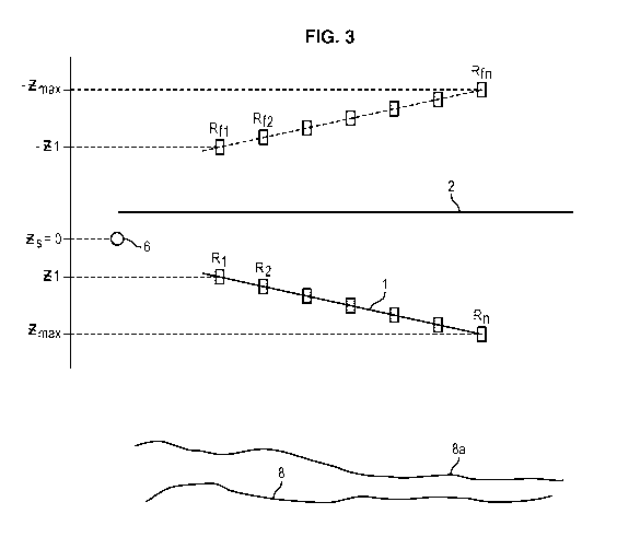
- figure 3 schematically illustrates a mirror
migration step of the processing method.
DETAILED DESCRIPTION OF ONE EMBODIMENT
The marine seismic data processing method will now
be described with reference to the figures.
Gathering of marine seismic data
At the current time, marine seismic data are
recorded by means of an acquisition device in which one
same source position gives rise to the recording of
seismic signals using an array of streamers so as to
cover a geographical area.
In the acquisition mode illustrated figure 1, each
streamer has an angle with the surface of the water, as
proposed in documents US 4,353,121 and US 4,992,992.
This angle is identical for all the streamers of
the array of streamers, so that they globally extend
over one same plane.
Figure 1 shows a body of water extending over a
seafloor with a seismic survey vessel 3 on the surface
of the water 2.
The vessel 3 tows one or seismic sources 6
intended to emit an acoustic wave into the water. The
CA 02786501 2012-07-05
WO 2011/086149 8 PCT/EP2011/050446
source 6 may be an array of compressed airguns, a
marine vibrator or other types of source known to the
person skilled in the art.
The vessel 3 also tows an array of streamers 1
lying at an angle with the surface of the water 2.
Each streamer 1 comprises a plurality of seismic
receivers 4, 5, intended to record the acoustic signals
emitted by the source 6 after their successive
reflections on the interfaces between geological layers
- called reflectors. These seismic receivers 4, 5 are
hydrophones for example.
The acquisition device operates as follows. The
seismic vibration emitted by the seismic source 6
travels along several trajectories 11 and is reflected
at the interfaces between materials of different
acoustic impedance such as interface 8 - the seafloor
is referenced 8a.
A field of reflected waves 12 travels up towards
the surface of the water 2 and is recorded by the
seismic receivers 4, 5.
The hydrophones 4, 5 at the first and second
depths z1r z2 record the reflected waves of the up-
travelling wave field.
However, and as indicated in the section "State of
the art" the recordings are affected by parasitic
reflections: a down-travelling wave field due to
reflection of the waves on the surface of the water 2
is superimposed over the up-travelling wave field 12.
The recordings therefore comprise peaks
corresponding to surface reflections, or parasitic
ghost reflections. The seismic processing method
described below makes it possible to use these
parasitic ghost reflections to image the subsurface.
CA 02786501 2012-07-05
WO 2011/086149 9 PCT/EP2011/050446
Processing of marine seismic data
The method described below uses 3D migration per
shot point with which it is possible to obtain a
precise image of the subsurface taking accurate account
of wave propagation in complex media.
Said migration consists of synthesizing the
incident wave from information on the seismic source,
and the reflected wave from recorded data.
For conventional migration of "one-way" type, the
principle is as follows.
The incident wave D (i.e. the wave emitted by the
source) is assumed to be down-travelling. This incident
wave D (x, y, z, t) is synthesized recursively at depth z,
the down-travelling wave being initialized at the depth
of the seismic source zs. The incident wave D at every
depth nOz is then calculated recursively by calculating
the incident wave at depth z+Oz from the incident wave
at depth z.
Similarly, the reflected wave U (x, y),z, t) is
assumed to be up-travelling and is initialized at z=zr
with the data recorded by the seismic receivers (if all
the receivers have the same depth) . The reflected wave
U in the entire volume is then calculated recursively
by calculating the up-travelling wave U at depth z+Oz
from the up-travelling wave at depth z.
The image of the subsurface is calculated by the
time cross-correlation of the two volumes D (x,y,z,t)
and U (x, y, z, t) .
The altimetry i.e. the fact that the source and
the receivers may have non-zero depths (and all
different) may be taken into account by adding the
sources and receivers at z throughout the recursive
calculations: for example a receiver at a depth Zr
lying between nOz and (n+1)Oz is added during the
recursive calculation of U((n+1)Oz) from U(nLz).
CA 02786501 2012-07-05
WO 2011/086149 10 PCT/EP2011/050446
Also, the migration step is appropriately an
adapted mirror migration, so-called by analogy with
mirror migration and the adapted filter used for signal
processing (consisting of convoluting a measurement
s(t), perturbed by convolution with a h(t) filter, by
h(-t) so as to optimize the signal-to-noise ratio.
For mirror migration, the sea surface is used as
mirror: instead of "sighting" the seafloor, it is the
water surface that is "sighted" to see the reflectors
located underneath the seismic receivers.
In practice, the seismic data are considered not
as having been recorded at the seismic receivers of the
streamer, but at an altitude above the water surface
equal to the depth of each receiver, as illustrated
figure 3.
One mirror imaging technique using mirror
migration is described for example in the publication
"Facilitating technologies for permanently instrumented
oil fields" Dan Ebrom, Xiuyuan Li, and Dwight Sukup,
The Leading Edge, Vol.19, N 3, pp. 282-285, March 2000.
In this publication, this technique is used for
data gathering using seismic receivers located on the
seafloor 8a. The principle used is the principle of
reciprocity, and fictitious consideration is therefore
given to sources on the seafloor (at the receiver
positions) and of receivers on the surface (at the
source positions).
Mirror imaging consists of using the fictitious
ghost source to obtain the image, which can be achieved
by placing the fictitious sources at their mirror
position relative to the water surface, the source
positions (xs, ys, zs, ) being changed to (xs, ys, -zs) .
Mirror imaging allows better illumination of
shallow reflectors.
CA 02786501 2012-07-05
11
WO 2011/086149 PCT/EP2011/050446
With respect to adapted mirror migration, applied
to data that is acquired by partly slanted streamers,
(xr),yr, zr) being the positions of the receivers on the
streamers, the reflected wave U (assumed to be up-
travelling) is initialized with altimetry migration at
an altitude -zmaX, zmaX being the maximum depth of the
seismic receivers (the maximum of all Zr) and altitude
0 corresponding to the water surface.
During the recursive downward movement at z of the
wave U between values -zmaX and 0, the recording of the
receiver under consideration is added with a sign
change at the mirror positions of the receivers
relative to the seafloor i . e . at (xr, yr), -Zr) .
Continuing downwards for z=0 to zmaX, the
recordings of the receiver under consideration are
added at their real positions (xr, yr, Zr) . The remainder
of the recursive calculation of U, the generation of
the incident wave D (assumed to be down-travelling) and
the cross-correlation step between incident and
reflected wave to obtain the image, are conducted in
similar manner to a conventional one-way migration.
In this manner the image of the subsurface is
obtained directly from 3D acquisitions by slanted
streamers, taking into account the exact positions of
the receivers and the exact 3D propagation of the
waves.
The step, during which recordings are added at the
mirror positions of the receivers, whose extra cost is
negligible, provides strengthening of the signal-to-
noise ratio by an image based on the ghost receiver,
without doubling the migration calculation time which
would be the case if two images were calculated and
then stacked as proposed in "Facilitating technologies
for permanently instrumented oil fields". However, said
CA 02786501 2012-07-05
12
WO 2011/086149 PCT/EP2011/050446
solution could be applied in one variant of embodiment
of the method.
The invention described above allows an image of
the subsurface to be obtained directly from data
derived from 3D acquisition, gathered using several
slanted streamers.
Contrary to the methods described in US 4,353,121
and US 4,992,992 the processing method described above
does not comprise any datuming step - consisting of
reconstructing seismic data which would have been
recorded by a horizontal streamer, using seismic data
recorded by the slanted streamer, prior to their
migration.
The processing method described above takes into
account the angles of propagation at both x and y.
This method also makes it possible to improve the
signal-to-noise ratio by using ghost data to reinforce
primary reflection data.
If the diversity of depths of the sensors does not
permit ghost waves to be fully eliminated, the
resulting perturbation on end data is convolution by a
filter that is symmetrical (zero phase) and can be
deconvoluted (no notch) . This deconvolution step is
simplified by the fact that it is a zero phase
deconvolution.
The description of adapted mirror migration given
above concerns the case of 3D migration for "one-way"
shot point. There are other types of migrations which
can be adapted as adapted mirror migration by adding to
the calculation of the reflected wave, in addition to
the recordings of the receivers at their exact
positions, the opposite recordings at their mirror
positions.
There is also a 3D migration per shot point called
"Reverse Time Migration" which does not assume that the
CA 02786501 2012-07-05
WO 2011/086149 13 PCT/EP2011/050446
incident wave is a down-travelling wave and the
reflected wave an up-travelling wave. In this case, the
adapted mirror migration can be performed by adding the
receivers at their effective position (xr, yr, Zr) but by
using at the water surface so-called free-surface
boundary conditions instead of the usually used
absorbing boundary conditions.
The methods described above are not limited to the
processing of data acquired using linear streamers of
constant slant as shown figure 1. They can just as well
be applied to data gathered by means of streamers each
comprising several sections of different slants, or by
streamers having one or more slanted sections and one
or more horizontal sections, or by horizontal streamers
located at different depths.