Note: Descriptions are shown in the official language in which they were submitted.
CA 02787970 2015-06-16
SYSTEMS AND METHODS FOR
MODELING 3D GEOLOGICAL STRUCTURES
CROSS-REFERENCE TO RELATED APPLICATIONS
[0001] The priority of U.S. Patent Application No. 12/710,253, filed on
February 22,
2010, is hereby claimed.
STATEMENT REGARDING FEDERALLY SPONSORED RESEARCH
[0002 ] Not applicable.
FIELD OF THE INVENTION
[0003 ] The present invention generally relates to modeling three-dimensional
(3D)
geological structures. More particularly, the present invention relates to an
integration
method for maximum continuity interpolation in 3D geological modeling.
BACKGROUND
[0004 ] Conventionally, geostatistical software describes the pattern of
spatial
variation in geological properties (e.g. porosity and permeability) using a
variogram model
that quantifies the average of expected variability as a function of distance
and direction. In
reservoirs, where the geological characteristics are very continuous and
easily correlated
from well to well, the range (or scale), of correlation will be large and in
reservoirs, where
the geological characteristics change quickly over short distances, the range
(or scale) of
correlation will be smaller.
[0005] In certain geological environments, the range of correlation may be
directionally independent. This phenomenon is very common in sedimentary
environments,
especially in those where the primary mechanism of transport during sediment
deposition is
wind or water, which results in highly channelized structures such as deltaic
channels,
fluvial
1
CA 02787970 2012-07-23
WO 2011/102922
PCT/US2011/020569
deposits, turbidites and the like. These environments usually demonstrate a
large degree of
correlation variation between directions along the channel axis and
perpendicular to the
channel axis. The principles of conventional geostatistical practice, embedded
in the
majority of commercial tools for geological modeling presently available on
the market,
require selection of a single direction of maximum continuity, which is an
average for the
entire domain under study.
[00061 Traditional reservoir modeling techniques use simplified two-point
statistics
to represent geological structures with complex geometrical configurations,
such as deltaic
channels, fluvial deposits, turbidites and shale drapes. The two-point
correlation is modeled
through the definition of a variogram, which makes the description of the
above-mentioned
structures highly challenging if not impossible. One benefit of two-point
geostatistical
methods is their speed. One technique, for example, utilizes the Fourier-
filter based method.
which is described in an article written by M. Maucec, et. al. called
"Streamline-based
History Matching and Uncertainty: Markov-Chain Monte Carlo Study of an
Offshore
Turbidite Oil Field," and is capable of generating a new realization of
permeability field with
large numbers of variables (-106) within a few seconds. Although this
technique is more
efficient than traditional well-known algorithms, like Cholesky decomposition,
it is not
suitable for integration into workflows for dynamic inversion and automated
history
matching of reservoir models due, in part, to its dependence on the use of
variogram
de tin it ion.
100071 Within the last decade, advances have been made in the form of multi-
point
ueostatistics (MPS). MPS technology uses correlations between multiple
locations at the
same time to reproduce = volume-variance relationship and model realizations,
which are
CA 02787970 2015-06-16
conditioned to local sample data. Examples of MPS technology combine codes
like
SNESIM and S-GeMS. The latter, for example, is dedicated to the local
optimization of
parameters involved in variogram-based models to take into account local
structural
characteristics of the data. MPS technology, however, still has its
disadvantages such as, for
example: a ) dependence on the training image or training data set; and b)
very long
computational times for generating new geological model/realization.
[0008] More recently, Landmark Graphics has developed technology for three-
dimensional volumetric modeling of geological properties using a Maximum
Continuity
Field (MCF). This technology is more commonly referred to as Point Vector
technology,
which is described in International Patent Application Publication No.
W02009/151441.
The Point Vector technology introduces several advantages that enable a user
to: i) direct
control over local continuity directions; ii) interactively operate with
"geologically
intuitive" datasets, such as layering intervals, projection maps and hand
drawings through a
MCF; and iii) retain the maximum fidelity of a geological model by postponing
the creation
of a grid/mesh until the final stage of static model building immediately
before integrating
the static model into a dynamic model (reservoir simulator). The reservoir
property
modeling does not need a standard grid but only the correct distance between
the points to
estimate/simulate the property and the data around it.
[0009] The current Point Vector technology basically introduces a solution,
commonly referred to as an "80% solution," which is based on the approach of
simply
reorienting the axes of a variogram model to the local direction specified by
the user. In
geological structures with a high degree of local anisotropy (e.g. meandering
channels), the
3
CA 02787970 2012-07-23
WO 2011/102922
PCT/US2011/020569
direction of maximum continuity significantly changes locally for highly
meandering
channels. The 80% solution has no way of knowing how to look beyond the
channel corner.
The estimation of the correct distance in such geological structures requires
the introduction
of curvilinear distances because the minimum distance between two points in
geological
formations is not always a straight line (i.e. Euclidean distance) and may be
curvilinear ¨
depending on the local anisotropy field. The remaining challenges are: i) how
to calculate
the shortest distance between two points of interest in a grid-less model of a
geological
structure; and ii) which direction/orientation to use to correctly describe
the local anisotropy
effects.
SUMMARY OF THE INVENTION
100101 The present invention meets the above needs and overcomes one or more
deficiencies in the prior art by applying an integration method to calculate
the shortest'
distance between two points of interest in a grid-less model of a geological
structure and to
determine which direc6on/orientation to use for correctly describing the local
anisotropy
effects.
[00I1] In one embodiment, the present invention includes a method for modeling
a
three-dimensional ("3D") geological structure that comprises: i) selecting
input data for the
geological structure; ii) digitizing an image of the geological structure
represented by the
input data, the digitized image comprising multiple sample points; iii)
processing the
digitized image using intelligent point densification to only initialize a
location for each
sample point and optimize each sample point location; iv) calculating a
structure and
diffusion tensor field for the digitized image, each tensor for the tensor
field being linked
with a respective sample point at an optimized sample point location for the
respective
4
CA 02787970 2012-07-23
WO 2011/102922
PCT/US2011/020569
sample point; v) processing the digitized image using structure-oriented
smoothing to form
an enhanced image; vi) calculating a fault displacement field for the
digitized image; and vii)
interpolating the structure and diffusion tensor field, the enhanced image and
the fault
displacement field to produce a 3D geological model.
[0012] In another embodiment, the present invention includes a computer
readable
medium for storing computer executable instructions for modeling a three-
dimensional
("3D") geological structure. The instructions are executable to implement: i)
selecting input
data for the geological structure; ii) digitizing an image of the geological
structure
represented by the input data, the digitized image comprising multiple sample
points; iii)
processing the digitized image using intelligent point densification to only
initialize a
location for each sample point and optimize each sample point location; iv)
calculating a
structure and diffusion tensor field for the digitized image, each tensor for
the tensor field
being linked with a respective sample point at an optimized sample point
location for the
respective sample point; v) processing the digitized image using structure-
oriented smoothing
to form an enhanced image; vi) calculating a fault displacement field for the
digitized image;
and vii) interpolating the structure and diffusion tensor field, the enhanced
image and the
fault displacement field. to produce a 31) geological model.
[0013] Additional aspects, advantages and embodiments of the invention will
become
apparent to those skilled in the art from the following description of the
various embodiments
and related drawings.
BRIEF DESCRIPTION OF THE DRAWINGS
[0014] The present invention is described below with references to the
accompanying
drawings in which like elements are referenced with like reference numerals,
and in which:
CA 02787970 2012-07-23
WO 2011/102922
PCT/US2011/020569
[0015] FIG. I is a flow diagram illustrating one embodiment of a method for
implementing the preset invention.
[0016] FIG. 2 is a flow diagram illustrating one embodiment of a method for
implementing step 106 in FIG. I.
[0017] FIG. 3 is a schematic illustration of a maximum continuity vector.
[0018] FIG. 4A is a schematic diatzram illustrating the application of Point
Vector
technology for tracing a Maximum Continuity Field over a fault line.
[0019j FIG. 413 is a seismic data image illustrating the loss of directional
information
as a result of using the Point Vector technology.
[0020] FIG. 5A is a seismic data image illustrating a fault displacement field
calculated according to step 205 in FIG. 2.
[0021J FIG. 513 is an enlarged image of the area circled in FIG. 5A
illustrating the
directional information for the fault displacement field.
[0022] FIG. 6 is a schematic diagram comparing Curvilinear distance and
Euclidean
distance for illustrating step 108 in FIG. 1.
[00231 FIG. 7 is a block diagram illustrating one embodiment of a system for
implementing the present invention.
DETAILED DESCRIPTION OF THE PREFERRED EMBODIMENTS
[0024] The subject matter of the present invention is described with
specificity.
however, the description itself is not intended to limit the scope of the
invention. The subject
matter thus, might also be embodied in other ways, to include different steps
or combinations
of steps similar to the ones described herein, in conjunction with other
technologies.
Moreover, although the term "step" may be used herein to describe different
elements of
6
CA 02787970 2012-07-23
WO 2011/102922
PCT/US2011/020569
methods employed, the term should not be interpreted as implying any
particular order
among or between various steps herein disclosed unless otherwise expressly
limited by the
description to a particular order.
Method Description
[0025] The following description includes one or more methods (hereinafter
generally referred to as an "integration method") for integrating the Point
Vector technology
and curvilinear point-to-point (CPP) interpolation techniques,- which are well
known in the
art, through data abstraction to merge a broad range of available datasets and
structures. An
image digitization platform is disclosed with a generic I/O data stream, which
is unified for
interpolation. The integration method provides a unique tool in the field of
31) geological
modeling.
[0026] Referring now to FIG. 1, a flow diagram illustrates one embodiment of a
method 100 for implementing the present invention. The method 100 represents
an
integration method for 3D geological modeling, which accounts for multiple
sources and
types of geological and structural intbrmation. Such information may include,
for example,
intuitive hand drawings of structural frameworks and high-resolution seismic
data images.
[0027] In step 102, structural information such as, for example, high-
rcsolution
seismic data, may be selected as input data for the method 100 using the
client interface
and/or the video interface described in reference to FIG. 7. The seismic data
may contain
structural information used for CPP interpolation and structure-oriented
smoothing.
[0028] In step 104, other types and formats of geological and structural
information
such as, for example i) layering intervals (104a), which represent a vertical
space hounded by
2 geological surfaces; ii) map views (104h) of channel limits: and iii)
intuitive hand drawings
7
CA 02787970 2012-07-23
WO 2011/102922
PCT/US2011/020569
(1040 of structural frameworks (e.g. vectors in a specific portion of a volume-
of-interest)
may be selected as input data for the method 100 using the client -interface
and/or the video
interface described in reference to FIG. 7. The geological and structural
information
selected in step 104 may be based on a single direction of maximum continuity
using a
Maximum Continuity Field in the manner described in International Patent
Application
Publication No. W02009/151441 Al. By definition, the direction of maximum
continuity is
the direction alone which the property of interest is the most likely to stay
the same when
moving away from the location of the vector along the direction of the vector
as illustrated in
FIG. 3. In other words, it defines implicit relations between locations in the
geological .
model for property modeling purposes.
100291 In FIG. 3, a maximum continuity vector 302 has a location 304, a
magnitude.
a direction and a correlation. (length) 306. The correlation (length) of the
vector 302
coincides with the lone range of the variogram model. To preserve the vector
information in
channelized, highly meandering geological structures with a high degree of
local anisotropy,
the axes of the variogram model could be intuitively reoriented to the
specified local
direction in the manner proposed in International Patent Application
Publication No.
W020091151441 Al.
100301 In step 106, data abstraction is performed on the input data selected
in steps
102 and/or 104 in the manner further described in reference to FIG. 2. Data
abstraction is
performed because the input data selected in steps 102 and/or 104 usually
appear in very
different modes or resolution and, in order to deploy the input data during
the interpolation
step 108, a generalization or abstraction of the input data is required.
8
CA 02787970 2012-07-23
WO 2011/102922
PCT/US2011/020569
[00311 In step 108, CPP interpolation such as, for example, natural-neighbor
interpolation or image-guided-blended-neighbor interpolation is performed on
the results
from step 106. In one embodiment, the interpolation applies a two-step
blending of tensor
field data: I) any anisotropic Eikonal equation, which is well known in the
art, is solved for
the minimum travel time from a sampled point to a known data point (i.e. well
data/location)
by methods well known in the art such as, for example, the Dijkstra-based Fast
Marching
Method (FMM); and 2) an iterative conjugate-gradient method, which is well
known in the
art, is used to solve for a blended neighbor interpolant, which is a
derivation of a pressure
equation. The integration of an underlying structure/diffusion tensor field
and structure-
oriented anisotropy smoothing postulates an important analogy between the
Point Vector
technology and CPP interpolation: correlation (length or range) of a maximum
continuity
vector is proportional to the maximum eitzenvalue of diffusion tensor D, which
is aligned
with the structural orientation (i.e. dominant direction of structure tensor
or local linear
diffusivity). The main idea is to align the principal axes of diffusion with
the orientation of
the image. The diffision tensor D should be constructed such that its
eigenveetors lllov
local orientation of the image.
[0032] When applied to geological modeling, standard, Euclidean-based, point-
to-
point interpolation of reservoir properties could yield erroneous results
because complex-
underlying geological structures (e.g. channels) are not honored. In other
words, Euclidean-
based interpolation does not honor sinuosity, which is a prevalent feature of
a meandering
channel. By blending the tensor field data (e.g. stnicture/diffusion) to .
guide the
interpolation, a major improvement in the physical accuracy of geological
modeling is
achieved. As illustrated in FIG. 6, this is achieved by solving the
curvilinear distance 604.
9
CA 02787970 2016-01-14
The curvilinear distance 604 represents a constrained Euclidean distance
between two
points (i,y) along an optimal trajectory. The curvilinear distance 604 may be
solved using:
< tn,(y) where t and tm represent the time (t) at (5-c,y) and the minimal
travel time (tm)
at (p), respectively. Optionally, the curvilinear distance 604 may be solved
using the
solution to the anisotropic Eikonal equation for a minimum travel time (tm)
along the
optimal trajectory. The Euclidean distance 602 solves for the linear distance
between two
points and and is inaccurate for channelized features.
[0033] To date, CPP interpolation has only been implemented using a seismic
data
image as the underlying structural input. The integration method therefore,
brings together
other types and formats of geological and structural data (e.. layering
intervals, projection
maps and hand drawings) as the input data for interpolation.
[0034] Referring now to FIG. 2, a flow diagram illustrates one embodiment of a
method 200 for implementing step 106 in FIG. 1.
[0035] In step 201, an image of a geological structure represented by the
input data
is digitized using any standard method well known in the art for representing
an image by a
discrete set of its points or samples such as, for example, rasterizing or
image compression.
The fundamental feature is to render a generic image format compatible with
interpolation
in step 108.
[0036] In step 202, the digitized image from step 201 is processed using
intelligent
point densification (IPoD). IPoD is an improvement of the atomic-meshing
techniques
described in U.S. Pat. No. 7,050,612. IPoD is generally used to: 1) initialize
the sample
point location by filling the space spanned by the digitized image with a
pseudo-regular
lattice of points, where the nominal distance between
CA 02787970 2012-07-23
WO 2011/102922
PCT/US2011/020569
the point and its nearest neighbors varies consistently with the density of
structural features
in the digitized image; and 2) optimize the sample point location by moving
the points within
the space spanned by the digitized image to minimize a total potential energy,
defined to be a
weighted sum of a point potential energy for each sample point and a potential
energy for the
digitized image. The details of the sample point initialization and
potential energy
minimization algorithms are given in U.S. Patent No. 7,950,612. The advantages
of IPoD
over standard atomic meshing is that it is used strictly for the
initialization and optimization
of sample point location. In this manner, the step of generating the actual
triangulated mesh
is omitted. The standard atomic meshing method connects the optimized sample
points
location by triangulation, which may be Delaunay triangulation or any other
standard
technique for triangulation, that is well known in the art, to form a mesh of
sample points.
lowever, generating a triangulated mesh is a computationally demanding
procedure and may
require special rendering techniques to correct for artifacts as described in
the article written
by A. Ruegeir and D. Hale called "Meshing for Velocity Modeling and Ray-
Tracing in
Complex Velocity Fields." According to Point Vector technology, the sample
points are
generated on a regular square grid and are randomly or evenly distributed
within the volume-
of-interest (V01). Because I PoD is computationally less demanding than atomic
meshing. it
is anticipated that IlloD will. generate about 1/300th the number of sample
points than
generated using the PointNector technology. On a typical seismic data image,
this can result
in an increase in computational speed by a factor of 300.
= [00371 In step 203, a structure and diffusion tensor field is calculated
for the digitized
image from step 201 using methods \'ell known in the art. The individually
calculated
tensors for the tensor field are linked with the corresponding sample point
initialized and
I I
CA 02787970 2012-07-23
WO 2011/102922
PCT/US2011/020569
optimized in step 202 by IPoD. If' the technique applied is the "nearest
neighbor" search,
then the tensor is linked to the nearest neighbor sample point, lithe
technique applied is the
"natural neighbor" search, then the tensor is linked to the natural neighbor
sample point.
Both the nearest-neighbor search and natural-neighbor search techniques are
well known in
the art. The metric tensor field is the link between distance and time and
represents the
coherence, orientation and dimensionality of features in the image, which
guide the
interpolation in step 108. The tensor field alters interpolation so that known
sample values
within spatially coherent image features are given more weight than values on
opposite sides
of such features or where the image is less coherent. Any underlying tensor
field needs some
underlying guiding representation in a computer such as, for example, a
drawing,
photograph, or other image. If derived from a seismic data image, the tensor
field might be
sampled with resolution of the seismic data image. Alternatively, the tensor
field may be
sampled more coarsely/cleverly using, for example, IPoD. This means that the
tensor field
will be sampled with the lower resolution only at the image locations
determined by the
optimized locations or the sample points from step 202.
[00381 In step 204, the digitized image from step 201 is processed using
structure-
oriented smoothing alone structures that are apparent in the image (i.e.,
calculated in the
form of a structure and diffusion tensor field in step 203), which enhances
structural features
and preserves important discontinuities such as, for example, faults or
channels. For this
step, a broad spectrum of well-known filtering algorithms may be used such as,
for example:
i) coherency-enhancing anisotropic filters: ii) structure-oriented
interpretation filters (i.e. van
Gogh filters); iii) recursive (anisotropic) Gaussian filters; and iv) novel
implementations of
bilateral filters.
CA 02787970 2012-07-23
WO 2011/102922
PCT/US2011/020569
[00391 In step 205, a fault displacement field (FDF) for the digitized image
from step
201 is calculated in the manner described below. The FDF is merged with the
results from
step 203 and step 204, which is returned to step 108 in FIG. 1 for
interpolation. Traditional
seismic interpretation methods focus on the detection of the fault line in the
seismic data
image through, for example, coherence methods. Calculating an FDF, however,
corresponds
to tracing the .MCF through the fault line (in 21)) or through the fault
surface (in 3D). Here,
the problem is addressed from the perspective of calculating the displacement
vector field on
the digitized image and extracting the fault-displacement component of such
field based on a
criterion which, for example, distinguishes between the fault throw and a
dipping layer. In
this tmanner, step 205 may be applied to fault line/surface detection in the
seismic data image
as well as to any other format of digitized data pertaining to structural
information (e.g.,
layering intervals, projection .maps and hand drawings).
[00401 The FIN is therefore, calculated by searching for the apparent
displacement
vectors in the image and searching for the locations of peaks of local cross-
correlations
between adjacent, that is vertical, image traces. The FDF constrains fault
vectors, which vary
smoothly within a fault that is in the direction of the fault. As a
generalization to non-vertical
faults, a correlation smoothing window is applied, which is aligned with a lag
vector. In
other words, smoothing is applied 1Or any lag vector in the direction of that
vector by
shearing where the correlation is done trace-by-trace and is as fast as if it
was done for the
vertical faults. Shearing is a well known concept used in computer graphics
algorithms.
[00411 Referring now to FIG. 4A, the application of the Point Vector
technology is
illustrated fir tracing the data-searched region 404a and the associated MCF
408a over a
thult line 400a from region 404a to region 406a by displaying region 404a of
the search and
13
CA 02787970 2012-07-23
WO 2011/102922
PCT/US2011/020569
following the fault throw vector 402a to region 406a. Because this operation
has to be
performed on multiple-fault lines in a VOI for the entire MCF, it is extremely
time-
consuming and hard to efficiently implement in practice. As illustrated in
FIG. dll which is
a 2D seismic data image representing amplitude, the calculated structure and
diffusion tensor
field, represented by the ellipsoids, does not continue through the fault
line. The areas
represented by 402b, 4041) and 406b reveal the areas where the directional
information is
lost. In other
words, as the ellipsoids become less elongated, the information on
directionality of the tensor field is lost on the fault line and discontinues
tracing the MCI'.
By calculating the FIN in step 205, tracing the MCF over fault lines is
generically applicable
to any underlying structural representation in a digital image. Step 205
represents an
improvement over the Point Vector technology, which does not require user pre-
defined
input for fault vectors and associated fault throws, which are required by the
use of the Point
Vector technology.
100421 Referring, now to FIG. 5A, a seismic data image illustrates a fault
displacement field calculated according to step 205 on amplitude seismic data.
[0043] Referring now to FIG. 513, an enlarged image of the area circled in
FIG. 5A
illustrates the directional information for the fault displacement field.
For clarity,. the
directionality information (i.e., vector arrows) are shown in FIG. 513. The
vector arrows
represent the calculated displacement vectors. It is evident from the absolute
length or the
vector arrows that the displacement is merely associated with the high-
gradient-change
features (e.g. fault throws), but not with the tilt variation of horizontal
layering where the
length or the vector arrows is reduced. This is the preferred behavior because
the
displacement vector field is envisioned as the structural property.
14
CA 02787970 2012-07-23
WO 2011/102922
PCT/US2011/020569
[00441 The present invention is distinguished from existing technologies on
the
market by the integration of: i) Maximum Continuity Fields (MCF); ii)
Intelligent Point
Densification (1PoD); iii) fault displacement fields (FIN); and iv) CPP
interpolation. The
integration method of the present invention therefore: i) describes the local
anisotropy effects
by introducing the Maximum Continuity Field and Fault Displacement Field based
on
underlying structural information and ii) introduces the CPI interpolation
techniques to
perform the interpolation between two points of interest along the direction
of maximum
continuity and across the fault surfaces.
System Description
[00451 The present invention may be implemented throligh a computer-executable
program of instructions, such as program modules, generally referred to as
software
applications or application programs executed by a computer. The software may
include, for
example, routines, programs, objects, components, and data structures that
perform particular
tasks or implement particular abstract data types. The software forms an
interface to allow a
computer to react according to a source of input. DecisionSpace Earth Modeling
(DSEM),
which is a commercial software application marketed by Landmark Graphics, may
be used as
an interface application to implement the present invention. The software may
also
cooperate with other code segments to initiate a variety of tasks in response
to data received
in conjunction with the source of the received data. The software may be
stored and/or
carried on any variety of memory media such as CD-ROM, magnetic disk, bubble
memory
and semiconductor memory (e.g., various types of RAM or ROM). Furthermore, the
software and its results may be transmitted over a variety of carrier media
such as optical
fiber, metallic wire and?or through any of a variety of networks such as the
Internet.
CA 02787970 2012-07-23
WO 2011/102922
PCT/US2011/020569
[0046] Moreover, those skilled in the art will appreciate that the invention
may be
practiced with a variety of computer-system configurations, including hand-
held devices,
multiprocessor systems, microprocessor-based or programmable-Consumer
electronics,
minicomputers, mainframe computers, and the like. Any number of computer-
systems and.
computer networks are acceptable for use with the present invention. The
invention may be
practiced in distributed-computing environments where tasks are performed by
remote-
processing devices that are linked through a 'communications network. In a
distributed-
computing environment, program modules may be located in both local and remote
computer-storage media including memory storage devices. The present invention
may
therelbre_be implemented in connection with various hardware, software or a
combination
thereof, in a computer system or other processing system.
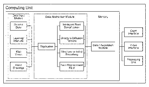
[0047] Referring now to FIG. 7, a block diagram of a system for implementing
the
present invention on a .computer is illustrated. The system includes a
computing unit,
sometimes referred to a computing system, which contains memory, application
programs, a
client interInce, a video interlace and a processing unit. The computing unit
is only one
example of a suitable computing environment and is not intended to suggest any
limitation as
to the scope of use or functionality of the invention.
[0048] The memory primarily stores the application programs, which may also be
described as program modules containing computer-executable instnictions.
executed by the
computing unit for implementing the present invention described herein and
illustrated in
FIGS. 1-2. The memory therefore, primarily includes a data input module, an
abstraction
module and a data interpolation module, which enable the methods illustrated
and described
in reference to FIGS. 1-2. The data input module includes functionality
supporting the input
16
CA 02787970 2012-07-23
WO 2011/102922
PCT/US2011/020569
of seismic data, layering/intervals, map views and hand drawings. In other
words, the data
input module integrates with DSEM,. and the client/video interfaces to execute
the functions
described in reference to steps 102a, 104a, 104h and 104c in FIG. 1. The data
abstraction
module integrates with DSEMw to execute the functions described in reference
to step 106 in
FIG. 1. In particular, the data abstraction module includes digitization,
intelligent point
densification, structure/diffusion tensors, structure-oriented smoothing and a
fault
displacement field components to execute the functions described in reference
to steps 201-
205 in FIG. 2. The data interpolation module integrates DSEM- to execute
the
functions described in reference to step 108 in FIG. 1.
[0049] Although the computing unit is shown as having a generalized memory,
the
computing unit typically includes a variety of computer readable media. By way
of example,
and not limitation, computer readable media may comprise computer storage
media. The
computing system memory may include computer storage media in the form of
volatile
and/or nonvolatile memory such as a read only memory (ROM) and random access
memory
(RAM). A basic input/output system (BIOS), containing the basic routines that
help to
transfer information bemeen elements within the computing unit, such as during
start-up, is
typically stored in ROM. The RAM typically contains data and/or program
modules that are
immediately accessible to and/or presently being operated on by the processing
unit. By way
of example, and not limitation, the computing unit includes an operating
system, application
programs, other program modules, and program data.
[0050] The components shown in the memory may also be included in other
removable/nonremovable, volatile/nonvolatile computer storage media or they
may be
implemented in the computing unit through application program interface
("API"), which
17
CA 02787970 2012-07-23
WO 2011/102922
PCT/US2011/020569
may reside on a separate computing unit connected through a computer system or
network.
For example only, a hard disk drive may read from or write to nonremovable,
nonvolatile
magnetic media, a magnetic disk drive may read from or write to a removable,
non-volatile
magnetic disk, and an optical disk drive may read from or write to a
removable, nonvolatile
optical disk such as a Cl) ROM or other optical media. Other removable/non-
removable,
volatile/non-volatile computer storage media that can be used in the exemplary
operating
environment may include, but are not limited to, magnetic tape cassettes,
flash memory
cards, digital versatile disks, digital video tape, solid state RAM, solid
state ROM, and the
like. The drives and their associated computer storage media discussed above
provide
storage of computer readable instructions, data structures, program modules
and other data
for the computing unit.
[0051] A client may enter commands and information into the computing unit
through the client interface, which may be input devices such as a keyboard
and pointing
device, commonly referred to as a mouse, trackball or touch pad. Input devices
may include
a microphone, joystick, satellite dish, scanner, or the like. These and other
input devices are
often connected to the processing unit through a system bus, but may be
connected by other
interface and bus structures, such as a parallel port or a universal serial
bus (USB).
[00521 A monitor or other type of display device may be connected to the
system bus
via an interface, such as a video interface. A graphical user interface
("GUI") may also be
used with the video interface to receive instructions from the client
interface and transmit
instructions to the processing unit. In addition to the monitor, computers may
also include
other peripheral output devices such as speakers and printer, which may he
connected
through an output peripheral interface.
18
CA 02787970 2015-06-16
[0053] Although many other internal components of the computing unit are not
shown, those of ordinary skill in the art will appreciate that such components
and their
interconnection are well known.
[0054] While the present invention has been described in connection with
presently
preferred embodiments, it will be understood by those skilled in the art that
it is not
intended to limit the invention to those embodiments. It is therefore,
contemplated that
various alternative embodiments and modifications may be made to the disclosed
embodiments without departing from the scope of the invention defined by the
appended
claims and equivalents thereof.
19