Note: Descriptions are shown in the official language in which they were submitted.
CA 02788753 2012-07-31
WO 2011/094860 PCT/CA2011/000153
- 1 -
MEASUREMENT OF THE SURFACE SHAPE MAP OF FLAT AND CURVED
OBJECTS, INDEPENDENT OF RELATIVE MOTIONS
TECHNICAL FIELD
This invention relates to a method and system that can measure the surface
shape
map of an object that is moving longitudinally relative to the apparatus,
independent of
relative motions in the measurement directions. Such measurements are useful
for surface
quality control of manufactured products, for example sawn lumber and logs,
rolled metals
and highway pavements.
BACKGROUND OF THE INVENTION
Surface shape measurement is an important need in many industrial and
scientific
applications. Typical examples include flatness inspection of road surfaces,
quality
control of manufactured products such as sawn lumber and rolled metal, and
shape
determination of complex shaped objects such as logs.
A simple way to measure surface shape profile is to make a series of
measurements
using a distance sensor while relatively moving the measured object and the
sensor in a
straight line perpendicular to the measurement direction. FIG. 1(a)
schematically shows an
example arrangement for a surface shape along a single line. The drawback to
this method
is that deviations from straight-line motion cause relative displacements in
the measurement
direction that are indistinguishable from measured surface shape. Thus, very
accurate
linear motion is essential.
In many cases, accurate linear motion is not practicable. For example, when
measuring the surface profile of a highway pavement, it is generally not
feasible to provide
a separate linear slide for moving the sensor. Instead, the sensor must travel
on the irregular
pavement that it is measuring.
US Patent 5,280,719 describes an apparatus that uses a large number of equally
spaced sensors. The apparatus seeks to identify long surface features by
overlapping the
sets of measurements made at successive intervals much less than the total
spacing of the
sensors. However, the large number of sensors that are required creates a
large cost and
CA 02788753 2012-07-31
WO 2011/094860 PCT/CA2011/000153
- 2 -
maintenance burden. US Patent 4,573,131 describes a method of using just four
sensors
to achieve the same objective. The sensors make successive measurements at
small
intervals of travel. The described method is based on the assumption that
successive
sensors reaching the same point along the measured line have the same distance
from the
measured surface. This is typically not a reasonable assumption, and the
described
method has only limited effectiveness.
The above-mentioned patents disclose methods for measuring surface height
profiles along individual lines on the target object. It is also of great
practical interest to be
able to measure a surface shape map, similar in concept to a topographic map.
Such
measurements can be achieved by replacing the individual distance sensors
shown in Figure
1 ("point sensors") by sensors that measure surface height profile at multiple
points along
lines ("line sensors"). The accumulation of sequential measurements at the
various
intervals along the measured lines creates a surface shape map. Line sensor
measurements
are subject to the same influence of deviations from straight-line motion of
the measured
object during the measurements as point sensors. Canadian Patent 2,297,879
describes a
technique where multiple equally spaced parallel lines are measured, with the
surface shape
identified by overlapping the successive measurements. This approach is a
development of
that used in US Patent 5,280,719, with multiple line sensors replacing
multiple point
sensors. Both techniques have similar limitations. Their lengthwise spatial
resolution is
limited to the distance between the sensors; the use of evenly spaced parallel
sensors makes
the method unsuitable for achieving finer spatial resolution. When doing
measurements
using two line sensors, only surface twist can be identified, but not
lengthwise shape.
None of the above techniques is well suited to making surface shape
measurements
with fine lengthwise spatial resolution. They are also not well suited to
measuring the
surfaces of objects with opposing sides. At best, they can measure each of the
sides
separately, but they do not provide accurate thickness information. The method
described
in US patent 7,003,894 is successful at making fine resolution surface height
profile
measurements and providing accurate thickness information. The method involves
the use
of multiple sensors that make sequential surface height measurements. The
surface height
profile(s) is/are mathematically determined from the measured data by
observing that the
surface height information appears sequentially in the measured data, while
the effects of
CA 02788753 2012-07-31
WO 2011/094860 PCT/CA2011/000153
- 3 -
relative motions occur simultaneously. US patent 7,003,894 describes several
different
possible measurement configurations.
The methodology described in US patent 7,003,894 works well when the number of
surface points to be measured is relatively modest, for example, to determine
surface shape
profiles along one or a small number of chosen lines within the specimen
surface.
However, the computation becomes very burdensome and time consuming when an
entire
surface shape map is desired. The present invention provides a different data
handling
approach that is able to evaluate detailed surface height maps in real time,
that is in an
interval of time less than required for data acquisition. Furthermore, the
method and system
operate independent of relative motion, that is, they are independent of
movements due to
translation, pitch and/or roll that the object may experience when being
mapped.
The various prior methods are difficult to apply to the measurement of
surfaces
that are not approximately normal to the measurement direction because they
focus on
relative motions of the measured object in that normal direction. Thus, the
various
techniques are not well suited to the measurement of the surface shape of non-
flat objects
such as logs. The present invention extends the scope of method described in
US patent
7,003,894 to enable effective surface shape measurements of such non-flat
objects.
SUMMARY OF THE INVENTION
The present invention provides a method for measuring surface shape that
overcomes the limitations of previous art. The invention involves using
multiple sensors
operating simultaneously. The main differences from previous designs are the
way in
which the sensors are geometrically arranged, and the way their measurements
are
combined to determine the desired surface shape map.
The central idea of the present invention is the observation that surface
shape
features appear in delayed sequence as the observed surface moves
longitudinally relative
to the sensor array. However, any relative motions in the measurement
direction, either
translational or rotational, appear simultaneously at all sensors. Efficient
mathematical
procedures are described to separate the delayed and simultaneous components
of the
measurements, from which the surface shape map is determined.
CA 02788753 2012-07-31
WO 2011/094860 PCT/CA2011/000153
- 4 -
In accordance with one aspect of the present invention, there is provided a
method
for producing a surface shape map of at least one surface of an object and
independent of
relative motion of the object, the method comprising: (a) providing a
plurality of distance
sensors arranged to measure changes in surface height on the at least one
surface of the
object; (b) moving the object a distance relative to the plurality of sensors
in a selected
direction; (c) taking sensor readings with at least some of the plurality of
sensors of the
distance moved by the object in the selected direction at measured increments
of relative
movement of the object to the plurality of sensors, wherein the sensor
readings include
measured positions of similar points on the surface of the object from
different sensors of
the plurality of sensors, the measured position of the similar points
producing a sequence
of point measurements; (d) determining relative motions of the plurality of
similar points
by comparing the measured positions of similar points at different times; and
(e)
subtracting the relative motions of the plurality of similar points from
sensor readings to
obtain the surface shape map.
In accordance with another aspect of the present invention, there is provided
the
method described herein, wherein the surface shape map is produced in an
interval of
time less than that required for data acquisition.
In accordance with yet another aspect of the present invention, there is
provided
the method described herein, wherein the distance sensors are multi-point line
sensors.
In accordance with still another aspect of the present invention, there is
provided
the method described herein, wherein the object and the surface shape map
produced are
generally flat and step (c) is taken with the plurality of distance sensors
arranged to avoid
sole equally spaced parallel lines directed at the object.
In accordance with yet still another aspect of the present invention, there is
provided the method described herein, wherein the object is generally flat
with opposing
surfaces wherein the step (c) is taken with two sets of distance sensors,
wherein each set
of distance sensors is arranged to measure changes in surface height on the
opposing
surfaces of the object placed between the two sets of sensors, and with the
plurality of
distance sensors arranged to avoid sole equally spaced parallel lines directed
at the object.
CA 02788753 2015-07-17
- 5 -
In accordance with a further aspect of the present invention, there is
provided a
method described herein, wherein the object is a substantially cylindrical
object including
significant surface slopes, wherein the step (c) is taken with at least four
opposed sets of
distance sensors, wherein the object placed between the sets of sensors that
measure
changes in surface height on at least two surfaces of the object, and with the
plurality of
distance sensors arranged to avoid sole equally spaced parallel lines directed
at the object.
In accordance with yet a further aspect of the present invention, there is
provided
a method described herein, wherein the distance sensors are arranged around
the
measured object in a rectangular or triangular configuration.
In accordance with still a further aspect of the present invention, there is
provided
a method described herein, wherein distance measurements are made at known
points on
the measured object using sensors that can measure distances at multiple
points within a
surface area.
In accordance with yet still a further aspect of the present invention, there
is
provided a method for producing a surface shape map of at least one surface of
an object
and independent of relative motion of the object, the method comprising: (a)
providing a
plurality of distance sensors arranged to measure changes in surface height on
at least one
surface of the object; (b) moving the object or the plurality of sensors a
distance relative
to one another in a selected direction; (c) taking sensor readings with at
least some of the
plurality of sensors of the distance moved by the object in the selected
direction at
measured increments of relative movement of the object to the plurality of
sensors,
wherein the sensor readings include measured positions of a plurality of
similar points on
the surface of the object from different sensors of the plurality of sensors,
the measured
positions the plurality of the similar points producing point measurements
that comprise
surface shape quantities and relative motion, wherein the relative motion is
translation,
pitch, roll or combinations thereof;
CA 02788753 2015-07-17
- 5a -
(d) comparing the point measurements of the plurality of similar points at
different
times by excluding the surface shape quantities from relative motion for the
plurality of
similar points, so that only the relative motion of translation, pitch and
roll of the plurality
of similar points are involved in the comparison, thereby determining the
relative motion
of the plurality of similar points; and (e) subtracting the relative motion of
the plurality of
similar points from sensor readings to obtain the surface shape map, wherein
the distance
sensors are multi-point line sensors, wherein the object is a substantially
cylindrical
object including significant surface slopes, wherein the step (c) is taken
with at least four
opposed sets of distance sensors, wherein the object placed between the sets
of sensors
that measure changes in surface height on at least two surfaces of the object,
and with the
plurality of distance sensors arranged to avoid sole equally spaced parallel
lines directed
at the object.
In accordance with further still an aspect of the present invention, there is
provided a data processing system for producing a surface shape map of an
object
independent of the relative motion of the object, the system comprising: a
plurality of
distance sensors arranged to take sensor readings on the at least one surface
of the object
of measured positions of many pairs of substantially similar points measured
by different
sensors of the plurality of sensors at different times, means to provide a
relative motion
between the plurality of distance sensors and the object, and a motion sensor
triggering
simultaneous measurements from the plurality of distance sensors, wherein the
measured
positions of the many pairs of substantially similar points comprise surface
shape
quantities and the relative motion, wherein the relative motion is
translation, pitch, roll or
combinations thereof; wherein the system receives data from the plurality of
distance
sensors, compares the measured positions of the many pairs of substantially
similar
surface points measured by the different sensors at the different times,
excludes the
surface shape quantities from the relative motions for the measured positions
of the many
pairs of substantially similar points so that only the measured positions of
the many pairs
of substantially similar points are compared, and thereby obtain the surface
shape map of
the measured object independent of relative motions, wherein the distance
sensors are
multi-point line sensors, and wherein the object is a substantially
cylindrical object
including significant surface slopes, wherein the step (c) is taken with at
least four
CA 02788753 2015-07-17
- 5b -
opposed sets of distance sensors, wherein the object placed between the sets
of sensors
that measure changes in surface height on at least two surfaces of the object,
and with the
plurality of distance sensors arranged to avoid sole equally spaced parallel
lines directed
at the object.
In accordance with one embodiment of the present invention, there is provided
the
data processing system described herein, wherein the surface shape map is
produced in an
CA 02788753 2012-07-31
WO 2011/094860 PCT/CA2011/000153
- 6 -
interval of time less than that required for data acquisition.
In accordance with another embodiment of the present invention, there is
provided
the data processing system described herein, wherein regularization of the
shape map is
achieved to produce stabilization and/or smoothing.
In accordance with yet another embodiment of the present invention, there is
provided the data processing described herein, wherein where the
regularization type is
Tikhonov regularization.
In accordance with still another aspect of the present invention, there is
provided
the data processing described herein, wherein the identification of pairs of
substantially
similar surface points includes consideration of the effects of relative
motions between
the sensors and object.
A typical configuration of the invention involves making measurements along
lines in multiple directions relative to the measured object. Such an
arrangement allows
the measurement of surfaces that have significant slope relative to a
measurement
direction. The mathematical method used combines the measurements from the
various
sensors to form an overall map of the shape of the measured object. Since the
number of
measurements made typically exceeds the number of surface shape results to be
determined, averaging of the measured data occurs within the mathematical
calculation,
thereby reducing the effects of measurement noise,
DESCRIPTION OF THE DRAWINGS
Reference will now be made to the accompanying drawings showing, by way of
illustration a particular embodiment of the present invention and in which:
FIG. I. Illustrates a surface profile measurement, (a) using a single
sensor, (b)
using multiple sensors [PRIOR ART];
FIG. 2. Illustrates a sensor arrangement according to one embodiment of
the
present invention measuring a single generally flat surface;
FIG. 3. Illustrates a sensor arrangement according to a further embodiment
of the
CA 02788753 2012-07-31
WO 2011/094860
PCT/CA2011/000153
- 7 -
present invention using line sensors measuring opposing generally flat
surfaces;
FIG. 4. Illustrates a sensor arrangement according to one embodiment of
the
present invention using symmetrically placed line sensors measuring generally
flat
opposing surfaces;
FIG. 5. Illustrates one embodiment of a sensor arrangement according to a
further
embodiment of the present invention measuring objects with large surface
slopes; and
FIG. 6. Illustrates a cross-sectional view of the sensor arrangement
according to
FIG. 5, illustrating the geometrical quantities associated with (a) a sensor
array measuring
vertically, and (b) a sensor array measuring horizontally.
DETAILED DESCRIPTION OF THE INVENTION
To simplify the description, it is supposed that the distance sensors remain
stationary and that the measured object moves. However, it is apparent that
the
description also applies to the case of a stationary object and moving
sensors.
FIG. 1 represents the Prior Art where an object travels in a direction towards
a
sensor 100. In a further Prior Art embodiment, the object to be met travels
towards two
sequentially arranged sensors 104 and 102.
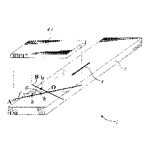
FIG. 2 schematically shows a basic sensor arrangement system 1. In this case,
two line-type distance sensors 6 are arranged to make measurements along non-
parallel
lines A, B. The intersection point 0 of these lines may lie on the measured
object 5, as
shown in the figure, or elsewhere. The distance sensors 4, 6 can be of any
suitable type,
chosen according to the needs of the particular application. These sensors 4,
6 should be
capable of identifying the measured distances at known points along the
lengths of the
measured lines, which need not be straight. Any of a wide variety of sensors
may be
used, including single-point or multiple-point distance sensors.
The measured object 5 moves in a substantially longitudinal direction 8
relative to
the sensor assembly 4, 6. FIG. 2 does not explicitly show any details of a
mechanism
for causing the required motion because such details can vary substantially
according to
CA 02788753 2012-07-31
WO 2011/094860
PCT/CA2011/000153
- 8 -
the physical characteristics of the measured object 5. Various mechanisms can
be
suitable, and their detailed designs do not form part of the present
invention. However,
they should include a means for measuring the longitudinal motion of the
moving object.
Any accurate measuring means is acceptable; for example, an encoder type
motion sensor
(not illustrated). The
motion sensor readings are used to trigger simultaneous
measurements from the line sensors, at regular intervals A along the measured
object.
For purposes of discussion, two example measurement points labeled a and b are
selected from along the measured lines in FIG. 2. Point a lies within line A
of sensor 4,
and point b lies within line B of sensor 6. The two points lie parallel to the
motion
(direction 8) of the measured object, and thus traverse a generally common
path along the
measured object.
In practice, the motion of the measured object is not precisely in a
longitudinal
direction, and may also include transverse motion perpendicular to the
measured surface
("translation"). Such translational motion causes all readings along both line
sensors to
increase or decrease simultaneously. Additionally, there may be a pitching
motion,
causing readings around point a to increase and readings around point b to
decrease, or
vice-versa. Yet additionally, there may be a rolling motion, causing readings
around both
a and b to increase and readings at the opposite side of intersection point 0
to decrease,
or vice-versa.
As an example, consider the case of an object spanned by n measured points at
regular spacing A. Let u, be the heights of the measured points on the surface
of the
object along the longitudinal line containing points a and b. The index i lies
within the
range 1 i n,
starting at 1 when the leading edge of the measured object reaches
intersection point 0, and incrementing sequentially as the measured object
moves
longitudinally by successive distance increments A relative to the sensors.
Let y, be the
corresponding translation amount of the measured object at the times when it
moves past
intersection point 0 by successive incremental distances A. Further, let z, be
the
corresponding pitch, and r, the corresponding roll of the measured object. It
should be
remembered that the present invention operates independently of these relative
motion of
the translation, pitch and roll.
CA 02788753 2012-07-31
WO 2011/094860 PCT/CA2011/000153
- 9 -
The geometry in FIG. 2 creates an inversion of the measured surface data. An
increase in surface height causes a decrease in distance sensor reading. To
avoid possible
confusion, it is convenient to define "height" quantities of the kind:
a, = H - a*, (1)
where a*, is the measured distance of the surface from sensor "a", H is a
"reference"
distance. The exact value chosen for H is not critical. For example, the
average value of
a*, would be a reasonable choice. However, the values of H chosen for the
other sensors
cannot be chosen with similar freedom. They should be such that all measured
"heights"
would be equal for the case of a flat object moving parallel to the sensor
array.
The readings measured at points a and b combine the contributions of local
surface heights, translation, pitch and roll as follows
a, =u,
+ y, + fz, + h r, (2)
b, = u,_q
+ y, + g z, + hr, (3)
where h is the transverse distance of points a and b from the intersection
point of the line
sensors, f and g are the corresponding longitudinal distances of a and b from
the
intersection point. For these distances, h is defined as being positive on the
side of the
measured object containing the example points a and b in FIG. 2. Distances f
and g are
defined as positive when upstream of intersection point 0. Thus, in FIG. 2,
distancefis a
positive quantity and distance g is a negative quantity.
In FIG. 2, the surface height measured at point a lies a distance f upstream
of
intersection point 0. This distance comprises approximately p steps of length
A, where p
is the nearest integer solution of p = f/ A. Thus, measurement a, indicates
surface height
in addition to the translation, pitch and roll motions. Conversely, the
surface height
measured at point b lies a distance g upstream of intersection point 0 (a
negative quantity
in FIG. 2). This distance comprises approximately q steps of length A, where q
is the
nearest integer solution of g=gIA (also a negative quantity in FIG. 2). Thus,
measurement b, indicates surface height u,_q in addition to the translation,
pitch and roll
motions.
CA 02788753 2012-07-31
WO 2011/094860 PCT/CA2011/000153
- 10 -
At points i+p and i+q equations (2) and (3) become
ai+p = ui + Yi+p f Zi-l-p h ri+p (4)
b,+q = /Ai + yi+q + g zi+q + h ri q (5)
Subtracting equation (5) from equation (4) to eliminate the quantity ui gives
(a ¨ bi+n) = ( Yi-f-p Yi+ei) + (f z1+ g
zi+n) + h ¨ ri+q)
(6)
Equation (6) applies at all points in the range 1¨q i n¨p. This set of
equations can be written in matrix form as
G m = d (7)
where G is a matrix whose rows contain the coefficients from the right side of
equation
(6), d is a vector whose elements are the measured data from the left side of
equation (6),
and m is a vector containing the set of translation, pitch and roll quantities
to be
determined
m = [ yi Zj ri y2 Z2 r2
y3 z3 r3 . . . yn Zn rn]T (8)
The matrix G that is formed from the single pair of measurement points a and b
has fewer rows than columns, and so is under-determined. However, the matrix
can be
substantially augmented using many additional rows from all other available
pairs of
corresponding measurement points along the two measurement lines shown in FIG.
2.
The boundary conditions
3)/ = Yn = Zn/2 = 0 (9)
can be enforced by including them as additional rows in matrix G. Other
combinations of
boundary conditions that similarly constrain the solution are also acceptable.
When all the various equations (6) and boundary conditions are assembled into
matrix G, the resulting number of rows should greatly exceed the number of
columns,
thereby making the matrix over-determined. In this case, the resulting
equation (7) can be
CA 02788753 2012-07-31
WO 2011/094860 PCT/CA2011/000153
- 11 -
solved in a least-squares sense by pre-multiplying by GT
GT G m = GT d (10)
Equation (10) involves the solution of 3n unknown quantities in vector m, and
can
be evaluated rapidly using modern computers. The surface shape map can then be
determined by inverting equations (4) and (5) to give
ui = ( ai+p + bi+q ¨ f g zi+q ¨
h ri+p ¨ h ri+q) I 2
(11)
where the interpretations of quantities u, a and b are now generalized to
refer to the
surface height profile along the longitudinal line traversed by any one given
pair of
measurement points along measurement lines A and B in FIG. 2. Exceptionally,
for
I < I¨q
it ai+p ¨ yi+p ¨ f z,+p ¨ h
ri+p (12)
and for 1> n¨p
14, ¨ bi+q ¨ yi+q ¨ g zi_q ¨ h
ri_q (13)
The assembly of the set of all the surface height values along all available
longitudinal lines produces a surface shape map of the measured object,
similar in
character to a topographic map. The mathematical method described in equations
(1) to
(13) is designed to keep the required numerical processing to a moderate size
such that
the calculations can be done in "real time", i.e., within a time less than
required for the
data acquisition. This feature is achieved by arranging for the matrix
solution in equation
(10), which is the most time consuming part of the calculation, to involve
only
translation, pitch and roll quantities. Surface shape quantities are excluded
because they
are many times more numerous, particularly when the line sensors in FIG. 2
contain many
finely spaced measurement points. In the described calculation method, the
presence of
more measurement points within the line sensors enhances computational
accuracy by
increasing data averaging. There is a proportionate increase in the time taken
to
formulate matrix GTG, but the solution time of equation (10) remains
unchanged.
CA 02788753 2012-07-31
WO 2011/094860 PCT/CA2011/000153
- 12 -
An economy in computation time can sometimes be achieved if the relative
motion of the measured object is such that one or more of the quantities y, z
and r have
relatively small influence. This could occur, for example, when some details
of the
mechanism producing the relative motions happen to constrain the measured
object by
differing amounts for the different types of relative motion. In particular,
the pitch z can
be less influential because the coefficients f and g in equation 11 have
opposite signs, so
the associated terms tend to cancel. Thus, it can sometimes happen that a
satisfactory
result can be achieved while excluding one or more of the relative motion
quantities from
equations (2)-(13).
The presence of only a few measurement points within the measured lines, or
the
occurrence of limited measurement accuracy, impair the stability of the
calculation, and
introduce noise into the solution. The use of line sensors arranged along
parallel lines,
especially when evenly spaced, also impairs computational stability because it
impairs the
numerical conditioning of matrix G, often to the point of singularity. The use
of several
parallel line sensors unevenly spaced could be effective, but entirely even
spacing is
always undesirable.
The adverse effects of these characteristics can be reduced by using
"regularization", a mathematical process that introduces smoothing. Such
regularization
does not create any new data, and so attention to the number, quality and
geometrical
arrangement of the measurements is always the preferable first step.
Regularization is
then a useful tool to make further refinements.
Several regularization techniques are commonly used, among them truncation and
filtering. A convenient technique is Tikhonov regularization. The procedure
involves
modifying matrix GTG in equation (13) to penalize extreme values in the
solution. The
penalty can be applied to the norm of the solution, thereby creating a "small"
solution, or
to the norm of the numerical first or second derivatives of the solution,
respectively
creating "flat" or "smooth" solutions. A simple form of Tikhonov
regularization adds an
extra term to equation (13)
(GTG + p B) m = GT d
(14)
CA 02788753 2012-07-31
WO 2011/094860 PCT/CA2011/000153
- 13 -
where f3 is a weighting factor called the regularization parameter. Matrix B
is the
identity, first or second derivative operator, chosen according to whether a
"small", "flat"
or "smooth" model solution is desired. In general, a "smooth" model is a
reasonable
choice because it is the most responsive to measurement noise.
Mathematical methods exist for finding the optimal value of the regularization
parameter 13, for example, using the Morozov discrepancy principle. However,
in most
practical cases, it is sufficient to find a value of 13 by trial and error
that reduces noise
without distorting the solution through excessive smoothing.
The sensor arrangement in FIG. 2 can operate successfully with a wide range of
placements of the measured lines. The lines could intersect within or outside
the
measured object, and they could be symmetrically or unsymmetrically arranged.
Additional line sensors could be included, possibly sharing or not sharing a
common
intersection point. The data from such sensors enhance the stability of the
measurement
by contributing many further rows to matrix G in equation (7). The described
mathematical method applies to all these possibilities. In general, greater
mathematical
solution stability is achieved when the measurement lines are symmetrically
arranged and
intersect near the centerline of the measured object. In addition, solution
stability is
improved when the measurement lines are aligned diagonally such that the
sensor
assembly spans around 10% of the length of the measured object. In general,
the use of
parallel line sensors is undesirable because it impairs the numerical
conditioning of
matrix G, often to the point of singularity. The use of several parallel line
sensors
unevenly spaced could be effective, but entirely even spacing is always
undesirable.
FIG. 3 shows a system 10 that is a variation of the previous sensor
arrangement of
FIG. 2, and is designed additionally to measure the surface shape map of an
opposite
surface on the measured object 15 moving in direction 18. This can be done
using just a
single additional line sensor 17 because the translation, pitch and roll of
the measured
object determined from lines A and B of sensors 14 and 16, similarly influence
the
measurements made using line C of sensor 17. There is, however, a change of
sign
corresponding to the reversal of the measurement direction. A convenient, but
not
essential choice for the position of line C of sensor 17 is perpendicular to
the longitudinal
CA 02788753 2012-07-31
WO 2011/094860
PCT/CA2011/000153
- 14 -
direction 18, aligned with intersection point 0. This particular choice
eliminates the
influence of pitch, allowing equation (2) to simplify to
v, = c, ¨ y, ¨ h r, (14)
where v is a surface height on the second side and c is a typical reading from
within line C
of sensor 17.
The unsymmetrical arrangement of the line sensors in FIG. 3 provides
measurements with different levels of accuracy on the two sides. In general,
it may be
expected that the accuracy of evaluation of the surface shape map on the side
measured
by lines A and B of sensors 14 and 16 will be superior to that on the side
measured by
line C of sensor 17. This is because each point in the height map of the first
side derives
from the average of two sensor readings rather than one. In addition, line C
of sensor 17
does not add anything to the evaluation of the translation, pitch and roll of
the measured
object, it just uses the values determined from the opposite side.
The non-uniform accuracy provided by the sensor arrangement in FIG. 3 can be
adjusted by using the symmetrical arrangement and system 20 shown in FIG. 4.
Here, a
pair of line sensors 24, 26 and 27, 29 measures each side of the measured
object 25
moving in direction 28. In this case, the measurements from both sides of the
measured
object can contribute to the evaluation of the translation, pitch and roll.
The
measurements from the second pair of line sensors add yet more rows to matrix
G,
thereby enhancing solution stability. However, there is no change in the
number of
columns, and thus the least squares matrix GTG remains the same size. The
reversal in
the measurement direction for the second side causes all equations used for
this side to
have the signs reversed for all terms containing y, z and r.
The sensor arrangements shown in FIG. 2, FIG. 3 and FIG. 4 are particularly
suited to the measurement of fairly flat surfaces that are generally
perpendicular to the
measurement directions. Under these circumstances, small side-to-side motions
of the
measured object do not significantly influence the measurements, and need not
be
accounted for. However, for measured objects with large surface slopes, for
example, a
cylinder, side-to-side motion becomes influential and must be explicitly
considered.
CA 02788753 2012-07-31
WO 2011/094860 PCT/CA2011/000153
- 15 -
FIG. 5 shows an example sensor arrangement and system 30 suited to the
measurement of the surface shape of an object 35 with large surface slope, in
this case a
cylinder. Additional line sensors 44, 46 and 47, 49 are included in the
transverse plane to
account for surface shape features and displacements in this direction, along
with line
sensors 34, 36 and 37, 39. FIG. 6(a) shows a cross-sectional view containing a
typical
measurement point a within one of the line sensors 34, 36 that make
measurements in the
vertical direction. Point 0 lies at the geometric center of the sensor
arrangement, and
forms the origin of a cylindrical coordinate system (R,0) that defines the
surface shape of
the measured object. In this configuration, it is convenient, but not
essential to define the
reference distance H in equation (1) such that the reported height a would be
zero if the
measured surface were flat, horizontal and passing through point 0. With this
definition,
the position of the surface point measured by sensor a is distance a above
point 0, and
distance h to the right. The cylindrical coordinates of the surface point are
R = Vh2 + az = arctan ( h / a ) (15)
If the measured object were perfectly cylindrical and centered on 0, the
surface
slope angle llf at all possible measurement points a would equal the local
coordinate angle
0. However, in the general case, these two angles are unequal. This angle can
be
determined from the local slope of the surface height profile measured along
the line
sensor. To give the slope within the cross-sectional plane shown in FIG. 6(a),
the slope
indicated from the line sensor must be divided by sin fi, where fi is the
local inclination of
the line sensor relative to the longitudinal direction. For computational
stability, it is
desirable to use a filter that smoothes the surface height data when
determining the local
slope, otherwise measurement noise will adversely influence the required
numerical
differentiation.
The surface height measured at point a combines the influences of the surface
height of the measured object, u, its vertical translation, y, its vertical
pitch, z, its roll
around axis 0, r, its horizontal translation, x, and its horizontal pitch, w.
Equation (2)
expands to
CA 02788753 2012-07-31
WO 2011/094860 PCT/CA2011/000153
- 16-
tit
a, = u,_p + y, + fz, + sin ( ¨ 0)R r, + tan .X1 ftan
lif VI)
cos 1,rf
(16)
Analogous expansions of equations (3)-(6) can similarly be constructed.
The geometrical quantities u, a, f, h, R, 0 and vi shown in FIG. 6(a) all
refer to an
individual measurement point a within a given measurement line. It is
convenient to
associate the definition of these quantities with the particular line sensor
rather than the
entire sensor assembly. This choice allows the associated equation (16) and
subsequent
equations to have a generally similar format for all sensor measurements,
independent of
orientation in space. For example, FIG. 6(b) shows the geometrical definitions
associated
with a measurement point a within a line sensor 47, 49 that makes measurements
in a
horizontal direction. The associated version of equation (16) is:
Off
a, = u,_p + x, + f sin-0) + _______________________ R r,
¨ tan tif y, ¨ ftan z,
cos if
(17)
where it can be seen that the overall equation format is preserved. The 90-
degree
difference in line sensor orientation causes quantities y and z to be
interchanged with x
and w, with sign changes where needed. These latter quantities are defined
relative to the
entire sensor assembly, and not just to individual sensors. Similar equations
apply to the
measurements from the other line sensors shown in FIG. 5. For non-
perpendicular line
sensor orientations, for example, a triangular sensor array, equations (16)
and (17) need to
be written in terms of vector components of the displacement quantities.
The equations analogous to equation (6) that derive from equations (16) and
(17)
can be assembled to form a matrix G with 5n columns and numerous rows. The
displacement quantities obtained by solving equation (14) can then be
subtracted from the
raw measurements, analogous to the use of equations (11) ¨ (13), to give the
true surface
shape map of the measured object.
CA 02788753 2012-07-31
WO 2011/094860 PCT/CA2011/000153
- 17 -
The formulation of equations (16) and (17) is based on the assumption that the
displacement quantities are small compared with the measurement spacing within
the line
sensors. When displacement quantities are relatively large, point b in FIG. 2,
and
analogously in subsequent figures, no longer shares the longitudinal path of
point a.
Instead, a point within the line sensor nearby to b shares that path. The
discrepancy
becomes a concern when large surface slopes yi are present. The issue can be
handled by
doing a first calculation assuming that all points a and b share their
longitudinal paths,
i.e., as described above. Then the points b can be chosen to be at the line
sensor locations
that give shared longitudinal paths after accounting for the motions of the
measured
object. The calculation can be repeated until convergence is obtained.
Typically, very
few iterations are required.
It is apparent that the ideas that constitute this invention can be applied to
meet a
wide range of measurement needs. The present disclosure describes the basic
principles
of the invention, and gives many practical details. Many possible variants of
the example
sensor arrangements can give successful results. They may have fewer or more
than two
line sensors per measured surface, these line sensors may or may not all be
intersecting,
they may have parallel or fan beams, line sensors need not be straight lines,
nor need they
be continuous, i.e., to allow space for an intersecting line sensor. It is not
even essential
that the measurements be made specifically along lines, only that pairs of
corresponding
measured points a and b can be identified. It is evident that a person skilled
in the art
could use the principles disclosed here to construct a surface shape map
measurement
system that varies in some details from the particular examples described
herein. It is
also evident that such a person could also employ mathematical methods
different from
the examples presented here to achieve the same or similar numerical results.
All such
variations lie within the scope of this invention.