Note: Descriptions are shown in the official language in which they were submitted.
CA 02796986 2012-10-18
WO 2011/141629 PCT/F12011/050421
1
Method and apparatus for mining vehicle safety arrangements
Field of the invention
[0001] The present invention relates to safety arrangements for min-
ing vehicles.
Background of the invention
[0002] Various mining vehicles, such as rock drilling equipment,
loading equipment and transport equipment, are used in a mine. Mining vehi-
cles may be manned or unmanned. Unmanned mining vehicles may be re-
mote-controlled from a control room, for instance, and they may be equipped
with measuring instruments suitable for location determination. Unmanned
mining vehicles may be driven automatically along a desired route in the mine,
as long as the location of the device can be determined. The location of the
device may be determined by using laser scanners, for instance.
[0003] Mining tunnels are usually narrow, and there is a risk that a
mining vehicle hits a mine wall or obstacles along the route while travelling
the
route. It is known to equip an unmanned mining vehicle with a scanner and to
monitor an area of a predetermined size in front of the mining vehicle.
W02004/086084 Al discloses an apparatus in which at least one lateral safety
zone is predetermined around a mining vehicle. In case an obstacle is detect-
ed on the basis of scanning in the safety zone determined for the mining vehi-
cle, an alarm is given and the mining vehicle stops automatically.
Brief description of the invention
[0004] There is now provided an improved solution for safety ar-
rangements of mining vehicles. The solution is characterised by what is stated
in the independent claims. Some preferred embodiments of the invention are
disclosed in the dependent claims.
[0005] According to an aspect of the invention there is provided a
method, in which obstacle information comprising at least location information
of predetermined obstacles is stored for controlling the safety system.
Location
information of an obstacle detected in the safety zone of the mining vehicle
on
the basis of scanning is compared with the location information determined in
the obstacle information. Stopping of the mining vehicle, caused by the safety
system due to a detected obstacle, is prevented in response to the detected
obstacle being determined safe in the obstacle information.
CA 02796986 2012-10-18
WO 2011/141629 PCT/F12011/050421
2
[0006] According to another aspect of the invention, there is provid-
ed an apparatus that is arranged to compare location information of an obsta-
cle detected in the safety zone of the mining vehicle on the basis of scanning
with location information of obstacles determined in the predetermined obsta-
cle information and to prevent stopping of the mining vehicle caused by the
safety system due to the detected obstacle in response to said detected obsta-
cle being determined safe in the obstacle information.
[0007] According to an aspect of the invention, there is provided a
method, in which location information of an obstacle detected in the safety
zone of the mining vehicle is determined in obstacle information to be part of
a
set of obstacles determined as safe in response to said obstacle being detect-
ed as safe. According to yet another aspect of the invention, there is
provided
an apparatus, which is arranged to determine location information of an obsta-
cle detected in the safety zone of the mining vehicle in obstacle information
to
be part of a set of obstacles determined as safe in response to said obstacle
being detected as safe.
[0008] According to an embodiment of the invention, a distance be-
tween the mining vehicle and an obstacle detected on the basis of scanning is
determined, the distance is compared with a predetermined minimum distance,
and location information of the obstacle is determined in response to the dis-
tance being shorter than the minimum distance.
[0009] The present invention provides several advantages, which
will become apparent from the detailed description. Now it is possible to de-
termine in driving route information obstacles that are detected as safe and
will
not induce a safety process leading to stoppage of the mining vehicle during
automatic driving. Typically, the mining vehicle is driven back and forth
along a
once taught route, for instance, between a loading station and an unloading
station, and now it is possible to avoid recurrent, unnecessary stops in situa-
tions where an obstacle is close to the mining vehicle, yet in such a manner
that the mining vehicle can be steered past the obstacle.
Brief description of the figures
[0010] Some embodiments of the invention will now be described in
greater detail by means of some preferred embodiments, with reference to the
attached drawings, in which
Figure 1 is a schematic side view of a mining vehicle,
CA 02796986 2012-10-18
WO 2011/141629 PCT/F12011/050421
3
Figure 2 is a top view of an arrangement for positioning and control-
ling a mining vehicle according to an embodiment,
Figures 3a and 3b illustrate apparatuses according to some embod-
iments for determining driving routes of a mining vehicle; and
Figures 4 to 6 show methods according to some embodiments.
[0011] In the figures, features associated with the invention are
shown in a simplified manner for the sake of clarity.
Detailed description of an embodiment of the invention
[0012] The solution of the invention is suitable for use in safety sys-
tems particularly related to mobile mining machines necessary for mining, such
as various mobile rock drilling rigs, loading and transport machinery. This
type
of mobile mining equipment is referred to as mining vehicles in the following.
The scope of application of the invention is not restricted to the safety
system
of a mining vehicle to be illustrated below, but the features of the invention
may
also be applied to other types of safety systems for mining vehicles. It is
also to
be noted that a mining vehicle may generally refer to various rock excavation
machines employed in a surface or underground operation area, i.e. the mining
automation system may also be located at least partly somewhere else than in
actual underground mines.
[0013] Figure 1 shows an example of a mining vehicle 1, in this
case loading equipment with a bucket 15 in front for transporting and loading
excavated material. The mining vehicle 1 may alternatively be rock drilling
equipment or transport equipment with a box, for example. The mining vehicle
1 comprises a movable carrier 2 with several wheels 3, of which at least one
is
a drive wheel that is driven by a motor 4 through transmission. The motor 4
may be an electric motor, combustion engine, hydraulic motor or any other de-
vice for providing rotation torque. Transmission usually comprises a gearbox 5
and required cardan shafts 6, differential gear and other power transmission
members for transmitting the rotation torque from the motor 4 to the drive
wheels. Unlike in the example of Figure 1, the mining vehicle may
alternatively
be track-driven. The mining vehicle 1 is also equipped with a control system
that includes at least a first control system 7 that is arranged to control
actua-
tors in the mining device 1 for controlling and driving the machine.
[0014] Further, the mining vehicle 1 may have a data transfer unit 8,
with which the first control unit 7 may establish a data transmission
connection
to a second control system 10 external to the mining vehicle 1 by utilising a
CA 02796986 2012-10-18
WO 2011/141629 PCT/F12011/050421
4
wireless connection provided by a base station 9. The second control system
may reside in a control room 11 that may be arranged outside the mine.
The control systems 7 and 10 may be computers equipped with appropriate
software.
[0015] Figure 1 is a simplified figure, and the control system of a
mining vehicle 1 typically comprises several units for implementing different
control functions. The control system of the mining vehicle 1 may be a distrib-
uted entity consisting of modules connected to a CAN (Controller Area Net-
work) bus, for example, and managing all measurements and controls of the
machine. The information system of the control room 11 may also comprise
one or more servers, databases, operator workstations and a connection to
other networks and systems.
[0016] The control system of the mining vehicle 1 comprises a posi-
tioning system or unit. According to an embodiment, the positioning system
comprises at least one gyroscope 12 that may be used to accurately determine
the direction of the mining vehicle for positioning. The positioning system
fur-
ther comprises means for determining the distance the mining vehicle 1 has
travelled. For instance, one or more sensors 13 may measure the rotation of a
wheel 3. On the basis of the measurement data, the positioning system deter-
mines the rotational motion of the wheel and then calculates the distance the
mining vehicle 1 has travelled. The positioning system may further comprise
one or more scanners 14, such as a laser scanner or the like capable of de-
termining the space and shapes surrounding the mining vehicle 1.
[0017] Figure 2 shows in accordance with an embodiment the prin-
ciple of route determination and use of applied in positioning and based on
scanning. A driving route 21 of the mining vehicle 1 may be created by teach-
ing. In that case the mining vehicle 1 is driven in manual control along a de-
sired route and on the basis of location data obtained by processing scanning
data, route points 22a, 22b for the route 21 are determined and stored in
memory at predetermined intervals. When the desired route 21 has been
taught and stored in the memory of the control system, the mining vehicle 1
may be controlled to drive the route 21 autonomously. The location of the min-
ing vehicle 1 may be determined during automatic control by using laser scan-
ners 14, for instance. On the basis of the scanning data and a pre-stored envi-
ronment model it is possible to determine the current location of the mining
vehicle 1, and no separate identifiers, such as reflectors or radio-frequency
CA 02796986 2012-10-18
WO 2011/141629 PCT/F12011/050421
identifiers, are needed on tunnel walls. The control system controls the
travel
of the mining vehicle on the basis of the determined location and the route
point data of the driving route in such a manner that the mining vehicle 1 re-
mains on the route 21.
[0018] The control system 7 of the mining vehicle 1 comprises a
safety system, the purpose of which is to monitor that the vehicle does not
col-
lide with external obstacles. The system may utilize data received from one or
more scanners 14 on the environment of the vehicle 1. According to an em-
bodiment, at least one scanner 14 or a separate distance measuring device
determines distances between the mining vehicle 1 and detected obstacles
during driving. An obstacle refers here to any object, such as tunnel wall or
loose rock, that may be relevant to the propagation of the mining vehicle 1.
[0019] For the mining vehicle 1 it is possible to determine at least
one safety zone 23 for collision monitoring performed by the safety system.
The safety zone illustrated in Figure 2 is determined in the lateral direction
C of
the mining vehicle 1 and in its both directions of travel A, B. It should be
noted,
however, that the safety zone need not be determined in all these directions,
but collision monitoring may be arranged, for instance, based only on data
produced by one scanner directed in the direction of travel of the mining vehi-
cle 1. The size of the safety zones in the direction of travel may vary in
differ-
ent directions A, B of the mining vehicle 1. The size of the safety zone may
further be different in the lateral direction C than in the directions of
travel A
and B. The safety zone 23 may determine one or more minimum distances
that shall remain between the mining vehicle 1 and the obstacle for safe prop-
agation of the mining vehicle 1. It is also to be noted that, naturally, the
safety
zone formed by the minimum distances need not be rectangular in shape.
[0020] There may be several safety zones 23 and compared mini-
mum distances. Safety monitoring may also include determination of (inner)
edge distance that is defined in relation to the mining vehicle 1 and may de-
pend on the specific dimensions of the mining vehicle 1, i.e., in practice, it
de-
pends on the external forms and structure of each particular machine 1. The
use of edge distances may prevent false alarms caused by movements of the
machine's 1 own structures, such as boom, bucket etc. The minimum distanc-
es, in turn, determine the locations of the outer edges of the safety zone 23.
In
dimensioning the minimum distances it is possible to consider, inter alia, di-
mensions of the mine tunnels, measurements and structure of the machine 1,
CA 02796986 2012-10-18
WO 2011/141629 PCT/F12011/050421
6
driving speed, conditions and further security-related details. According to
an
embodiment, the minimum distances may vary from one driving route to an-
other and/or in different sections of a driving route.
[0021] The control system of the mining vehicle 1 implements an al-
gorithm performing collision monitoring. In case the control system detects
that
there is an external obstacle 24 in at least one of the safety zones 23 of the
mining vehicle, the system gives a collision warning. The collision warning re-
fers generally to a collision risk indication provided by the safety system.
How-
ever, the collision warning may also refer to an impulse to carry out an (addi-
tional) safety check. On the basis of the collision warning, the mining
vehicle 1
may at least in some cases be stopped immediately, and further, the control
room 11 may be notified. Detection of an obstacle 24 appearing in the safety
zone may be verified by a plurality of detections before a collision warning
message is produced. Thus, it is possible to avoid false collision warnings.
[0022] Figure 3a illustrates an apparatus of an embodiment for de-
termining driving routes for a mining vehicle, for instance, for the mining
vehi-
cle 1 illustrated in Figure 1. The apparatus comprises at least a unit 30 for
de-
termining driving routes and/or for associating data with the driving route,
the
unit being referred to below as a route determination unit. The route
determina-
tion unit 30 is connected to a memory 31, in which various data used in the
determination of a route, such as an environment model, driving route, specif-
ics of the mining vehicle, and other data and parameters affecting route deter-
mination, may be stored. The route determination unit comprises a user inter-
face for a display 32 and at least one user interface for at least one input
means 33, such as a keyboard and/or mouse. The apparatus may also have
one or more other interfaces to other systems. The apparatus typically com-
prises at least one data transmission unit that may utilise standard TCP/IP-
based (Transport Control Protocol / Internet Protocol) network protocols, for
instance.
[0023] The route determination unit 30 may be operationally con-
nectable to a positioning system 34 that defines the location of the mining ve-
hicle 1 during its drive. The positioning system 34 may be part of the mining
vehicle 1, for instance, of the control system 7, and optionally, in part,
also part
of a navigation system implemented by the control system 10 outside the min-
ing vehicle 1.
CA 02796986 2012-10-18
WO 2011/141629 PCT/F12011/050421
7
[0024] The route determination unit 30 may be implemented on an
operator workstation, for instance. However, the route determination unit 30
need not be part of the data processing equipment used in controlling mining
operation or even connectable thereto, which means that route determination
is not fixed to a location or specific equipment. However, it should be noted
that it is possible to implement at least some of the present technical
features
associated with determination of route-related information, such as the route
determination unit 30, in the mining vehicle 1 and its data processing equip-
ment. According to an embodiment, the route determination unit 30 is specifi-
cally arranged to determine supplementary control information on the basis of
obstacles detected on the route in a manner illustrated in connection with Fig-
ure 5. Obstacle information may be stored in the memory 31 and/or transmitted
to other units, such as the control system 7 of the mining vehicle 1, so as to
control the safety system.
[0025] Figure 3b illustrates operational units for the mining vehicle,
for instance, for the control system 7 of the mining vehicle 1 in Figure 1. A
po-
sitioning system 35 takes care of determining the current location of the
mining
vehicle on the basis of the profile data received from the scanners 14 and the
predetermined environment model, for instance. On the basis of the location
information provided by the positioning system 35 and the driving route infor-
mation stored in advance and/or received during driving, a control unit 38 con-
trols the mining vehicle to drive along the determined route.
[0026] A safety unit 36 is connected to the positioning system 35,
the memory 37 and the control unit 38. The safety unit 36 implements at least
some of the operations of the mining vehicle safety system. The safety unit 36
may implement the algorithm performing the collision monitoring, taking care
of
at least the safety operations illustrated in connection with Figure 4. The
safety
unit 36 may be arranged to determine distances to walls or other obstacles
determined by the positioning system 35. Alternatively, calculation of
distances
is performed in some other unit, such as the positioning system, and the
safety
unit 36 receives information on an obstacle detected in the safety zone. The
safety unit 36 may be arranged to also implement other safety operations, for
instance, to stop the mining vehicle, when detecting that a person has entered
the limited operating area via a passage gate.
[0027] The units 30, 36 shown in Figures 3a and 3b may be imple-
mented, for instance, with one or more general-purpose processors of data
CA 02796986 2012-10-18
WO 2011/141629 PCT/F12011/050421
8
processing equipment, in which one or more computer programs are executed.
A computer program for controlling the processor implementing the operations
of the unit 30 may comprise code for implementing at least some of the fea-
tures related to the determination of obstacle information illustrated in
Figure 5.
A computer program for controlling the processor implementing the operations
of the unit 36 comprises code for implementing at least some of the features
related to the utilisation of predetermined obstacle information illustrated
below
in connection with Figure 4. The computer program may be stored on a ma-
chine-readable storage medium, such as the memory 31, 37 or a separate
memory means, from which the computer program may be retrieved for execu-
tion on the processor.
[0028] A software application implementing the route determination
unit 30 may be stored in a portable computer, for instance, from which route
data including obstacle information may be transferred via a telecommunica-
tions connection or a memory means to the control unit 10 of the control room,
for instance. The obstacle information may be further transferred from the con-
trol system of the control room to be used by the safety unit 36.
Alternatively,
the obstacle information may be transferred directly to the memory 37 utilised
by the safety unit 36 of the mining vehicle 1.
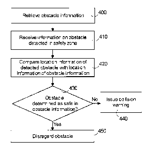
[0029] Figure 4 shows a method according to an embodiment,
which may be performed in the safety unit 36 illustrated in Figure 3b, for in-
stance. In the system, for instance, the memory 37, there is stored obstacle
information that may comprise at least location information on obstacles de-
termined as safe.
[0030] In the example of Figure 4, the prestored obstacle infor-
mation for controlling the safety system is retrieved or received in step 400,
for
instance, when the mining vehicle 1 starts driving autonomously on a prede-
termined driving route. The obstacle information may be read in advance in a
RAM, so that the information need not be retrieved during driving from the
file(s). It should be noted that, alternatively, the obstacle information
could be
retrieved from the memory or received during driving while performing safety
monitoring, for instance, only when an obstacle has been detected.
[0031] In the system implementing the method of Figure 4, such as
the control system 7 of the mining vehicle 1, the surroundings of the mining
vehicle 1 are scanned while driving the vehicle. In this context, scanning
should be understood broadly to cover determination and/or reception of any
CA 02796986 2012-10-18
WO 2011/141629 PCT/F12011/050421
9
type of information describing the current surroundings of a mining vehicle to
determine distances, in particular. When an obstacle is detected in the safety
zone 23 of the mining vehicle 1 on the basis of analysing scanning data, the
algorithm illustrated in Figure 4 receives an indication of this 410. In steps
420,
430, the location information of the detected obstacle is compared with the lo-
cation information determined in the obstacle information.
[0032] A correspondence analysis between the detected obstacle
and the obstacles determined in the obstacle information may be arranged in
various ways on the basis of the location information. The location
information
may be compared in steps 420, 430, for instance, such that a distance r of the
detected obstacle and a known obstacle determined in the location information
is calculated on the basis of the location information. In case r is smaller
than a
predetermined threshold value for a known obstacle, such as 0.5 m, the de-
tected obstacle is determined to correspond to said known obstacle. If the lo-
cation information of the now detected obstacle is not stored in the obstacle
information, a collision warning may be given in step 440 and/or additional
con-
trol operations may be performed on the basis of the collision warning (in an
embodiment, the algorithm of Figure 4 may receive a collision warning already
in step 410). The safety unit 36 may give a stop command to the control unit
38, which controls the mining vehicle 1 to stop. If the obstacle is determined
safe in the obstacle information, the obstacle is disregarded. In this case,
stop-
ping of the mining vehicle in step 450, caused by the safety system due to an
obstacle detected in the safety zone 23, e.g. one or more obstacles that are
closer than the minimum distance, may be prevented in response to the loca-
tion of said obstacle being sufficiently close to the location of an obstacle
de-
termined as safe.
[0033] Figure 5 shows a method for determining control information
for a mining vehicle according to an embodiment, which may be performed in
the route determination unit 30 illustrated in Figure 3a, for instance.
[0034] The method illustrated in Figure 5 may be applied while driv-
ing the mining vehicle 1 during determination and/or testing of a driving
route.
While driving the mining vehicle, the surroundings of the mining vehicle are
scanned and it is determined whether the distance between the mining vehicle
and the obstacle detected on the basis of scanning is smaller than the mini-
mum distance.
CA 02796986 2012-10-18
WO 2011/141629 PCT/F12011/050421
[0035] When an obstacle is detected in the safety zone 23 of the
mining vehicle 1, the algorithm illustrated in Figure 5 receives an indication
of
this in step 500. In step 510, information on the detected obstacle is
presented
to the user and the process waits for a user input. In the case of an unmanned
mining vehicle, for example, the obstacle may be shown to the user on a map
formed on the basis of information on the mine surroundings or, for instance,
as a picture on the display taken from the mining vehicle 1.
[0036] In step 530, the algorithm checks the input received from the
user in step 520. If the obstacle is selected as safe on the basis of the user
input, the obstacle is determined safe in the obstacle information. In step
550
the location information of the obstacle may then be stored with a selected ac-
curacy in the obstacle information as part of the set of obstacles determined
as
safe. On the other hand, if the user has not selected the obstacle as safe or
given an input, the obstacle may be disregarded in step 540 and the obstacle
information is not stored as part of the set of obstacles determined as safe.
[0037] It should be understood that the embodiments shown above
in connection with Figures 3a to 5 are only some examples of different ways to
implement the present functionality. Some other and further embodiments are
described below.
[0038] According to an embodiment, the location information of the
obstacle is only determined if the obstacle is detected to reside within the
safe-
ty zone. Figure 6 shows a method of an embodiment, which may be used in
connection with the methods illustrated in Figures 4 and 5. The distance of an
obstacle detected, for instance, on the basis of scanning to the mining
vehicle
1 is determined in step 600, and the determined distance is compared with at
least one minimum distance in steps 610, 620. If the minimum distance is ex-
ceeded, the obstacle is outside the safety zone 23 and the method may return
to estimate the next obstacle in step 600 (e.g. on the basis of the distance
de-
termined at regular intervals).
[0039] If the distance is smaller than the minimum distance, the ob-
stacle is inside the safety zone 23, and the location information of the
obstacle
is determined in step 630. The location information may be determined, for
instance, on the basis of the location of the mining vehicle at the moment of
detection and the direction of the scanning beam. After step 630 or in connec-
tion therewith, the process may advance to step 410 of Figure 4 or to step 500
of Figure 5 or input the information on the detected obstacle and its location
to
CA 02796986 2012-10-18
WO 2011/141629 PCT/F12011/050421
11
a unit executing the process of Figure 4 or 5. With this embodiment it is
possi-
ble to reduce the amount of processing during driving. Estimation of obstacles
is a naturally on-going process during the drive of the mining vehicle 1,
where-
fore it is also possible to return to step 600 after step 630. It is possible
to se-
lect that scanner measurements are performed, for instance, 5 to 20 times per
second in the area.
[0040] According to an alternative embodiment, location information
of obstacles is determined during driving and may be compared with the loca-
tion information of the obstacles determined in the obstacle information.
[0041] The location information of obstacles may define the x and y
coordinates of the points in a certain standard coordinate system. According
to
an embodiment, a third dimension is also used, meaning that also the coordi-
nate z may be defined.
[0042] According to an embodiment, the safety of an obstacle is de-
termined instead of (or in addition to) a user selection at least partly
automati-
cally. For example, after step 500 a specific estimation algorithm is
activated,
which determines more accurate information on the detected obstacle and de-
fines on the basis of additional checks whether the obstacle can be determined
to be part of the set of obstacles detected as safe. Estimation may utilize in-
formation on the specifics of the mining vehicle, such as the reach range. The
result of this estimation process may be presented to the user, who may
finally
confirm whether or not the obstacle is determined safe.
[0043] Obstacle information may be stored in connection with de-
termination or testing of a route, for instance. A safety check for an
obstacle
may be performed, for instance, when the determined driving route is tested
and in response to stopping of the mining vehicle caused by the safety system.
Thus, functions illustrated in connection with Figure 5 may be implemented by
a testing unit that is possibly at least operationally separate from the route
de-
termination unit 30. By using the testing unit, taught driving routes may be
tested on the basis of a test drive. The testing unit may comprise presently
dis-
closed features for marking the obstacles. According to another embodiment,
the route determination unit 30 provides a route determination tool, by which
obstacles may be added and removed. The route determination unit 30 and
the testing unit may be different tools of the same software or separate func-
tionalities implemented by a single physical apparatus, for example.
CA 02796986 2012-10-18
WO 2011/141629 PCT/F12011/050421
12
[0044] According to an embodiment, a driving route may be tested
in a computer-based manner by utilising simulation. A computer program im-
plementing the test application may retrieve or determine the simulation model
for the mining vehicle and the information on the driving route to be tested,
i.e.
the information on the route points of the driving route. The test application
may be implemented by the route determination unit 30 as part of the route
determination tool, for instance. The test application may run the computer
model describing the mining vehicle on the route to be tested. Movement of the
mining vehicle may be illustrated to the user on a mine map formed on the ba-
sis of the environment model or in other type of model describing the produc-
tion area. The test application may also implement steps illustrated in connec-
tion with Figure 5 for the obstacles detected on the basis of the simulation.
The
user may detect what kind of space remains around the vehicle in each part of
the route. Alternatively, the program calculates the space remaining between
the vehicle and the wall on the route and notifies the user of any points
where
the distance is smaller than the minimum distance. With this embodiment, time
required for testing the route can be shortened, or the testing of the route
may
even be completely avoided by driving the mining vehicle 1. This kind of com-
puter-based route testing may be used, for instance, when a return route for
the already determined driving route is tested, and, in this case, the mining
vehicle need no longer necessarily be separately driven in order to test the
return route determined on the basis of the information on the driving route.
[0045] Obstacle information may be determined and stored in vari-
ous ways, of which some examples are shown below. The obstacle information
may include information on obstacles detected as safe and/or unsafe. For ex-
ample, the obstacle information may comprise information on obstacles deter-
mined as unsafe, and, unlike in Figure 4, a detected obstacle may be deter-
mined safe on the basis of checking this obstacle information. According to an
embodiment, a list of obstacles separately determined as safe is stored,
whereby it is possible to typically keep the amount of data to be compared dur-
ing driving small. According to another embodiment, it is indicated in the ob-
stacle information, for instance in a certain field, that the obstacle is
deter-
mined safe.
[0046] According to an embodiment, the driving route may be de-
fined by a plurality of independent segments, each comprising several route
points. The information on the route points determined for the driving route
CA 02796986 2012-10-18
WO 2011/141629 PCT/F12011/050421
13
may be stored as associated with a given identifier of the driving route
and/or a
segment. The segment-specific information may be pre-stored in the memory
of the control equipment of the mining vehicle 1, whereby the route determina-
tion takes place at its simplest by sending only a list of identification
codes of
the route segments associated with the assignment. Segment-based route de-
termination is described in more detail in publication W02004/085965, which is
incorporated herein by reference.
[0047] According to an embodiment, at least the location infor-
mation of obstacles detected as safe is determined as part of a data element
defining the entire driving route or a driving route segment, or in a file
separate
from the driving route file.
[0048] According to an embodiment, the obstacle information is also
determined from one segment to another. Obstacle information may be deter-
mined 550 for each route segment in the route segment information or in a
separate file. Thus, the safety unit 36 may compare 420 the information on the
detected obstacles only with the obstacle information associated with the
route
segment in question.
[0049] According to an embodiment, the obstacle information is
stored in an xml-based (extensible markup language) file, which may also
comprise the driving route information, such as route point elements for each
route point determined during the teaching of the driving route. However, it
is
to be noted that the obstacle information need not be stored in connection
with
the driving route information or in a file, but they may be entirely
independent
of the driving routes. Obstacle information may be stored in connection with
an
environment model describing the mine, for instance.
[0050] It will be obvious to a person skilled in the art that, as tech-
nology advances, the basic idea of the invention may be implemented in many
different ways. The invention and its embodiments are thus not restricted to
the
examples described above, but may vary within the scope of the claims. Thus,
different features may be left out, modified or replaced by equivalent
features,
and the features described in this patent application may be combined to form
various combinations.