Note: Descriptions are shown in the official language in which they were submitted.
CA 02798805 2012-12-13
CG200016
CONTROLLER AND METHOD FOR STEERING SOURCES
BACKGROUND
TECHNICAL FIELD
[0001] Embodiments of the subject matter disclosed herein generally
relate to methods and systems and, more particularly, to mechanisms and
techniques for steering sources while being towed in water by a vessel.
DISCUSSION OF THE BACKGROUND
[0002] Marine seismic data acquisition and processing generate a profile
(image) of a geophysical structure under the seafloor. While this profile does
not
provide an accurate location of oil and gas reservoirs, it suggests, to those
trained in the field, the presence or absence of these reservoirs. Thus,
providing
a high-resolution image of the geophysical structures under the seafloor is an
ongoing process.
[0003] Reflection seismology is a method of geophysical exploration to
determine the properties of earth's subsurface, which are especially helpful
in the
oil and gas industry. Marine reflection seismology is based on using a
controlled
source of energy that sends the energy into the earth. By measuring the time
it
takes for the reflections to come back to plural receivers, it is possible to
evaluate
the depth of features causing such reflections. These features may be
associated with subterranean hydrocarbon reservoirs.
[0004] A traditional system for generating the seismic waves and
recording
their reflections off the geological structures present in the subsurface is
illustrated in Figure 1. A vessel 10 tows an array of seismic receivers 11
provided on streamers 12. The streamers may be disposed horizontally, i.e.,
1
CA 02798805 2012-12-13
CG200016
lying at a constant depth relative to a surface 14 of the ocean. The streamers
may be disposed to have other than horizontal spatial arrangements. The vessel
also tows a seismic source array 16 that is configured to generate a seismic
wave 18. The seismic wave 18 propagates downwards toward the seafloor 20
and penetrates the seafloor until eventually a reflecting structure 22
(reflector)
reflects the seismic wave. The reflected seismic wave 24 propagates upwardly
until it is detected by the receiver 11 on the streamer 12. Based on the data
collected by the receiver 11, an image of the subsurface is generated by
further
analyses of the collected data.
[0005] The seismic source array 16 may include plural individual source
elements. The individual source elements may be grouped in sub-arrays, so that
each source array may include one or more sub-arrays. The individual source
elements may be distributed in various patterns, e.g., circular, linear, at
various
depths in the water. Figure 2 shows a vessel 40 towing two cables 42 provided
at respective ends with deflectors 44. Plural lead-in cables 46 are connected
to
streamers 50. The plural lead-in cables 46 also connect to the vessel 40. The
streamers 50 are maintained at desired separations from each other by
separation ropes 48. Plural individual source elements 52 are also connected
to
the vessel 40 and to the lead-in cables 46 via ropes 54. However, this
configuration does not allow an accurate control of the plural individual
source
elements. In other words, a position of the source array 16 cannot be adjusted
except by changing the position of the vessel 40.
[0006] Further, the presence of the deflectors 44 introduces a further
control problem as the deflectors rely on hydrodynamic forces, e.g., lift,
created
by the motion through the water to pull the streamers 50 outwardly to maintain
their separation relative to the vessel path during the survey. Thus, water
currents or other environmental factors may affect the lift, determining the
deflectors to move closer to each other. As such, the positions of the
streamers
2
CA 02798805 2012-12-13
CG200016
50 and the plural individual source elements 52 are also affected by the
positions
of the deflectors. In this instance, the navigation system of the vessel
modifies a
trajectory of the vessel for bringing the sources as close as possible to a
desired
position. However, it is undesirable to use the navigation system of the
vessel to
adjust the positions of the sources because a change in the position of the
vessel
also changes the positions of the streamers.
[0007] Further, as four-dimensional (4-D) geophysical imaging is becoming
more desired today, controlling the positions of the source array and of the
streamers is important. 4-D geophysical imaging involves 3-D seismic surveys
repeated over the same subsurface at different moments in time to determine
changes in the geophysical structures of the subsurface. Thus, as the 3-D
survey is repeated in time, sometimes after a few months or years, it is
desirable
that the sources and streamers being used to perform the seismic survey are
located as closely as possible to the same locations as in the previous survey
over the subsurface.
[0008] Thus, it is challenging with existing source steering technology
to
position both the source arrays and the streamers, at different moments in
time,
at the same locations given the cross-currents, wind, waves, shallow water and
navigation obstacles that are currently encountered by vessels that perform
the
seismic surveys.
[0009] Accordingly, it would be desirable to provide systems and methods
that provide a method for steering source arrays at a desired location during
towing underwater by a vessel without changing the position of the vessel.
SUMMARY
[0010] According to one exemplary embodiment, there is a method for
steering a seismic source array in a body of water during a seismic survey.
The
method includes measuring an actual position of the seismic source array;
3
CA 02798805 2012-12-13
CG200016
calculating a virtual position of the seismic source array, wherein the
virtual
position corresponds to a position of the seismic source array when towed with
no adjustment from a source steering device; retrieving a pre-plot path that
includes desired positions of the seismic source array for the seismic survey;
and
steering the vessel based on the virtual position so that the virtual position
lies on
the pre-plot path.
[0011] According to another exemplary embodiment, there is a seismic
surveying system configured to steer a seismic source array in a body of water
during a seismic survey. The system includes a central control unit configured
to,
receive an actual position of the seismic source array, and calculate a
virtual
position of the seismic source array, wherein the virtual position corresponds
to a
position of the seismic source array when towed with no adjustment from a
source steering device. The system also includes a memory configured to store
a pre-plot path that includes desired positions of the seismic source array
for the
seismic survey; and an integrated navigation system configured to steer a
vessel
that tows the source array based on the virtual position so that the virtual
position
lies on the pre-plot path.
[0012] According to yet another exemplary embodiment, there is a
computer readable medium including computer executable instructions, wherein
the instructions, when executed by a processor, implement a method for
steering
a seismic source array in a body of water during a seismic survey. The
instructions are configured to implement the method discussed above.
BRIEF DESCRIPTION OF THE DRAWINGS
[0013] The accompanying drawings, which are incorporated in and
constitute a part of the specification, illustrate one or more embodiments
and,
together with the description, explain these embodiments. In the drawings:
4
CA 02798805 2012-12-13
CG200016
[0014] Figure 1 is a schematic diagram of a conventional seismic survey
system;
[0015] Figure 2 illustrates a traditional arrangement of a source array
that
is towed by a vessel;
[0016] Figure 3 illustrates an arrangement of steerable source arrays and
plural streamers according to an exemplary embodiment;
[0017] Figure 4 is a schematic diagram of two source arrays having source
steering devices according to an exemplary embodiment;
[0018] Figure 5 is a schematic diagram of a source array having a source
steering device according to an exemplary embodiment;
[0019] Figure 6 is close view of a source steering device as attached to
a
sub-array according to an exemplary embodiment;
[0020] Figure 7 is an overview of a seismic survey system that corrects a
position of a source array with a source steering device according to an
exemplary embodiment;
[0021] Figures 8A-D illustrate a seismic survey system that corrects a
position of a source array with a source steering device and by changing a
path
of a towing vessel according to another exemplary embodiment;
[0022] Figure 9 is a schematic diagram of a control system of a seismic
survey system according to an exemplary embodiment;
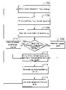
[0023] Figure 10 is a flowchart of a method for controlling a seismic
survey
system according to an exemplary embodiment;
[0024] Figure 11 is a schematic diagram of a controller according to an
exemplary embodiment; and
CA 02798805 2012-12-13
CG200016
[0025] Figure
12 is a flow chart of a method for steering a vessel according
to an exemplary embodiment.
DETAILED DESCRIPTION
[0026] The
following description of the exemplary embodiments refers to the
accompanying drawings. The same reference numbers in different drawings
identify the same or similar elements. The following detailed description does
not
limit the invention. Instead, the scope of the invention is defined by the
appended
claims. The following embodiments are discussed, for simplicity, with regard
to the
terminology and structure of a seismic source array being towed by a vessel
and
being connected to at least one source steering device.
However, the
embodiments to be discussed next are not limited to this source array, but may
be
applied to other seismic elements as, for example, streamers.
[0027]
Reference throughout the specification to "one embodiment" or "an
embodiment" means that a particular feature, structure or characteristic
described
in connection with an embodiment is included in at least one embodiment of the
subject matter disclosed. Thus,
the appearance of the phrases "in one
embodiment" or "in an embodiment" in various places throughout the
specification
is not necessarily referring to the same embodiment. Further, the particular
features, structures or characteristics may be combined in any suitable manner
in
one or more embodiments.
[0028]
Emerging technologies in marine seismic surveys need a steerable
seismic source array. According to an exemplary embodiment, such steerable
seismic source arrays are configured to include at least a source steering
device
that is capable to adjust a position of the source array while being towed by
a
vessel and without involving a change of the path of the vessel. In other
words, a
position of the source array may be changed during a seismic survey without
changing the cross-line position of the vessel that tows the source. To
achieve
6
CA 02798805 2012-12-13
CG200016
this goal, a controller of the source steering device cooperates with the
navigation system of the vessel so that some positional changes of the source
array are not taken into consideration by the vessel.
[0029] More specifically, according to an exemplary embodiment, there is
a method for steering a seismic source array in a body of water during a
seismic
survey. The method includes a step of measuring an actual position of the
seismic source array; a step of calculating a virtual position of the seismic
source
array; a step of retrieving a pre-plot path that includes desired positions of
the
seismic source array for the seismic survey; and a step of steering the vessel
based on the virtual position so that the virtual position lies on the pre-
plot path.
Further, the method adjusts the settings of a source steering device to change
the actual position of the source array. In one exemplary embodiment,
adjusting
the source steering device (e.g., a winch) is much faster than adjusting a
position
of the vessel. Thus, in this case, the actual position of the source array is
first
adjusted by the source steering device and then the vessel is instructed to
change its position to adjust the virtual position of the source array. These
adjustments of the source steering device and the position of the vessel may
continue for some time until the actual position and the virtual position
substantially coincide. It is noted that in one exemplary embodiment, by
adjusting the position of the vessel and thus, implicitly the virtual
position, the
actual position is disturbed and the source steering device needs to adjust
it.
The frequency of adjusting the actual position with the source steering device
may be a parameter that is chosen by the operator of the vessel.
[0030] In another exemplary embodiment, there is an interface between (i)
dedicated systems that steer the vessel and (ii) one or more source steering
devices as known in the art. In other words, an existing vessel having a known
steering system and also having a known source steering device may be
retrofitted with the novel interface for steering the vessel so that a virtual
position
7
CA 02798805 2012-12-13
CG200016
is used instead of an actual position of the source. The novel interface may
be
integrated, as discussed later, in a control system.
[0031] Prior to describing this method and the corresponding interface in
more details, a configuration of a seismic survey system is described with
reference to Figures 3 and 4. Based on the exemplary system shown in these
figures, it is then explained the method of controlling the source steering
device
and the source arrays. Thus, the embodiments shown in Figures 3 and 4 are not
intended to limit the applicability of the invention but only to provide a
simple
example for explaining the control method. Further, in the following, a
seismic
source array is considered to include, as individual source elements, an air
gun,
a water gun, a vibratory source, etc.
[0032] According to an exemplary embodiment illustrated in Figure 3, a
vessel 100 tows two source arrays 110a and 110b (it is also possible to tow
only
one source or more than two sources but, for simplicity, the novel features
are
discussed with regard to two source arrays) and plural streamers 120. The
streamers 120 are connected to the vessel through lead-ins 122 while the
source
arrays 110a and 110b are connected to the vessel 100 through cables 112.
Each source array 110a or 110b may include sub-arrays 114, each sub-array
having plural individual source elements 116. Deflectors 140 are provided on
the
sides of this arrangement to maintain a transverse distance (relative to the
path
of the vessel) between the streamers 120. The deflectors 140 are connected to
the vessel 100 via wide tow cables 142, and spread ropes 144 are used to
separate the streamers from each other.
[0033] It is noted that the terms "rope" and "cable" and "wire" are used
sometimes interchangeably in this document. Thus, these terms should not be
construed in a narrow sense but rather as those skilled in the art would
expect.
The number of streamers or source arrays is exemplary and not intended to
limit
the applicability of the novel concepts.
8
CA 02798805 2012-12-13
CG200016
[0034] Figure
4 shows in more detail the two source arrays 110a and 110b
and their source steering devices 200a and 201a. Figure 4 shows each source
array having three sub-arrays. Further, the figures show each sub-array 114a-c
and 115a-c of the source arrays 110a and 110b having their own source steering
devices (200a-c and 201a-c). However, the novel method to be discussed later
for steering the source arrays is also applicable if there is only one source
steering device per source array. If there is only one source steering device
per
source array, then a deflector 234 or similar element, as shown in Figure 5,
could
be attached to the sub-array 114c for maintaining the cables 230 and 232
stretched, for maintaining a desired distance between the sub-arrays. It is
noted
that the source steering devices discussed herein are exemplary in nature and
other locations or types for them may be used. For example, the source
steering
device may be a winch located on the vessel and connected with ropes or cables
to one or more sub-arrays for adjusting their positions along the Y-axis.
However, for simplicity, in the following, the source steering device is
considered
to be a winch located on a sub-array.
[0035]
Figures 4 and 5 also show ropes 220a and 220b connecting the
source steering devices 200a and 201a to lead-ins 122a and 122b, respectively.
The lead-ins 122a and 122b may or may not be connected to corresponding
streamers 120a and 120b. In this application, the positions of each source
array
110a or 110b are independently controlled from each other.
[0036] It is
noted that cable 220a (and 220b) may be either fixed to the
lead-in 122a or may be provided with a slider 222a that can move freely along
the cable 122a. The slider 222a may include, for example, a pulley. Thus, the
cable 220a may be maintained substantially perpendicular on the sub-array 114a
as the length of the cable 220a is adjusted by the source steering device
200a.
[0037] A
source steering device may be an actuator device 300 as show in
Figure 6, or a deflector, or a thruster, or a rudder or any device that may
change
9
CA 02798805 2012-12-13
CG200016
the position of the source array. The actuator device 300 may be a winch that
is
attached, for example, to a base plate 302. The base plate 302 is connected by
curved bolts 304 and screws 306 to a bell housing 320. The bell housing 320 is
a frontal part of the source array. Other methods for connecting the winch to
the
bell housing may be used. The bell housing 320 may be connected to the
connection (or umbilical) 322 of the source array via an intermediate piece
324.
For example, this intermediate piece 324 may be made of polyurethane and thus
has a bending property. In one application, the actuator device 300 may be
attached to a bend restrictor device instead of the bell housing 320.
[0038] To control the source steering devices for the above noted
configurations, it is possible to have a local control mechanism for each
source
steering device and/or a central control mechanism that interacts with the
local
control mechanisms. For example, as shown in Figure 4, the source steering
device 200a may have its own local control mechanism 260a that may be
programmed to maintain a certain position of the corresponding sub-array 114a.
In another application, the local control mechanism 260a communicates (wired
or
wireless) with a central control mechanism 262 situated on the towing vessel
100
in order to receive the position coordinates for the source array and/or sub-
arrays. Thus, the central control mechanism 262 may be configured to instruct
the local control mechanism 260a with regard to when and how long to activate
the source steering device. These relationships are now discussed in more
detail
with regard to Figure 7.
[0039] For simplicity, Figure 7 shows a seismic survey system 400 that
includes a towing vessel 402 that follows a predetermined travel path 404. The
vessel 402 tows two source arrays 406a and 406b, each including at least one
source steering device 408a and 408b, respectively. The sources 406a and
406b are directly connected to the vessel 402 through cables 409a and 409b.
The source steering devices 408a and 408b are connected to lead-ins 410a and
CA 02798805 2012-12-13
CG200016
410b through cables 412a and 412b. These cables may be connected to the
lead-ins, as discussed above, i.e., through corresponding sliders 414a and
414b.
[0040] A controller 420 provided on the vessel 402 is configured to
generate commands to be provided to the vessel 402 to change its position such
that source arrays 406a and 406b follow predetermined paths (source pre-plot
paths) 450. In this case, the controller 420 interacts with an integrated
navigation
system (not shown but to be discussed later) of the vessel for steering the
source
arrays 406a and 406b. It is noted that the vessel 402 does not adjust its
trajectory when a deviation of the source arrays 406a and 406b from the source
pre-plot path 450 are below a predetermined threshold.
[0041] For steering the vessel, the traditional methods use an actual
position 430 of the source array and compares it to a desired path or source
pre-
plot path 450. If a difference between the pre-plot path 450 and the actual
position 430 of the source array is determined to be larger than the
predetermined threshold, the vessel is steered to bring the actual position
430 of
the source array closer to the source pre-plot path 450.
[0042] However, in an exemplary embodiment, the actual position 430 of
the traditional method is not used to steer the vessel. According to this
exemplary embodiment, a virtual position 434 of the source array is introduced
as
discussed next and the virtual position 434 of the source array is fed to the
vessel. Thus, the vessel adjusts the virtual position 434 of the source array
relative to the source pre-plot path 450. The virtual position 434 is defined
as a
position of the source array when the source steering device is not present
or, if
the source steering device is present, as a position that the source array
will take
when the source steering device is not in use, i.e., it is in a neutral
position. The
neutral position may be defined based on the nominal configuration of the
survey,
e.g., for two sources separated by 25 m, symmetrical around a longitudinal
axis
of the vessel.
11
CA 02798805 2012-12-13
CG200016
[0043] An example is provided to illustrate this concept. Assuming that
the
source steering device 408a of the source array 406a is a winch, the winch has
a
neutral position in which its cable is neither extended nor retrieved. For
example,
as shown in Figure 7, the cable 412a has a length L for maintaining the source
array 406a at a desired position. This position is called the neutral position
of the
source steering device and it corresponds to the virtual position of the
source
array. When the cable 412a is neither extended nor retrieved, the actual
position
430 of the source array 406a coincides with the virtual position 434.
[0044] Thus, according to an exemplary embodiment, the vessel is steered
so that the virtual position 434 of the source array 406a is maintained along
the
source pre-plot path 450. Suppose that the actual position 430 of the source
array 406a deviates by a distance AL from the source pre-plot path 450 as
shown
in Figure 8A. This may happen, for example, due to ocean currents. Other
factors may determine this deviation. At this stage, the actual position 430
still
coincides with the virtual position 434. However, the actual position 430 of
the
source array needs to be corrected so that the seismic survey is accurate. In
a
first instance, the source steering device 408a extends the rope 412a from a
length L (as shown in Figure 8A) to a length L + AL (as shown in Figure 8B).
Thus, the actual position 430 of the source array is brought on the source pre-
plot path 450 in a short amount of time as activating the source steering
device is
much quicker than adjusting a position of the vessel 402. In one application,
the
distance AL is achieved in incremental steps, i.e., the actual position 430 of
the
source array is measured and the source steering device is adjusted with an
increment of AL and then these steps are repeated until the actual position
430
lies on the source pre-plot path 450.
[0045] However, the virtual position 434 of the source array 406a is as
shown in Figure 8B, i.e., corresponds to the length L of the rope 412a. As
noted
above, the virtual position 434 if provided to the vessel 402 as being the
actual
12
CA 02798805 2012-12-13
CG200016
position of the source array 406a. Based on this information, the vessel 402
starts to change its path to move in the positive direction of the Y-axis so
that the
virtual position 434 is gradually brought on the source pre-plot path 450.
[0046] As the vessel 402 moves with AY (it is noted that the distances
shown in the figures are not at scale) along the positive direction of the Y-
axis as
shown in Figure 8C, the actual position 430 of the source array 406a moves
with
AY away from the source pre-plot path 450 but the virtual position 434 is
closer to
the path 450. Thus, the source steering device 408a is now instructed to
retract
the rope 412a by an equal amount to reposition the source array (the actual
position 430) back on the source pre-plot path 450. This configuration is
illustrated in Figure 8D, in which the length of the rope 412a is now shorter,
i.e., L
+ AL ¨ AY, the actual position 430 lies on the source pre-plot path 450 and
the
virtual position 434 is closer to the pre-plot path 450. These adjustments
continue until the actual position 430 and the virtual position 434 coincide
again
as in Figure 8A.
[0047] Thus, the embodiment disclosed with regard to Figures 8A-D
achieves a quick adjustment of the actual position of the source array by
using
the source steering device and then the vessel adjusts its position to bring
the
virtual position of the source array back on the source pre-plot path. During
this
process, the source steering device adjusts the length of its rope to account
for
the movement of the vessel on a lateral direction so that the actual position
of the
source array is maintained on or close to the source pre-plot path 450 as the
virtual position 434 is adjusted by the vessel 402 to also be on or close to
the
source pre-plot path 450.
[0048] In this regard, it is noted that a position of the source array
406a
may be determined by a GPS system that has a component 440a on the source
array 406a and a component 440b on the vessel 402 as shown in Figure 7.
Alternatively, the position of the source array 406a may be determined using
at
13
CA 02798805 2012-12-13
CG200016
least one of an acoustic system, radio-navigation means, a laser system, a
radar
system, etc. Communication between the components 440a and 440b may be
achieved through wires that are part of the lead-ins 409a or 410a or attached
to
the lead-ins or through a wireless interface. The GPS and acoustic devices are
known in the field and thus, no description is provided for these devices. The
GPS and/or acoustic devices may be provided on a float (not shown) that
maintains the actual sources at a desired depth until water. The float is
configured to float at the surface of the water.
[0049] Thus, according to the above noted embodiment, the actual
position 430 of the source array is fed to the controller 420 for adjusting
the
lengths of the cable 412a by the source steering device 408a while the virtual
position 434 of the source array is used by the vessel for maintaining it
along the
source pre-plot path 450.
[0050] According to an exemplary embodiment illustrated in Figure 9, a
configuration of a control device 500 for controlling both the vessel 402 and
the
source steering device 408a may include the central controller 420, located,
for
example, on the vessel 402, and a local controller 510, located, for example,
on
the source array 406a. The two controllers communicate through a wired or
wireless interface 512. The central control unit 420 may be configured to
communicate through a link 514 with an integrated navigation system (INS) 520
of the vessel. The INS 520 controls the auto-pilot 522 of the vessel 402 and
the
local control unit 510 controls the source steering device SD1 530.
[0051] Controlling the position of the source array is now discussed with
regard to Figure 10. Based on the GPS and/or the acoustic data received from
components 440a and 440b, the central control unit 420 computes in step 1000
the actual position 430 of the source array. In step 1002, the central control
unit
420 receives the settings of the source steering device 408a and in step 1004
the
14
CA 02798805 2012-12-13
CG200016
central control unit 420 calculates the virtual position 434 of the source
array
406a.
[0052] In step 1006, the central control unit 420 determines whether the
virtual position 430 is away from the source pre-plot 450. If the answer is
NO,
the central control unit 420 instructs the INS 520 in step 1008 to maintain
the
path of the vessel unchanged and the same is transmitted by the INS 520 to the
auto-pilot 522. If the answer is YES, the central control unit 420 instructs
in step
1010 the vessel to change course so that the virtual position of the source
array
is brought back on the source pre-plot path 450. Irrespective of whether step
1008 or step 1011 is selected, the process advances to step 1012 in which the
source steering device settings are calculated, for example, by the central
control
unit 420, so that the actual position of the source array is on the source pre-
plot
path 450. These settings are sent in step 1014 to the source steering device
to
extend or retract in step 1016 its rope (if a winch is used) to adjust the
actual
position of the source array. Then, the process returns to step 1000 and the
previous steps are performed again to readjust the virtual position and/or the
actual position of the source array. The process continues until both the
actual
position 430 and the virtual position 434 are on the source pre-plot path 450
or
close enough to this path and/or the source heads in a right direction. In one
exemplary embodiment, the novel process addresses not only adjusting the
position (virtual and actual) of the source array but also obtaining the
correct
heading angle.
[0053] For the above method, the pre-plot information needs to be
available either in the INS 520 or the central control unit 420. Further, it
is noted
that a deflector is used instead of a winch, an attack angle of the deflector
is
modified to adjust the actual position of the source array. If a thruster is
used
instead of a winch, the thrust is modified to adjust the actual position of
the
source array. The same is true for other types of source steering devices.
CA 02798805 2012-12-13
CG200016
[0054] Based on the method described in Figure 10, the rough tuning of
the virtual position of the source array relative to the pre-plot position is
performed by the vessel and the fine tuning of the actual position relative to
the
pre-plot position is performed by the source steering device.
[0055] Thus, according to an exemplary embodiment, the INS 520 does
not use the actual position of the source array when adjusting the position of
the
vessel. The actual position of the source array is used to analyze the signals
recorded by the streamers. Thus, for this analysis, the virtual positions of
the
source arrays are not used.
[0056] If more than one source array is controlled based on the above
noted exemplary embodiments, it is possible to define pre-plot paths for each
source and to monitor the actual positions and the virtual positions of these
sources. Other variants of the above discussed embodiments may be envisioned
by those skilled in the art based on the novel feature of using the virtual
position
for steering the vessel and the actual position for steering the source
steering
device.
[0057] In one exemplary embodiment, the local control unit 510 may be
located on the vessel 402 instead of the source array. In another exemplary
embodiment, the central control unit 420 may be part of the INS 520 or may be
distributed at one or more of the source arrays. In still another exemplary
embodiment, the central control unit 420 and the local control unit 510 may be
implemented in the INS 520.
[0058] With regard to the local and/or central control units discussed
above, a possible configuration of such a device is schematically illustrated
in
Figure 11. Such a control unit 1100 may include a processor 1102 and a storage
device 1104 that communicate together via a bus 1106. An input/output
interface
1108 also communicates with the bus 1106 and allows an operator to
16
CA 02798805 2012-12-13
CG200016
communicate with the processor or the memory, for example, to input software
instructions for operating the source steering devices. The input/output
interface
1108 may also be used by the controller to communicate with other controllers
or
interfaces that are provided on the vessel. For example, the input/output
interface 1108 may communicate with a GPS system (not shown) for acquiring
the actual position of the source array or with an acoustical system for
acquiring
actual positions of the independent source elements of the source array. The
controller 1100 may be a computer, a server, a processor or dedicated
circuitry.
Dedicated software for performing the steps noted in Figure 10 may be provided
in the storage device 1104.
[0059] The control circuits noted above may also be used to implement a
steering method as illustrated in Figure 12. According to an exemplary
embodiment illustrated in Figure 12, there is a method for steering a seismic
source array in a body of water during a seismic survey. The method includes a
step 1200 of measuring an actual position of the seismic source array; a step
1202 of calculating a virtual position of the seismic source array, wherein
the
virtual position corresponds to a position of the seismic source array when
towed
with no adjustment from a source steering device; a step 1204 of retrieving a
pre-
plot path that includes desired positions of the seismic source array for the
seismic survey; and a step 1206 of steering the vessel based on the virtual
position so that the virtual position lies on the pre-plot path.
[0060] One or more of the exemplary embodiments discussed above
provide one or more controllers that asses actual and virtual positions of a
source
array and use the two positions for bringing the actual position as close as
possible to a pre-plot position. It should be understood that this description
is not
intended to limit the invention. On the contrary, the exemplary embodiments
are
intended to cover alternatives, modifications and equivalents, which are
included
in the spirit and scope of the invention as defined by the appended claims.
17
CA 02798805 2012-12-13
CG200016
Further, in the detailed description of the exemplary embodiments, numerous
specific details are set forth in order to provide a comprehensive
understanding
of the claimed invention. However, one skilled in the art would understand
that
various embodiments may be practiced without such specific details.
[0061] Although the features and elements of the present exemplary
embodiments are described in the embodiments in particular combinations, each
feature or element can be used alone without the other features and elements
of
the embodiments or in various combinations with or without other features and
elements disclosed herein.
[0062] As also will be appreciated by one skilled in the art, the
exemplary
embodiments may be embodied in a wireless communication device, a
telecommunication network, as a method or in a computer program product.
Accordingly, the exemplary embodiments may take the form of an entirely
hardware
embodiment or an embodiment combining hardware and software aspects.
Further, the exemplary embodiments may take the form of a computer program
product stored on a computer-readable storage medium having computer-readable
instructions embodied in the medium. Any suitable computer readable medium
may be utilized including hard disks, CD-ROMs, digital versatile disc (DVD),
optical
storage devices, or magnetic storage devices such a floppy disk or magnetic
tape.
Other non-limiting examples of computer readable media include flash-type
memories or other known memories.
[0063] This written description uses examples of the subject matter
disclosed to enable any person skilled in the art to practice the same,
including
making and using any devices or systems and performing any incorporated
methods. The patentable scope of the subject matter is defined by the claims,
and
may include other examples that occur to those skilled in the art. Such other
examples are intended to be within the scope of the claims.
18