Note: Descriptions are shown in the official language in which they were submitted.
CA 02799504 2015-12-17
METHOD FOR SEISMIC HYDROCARBON SYSTEM ANALYSIS
CROSS-REFERENCE TO RELATED APPLICATION
[0001] This application claims the benefit of U.S. Provisional Patent
Application
61/349,534, filed May 28, 2010, entitled SYSTEM FOR SEISMIC HYDROCARBON
SYSTEM ANALYSIS.
FIELD OF THE INVENTION
[0002] This invention relates generally to the field of geophysical
prospecting, and
more particularly to the interpretation of seismic data. Specifically, the
disclosure describes a
method to detect and rank potential hydrocarbon opportunities using seismic
data.
BACKGROUND OF THE INVENTION
[0003] An active hydrocarbon system is defined by the presence of a
porous reservoir
formation that provides storage space for hydrocarbons, a seal that prevents
hydrocarbons
from escaping the reservoir, a good trapping geometry, and a source formation
that contains a
high percentage of biogenic material. Under the influence of high temperature
and increased
pressure, the biogenic material is matured (or cooked) to form hydrocarbons
including gas,
crude oil, asphalts and tar. Driven by buoyancy and pressure differentials,
the hydrocarbons
migrate and a fraction of those hydrocarbons accumulates in traps formed by
fortuitous
geometric arrangements of reservoir formations (i.e., trapping geometries) and
seals. Traps
have a finite volume, however, and may spill or leak some of the accumulated
hydrocarbons,
a portion of which may then collect in other traps.
[0004] Seismic images of the subsurface allow interpreters to identify
some potential
traps based on practice and suggestive geometries. At times, the seismic data
may provide a
direct indication for the presence of hydrocarbons. The standard
interpretation practices,
however, are labor intensive and often focused on areas where the interpreter
gleans some
indication of prospectivity. Many opportunities, therefore, remain undetected
because the
indications are too subtle or hidden, for example by seismic noise. Even if
hints of
prospectivity are observed, they may not be examined when in the presence of
more obvious
opportunities or when the interpreter is limited by time constraints. Thus,
some hydrocarbon
accumulations are discovered late or remain undiscovered.
[0005] Published attempts to solve similar problems include the following:
- 1 -
CA 02799504 2012-11-15
WO 2011/149609 PCT/US2011/033519
"Method for Seismic Interpretation Using Seismic Texture Attributes" (PCT
Patent Application Publication WO 2010/053618) by Imhof discloses a method for
the
computation of texture attributes that may be used for classification and
segmentation of
seismic data based on their local appearance. Texture can be used to define
seismic facies.
"Windowed Statistical Analysis for Anomaly Detection in Geophysical
Datasets" (PCT Patent Application Publication WO 2010/056424) by Kumaran et
al.
discloses a method to examine seismic data for regions that are statistically
anomalous in the
context of the data and thus serves to highlight statistically unusual or
salient areas.
"Method For Geophysical and Geological Interpretation of Seismic Volumes
In Depth, Time, and Age" (U.S. Patent Application Publication No.
2010/0149917) by Imhof
et al. discloses a method for the transformation of seismic data from the
geophysical domains
of depth or two-way travel time to a domain of geological age where all
seismic reflections
are approximately horizontal and comparable to their state at the geologic
time of their
formation. Seismic attributes formed from this age domain can improve
definition of
hydrocarbon system elements.
European Patent EP1110103 B1 ("Method Of Seismic Signal Processing") to
Meldahl et al. discloses a method for finding areas in seismic data that are
similar to areas
specified by the interpreter. Furthermore, it discloses the use of this method
for finding
seismic indications of percolating hydrocarbons.
U.S. Patent No. 6,226,596 B1 ("Method for analyzing and classifying three
dimensional seismic information") to Gao discloses a method to generate
seismic texture
attributes that can be used for segmentation, classification, or the
definition of seismic facies.
U.S. Patent No. 6,438,493 B1 ("Method for seismic facies interpretation using
textural analysis and neural networks") to West and May discloses a method to
generate
seismic texture attributes that are used in a supervised classification to
assign seismic facies
attributes.
U.S. Patent No. 6,516,274 B2 ("Method for imaging discontinuities in seismic
data using dip-steering") to Cheng et al. discloses a method for the detection
of edges or
discontinuities in seismic data that often indicate faults disrupting and
displacing the regular
layering in the subsurface.
U.S. Patent No. 6,725,174 B2 ("Edge-preserving enhancement of seismic
images by nonlinear anisotropic diffusion") to Bouts et al. discloses a
seismic data processing
- 2 -
CA 02799504 2012-11-15
WO 2011/149609 PCT/US2011/033519
method that enhances seismic data by removal of incoherent noise while
preserving sharp
discontinuities corresponding to faults or rapid stratigraphic transitions
such as entrenched
channels.
U.S. Patent No. 6,850,845 B2 ("System for multi-dimensional data analysis")
to Stark discloses a method of seismic data processing that allows computation
of a geologic
time attribute used for flattening and associated derivatory attributes.
U.S. Patent No. 6,850,864 B2 ("Method for analyzing dip in seismic data
volumes") to Gillard et al. discloses a seismic data processing method for the
estimation of
reflection dips that define the local structure.
U.S. Patent No. 7,203,342 B2 ("Image feature extraction") to Pedersen
discloses a seismic data processing method to detect and improve faults or
horizons in
relatively noisy data.
U.S. Patent No. 7,424,367 B2 ("Method for predicting lithology and porosity
from seismic reflection data") to Saltzer et al. discloses a method for
predicting lithology and
porosity of subsurface rocks from seismic data and thus allows differentiation
between
reservoir rocks and sealing formations.
U.S. Patent No. 7,454,292 B2 ("Inverse-vector method for smoothing dips and
azimuths") to Wang et al. discloses a method for the robust computation of
horizon dips and
orientations that define local structure.
PCT Patent Application Publication WO 2009/011735 ("Geologic Features
From Curvelet Based Seismic Attributes") by Neelamani and Converse discloses a
method
for the computation of hydrocarbon indicators or texture attributes that may
be used for the
identification of subsurface features.
PCT Patent Application Publication WO 2009/082545 Al ("Detection Of
Features In Seismic Images") by Kumaran and Wang discloses a method for the
detection of
faults, channels, and similar features in seismic data.
PCT Patent Application Publication WO 2009/137150 Al ("Method For
Geophysical And Stratigraphic Interpretation Using Waveform Anomalies") by
Imhof
discloses a seismic data processing method to map stratigraphic terminations
and pinch outs.
PCT Patent Application Publication WO 2009/137228 A2 ("Transport
Property Data Calculated From Derivative Seismic Rock Property Data For
Transport
- 3 -
CA 02799504 2012-11-15
WO 2011/149609 PCT/US2011/033519
Modeling") by Oppert et al. discloses a method to estimate properties such as
heat flow or
fluid permeability that affect elements of the hydrocarbon system.
PCT Patent Application Publication W02009/142872 A ("Seismic Horizon
Skeletonization") by Imhof et al. discloses an automatic method to extract a
large number of
horizons from a seismic dataset. Moreover, it discloses a broad pattern
recognition workflow
that partitions a dataset, analyzes the regions, and ranks them according to
their potential of
containing hydrocarbons.
"A New Class of Large-scale Attributes for Seismic Stratigraphy", by Gesbert
et al., 71st EAGE Conference & Exhibition, (2009) discloses a set of
stratigraphic attributes
computed from two-dimensional seismic data that highlight regional
unconformities and
regional thinning trends and quantify regional seismic facies trends.
"Applications of plane-wave destruction filters" by Fomel, Geophysics 67,
1946-1960, (2002) discloses a method to estimate seismic horizon dip and
orientation which
define the local structure.
"Estimating Seismic Heterogeneity with the Structure Tensor" by Imhof, 67th
EAGE Conference & Exhibition, (2005) discloses a method to estimate seismic
horizon dip
and orientation that define local structure and seismic texture attributes
that characterize local
heterogeneity.
"Flattening without picking" by Lomask et al., Geophysics 71, P13-P20
(2006) discloses a method of processing seismic data to approximately flatten
the data which
allows characterization of some elements of the hydrocarbon system.
"Hydrocarbon leakage interpreted on seismic data" by Loseth et al., Marine
and Petroleum Geology 26, 1304-1319, (2009) discloses interpreter-driven
methods for
detection of hydrocarbons seeping through the subsurface.
"Hydrocarbon Traps, K.T. Biddle and C.C. Wielchowsky, The Petroleum
System ¨ From Source to Trap, AAPG Memoir 60, pages 219-235, (1994) presents a
collection of hydrocarbon trap types.
"Imaging Vector Fields Using Line Integral Convolution" by Cabral and
Leedom, Proceedings of ACM SigGraph 93, 263-270, (1993) discloses a method of
visualizing vector fields of flowlines.
- 4 -
CA 02799504 2012-11-15
WO 2011/149609 PCT/US2011/033519
"Lithofacies Prediction in Deep Water Water Reservoirs" by Oppert et al.,
Society of Exploration Geophysicists, Expanded Abstracts, 1708-1711, (2006)
discloses a
method to estimate the lithology of the subsurface using seismic and wireline
data.
"Seismic Rock-Property Inversion and Lithofacies Prediction at Erha Field,
Nigeria" by Xu et al., Nigerian Association of Petroleum Explorationists
(NAPE) 2008
conference proceedings, discloses a method to estimate the lithology of the
subsurface using
seismic and wireline data.
Randen and Sonneland ("Atlas of 3D Seismic Attributes", in Mathematical
Methods and Modeling in Hydrocarbon Exploration and Production, Iske and
Randen
(editors), Springer, pages 23-46 (2005)) present an overview of three-
dimensional seismic
attributes that characterize seismic texture or seismo-stratigraphic features.
[0006] What is needed is an automated system that scans an entire
dataset for the
elements of a hydrocarbon system and outputs a list of prospects for the
interpreter to
examine. Preferably, this list of potential targets is ranked by expected
volume, presence and
quality of hydrocarbon system elements, and confidence in their detection and
identification.
Preferably, the list of prospects is also annotated. The present invention
satisfies at least
these requirements.
SUMMARY OF THE INVENTION
[0007] The invention in one of its aspects is a method that computes
multi-scale and
typically structure-oriented seismic attributes that relate to the classical
elements of a
hydrocarbon system, namely reservoir, seal, trap, source, maturation, and
migration. The
attributes are spatially correlated and compared against a catalogue of
hydrocarbon trap
configurations to determine the potential presence of hydrocarbon traps and to
estimate
confidence of their existence.
[0008] In one embodiment, the invention is a computer-implemented method
for
analyzing a volume composed of voxels of seismic data representing a
subsurface region for
presence of a hydrocarbon system or a particular play, comprising:
partitioning the seismic data volume to form a plurality of segments; and
ranking the plurality of segments for presence of a hydrocarbon system or the
particular play based at least partly on prospectivity scores for the voxels
of seismic data in
each segment;
- 5 -
CA 02799504 2012-11-15
WO 2011/149609 PCT/US2011/033519
wherein the prospectivity score is based on computation of at least two
attributes that
relate to different elements of a hydrocarbon system or of the particular
play.
[0009] As with any geophysical data processing method, the invention
in practical
applications is highly automated, i.e. is performed with the aid of a computer
programmed in
accordance with the disclosures herein.
BRIEF DESCRIPTION OF THE DRAWINGS
[0010] The present invention and its advantages will be better
understood by referring
to the following detailed description and the attached drawings in which:
Fig. 1 illustrates elements of the Hydrocarbon System for an anticlinal trap;
Fig. 2 is a flow chart showing basic steps in one embodiment of the invention;
Fig. 3 is a schematic diagram illustrating one embodiment of the present
inventive method;
Fig. 4 illustrates how the filter stencil of a line integral convolution
filter follows the tangent
directions;
Fig. 5 illustrates how the line integral convolution filter can be made more
robust;
Fig. 6 illustrates that the line integral convolution filter stencil can have
an extended
thickness;
Fig. 7 shows an example of converting a local attribute to a regional one
(left: seismic data,
left-middle: local convergence attribute, right-middle: tangent vector field,
and right: regional
convergence);
Fig. 8 shows an example of the three-dimensional convergence attribute with a
convergence
magnitude component (light: strong convergence, dark: no convergence) and a
convergence
orientation component;
Fig. 9 defines stratigraphic termination relations;
Fig. 10 depicts a fold-bounded (anticlinal) structural trap;
Fig. 11 depicts a fault related structural trap;
Fig. 12 shows a salt related structural trap;
Fig. 13 illustrates a stratigraphic trap related to a pinchout of the
reservoir;
Fig. 14 shows a stratigraphic trap related to an unconformity;
Fig. 15 depicts a stratigraphic trap formed by buried erosional relief;
- 6 -
CA 02799504 2015-12-17
Fig. 16 depicts a stratigraphic trap formed by diagenetic differences;
Fig. 17 presents a schematic depositional sequence model, i.e., slug diagram;
Fig. 18 illustrates how the different elements can be integrated to estimate
the chance of
success for a hydrocarbon accumulation;
Fig. 19 shows a schematic application of ranking four potential targets; and
Fig. 20 illustrates an example application of the present inventive method.
[0011] The invention will be described in connection with example
embodiments.
However, to the extent that the following detailed description is specific to
a particular
embodiment or a particular use of the invention, this is intended to be
illustrative only. On
the contrary, it is intended to cover all alternatives, modifications and
equivalents.
DETAILED DESCRIPTION OF EXAMPLE EMBODIMENTS
[0012] The invention in one of its aspects comprises computation of
seismic attributes
that relate to elements of the hydrocarbon system, analysis of the data for
elements of the
hydrocarbon system and/or recognition of specific plays or conceptual styles,
and ranking
and annotating these regions based on size, quality, and confidence in the
prospects. Some
definitions are given next.
[0013] Although the term may be used more broadly or narrowly
elsewhere, a
petroleum or hydrocarbon system is generally used herein to mean a natural
system that
encompasses a pod of active source rock and all related oil and gas. It
includes all the
geologic elements and processes that are essential for a hydrocarbon
accumulation to exist, as
illustrated in Fig. 1. Hydrocarbons found in nature include high
concentrations of thermal
and/or biogenic gas, found in conventional reservoirs or in gas hydrates,
tight reservoirs,
fractured shale, or coal; and condensates, crude oils, heavy oils, asphalts
and tars. The term
"system" describes the interdependent elements and processes that form the
functional unit
that creates hydrocarbon accumulations. The essential elements include a
petroleum source
rock (source), reservoir rock (reservoir), seal rock (seal), and overburden
rock (overburden).
The processes are the formation of the trap and the maturation (generation),
migration, and
accumulation of hydrocarbons. Implied in these processes is a sequence or
timing of events.
- 7 -
CA 02799504 2012-11-15
WO 2011/149609 PCT/US2011/033519
[0014] An alternate definition of the hydrocarbon system may include
only the source
rock, the processes of maturation and migration, and their timing; in this
case, reservoir, seal,
and trap may be defined to form a play. For the purpose of explaining the
present inventive
method, the term hydrocarbon system is defined to cover source, reservoir,
seal, trap,
maturation, migration, and timing. Furthermore, the term play is generally
used herein to
denote a specific combination and arrangement of reservoir, seal, and trapping
geometry.
[0015] Source rock is a rock rich in organic matter which, if heated
sufficiently, will
generate oil and/or gas over time. Common source rocks include shales or
limestones.
Rocks of marine origin tend to be oil-prone, whereas terrestrial source rocks
(such as coal)
tend to be gas-prone. Preservation of organic matter without degradation is
critical to
creating a good source rock, and necessary for a complete petroleum system.
[0016] Reservoir is a subsurface body of rock having sufficient
porosity and
permeability to receive, store, and transmit fluids. Sedimentary rocks are the
most common
reservoir rocks because they have more porosity than most igneous and
metamorphic rocks
and form under temperature conditions at which hydrocarbons can be preserved.
A reservoir
is a critical component of a complete petroleum system.
[0017] Seal is a relatively impermeable rock, commonly shale,
anhydrite, or salt, that
forms a barrier or cap above and partially around reservoir rock such that
fluids cannot
migrate beyond the reservoir. A seal is a critical component of a complete
petroleum system.
[0018] Overburden is the rock on top of the source and reservoir. In
context of the
petroleum system, its main function is to form a thick blanket over the source
where it
increases temperature and pressure to the degree necessary to convert organic
matter to
hydrocarbons.
[0019] Trap is a configuration of rocks suitable for containing
hydrocarbons and
sealed by a relatively impermeable formation through which hydrocarbons will
not migrate.
Traps are described as structural traps (in deformed strata such as folds and
faults) or
stratigraphic traps (in areas where rock types change, such as unconformities,
pinch-outs and
reefs) or combinations thereof For structural traps, deformation must occur
before
hydrocarbon migration, or the hydrocarbons will not accumulate. A trap is an
essential
component of a petroleum system.
[0020] Generation or maturation is the formation of hydrocarbons from
a source rock
as bitumen forms from kerogen and accumulates as oil or gas. Generation
depends on three
- 8 -
CA 02799504 2012-11-15
WO 2011/149609 PCT/US2011/033519
main factors: the presence of organic matter rich enough to yield
hydrocarbons, adequate
temperature, and sufficient time to bring the source rock to maturity.
Pressure and the
presence of bacteria and catalysts also affect generation. Insufficient
pressure and
temperature, caused for example by a shallow burial with a thin overburden,
will render a
source immature and generation will be lacking or incomplete. Excessive
pressure and
temperature, caused for example by deep burial under a thick overburden, will
cause
degradation of generated oil to gas and subsequently to carbon dioxide and
water. Generation
is a critical phase in the development of a petroleum system.
[0021] Migration is the movement of hydrocarbons from their source
into reservoir
rocks. The movement of newly generated hydrocarbons out of their source rock
is primary
migration, also called expulsion. The further movement of the hydrocarbons
into reservoir
rock in a hydrocarbon trap or other area of accumulation is secondary
migration. Migration
typically occurs from a structurally low area to a higher area because of the
relative buoyancy
of hydrocarbons in comparison to the surrounding rock. Migration can be local
or can occur
along distances of hundreds of kilometers in large sedimentary basins and is
critical to the
formation of a viable petroleum system.
[0022] Accumulation refers both to an occurrence of trapped
hydrocarbons, i.e., a
play or an oil or gas field, and to the phase in the development of a
petroleum system during
which hydrocarbons migrate into and remain trapped in reservoir rocks.
[0023] Timing refers to the relative order in which elements are formed or
modified,
or the order in which processes occur. A trap can accumulate migrating
hydrocarbons only if
it is formed before migration. A trap may be unfilled if migration has not yet
reached its
location. A trap may lose its charge, at least partially, if the seal is
breached after
accumulation.
[0024] A play is a conceptual model for a style of hydrocarbon accumulation
often
used to develop prospects in a basin, region or trend or used to continue
exploiting an
identified trend. A play (or a group of interrelated plays) generally occurs
in a single
hydrocarbon system and may be comprised of a group of similar prospects.
[0025] A prospect is an area in which hydrocarbons have been predicted
to exist in
economic quantity. A prospect is often an anomaly, such as a geologic
structure or a seismic
amplitude anomaly, which is recommended as a location for drilling a well to
ascertain
economic quantities of hydrocarbons. Justification for drilling a prospect is
made by
- 9 -
CA 02799504 2012-11-15
WO 2011/149609 PCT/US2011/033519
assembling evidence for an active hydrocarbon system, or demonstrating
reasonable
probabilities of encountering good quality reservoir rock, a trap of
sufficient size, adequate
sealing rock, and appropriate conditions for generation and migration of
hydrocarbons to fill
the reservoir. For the purpose of the inventive method, prospect is used
broadly to denote an
area that is recommended for further, detailed analysis.
[0026] As stated above, what is needed is a method that automatically
analyzes
seismic data for the presence of elements of the hydrocarbon system, flags
regions where
play elements are juxtaposed in favorable configurations or consistent with a
known or
specified play, and ranks these prospects with regard to their hydrocarbon
accumulation
potential. Such a system focuses analysis and interpretation onto more
prospective areas.
Moreover, the system may recognize play type and provide a confidence score
for individual
elements. For each prospect, unidentified elements or elements with low
confidence are vital
and demand special attention during subsequent analyses to derisk the
prospect. The system
may be employed various times during the lifecycle of a region or asset.
First, the system
may be used on regional, typically two-dimensional data to identify
prospective areas; for
example, to prepare a bid on a block or to site a three-dimensional
exploration survey. In the
exploration phase, the system may be used for scoping to focus and guide the
interpreter
toward smaller, more manageable subsets of the seismic data volume. At the
production
stage, the system may be used to locate smaller prospects within reach of
already sited
infrastructure. Finally, the system may be used to ensure that no prospects
were overlooked
before relinquishing or selling the asset.
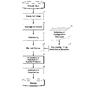
[0027] Figure 2 is a flowchart showing basic steps in one embodiment
of the
inventive method that includes two set steps (boxes have solid lines) and six
optional ones
(boxes of dashed lines) that depend on inputs, assumptions made, and the mode
in which the
system is used. In step 2, attributes are generated that relate to elements of
the hydrocarbon
system or specific play elements. In step 5, the data are analyzed and
locations are ranked
with regard to the attributes, thus identifying potential prospects that are
then stored for
further analysis or visualization.
[0028] Optional step 1 defines the fabric of the subsurface, i.e., the
geometries of the
subsurface strata and their deformation by faults and folds that form the
basis for the
computation of some attributes or may be needed by other computations to
aggregate
information from similar strata. Many attributes that are useful for the
inventive system are
formed by integrating or averaging more traditional attributes along the
fabric. In the
- 10 -
CA 02799504 2012-11-15
WO 2011/149609 PCT/US2011/033519
optional step 3, the data are separated into at least two segments or
partitions for analysis and
prospect definition. Optional step 4 is the formation of normalized scores for
elements of the
hydrocarbon system using one or more of the attributes. Optional step 6 is the
analysis of the
formed and ranked prospects; for example, identification of the least
expressed element(s)
that should be examined further. Optional step 7 is the definition or
selection of at least one
specific concept or play type that is to be searched instead of a generic
search for neighboring
elements of the hydrocarbon system. Finally, optional step 8 is the
definition, creation, and
management of a catalogue of play types and the configuration of their
elements.
[0029] A
schematic application of the inventive method is presented in Fig. 3 where
seismic attributes 32 are computed from seismic data 31. The attributes are
then combined
33 to highlight regions (e.g. 36) that may constitute stratigraphic plays, in
this case the
buried-hill play 34 and the stratigraphic pinchout play 35.
Fabric Definition
[0030] An
attribute is a measurable property of seismic data, such as amplitude, dip,
frequency, phase and polarity. Attributes can be measured at one instant in
time or over a
time window and may be measured on a single trace or set of traces or on a
surface
interpreted from seismic data, a window of data, or even on multiple seismic
volumes
simultaneously. The present inventive method uses many of the classical
attributes that are
well-known to those experienced in the art of attribute analyses or seismic
interpretation. For
the inventive method, however, some of these attributes are modified, for
example by
integration along strata or structure, to emphasize regional variations over
local ones.
Moreover, novel geologic attributes (2) are disclosed that directly relate to
hydrocarbon
system elements or play elements, and the particular configurations of these
elements. Since
geologic attributes may be embodied in alternate ways and different geologic
attributes may
relate to the same element or configuration of elements, scores (4) may be
computed that
synthesize the different embodiments and attributes together to one measure
that estimate the
chance of encountering a particular play or hydrocarbon-system element or a
particular
geometric arrangement of such elements. The scores are then combined (6) into
likelihoods
for the configurations that may be used for visualization, analysis, or rating
and ranking.
[0031] With regard to Fig. 2, less than all the illustrated steps may be
required to
implement a particular embodiment of the invention. Individual steps may be
combined or
separated into multiple components.
Furthermore, additional and/or alternative
methodologies may employ additional steps not shown herein. While the flow
chart
-11-
CA 02799504 2012-11-15
WO 2011/149609 PCT/US2011/033519
illustrates various actions occurring serially, it should also be appreciated
that some actions
could occur in series, substantially in parallel, and/or at considerably
different points in time.
Steps may also be repeated. One example of these variations is step 1, the
definition of the
fabric, structure or layering structure.
[0032] The fabric may not be needed for some attributes used in the
invention and
thus, when using only such attributes, the fabric definition may be ignored.
Most attributes
used for the inventive method, however, will require a fabric for their
formation. The fabric
could be computed on the fly for every attribute as needed. Preferably,
however, the fabric is
generated only once, then stored and used repeatedly to generate, modify, or
integrate
attributes. Step 1, the formation of the fabric, is shown as an optional step,
because depending
on the attributes used in different embodiments of the inventive method, the
fabric could be
computed once, repeatedly, or not at all.
[0033] An advantage of generating the fabric once is consistency
between different
attributes, because all are based on the same fabric. A disadvantage of
generating it only
once is that the resulting fabric needs to be represented and stored in some
manner that may
be inefficient or even unsuitable for some applications of attribute
generation, modification,
or integration. Alternatively, each application may generate its own fabric in
a suitable and
efficient representation that may cause inefficiencies for the overall system
because the same
fabrics with the same representations may be computed multiple times. Yet
another option is
to compute the fabric with a few select methods and representations that are
stored and thus
reusable. With this alternative method, the disadvantages are increased
storage requirements
and repeated access to the storage media. In practice, the preferred method
may be to
compute and store the fabric, or components thereof, for some of the more
common methods
and representations, and compute less common ones when needed.
[0034] Methods for computing the fabric may be based on dip, orientation or
strike
estimates; structure tensors, waveform correlations, or skeletonizations. One
particular way
of estimating dip and dip orientation is by use of gradients on seismic data
in the two
horizontal directions and the vertical direction (e.g., U.S. Patent No.
6,850,864 B2, "Method
for analyzing dip in seismic data volumes" to Gillard et al.). Another dip
estimator is based
on plane-wave deconstruction filters (e.g., "Applications of plane-wave
destruction filters" by
Fomel, Geophysics 67(6), 1946-1960, (2002)). Methods based on the structure
tensor allow
computation of vectors normal and tangent to seismic reflections (e.g.,
"Estimating Seismic
Heterogeneity with the Structure Tensor" by Imhof, 67th EAGE Conference &
Exhibition,
- 12 -
CA 02799504 2012-11-15
WO 2011/149609 PCT/US2011/033519
(2005); or U.S. Patent No. 7,454,292 B2, "Inverse-vector method for smoothing
dips and
azimuths" to Wang et al.). Dips may be resolved into time shifts for the
automatic picking of
surfaces (e.g., "Flattening without picking" by Lomask et al., Geophysics
71(4), P13-P20
(2006)).
[0035] An alternative method of computing reflection dip and azimuth is
based on the
gradient of isocontours. Gradient is a local vector that characterizes the
steepest increment
direction of a function. Treating seismic data, amplitude for example, as a
function f in three
dimensional space (x,y,t), the gradient is defined as Vf. Since there are
three components in
the resulting gradient vector Vf, only three neighboring samples are needed to
estimate Vf to
first order. Using more surrounding samples, however, allows estimation of the
gradient
from an over-determined system, for example in the least-squares sense, or
employing a
higher-order approximation to the finite-difference approximation. In either
case, the
resulting gradient will be smoother. The selection of neighbor points is not
limited to any
particular sequence or pattern. Rather, the neighborhood can be defined as
points or voxels
arranged in a sphere, a cylinder, a box, or any other type of shape
surrounding the point of
interest. Moreover, this shape may be aligned to the fabric or an estimate
thereof at every
point. Derivative attributes can then be derived from this gradient, including
magnitude and
direction, i.e., dip and azimuth in 3D. Gradient, as ordinarily defined,
always points in the
direction of increasing amplitude. In seismic data with amplitudes cycling
from negative
troughs to positive peaks and back, the result would be that parallel layers
exhibit opposing
dip values. One solution is to normalize the gradient with regard to one half-
space by
flipping its direction, for example to invert the sign of the gradient such
that all gradient
points are oriented in the positive y direction:
f ______________________________ sgn(fy ) fx
f V ____________________________
0 = sgn(fy ) = arctan ________ and a)= arctan or w= arctan L. 2 2 x + fy
v ft 2 fy2 fy
This gradient calculation is a more robust formulation than existing gradient
calculation
methods. It also has multi-scale capability, since the window size (number of
neighbor
points) within which the gradient is computed can be varied.
[0036] Lateral correlation of waveforms is another method of
generating a fabric. In a
first step, events such as peaks, troughs, and/or zero crossings are
determined. In a second
step, waveforms around these events are compared with the events of
neighboring traces to
find and connect the most similar ones. Note the asymmetry that occurs in that
each event
- 13 -
CA 02799504 2012-11-15
WO 2011/149609 PCT/US2011/033519
connects to only one other event, namely, the most similar one. Multiple
events, however,
may connect to one and the same event. The result is a directed graph
structure where the
vertices correspond to events such as peaks, troughs, and/or zero crossings;
and edges
connect individual events to the most similar ones in the neighboring traces.
Starting at one
event in a particular trace, it is often possible to follow directed edges
between events and
traces and later return to a different event in the original trace, which
indicates stratigraphic
(or topologic) inconsistencies. To distinguish this method from others, the
terms raw
skeleton or raw skeletonization will be used, if necessary.
[0037] A preferred method for computing a fabric is by topological
skeletonization,
which automatically creates reflection-based surfaces in a topologically
consistent manner
where individual surfaces do not overlap themselves and sets of multiple
surfaces are
consistent with stratigraphic superposition principles (PCT Patent Application
Publication
WO 2009/142872 Al, "Seismic Horizon Skeletonization" by Imhof et al.). To
distinguish
this method from others, the terms topologic skeleton or topologic
skeletonization is used, if
necessary. In this method, the topologically consistent surfaces are labeled
monotonically in
a top-down fashion, which allows assignment of a pseudo age to every sample of
the seismic
data and conversion of seismic data from the traditional geophysical depth or
two-way-time
domain to a geologic age domain (e.g., U.S. Patent No. 6,850,845 B2, "System
for multi-
dimensional data analysis" to Stark; PCT Patent Application Publication WO
2009/142872
Al, "Seismic Horizon Skeletonization" by Imhof et al.; and continued in U.S.
Patent
Application Publication No. 2010/0149917 "Method for Geophysical and
Geological
Interpretation of Seismic Volumes in Depth, Time, and Age" by Imhof et al.). A
resultant
age mapping volume and/or depth mapping volume allow transfer of data between
the
geophysical depth (or two-way-time) domain and the constructed geologic age
domain and
vice versa. Each horizontal slice through a depth mapping volume corresponds
to a depth (or
time) structure map for a particular horizon.
[0038] Yet another skeletonization method is based on morphological
thinning; the
result will be termed morphological skeleton. Seismic data are blocked to
binary images, for
example by reducing the data to just their polarities, e.g., 1. Bands of
value +1 are reduced
to lines with a value of +1 with equal connectivity, for example by
application of
morphological thinning. Bands of value -1 are reduced to lines with a value of
-1. All other
samples are set to zero. A similar result is obtained from the apparent
polarity attribute that is
formed by the polarity of instantaneous phase computed at the local amplitude
extrema.
- 14 -
CA 02799504 2012-11-15
WO 2011/149609 PCT/US2011/033519
[0039]
Another aspect of computing the fabric relates to faults that may be detected
as discontinuities on seismic data (e.g., U.S. Patent No. 6,516,274 B2,
"Method for imaging
discontinuities in seismic data using dip-steering" to Cheng et al.; or PCT
Patent Application
Publication WO 2009/082545 Al ("Detection Of Features In Seismic Images" by
Kumaran
and Wang). Detected fault segments may be further cleaned up or refined (e.g.,
U.S. Patent
No. 7,203,342 B2, "Image feature extraction" to Pedersen).
Geologic Attributes
1.a
Generation of Regional Attributes by Long Distance Structure Oriented
Smoothing
[0040] A geologic attribute is a seismic attribute that highlights or
quantifies some
aspect of the hydrocarbon system or a play. Geologic attributes are often
regional in nature.
They may, for example, estimate a seismic data property over tens or hundreds
of voxels.
Over such distances, attributes are preferably computed along the fabric in a
structure-
oriented manner to prevent mixing and thus contamination from other strata
cutting through
the analysis window.
[0041]
Given the fabric as defined by the original seismic data volume, any attribute
may be converted to a regional attribute by integrating or averaging it along
the fabric. One
such method is based on nonlinear, anisotropic diffusion filtering (e.g., U.S.
Patent No.
6,725,174 B2, "Edge-preserving enhancement of seismic images by nonlinear
anisotropic
diffusion" to Bouts et al.), which smoothes seismic data predominantly along
the direction of
the reflections. Traditionally, the fabric or the directions of the
reflections are computed
using the seismic structure tensors for the given seismic dataset that is to
be smoothed, but
the fabric can be defined with any method. Some are disclosed herein.
[0042] In
the present invention, nonlinear anisotropic diffusion may be used to
compute the fabric for the primary seismic amplitude volume, but then that
fabric is used to
smooth a secondary dataset along the direction of the reflections in the
primary seismic
amplitude volume. In some cases, this secondary dataset may not even be
layered or banded,
which prevents computation of its own proper structure tensor. In cases where
the secondary
dataset is banded, it may nevertheless be advantageous to smooth it along the
fabric of a
reference seismic volume, for example to enhance consistency between different
datasets
after structure-oriented smoothing.
- 15 -
CA 02799504 2012-11-15
WO 2011/149609 PCT/US2011/033519
[0043] An alternative method of structure oriented smoothing over long
distances in
the present invention is based on line integral convolution (LIC). Line
integral convolution is
a well-known texture synthesis algorithm used in image processing or data
visualization
("Imaging Vector Fields Using Line Integral Convolution" by Cabral and Leedom,
Proceedings of ACM SigGraph 93, 263-270, (1993)). A low-pass filter is used to
convolve
an input noise texture, for example a random noise image, along pixel-centered
symmetrically bi-directional streamlines to exploit spatial correlation in the
flow direction.
Often, the streamlines are not represented by curves but by a vector field
whose vectors are
tangent to the streamlines, and the streamlines are computed by integration.
[0044] Substituting some seismic attribute data for the noise texture and
using the
fabric to define the streamlines allows using line integral convolution to
filter the given
attribute along the fabric, which is a new approach to structure-oriented
filtering. Preferred
fabric definitions are based on dip, for example as computed from structure
tensors. Further
efficiency is gained by discretizing the fabric, or more specifically the dips
or reflection
tangents, to 0, 45, 90, 135, 180, 225, 270, or 315'; i.e., purely lateral,
purely vertical, or
purely diagonal, which replaces the numerical integration and associated
interpolation with
movement along a linked list. Since seismic data are typically more or less
horizontally
banded, further efficiency is gained by forcing all tangents to go from left
to right which
reduces the dips to 0, +45, and -45 . Figure 4 illustrates the application of
a line convolution
filter where the gray crosses indicate the location of the samples and the
arrows indicate the
discretized dip directions. The filters are applied at the locations indicated
by the heavy black
dots. The drawing shows how the filter stencils centered at the dots follow
the vectors and
thus illustrate the fabric gathering the sample values, marked with black
crosses, along these
paths.
[0045] To render the line integral convolution filter more robust in the
presence of
faults and other complexities, it can be made edge preserving by applying the
filter in
multiple stencil configurations that are not necessarily centered at the
current sample location
(illustrated in Fig. 5). Out of all tested stencil configurations, the one
that exhibits the least
variance among its samples is preferably ultimately applied at a particular
location.
Depending on the filter coefficients and the nature of the attribute that is
being treated with
such an edge-preserving line convolution integral filter, criteria other than
minimal variance
may be appropriate. Other possible criteria include maximal variance, minimal
or maximal
output, and/or avoidance of especially flagged sample locations.
- 16 -
CA 02799504 2012-11-15
WO 2011/149609 PCT/US2011/033519
[0046] The filter coefficients do not need to be uniform, which allows
for application
of differentiators (high-pass filter), integrators (low-pass filters), or
combinations thereof
The filters may be linear or nonlinear, for example median filters or mode
filters. Figure 6
illustrates that the filter stencil can have an arbitrary shape that is
deformed to conform to the
vector path through the current sample location. Figure 7 shows an example
application of
such filtering tools, converting a local attribute to a regional one.
[0047] Yet another method used to perform structure oriented filtering
over long
distances involves the exploitation of surfaces obtained by seismic
skeletonization (PCT
Patent Publication No. WO 2009/142872 Al, "Seismic Horizon Skeletonization" by
Imhof et
al.), where the skeleton surfaces provide the fabric along which the
attributes are filtered.
Instead of smoothing along discrete surfaces, which may require interpolation,
smoothing can
be performed along isosurfaces of the age mapping volume constructed from the
skeleton
surfaces. Alternatively, the attribute can be transformed from the traditional
domain of depth
or geophysical two-way traveltime to the domain of geologic age. In the
geologic age
domain, a horizontal slice corresponds to one horizon, and thus, smoothing or
filtering of
horizontal slices is by definition structure oriented (U.S. Patent Application
No. 12/623,034
"Method For Geophysical and Geological Interpretation of Seismic Volumes In
Depth, Time,
and Age" by Imhof et al.). After filtering in the age domain, the results can
be transformed
back to the domain of depth or two-way traveltime.
[0048] Independent of the method used for structure-oriented filtering,
geologic
attributes can be computed as multi-scale attributes because the filter size
is specified by
either the interpreter or the system. Instead of computing a geologic
attribute at only one
scale, an interpreter or system may choose multiple filter sizes, allowing
computation of the
same geologic attribute at different scales.
1.b Hessian Attributes
[0049] A new seismic attribute of the present invention is the Hessian
or second-order
spatial derivative (dyadic) tensor H= VVf, , which is computed in a similar
fashion as the
modified gradient. At every location of interest, the Hessian in three
dimensions can be
represented by a symmetric 3x3 matrix, i.e., by six independent components. To
compute the
Hessian at any voxel location, at least six neighboring voxels are needed,
since it has six
independent components. The calculation, however, can involve more voxels to
obtain
smoother and more stable estimates for the Hessian: by calculating its
components from an
over-determined system, for example in the least-squares sense, or employing a
higher-order
- 17 -
CA 02799504 2012-11-15
WO 2011/149609 PCT/US2011/033519
approximation to the finite-difference approximation of the spatial
derivatives. The selection
of neighbor points is not limited to any particular sequence or pattern.
Rather, the
neighborhood can be defined as points or voxels arranged in a sphere, a
cylinder, a box, or
any other type of shape surrounding the point of interest. Moreover, this
shape may be
aligned to the fabric or an estimate thereof at every point.
[0050] From a geometrical point of view, the seismic data volume
consists of point
features (e.g., noise), curvilinear features (e.g., terminations or channels),
surface features
(e.g., faults), or volume features (e.g., channel belts or salt bodies)
embedded in layered
background structure. In current practices, directional second-order
derivatives of amplitude
or trace correlation signals are usually calculated to detect heterogeneities
that typically occur
at geological features such as faults, erosion boundaries, and pinch-outs.
Lacking cross
derivatives, attributes based on traditional second-order derivatives
represent local variations
in the data incompletely. With its six components, the Hessian characterizes
the local
convexity or concavity of the seismic data. The traditional second-order
derivatives are
found on the diagonal of the Hessian, while the cross-derivatives are found
off-diagonal.
Attributes can thus be formed from these six components and combinations
thereof The
components, and therefore the attributes, are formed from second-order
derivatives of a
seismic volume and show spatial change in gradient. They reflect spatial
changes in dip and
azimuth angles in the seismic volume, which allows highlighting anomalous
regions and
groups of interrelated features. By highlighting different types of
"discontinuities" and their
spatial interrelationships, seismic volumes can be characterized and
visualized better.
[0051] Another use of the Hessian is to serve as an intermediate step
for calculating
spatial curvatures, as illustrated in the next section. In addition,
eigenvalues of the Hessian
matrix and projections of the Hessian onto certain surfaces also form measures
of how curved
the isocontours are.
[0052] Curvature measures the degree to which an object, a surface for
example,
deviates from being flat. However, specific definitions depend on context. For
example,
curvature can be defined for a plane or a space curve, in which case it is a
scalar. It can also
be defined for a parameterized surface embedded in three-dimensional space, in
which case it
is a tensor. With the objective of discovering attributes related to
stratigraphy, two new types
of curvature are defined here. The first is isocontour curvature in a two-
dimensional seismic
image. An arbitrary two-dimensional cross-section through a seismic volume is
treated as a
- 18 -
CA 02799504 2012-11-15
WO 2011/149609 PCT/US2011/033519
map of a function f(x,y). An isocontour is the curve in this cross section
whose coordinates
satisfyf(x,y)= constant. Its curvature is defined as
- fõõf2 y + fyyfx2 2ffxfy
(f2 +f2)312
where all quantities are defined by components of the isocontour gradient
vector or Hessian
tensor. This curvature attribute can be particularly useful in highlighting
geometric features
of high curvature, such as terminations, corners, and junctions.
[0053] Another definition of isocontour curvature is based on a
generalization to three
dimensions. The seismic data are treated as a function of three independent
variables f(x,y,t).
All voxels that satisfy f(x,y,t) = constant constitute an isosurface, i.e., a
curved surface
embedded in three-dimensional space. For a curved space, curvature is a tensor
quantity that
allows extraction of multiple scalar quantities related to curvature such as
the principal
curvature, mean curvature, and Gaussian curvature. For such a curved surface,
one may
define a surface normal by normalization of the isocontour gradient n = Vf /
IVf 1. Surface
tangents may be defined using the condition t = n = 0. Note that there is an
infinite number of
tangents that satisfy this condition at any given point on the surface. And
there are just as
many orthogonal planes to the surface defined by a tangent t and the normal n.
The
intersection of such a plane with the surface is a curve whose curvature is
called the normal
curvature. The maximum and minimum of all normal curvatures are termed the
principal
curvatures K1 and K2, from which the Gaussian curvature is computed as the
product
K = K1.K2, while their algebraic average obtains the mean curvature M= (Ki+
K2) I 2.
[0054] All of these quantities are defined for each point in space,
and they can be
expressed compactly as a matrix S known as the Shape operator. To build one
convenient
embodiment of S, note that the space of all tangents at the given point can be
expressed as the
eigenvectors of a matrix T obtained by subtracting the outer product of the
normal with itself
from the identity matrix, T = (I - nn). T effectively projects any three-
dimensional vector
onto the tangent plane. Thus, one can measure the change of the gradient
restricted to that
plane by multiplying the Hessian matrix by T, or symbolically H' = HT, where =
denotes
the inner, or matrix, product. Finally, S is obtained by normalizing the
Hessian: S = H' / IVf
12. The principal curvatures are the eigenvalues of S, dividing the trace of S
by two yields the
- 19 -
CA 02799504 2012-11-15
WO 2011/149609 PCT/US2011/033519
mean curvature, M= trace(S) / 2, and the determinant det(S) =K defines the
Gaussian
curvature.
[0055] All of these curvature measures can be treated as seismic
attributes and can be
used to detect horizon terminations and junctions that define features of
geologic importance,
such as faults, erosional truncations, pinchouts, and other geometric
relations.
[0056] The isocontour attributes are in the form of vectors and second-
order tensors.
Projections of these attributes onto particular directions and surfaces may
characterize the
seismic volume better than any individual component thereof Projection of the
gradient onto
any direction is simply the dot-product between the gradient vector and a unit
directional
vector. Such a projection defines the directional derivative of an isocontour
function along a
particular direction. The larger this projection (or directional derivative)
is, the steeper the
change in amplitude along that direction. Similarly, the projection of the
Hessian onto a unit
directional vector d is the second-order derivative of an isocontour function
along that
direction and can be computed as fdd = d=II=d, where = denotes the inner, or
dot, product. For
the Hessian, projections of particular interest are along the gradient
direction, the dip
direction, or the direction orthogonal to the plane spanned by both gradient
and dip.
[0057] Gradient of the isocontour dip volume and its projections also
contain useful
information of the subsurface structure. Dip gradient quantifies variations of
dipping
direction in the original volume. The projection of dip gradient along dip
direction is a
measure of the rate of change of dip. This helps to detect curved features on
the reflectors,
such as ridges, mounds, holes, and valleys. The projection of dip gradient
onto a vector that
is normal to the dip direction defines a measure of the rate of reflector
convergence or
divergence.
[0058] While these isocontour attributes (gradient, dip, orientation,
Hessian,
curvature, and projections) can be used as local attributes, the results can
be affected by
artifacts in areas contaminated with noise or areas with high complexity.
Smoothing reduces
such artifacts and can be performed, for example, by convolution with a broad
lowpass filter
or application of a large-windowed median filter. Preferably however,
smoothing is
performed in a structure-oriented manner over longer distances along the
fabric to prevent
mixing across strata. By application of a long-distance, structure oriented
filter, local
isocontour attributes can be converted to geologic attributes.
- 20 -
CA 02799504 2012-11-15
WO 2011/149609 PCT/US2011/033519
1.c Convergence
[0059] Another new geologic attribute of the present invention is
convergence, which
detects where seismic reflections converge to form a trend of regional
thinning of reflection
packages, highlighting pinchouts, wedges, or stratigraphic onlaps and
downlaps. The
convergence attribute can be used to emphasize stratigraphic features to an
interpreter or as
input to an assisted or automated pattern recognition system, such as the
seismic hydrocarbon
system analysis system of the present invention. Two methods of computing
convergence
are: by use of the Hessian or by use of the gradient of dip in directions
normal to the fabric or
dip. Depending on the neighborhood used to compute the Hessian or gradient,
structure-
oriented long-distance smoothing along the fabric may be employed using line
integral
convolution, a diffusion filter, a skeleton-guided filter, or filtering in the
age domain. Each of
these uses the original seismic data to guide the filter along the reflectors.
[0060] Another method to compute the convergence attribute is to first
measure local
reflector thickness, then estimate a local lateral thickness derivative, and
finally, perform a
lateral smoothing operation along the reflections to obtain regional
convergence trends. If the
trends are estimated on single, two-dimensional cross sections, then
convergence can occur to
the left or right, or alternatively be called convergence and divergence along
one reference
direction, for example left to right. If the trends are estimated from
orthogonal slices
extracted from a 3-D dataset, then convergence can be associated with an
orientation and
magnitude. Moreover, the trends can also be estimated in a volumetric sense
using three-
dimensional analysis windows instead of multiple orthogonal two-dimensional
ones.
[0061] Methods to estimate local reflector thickness include: loop
duration, the
distance between juxtaposed extrema or zero crossings; instantaneous
frequency, or the time-
difference between two juxtaposed surfaces of the seismic skeleton. A
continuous attribute
such as instantaneous frequency may need to be blocked. Any such thickness
attribute can be
differenced laterally to estimate the rate of local thickness changes. The
rate of local
thickness changes may also be estimated from the divergence of a vector field,
for example
reflection normals, or from the divergence of a tensor field, for example
reflection tangents.
[0062] To obtain regional convergence trends, local thickness
derivatives are
smoothed with a structure-oriented long-scale filter operator along the fabric
using line
integral convolution, a diffusion filter, a skeleton-guided filter, filtering
in the age domain, or
any other method that uses the original seismic data to guide the filter along
the reflectors.
- 21 -
CA 02799504 2012-11-15
WO 2011/149609 PCT/US2011/033519
For computational efficiency, the labels or horizon indicators may be encoded
with the
derivatives.
[0063] Figure 7 shows the convergence attribute based on loop
duration, lateral
derivative, and using the line integral convolution to enhance the long-
distance convergence
trends. By performing this procedure over both inlines and crosslines, a three-
dimensional
convergence attribute with magnitude and orientation can be constructed (Fig.
8).
1.d Confluence
[0064] Yet another new geologic attribute of the present invention is
called
confluence. Seismic reflections are treated as a network of roads carrying
traffic, and some
of these roads are congested because they are joined by many others.
Confluence measures
this congestion by estimating how many paths pass through any given voxel. In
terms of
seismic stratigraphy, branching and merging reflections produce terminations
in the forms of
downlaps, onlaps, toplaps, and truncations, as depicted in Fig. 9. All of
these terminations
are potentially associated with unconformities; downlaps may also be
associated with
downlaps surfaces, i.e., flooding or transgressive surfaces.
[0065] One family of methods used to compute confluence is based on
the density of
flow lines specified by the reflection tangents. Flow lines are either
computed by integration
of the tangent field or simply by following a chain of discretized tangent
directions. Starting,
for example, with the leftmost trace, a new flow line can be initiated and
propagated toward
the right. New flow lines are initiated either at regularly spaced increments
of depth or two-
way traveltime, or at specific events such as peaks (maxima), troughs
(minima), and/or zero
crossings. Samples on a flow line, and preferably in a small zone around the
flow line, are
marked to belong to that particular flow line. Once all flow lines in the
first trace are initiated
and marked, the algorithm proceeds to the neighboring trace on the right and
begins to initiate
and mark additional flow lines, either at regular increments in as-of-yet
unmarked areas or at
as-of-yet unmarked events. Flow lines may be traced and marked either to the
left or to the
right; preferably, the flow lines are computed and marked both to the left and
the right of the
current trace. Once all unmarked areas or events have been used to initiate a
flow line, and
thus are marked, the process repeats with the next trace.
[0066] When every sample or event has been marked at least once, confluence
is
determined by computing how many times each sample has been marked.
Preferably, this
calculation is preformed simultaneously with the sample/event marking by
simply
- 22 -
CA 02799504 2012-11-15
WO 2011/149609 PCT/US2011/033519
incrementing counters associated with the sample locations. While these steps
can be
performed from left to right, preferably they are repeated from right to left
as well and then
added to the previous result, ensuring symmetry. Marking of the samples in a
region around
a flow line may be performed with a constant indicator or with values that
vary depending on
their distance from the flow line. The variable indicator weights, for
example, could
resemble a triangle or a Gaussian. Neglecting the issues of when and where to
initiate new
flow lines, one could simply mark and count flow lines without marking any
regions and
then, afterwards, perform a smoothing operation, for example with a boxcar, a
triangle or a
Gaussian filter.
[0067] Instead of tracing flow lines all the way from left to right (and
vice versa),
flow lines can be computed for only a finite distance from the initiation
point. This
computation can be performed by line integral convolution or, preferably, a
variation thereof
that simply increments the counters of the samples touched by the stencil.
[0068] Generalizations of these flow line-based embodiments of
confluence to three-
dimensional data may be obtained by performing computations independently
along inline
and crossline directions or along a set of arbitrary directions.
Alternatively, flow lines
(curves) may be generalized to flow sheets (surfaces), or line integrals may
be generalized to
surface integrals.
[0069] Other embodiments of confluence can be obtained using seismic
skeletons.
The raw skeleton is represented by a directed graph of events (peaks, troughs,
and zero
crossings: vertices) and a waveform correlation with events in neighboring
traces (edges).
From a particular vertex (event), the graph can be traversed to the left
and/or to the right by
following the edges (correlations). Initiating graph traversals from different
vertices allows
counting how often any given vertex gets passed through. Either every vertex
is used to
initiate a traversal, or preferably, only vertices that have not been passed
through yet are used
to initiate a new traversal. In the preferred case, at first every vertex will
initiate a traversal,
but progressively, vertices will have been passed through at least once and
initiation of new
traversals will become increasingly rare. This particular graph-traversal
embodiment of
confluence can also be based on morphological skeletons.
[0070] Two other embodiments of confluence are based on the topological
skeleton.
First, one can count how many different surfaces overlay or underlay any given
surface. If
one surface below another particular surface terminates, then a new surface
must exist below
the original (non-terminating) one. The count of how many different surfaces
are above and
-23 -
CA 02799504 2012-11-15
WO 2011/149609 PCT/US2011/033519
below a given surface therefore approximates the number of terminations
against it. By their
nature, large surfaces tend to have high counts. Normalizing the counts by
surface size,
however, tends to assign high relative counts to the tiniest surfaces, because
a small number
of counts is divided by a small area or the small number of samples forming
the surface.
Thus the counts need to be normalized. One normalization method involves using
the surface
area raised to some power, for example one half A preferred normalization,
however, is
based on the analysis of the significance of encountering a certain number of
terminations on
a surface of a particular size. For a small surface, for example, there is a
chance of
encountering a large number of terminations relative to the surface size, and
thus, this count
may not be statistically significant. For a large surface, though, even a
small termination
count may be above average in a statistically significant manner. The
termination probability
of a surface can be estimated by averaging the individual relative termination
counts, some
weighted version thereof, or from the total number of surfaces divided by the
total area of
these surfaces. Once an expected termination probability (or density) is
calculated, a
binomial test can then be used to compute the statistical significance of a
deviation from the
expected number of terminations for a surface of a given size. For large
surfaces, the
binomial distribution is well approximated by convenient continuous
distributions, and these
can be used as the basis for alternative tests that are much quicker to
compute, i.e., Pearson's
chi-square test and the G-test. However, for small samples these
approximations break down,
and there is no alternative to the binomial test.
[0071] Another confluence embodiment derived from topological
skeletonization is
based on the age mapping volume associated with the surfaces. Areas of high
confluence
have a high density of flow lines or flow sheets. An isocontour or an
isosurface in the age
mapping volume is similar to a flow line or a sheet derived from reflection
tangents. Thus, a
high density of isosurfaces indicates an area of high confluence. A preferred
alternative to
the construction of isosurfaces and estimation of their density is the
computation of a gradient
or vertical derivative of the age mapping volume. Areas with high gradients or
high
derivatives have high confluence.
[0072] Any embodiments of confluence may further be smoothed by
application of a
long-distance smoother, for example a line convolution integral.
1.e Closure and Spill Points
[0073] Another set of geologic attributes, disclosed in U.S. Patent
Application
Publication No. 2010/0149917, "Method for Geophysical and Geological
Interpretation of
- 24 -
CA 02799504 2012-11-15
WO 2011/149609 PCT/US2011/033519
Seismic Volumes in Depth, Time, and Age" by Imhof et al., are enclosure and
spill point. In
traditional interpretation practices, a horizon is analyzed to determine the
existence of closed
contours encircling a topographic high spot, forming a closure, that could
trap hydrocarbons.
Note that closure can be implicit, for example where the contour lines
terminate at a fault or
against a salt dome and are implicitly assumed to follow these boundaries. For
each closed
contour, enclosure specifies the area contained within. Thus, any location on
a surface can be
analyzed to determine whether or not it lies on a closed contour encircling a
high spot and, if
so, the encircled area can be computed. For each high spot, its maximum
enclosure specifies
the maximum extent of the potential hydrocarbon trap.
[0074] Closures and enclosures can be determined for any single horizon or
for any
set of horizons, for example surfaces mapped by traditional means or by
automated
skeletonization. By estimating enclosure either for every surface in a
dataset, from the age
volume, or preferably from the depth volume, an enclosure volume can be
computed that
assigns every sample a value of zero if it is not part of a closed depth
contour that encircles a
high spot. Otherwise, the area of the encircled area is assigned to the sample
location.
[0075] Using the age volume, a surface can be constructed by selection
of an age, or a
location, or some other criteria. This surface can be analyzed for high spots,
contours that
encircle the high spots, and their areas. Preferably however, the depth volume
is used. Each
horizontal slice in a depth volume represents a surface at some age. In fact,
a depth volume is
nothing more than a stack of surfaces ordered by age. For each slice (or
surface of some
age), its values correspond to depth and thus each slice constitutes a depth
map. Each slice
can be analyzed for high spots, closed contours, and enclosed areas, which
allows
computation of an enclosure volume in the age domain. If desired, the entire
enclosure
volume or a part thereof, a slice for example, can be easily transformed to
the depth domain.
[0076] An extension of closure or enclosure volumes is spill points and
spill point
volumes. The spill point is a location near the maximum closure contour where
the contours
are breached and thus, the potential trap leaks (Fig. 1). Determination of all
spill points
allows creation of a spill point volume and examination of how different
potential traps spill
and feed each other. The locations and number of spill points can be used for
risking a
prospect or to guide a search for regions where hydrocarbons leaked from and
accumulated
to. Although spill points can be identified from age volumes by extraction of
isoage surfaces
and examination thereof, spill points and spill point volumes are preferably
generated from
depth volumes that correspond to stacks of depth maps of different age (i.e.,
stacks of depth
- 25 -
CA 02799504 2012-11-15
WO 2011/149609 PCT/US2011/033519
maps for different horizons). If necessary, spill points and spill point
volumes determined
from depth volumes can be easily transformed to the depth domain by use of the
depth
volume as a lookup table or by interpolation.
1.f Phase Residues
[0077] Another geologic attribute can be formed from instantaneous phase
anomalies,
which point out locations where the seismic wavelet splits (PCT Patent
Application
Publication WO 2009/137150 Al, "Method For Geophysical And Stratigraphic
Interpretation
Using Waveform Anomalies" by Imhof). The instantaneous phase anomaly attribute
is a
discrete attribute indicating whether or not a wavelet split occurs at a
sample location.
Traditional convolution with a boxcar filter allows computation of a local
density of wavelet
splits. Long-distance structure oriented smoothing, for example with a line
integral
convolution, allows computation of density of wavelet splits that is
consistent with the
underlying seismic fabric. Preferably, the wavelet split loops and strings are
first classified
based on their shape and orientation to suppress wavelet splits caused by
noise or artifacts.
[0078] Phase residues occur at locations where waveforms split, which
implies that an
additional reflection event commences or that one reflection merges into
another one. In other
words, a termination occurred. Terminations are often classified as onlap,
downlap, toplap,
and truncation (Fig. 9) depending on the relations between the reflections.
Thus, phase
residues may be classified as onlaps, downlaps, toplaps, and truncations. As
an alternative to
phase residues, terminations can also be detected and classified from seismic
skeletons.
Unless dip information is used, downlaps and onlaps cannot be distinguished
and may need
to be grouped together. Without dip information, toplap and truncation cannot
be
distinguished and need to be grouped together. Terminations and their
classification can be
posted on surfaces or confluence flowlines. Preferably, terminations and their
classifications
are converted to densities or geologic attributes by smoothing. Particularly
useful geologic
attributes based on terminations are termination densities such as the
onlap/downlap density,
the truncation/toplap density, or the difference between the onlap/downlap
density and the
truncation/toplap density that indicates which behavior dominates.
1.g Texture
[0079] Other geologic attributes are based on seismic texture. U.S. Patent
No.
6,438,493 B 1, "Method for seismic facies interpretation using textural
analysis and neural
networks" to West and May discloses a method for the identification of seismic
facies based
- 26 -
CA 02799504 2012-11-15
WO 2011/149609 PCT/US2011/033519
on textural attributes computed with gray-level co-occurrence matrix (GLCM).
Local
textural attributes derived from GLCM include, but are not restricted to:
textural
homogeneity, inertia (also knows as the element-difference moment or
contrast), entropy, and
energy (also known as uniformity). Using long-distance smoothing along the
fabric, these
attributes can be converted to regional geologic attributes relating texture
to seismic facies.
The GLCM based texture attributes can further be generalized to three-
dimensional texture
attributes (e.g., U.S. Patent No. 6,226,596 Bl, "Method for analyzing and
classifying three
dimensional seismic information" to Gao).
[0080] Another texture attribute (PCT Patent Application Publication
WO
2009/011735 "Geologic Features From Curvelet Based Seismic Attributes" by
Neelamani
and Converse) identifies stratigraphic features from seismic data by taking a
curvelet
transform of the data. From this curvelet representation, selected geophysical
data attributes
and their interdependencies are extracted and used to identify geologic
features. Using long-
distance smoothing along the fabric, these attributes can be converted to
regional geologic
attributes relating to texture and seismic facies.
[0081] Yet other texture attributes are based on windowed
multidimensional Fourier
measures (PCT Patent Application Publication WO 2010/053618, "Method for
Seismic
Interpretation Using Seismic Texture Attributes" by Imhof). One particular
such measure is
regularity, a texture attribute that measures how banded (or regular) seismic
data appear to
be. Areas with clean, through-going reflections exhibit a high degree of
regularity while
noisy areas with disorganized reflections exhibit low regularity. With small
analysis
windows, regularity is a discontinuity measure. With large analysis windows,
regularity acts
as a chaos measure. Thus, regularity can also be termed multitrace
discontinuity chaos.
Using long-distance smoothing along the fabric, these windowed
multidimensional Fourier
attributes can be converted to regional geologic attributes relating to
texture and seismic
facies. For example, through-going regional reflections, commonly termed
railroad tracks,
often correspond to transgressive surfaces (or flooding surfaces) that
frequently form seals.
Thus, long-distance smoothing of regularity (or its inverse, chaos) creates a
geologic attribute
related to hydrocarbon seals and, because shales both form seals and act as
source rocks,
hydrocarbon source rocks.
[0082] Randen and Sonneland ("Atlas of 3D Seismic Attributes", in
Mathematical
Methods and Modeling in Hydrocarbon Exploration and Production, Iske and
Randen
- 27 -
CA 02799504 2012-11-15
WO 2011/149609 PCT/US2011/033519
(editors), Springer, pages 23-46 (2005)) present an overview of additional
three-dimensional
seismic attributes that characterize seismic texture or seismo-stratigraphic
features.
1.h WPCA Anomalies
[0083] Another family of attributes relevant to this invention is
disclosed in PCT
Patent Application Publication WO 2010/056424 "Windowed Statistical Analysis
for
Anomaly Detection in Geophysical Datasets" by Kumaran et al. These attributes
highlight
locations in one or multiple datasets where the seismic data are statistically
anomalous
compared to other locations. Moreover, these attributes generate a vector
basis of patterns
ranging from most common to most anomalous. Projecting the data onto a linear
combination of these patterns emphasizes some patterns while suppressing
others. For
example, the ubiquitous seismic banding can be suppressed. Using long-distance
smoothing
along the fabric, the filtered seismic can be converted to regional geologic
attributes.
Another application is the local decomposition of the data into these patterns
and
determination of the dominant one, which effects classification of seismic
samples based on
the patterns of the surrounding samples. Using a long-distance median or mode
filter along
the fabric, the local class can be converted to a regional one.
1.i Other Attributes
[0084] Another kind of attribute is based on the inversion of multi-
offset seismic data
and the observed behavior of amplitude versus offset that allows prediction of
porosity and
clay content, and allows classification of the lithofacies (e.g., U.S. Patent
No. 7,424,367 B2
"Method for predicting lithology and porosity from seismic reflection data" to
Saltzer et al.;
"Seismic Rock-Property Inversion and Lithofacies Prediction at Erha Field,
Nigeria", Xu et
al., Nigerian Association of Petroleum Explorationists (NAPE) 2008 conference
proceedings;
"Lithofacies Prediction in Deep Water Water Reservoirs", Oppert et al.,
Society of
Exploration Geophysicists, Expanded Abstracts, 1708-1711, (2006)). Using long-
distance
smoothing along the fabric, these attributes can be converted to regional
geologic attributes
relating to lithofacies, clay content, and porosity.
[0085] European Patent No. EP1110103 B1 "Method Of Seismic Signal
Processing"
to Meldahl et al. discloses a method to generate attributes that allows the
detection of
potential gas chimneys. A gas chimney is a vertical disturbance of the seismic
response from
gas seepage that degrades the seismic data due to limitations in acquisition
and processing.
The resulting chimney cube attribute highlights vertical disturbances of
seismic signals that
- 28 -
CA 02799504 2012-11-15
WO 2011/149609 PCT/US2011/033519
are often associated with gas chimneys. It reveals information of the
hydrocarbon history and
fluid flow. In other words, the chimney cube may reveal where hydrocarbons
originated, how
they migrated into a prospect and how they spilled from this prospect. As
such, a chimney
cube can be seen as a new indirect hydrocarbon indicator tool.
[0086] Moreover, Loseth et al. ("Hydrocarbon leakage interpreted on seismic
data ",
Marine and Petroleum Geology 26(7), 1304-1319, (2009)) provide a review of
seismic
hydrocarbon leakage interpretation.
[0087] Lastly, seismic attributes can be related to properties in the
subsurface that can
be used to simulate transport phenomena such as heat flow and temperature
which affect
hydrocarbon maturation, or permeability and fluid flow which affect
hydrocarbon migration
(PCT Patent Application Publication WO 2009/137228 A2, "Transport Property
Data
Calculated From Derivative Seismic Rock Property Data For Transport Modeling"
by Oppert
et al.).
1.j Combination Attributes / Play Attributes
[0088] In some embodiments of the present inventive method, the seismic
data are
examined for one or multiple specific plays instead of elements of a more
generic
hydrocarbon system. Examples could include: anticlinal plays (Fig. 10), normal-
fault plays
(Fig. 11), salt-dome flank plays (Fig. 12), shoestring channel plays, or
others, such as
illustrated in Figs. 13 to 16. In these cases, attributes, detectors or
workflows are needed to
distinguish specific features such as faults, salt, or channels.
[0089] PCT Patent Application Publication WO 2009/082545 "Detection of
Features
in Seismic Images" by Kumaran and Wang discloses one such method for the
detection of
channels or faults in seismic data. For fault detection, edges are identified
in smoothed
seismic images and the edge intensities are integrated in multiple directions,
for example
using the Radon transform to detect presence and orientation of fault lines.
For channels,
edges are detected and converted to smooth curves to identify channel edges.
Sets of parallel
smooth curves are then examined to find pairs of curves that correspond to
left and right
channel edges, thus defining the channel.
[0090] U.S. Patent No. 7,203,342 B2, "Image Feature Extraction," to
Pedersen
discloses another such method designed for extracting faults from seismic
attribute data,
although it can also be used for other line or surface extraction problems as
well. The method
- 29 -
CA 02799504 2012-11-15
WO 2011/149609 PCT/US2011/033519
is based on ant tracking where numerical ants or agents roam over a
discontinuity or edge-
detection volume, slowly connecting up nearby pieces of aligned edges.
[0091] A last example is the detection of salt bodies using the
regularity or chaos
attributes disclosed in PCT Patent Application Publication WO 2010/053618
"Method for
Seismic Interpretation Using Seismic Texture Attributes" by Imhof; or Randen
and
Sonneland, "Atlas of 3D Seismic Attributes" (in Mathematical Methods and
Modeling in
Hydrocarbon Exploration and Production, Iske and Randen (editors), Springer,
pages 23-46
(2005)). These attributes highlight areas in the seismic data that appear
chaotic with irregular
texture, which often correspond to salt bodies.
[0092] These are just three example methods to identify specific features.
Many
others have been disclosed and are well known to practitioners of the art.
Partitioning
[0093] In order to detect the simultaneous presence of multiple
proximal elements of
the hydrocarbon system or multiple play elements, the data volume can
optionally be
partitioned into at least one segment for analysis, maybe in conjunction with
a background
segment that is not analyzed. Typical modes of partitioning are analysis of:
individual
voxels, little blocks, fabric-aligned blocks, layers, or contiguous groups of
voxels. The
partitioning does not need to be mutually exclusive. Individual partitions may
overlap.
[0094] The simplest partitioning is voxel-by-voxel analysis, but the
results may be
patchy because seldom are all elements recognized in the same voxel and one is
unlikely to
encounter an extended region of contiguous voxels with all elements present.
Techniques
such as smoothing the attributes or extending detected elements into
surrounding voxels can
be used in step 5 of the present inventive method (Fig. 2), evaluation, to
create larger,
contiguous prospects. Partitioning into voxels is a preferred partitioning
method because the
data are often already represented as voxels. For this reason, the
partitioning step is
considered optional. Moreover, partitions (and thus voxels) can be aggregated
to larger
regions during the evaluation step. Thus for the purpose of teaching the
inventive method, if
no partitioning has been performed explicitly, then each voxel is considered
to form its own
partition.
[0095] Another partitioning scheme involves breaking the data volume into
regular
Cartesian blocks or bricks, for example samples of size 20x20x20, where the
expectation is
that some or all elements are present within a prospective brick.
- 30 -
CA 02799504 2012-11-15
WO 2011/149609 PCT/US2011/033519
[0096] Cartesian bricks will cut through strata and fabric. An
alternative to regular
Cartesian bricks or blocks is to align blocks to the fabric. In this scheme,
there will be
differences in size and shape between the partitions because they conform to
the fabric. A
particular way of generating such a partitioning is by using the fabric itself
to define a gross
layer structure. Specifically, for example, a selection of surface pieces
created by seismic
skeletonization could be extended vertically to create bodies or segments.
[0097] Another preferred method for partitioning is based on one or
multiple seismic
attributes as generated, for example, in step 2. Partitions are created by
thresholding of the
attributes followed by connected component analysis or similar to generate
contiguous
regions embedded in a background. This process is also called (multivolume)
seed detection.
A preferred attribute to control the partitioning is saliency, an attribute
that highlights
locations in one or multiple datasets where the seismic data are statistically
anomalous
compared to other locations. Saliency attributes are disclosed in PCT Patent
Application
Publication WO 2010/056424 "Windowed Statistical Analysis for Anomaly
Detection in
Geophysical Datasets" by Kumaran et al. Saliency is a generic name for an
attribute that
highlights statistical anomalies in data. Kumaran et al. disclose "inverse
covariance",
"(WPCA) residue", or "(WPCA) anomaly," terminology for specific embodiments of
saliency. Additional saliency attributes may be computed using Kumaran's
methods. The
saliency can be thresholded to perform the analysis only on contiguous
anomalous regions.
[0098] An alternative method of using attributes to control partitioning is
to first
perform a different partitioning method, for example Cartesian blocks or
fabric aligned
bodies, and to then preserve only partitions where an attribute computed for
each partition
exceeds an absolute value or a relative value, or satisfies some prescribed
condition, for
example, where the maximum saliency is in the top quintile or where the
average regularity
falls within the range between 0.3 and 0.6.
[0099] A last example of a partitioning method involves subdividing
the data volume
into small regions that are ranked by an attribute(s), e.g., saliency. For
many embodiments of
the present invention, the order in which one evaluates the prospectivity of
the different
partitions or individual voxels does not matter. This last example
demonstrates the use of an
attribute such as saliency (or size, another attribute, or a combination of
other attributes) to
determine the order in which the partitions are analyzed. Using such a
prioritization, it may
not be necessary to analyze all partitioned regions. This embodiment of the
present inventive
method begins evaluation of the hydrocarbon system (step 5) with the most
salient regions
-31 -
CA 02799504 2012-11-15
WO 2011/149609 PCT/US2011/033519
and continues with progressively less salient ones until a prescribed number
of regions has
been analyzed, a prescribed number of prospects has been found, or a
prescribed time
allowed for analysis has been exceeded.
Element Scores
[00100] Scoring may include normalization, conditioning, combining, or
scaling. For
some of the play or hydrocarbon system elements, this step takes at least one
attribute per
available element to form a score for every partition (or in the simplest
case, for every voxel)
that expresses the likelihood or expectation of a particular element being
contained in a
particular partition. Scoring is deemed an optional step because it can be
performed as an
explicit, separate step 4 as shown in the flowchart of Fig. 2. In some
embodiments of the
invention, however, it may be performed in combination with attribute
formation (step 2) or
prospect evaluation (step 5).
[0100] In the simplest form of the inventive method, an attribute is
directly used as a
score to indicate whether or not a particular element is present at any given
location or not.
Different attributes, however, can have different ranges for their values and
it is often
advantageous to normalize their values, for example between 0 and 1 or 0 to
255, for easier
comparisons between attributes or to facilitate probabilistic interpretation.
Normalization is
just a linear transformation of the attribute values.
[0101] An alternative to normalization is calibration or the
application of a nonlinear
transformation of attribute values that is either driven by data, for example
histogram
equalization or histogram transformation, or driven by a model that expresses
how an
attribute relates to the likelihood for a given element to exist. Such a model
may be based on
theory, measurements, prior or contextual knowledge, experience, or intuition.
[0102] Seismic attributes are observations, measurements, or
computations performed
on seismic data. They may relate to hydrocarbon system elements or play
elements, but often
they do not actually measure these elements. Moreover, they may not be unique.
Different
attributes may relate to the same element. The same attribute may relate to
multiple
elements, while also affected by noise, acquisition, data processing, and the
algorithm and
parameters used to generate the attribute. The same type of attribute may be
computed with
different algorithms. Combination of attributes allows the formation of one
score that
indicates the likelihood or expectation for the presence of an element at a
given location.
- 32 -
CA 02799504 2012-11-15
WO 2011/149609 PCT/US2011/033519
[0103] If for a given element, no direct attribute has been computed
that defines a
score, then the score may need to be defined indirectly using a proxy
attribute or score, a
heuristic, a concept, or a prior expectation (such as a constant value of 0.1
that simply
indicates a 10% chance for the element). Reservoir, for example, may be
directly indicated
by a sand-shale ratio estimate and/or a porosity estimate. If no such
indicator attribute exists,
then a conceptual proxy, derived for example from sequence stratigraphic
concepts, may need
to be used. Such a proxy could be a combination of a lowstand basin floor fan
that overlays
an unconformity (a sequence boundary) as shown in Fig. 17. Lowstand basin
floor fans often
exhibit good porosity and permeability, and thus have the potential to form
the reservoir
element. Rising relative sea level will cover this fan with the toes of the
lowstand wedge
likely to consist of finer, less permeable matter that is capped by a
transgressive surface.
Further rise of relative sea level will bury the lowstand beneath the
transgressive and
highstand systems tracts. At distal locations, the fan may appear to be
sandwiched between an
"unconformity" and a "transgressive" surface. Thus, a rock body between an
unconformity
and a transgressive surface, located on the deep side of said unconformity,
could be a
lowstand fan and would therefore be assigned a high reservoir score.
[0104] Another aspect of score assignment is scaling to the segments
or partitions.
Many attributes are defined at every voxel location. Others may only be
available on
surfaces or at a few select locations. A particular partition may correspond
to one voxel or to
a contiguous set of voxels. In order to assign a score to every partition (or
in the simplest
case every voxel), attributes may need to be interpolated or reduced to obtain
a single score
per partition. For a partition that contains multiple samples, a
representative score may be
found by computation of the mean, the median, or the mode; application of a
voting
procedure; or selection of the minimum, maximum or a random sample value.
[0105] It is advantageous to augment the scores with a confidence. The
score
represents a likelihood of encountering a particular element at a given
location. A score,
however, does not indicate how credible this likelihood is. A location where a
seismic
attribute predicts high porosity may receive the same score as a location with
a lowstand fan
as suggested by proximity of an unconformity and a transgressive surface. But
at the first
location, there is a relatively direct measurement of porosity, and thus
reservoir presence. At
the second location, the existence of reservoir is postulated from a
conceptual model. The
direct measurement inspires higher confidence than a prediction based on a
conceptual
model. This difference is expressed in the confidence value associated with
the score.
- 33 -
CA 02799504 2012-11-15
WO 2011/149609 PCT/US2011/033519
Prospect Evaluation
[0106] Using the scores for the play or hydrocarbon system elements
allows
evaluation of the partition (or voxel) prospects (step 5) and identification
of their
shortcomings, i.e., elements that are weakly expressed, lacking, or
unresolved.
[0107] Many of the disclosed geologic attributes represent trends, and thus
have a
relatively low resolution. In some embodiments of the inventive system, the
requirements for
the spatial arrangement of elements, for example seal above reservoir, are
relaxed and
replaced with a test for the presence of all elements within a singular
partition. This test for
the presence of all elements is called a gated logic test because a partition
has to pass the test
for all of the elements in order to be deemed prospective. The gated logic
approach of
combining elements, therefore, is an "all or nothing" approach. Satisfying an
element often
means exceeding a score threshold that typically is specified by the
interpreter or encoded in
the system. Unsatisfied elements may be flagged for further examination
because they
constitute the weak links for a partition. Gated logic is a preferred
embodiment of prospect
evaluation.
[0108] A more gradual prospectivity test is a vote that simply counts
how many
elements are present in a given voxel or partition. The more elements present,
the more a
partition is deemed prospective. An element is either present or absent based
on a
comparison of its score against a threshold specified by the interpreter or
encoded in the
system. Absent or weakly expressed elements may be flagged. Voting is another
preferred
embodiment of prospect evaluation. A variation of voting is weighted voting
where some
elements are given a higher weight or more votes than others. Weighted voting
could be
used, for example, to emphasize elements that are detectable with higher
confidence.
[0109] Combinations of gated logic with voting are possible, for
example by
requiring that a specified number of elements are present instead of requiring
the presence of
all elements. Another example is the required presence of some specified
elements and the
desired presence of others.
[0110] Prospect evaluation may include aspects of step 4, scoring. An
example is the
combination of different attributes, for example attributes computed with
different algorithms
or parameterizations, that relate to the same element(s). Instead of combining
attributes first
into scores for individual elements and then evaluating the prospect based on
the scores,
- 34 -
CA 02799504 2012-11-15
WO 2011/149609 PCT/US2011/033519
partition prospectivity can be evaluated directly from the different
attributes, for example by
voting or counting how many attributes exceed user or system-specified
thresholds.
[0111] Hard thresholds can be avoided by use of a multi-valued logic,
for example
fuzzy logic that is derived from fuzzy set theory to deal with reasoning that
is approximate
rather than precise. Gated logic is crisp and binary, with membership values 0
and 1
representing below the threshold (element absent) and above the threshold
(element present).
Fuzzy logic scores, instead, have membership values that range from 0 to 1 and
represent the
degree of truth of a statement. Both degrees of truth and probabilities can
range between 0
and 1 and hence may seem similar. However, they are conceptually distinct.
Truth represents
membership in vaguely defined sets, not likelihood of some event or condition
as in
probability theory. Take for example a stratigraphic layer that contains 70%
silt and 30%
shale. We may consider two concepts: reservoir and seal. The meaning of each
of them can
be represented by a certain fuzzy set. One might define the formation as being
0.7 reservoir
and 0.3 seal. Note that the concept of reservoir would be subjective and thus
would depend
on the observer or designer. Another designer might equally well build a set
membership
function where the formation would be considered reservoir if the silt portion
exceeds 50%.
Fuzzy logic uses truth degrees as a mathematical model of the vagueness
phenomenon while
probability is a mathematical model of randomness. A probabilistic setting
would first define
a scalar variable for the silt fraction, and second define conditional
distributions describing
the probability that someone would call the formation a reservoir given a
specific silt
fraction. Note that the conditioning can be achieved by having a specific
observer randomly
select the label for the layer, a distribution over deterministic observers,
or both.
Consequently, probability has nothing in common with fuzziness; these are
simply different
concepts that superficially seem similar because of their usage of the same
interval of real
numbers between 0 and 1. Still, confusion arises because properties of random
variables are
analogous to properties of binary logic states and theorems such as De
Morgan's, which
relates the logical operators "AND" and "OR" in terms of each other via
negation, have dual
applicability.
[0112] An alternative to fuzzy logic is Bayesian logic which is based
on Bayesian
probability theory that enables reasoning with uncertain statements. To
evaluate the
probability of a hypothesis or configuration, a human or machine interpreter
specifies some
prior probability that is then updated in the light of new relevant data. The
Bayesian
interpretation provides a standard set of procedures and formulae to perform
this calculation.
- 35 -
CA 02799504 2012-11-15
WO 2011/149609 PCT/US2011/033519
One method to integrate the requirements for a particular configuration and to
determine its
likelihood is by use of a Bayesian Belief Network (BBN). A Bayesian network is
a
probabilistic graph-based model that represents a set of random variables and
their
conditional dependencies via a directed acyclic graph (DAG). This graph
denotes the
conditional independence structure between random variables, representing the
different
elements and their spatial arrangements. For example, a Bayesian network could
represent
the probabilistic relationships between play elements and play types. Given
certain play
elements, the network could be used to compute the likelihood of the presence
of various play
types. Formally, Bayesian networks are directed acyclic graphs whose nodes
represent
random variables in the Bayesian sense: they may be observable quantities,
latent variables,
unknown parameters or hypotheses. Edges represent conditional dependencies;
nodes that
are not connected represent variables that are conditionally independent of
each other. Figure
18 presents an example network graph for the entire hydrocarbon system. The
scores for
reservoir and seal are combined by analysis of their juxtaposition, which
indicates whether
the reservoir is capped by the seal. Given the local geometry, the
reservoir/seal system is
assigned a trap score Preferably, the trap is filled with hydrocarbons, and
thus, the trap score
is then combined with scores for presence of a source and indications of at
least potential for
migration pathways that lead from the source to the trap. Ideally, there is
direct indication for
hydrocarbons (DHI) in the seismic data as well. Therefore, the scores for
trap, source,
migration, and DHI are all combined to yield an accumulation score. All
accumulation scores
can now be weighted by size and confidence to risk and rank potential
hydrocarbon targets.
[0113] Even when using geologic attributes that represent trends,
partitions can be too
small to contain all elements, for example when partitioning into individual
voxels. Two
approaches to test for coexistence or collocation within small partitions or
between voxels are
relative spatial shifts and extension of the influence regions. Shifting the
scores spatially
converts a test for a given spatial relationship into a test for collocation.
For example, the
seal score may be shifted downward relative to the reservoir score to examine
the existence
of seal over reservoir. Without application of such a shift, one needs to test
for seal over
reservoir. With application of such a shift, one can examine the collocated
presence of seal
and reservoir, for example with a gated logic. Instead of using a single
shift, it may be
advantageous to evaluate the coexistence of two scores for a range of shifts,
giving
preference to smaller shifts; for example, assign a higher confidence to
smaller shifts to
indicate closer proximity of the required elements or reduce prospectivity as
a function of
distance. Lateral shifts may be used to detect play elements such as faults
next to reservoir.
- 36 -
CA 02799504 2012-11-15
WO 2011/149609 PCT/US2011/033519
Instead of applying vertical or lateral shifts, shifts may be applied along
the fabric or
perpendicular to the fabric. Moreover, shifts can also be applied in arbitrary
directions.
[0114] Shifting is inefficient if many different ranges and
orientations or directions
may need to be examined. A preferred alternative to shifting is extending the
region of
influence for raw or thresholded scores, for example by convolution or
morphological
dilation. In the former case, scores are smeared out or extended along
specified directions, for
example by convolution with a tapered directional filter that decays with
increasing range,
encoding the decrease in confidence. In one particular embodiment of influence
region
extension by convolution, the result of the convolution is added to the
original score to form
an updated score that is used for prospect evaluation. The extension direction
is interpreter
specified or determined from the fabric.
[0115] Raw or thresholded scores can be extended by directional
morphological
dilation which drags high scores along a specified direction into areas with
lower scores. The
direction may be specified by the interpreter, be encoded in the system, or be
derived from
the fabric. Morphological operations can be applied to raw or thresholded
scores and
arbitrary partitionings.
[0116] Figure 19 presents a schematic application of the inventive
method to four
partitions or potential target areas. Assuming that neither source score nor
migration score
can be determined from the given data, that no direct hydrocarbon indications
are observed,
and that the remaining elements are independent, the prospectivity for each
target could be
computed by multiplying confidence with size and the average of the reservoir,
seal, and trap
scores. Tablel presents an example of this scoring process.
Target # Size Reservoir Seal Trap Confidence Total Normalized
Score Score Score Score Prospectivity
191 13457 0.95 0.93 0.98 0.9 11546 100
192 19072 0.87 0.85 0.79 0.7 11169 96
193 15721 0.83 0.91 0.81 0.8 10690 92
194 18103 0.81 0.92 0.95 0.5 8086 70
Table 1 Example ranking for the targets in Fig. 19 on size, confidence and the
average scores for
reservoir, seal, and trap.
- 37 -
CA 02799504 2012-11-15
WO 2011/149609 PCT/US2011/033519
[0117] Instead of representing the scores for each element with single
values as used
in the example of Table 1, the scores can be represented by distributions that
capture the
measured scores and their uncertainties and/or confidences. Highly certain
scores associated
with high confidence have a peaked distribution while less certain scores have
a broad
distribution. Scores that are needed but not measured by some attribute will
have a uniform
distribution. In some cases, the distributions may be propagated and combined
through the
system (Fig. 18). The scores could also be integrated in a Monte Carlo fashion
where
individual scores are randomly drawn from the corresponding distributions and
propagated
through the system. Repeating these steps many times over allows formation of
subsequent
distributions.
Analysis and Visualization
[0118] Analysis and visualization (step 6) is an optional step that
may be combined
with step 5, prospect evaluation. Analysis methods include: combination of
neighboring
partitions (repartitioning), ranking of prospects, validation of the primary
prospects, analysis
of secondary prospects, and weakest-link analysis.
[0119] Neighboring partitions may be combined to form larger,
contiguous partitions.
A prime example is the combination of single-voxel partitions into larger
contiguous bodies,
for example by connected component analysis or multivolume seed detection.
[0120] The invention may use millions of voxels or tens to thousands
of partitions
that contain at least some elements of the hydrocarbon system or at least some
play elements.
Preferably, the prospects where all elements are present are ranked in order
to facilitate
prospect validation. Preferably, partitions that present at least some
elements are ranked in
order to confirm or refute the missing ones. Ranking may be performed, for
example, by size
or confidence.
[0121] Large partitions that contain all elements are of primary interest
for further
evaluation because they represent prospects, i.e., areas in which the
inventive system predicts
the existence of hydrocarbons, and may ultimately be recommended for drilling.
Justification
for drilling a prospect will be made by further traditional analyses that are
especially focused
onto the lower confidence elements. Also of interest are partitions that lack
the fewest
number of elements, for example because of low confidence values. Such
partitions may be
analyzed with traditional methods to see whether they can be reclassified as
prospects or not.
- 38 -
CA 02799504 2012-11-15
WO 2011/149609 PCT/US2011/033519
In either case, further investigation is preferably focused onto the weakest
link of a potential
hydrocarbon system or prospect associated with a partition.
[0122] Prospectivity, confidence, scores, flagged elements, and
attributes are typically
stored in memory or on disk for further analysis and visualization.
Play Selection
[0123] In some embodiments of the inventive method, the data are
examined not for
generic hydrocarbon systems consisting of reservoir, trap, seal, etc., but for
specific plays (for
example a salt-flank play) that contain specific play elements. For a
particular play to be
considered, the interpreter needs to specify a configuration with the defining
elements, their
spatial relationships, and appropriate geologic attributes that relate to
these specific elements.
[0124] Figures 10 ¨ 16 depict some common plays. In all these figures,
porous rocks
(indicated at 101 in Fig. 10) constitute reservoirs that potentially contain
hydrocarbons
(indicated by dots). To prevent the hydrocarbons from escaping vertically, a
seal is needed
(indicated by dashes). A trap or trapping mechanism is needed to prevent
hydrocarbons from
escaping laterally. Structural plays are created by deformation of geologic
strata, that include
seal and reservoir formations, into geometries (or structures) that permit the
accumulation of
hydrocarbons. Such resulting geometries that involve reservoirs and seals are
dominated by
folds (Fig. 10), faults (Fig. 11), or salt diapirs (Fig. 12-- where crosses
mark the salt diapir).
In stratigraphic plays, the trapping geometry is formed by variations in the
rocks (or
stratigraphy) that relate to their deposition. One example for stratigraphic
plays is depicted in
Fig. 13 where the reservoir formation, sand for example, pinches out into the
sealing
formation, shale for example. Other stratigraphic plays relate to erosion of
reservoirs and
formation of unconformities that are covered by sealing strata. Figure 14
depicts a classical
stratigraphic play where the strata above the unconformity (indicated by the
heavy wiggly
line) provide the seal for dipping reservoir formations that have been planed
off by erosion.
Figure 15 depicts another stratigraphic play where the erosional relief in
porous reservoir
formations is buried beneath trapping seal formations. Figure 16 depicts a
configuration
where the reservoir is formed by a porous limestone that is capped by a
sealing shale
formation. Lateral variations in diagenetic processes preserved the porosity
in the reservoir
but clogged the pore space in the updip direction, thus preventing the
hydrocarbons from
escaping laterally. The plays shown in Figs. 10-16 are by no means exhaustive,
but simply
represent examples. Many other cases have been disclosed and are known to
practitioners in
- 39 -
CA 02799504 2012-11-15
WO 2011/149609 PCT/US2011/033519
the art (e.g., Hydrocarbon Traps, K.T. Biddle and C.C. Wielchowsky, The
Petroleum System
¨ From Source to Trap, AAPG Memoir 60, pages 219-235 (1994)).
[0125] For each play, its defining elements, their spatial
relationships, and appropriate
geologic attributes or scores need to be specified. For the anticlinal, fold-
bounded play (Fig.
10), the minimal requirement is geometric in nature, namely the presence of
strata with
anticlinal structure resembling an upside-down cup. Preferably, there exists a
reservoir
formation with sufficient porosity and permeability to store and transmit
fluids that is capped
directly by a seal formation that is impermeable and forms a barrier to
prevent these fluids
from leaking. Ideally, there is a direct, geophysical indication of
hydrocarbons or at least
some indication of source rocks and fluid migration pathways into the trap.
[0126] For the fault bounded play (Fig. 11), the minimum requirements
are also
geometric in nature, namely the existence of strata dipping upward into a
fault and the
formation of a three-dimensionally closed reservoir compartment. If possible,
one formation
can be identified to constitute a reservoir, while another formation in close
proximity above it
is identifiable as a seal. Ideally, there exists a direct or indirect
indication of hydrocarbons, a
potential nearby source or fluid migration pathways.
[0127] A salt-flank play (Fig. 12) is defined by strata dipping
upwards into a salt
dome. A stratigraphic pinchout play (Fig. 13) requires an upward-dipping
formation that
tapers out. A stratigraphic unconformity trap (Fig. 14) requires at least
dipping formations
that are planed off by an unconformity. The stratigraphic play of buried
erosional relief (Fig.
15) requires at least an unconformity with a three-dimensional arch shape. For
all these
configurations, additional criteria include: the presence of strata forming
the reservoir capped
by strata forming the seal, and the presence of a potential source, signs of
fluid migration, or
even direct indications of trapped hydrocarbons.
[0128] Schematics such as those depicted in Figs. 10-16 are useful to
develop, define,
and communicate configurations. Prospective plays can be found and analyzed in
an ad-hoc
manner with either a custom-made specific workflow (or script) or
interactively by an
interpreter. Some embodiments of the inventive system may be based on one or
multiple
workflows that are mostly independent.
[0129] Preferably, specific plays and the attributes used to characterize
its elements
are stored in a configuration catalogue for reuse in similar situations.
Definition of a Configuration Catalogue
- 40 -
CA 02799504 2012-11-15
WO 2011/149609 PCT/US2011/033519
[0130] Instead of defining plays and their configuration for every
application of the
invention anew, it may be advantageous to create a catalogue or library of
plays and
configurations for repeated use. The interpreter or the system may then select
one or multiple
play types with their associated configurations from the catalogue. Drawing
upon such a
catalogue encourages reuse of configurations, promotes reproducibility, and
facilitates
validation. Moreover, the catalogue allows automated embodiments of the
inventive system
that compare the data or partitions against a potentially large set of
configurations taken from
the catalogue. It might even be desirable to have different embodiments of the
same play in
the catalogue to allow for variations in data quality, or expression of the
play. In this case,
the user of the invention could search for a salt-flank play by taking all
salt-flank
embodiments from the catalogue, perform the analysis using each, and use the
best result
from any given partition. The user could even run the entire catalogue over
the partitions and
then assign to every partition a play type according to the likelihoods.
[0131] For automated analysis, recognition, or comparison against a
large set, or even
the entire catalogue, configurations are preferably represented in a formal
manner, rather than
ad-hoc, for every configuration. An example is a graph representation for the
configurations
where vertices or nodes correspond to the required elements and state the
preferred attributes
while the graph edges mark their spatial relationships. Another representation
of the
catalogue entries is in the form of a relational database.
[0132] Advantages of using a more formal representation is reusability of
the
underlying components, rapid modification of existing configurations, swift
addition of new
configurations, and consistency between the results. Moreover, a more formal
representation
encourages stringent definition of spatial arrangement concepts such as above
or next to.
Lastly, the system can potentially be scaled up in a recursive manner.
[0133] A less formal but often preferred method of representing
configurations in the
catalogue is by assignment of weights to the geologic attributes. E ach play
configuration is
characterized by the weights assigned to the associated geologic attributes or
scores.
Attributes or scores that are relevant to the particular elements are assigned
a large weight,
while irrelevant ones are assigned a low weight, zero for example. Required
spatial
relationships between the elements are captured by regions of influence or
shifts assigned to
the attributes or scores.
Example
- 41 -
CA 02799504 2012-11-15
WO 2011/149609 PCT/US2011/033519
[0134] The example is based on a seismic data cube with a size of 1426
by 1057 by
131 samples (also called voxels). Three geologic attributes are computed:
regularity,
convergence, and enclosure. Regularity is computed with a relatively large
window size of
61 by 41 by 41 samples. High regularity will demarcate planar strata, while
low regularity
will demarcate complex strata with either complicated structure or complicated
stratigraphy
with erosion, entrenchment and infill. Given the large window used for the
computation of
regularity, intermediate values of regularity correspond to transitions
between planar and
complex strata, i.e., to zones where planar and complex strata are juxtaposed.
Preferably,
therefore, association of planar strata with seals and complex strata with
reservoirs leads to
the identification of areas with intermediate regularity as those with
potential seal-reservoir
juxtaposition.
[0135] The second geologic attribute used in this example is
convergence. No
thinning in an area indicates that the strata are locally planar. High
magnitudes of
convergence or thinning indicate that strata are locally changing their
thickness and that
seismic surfaces are either converging or diverging. Convergence is oriented
and thus a
vector quantity, but the present example discards orientation or sign and only
uses the
magnitude of convergence. Areas with marked convergence potentially contain
stratigraphic
traps, for example by strata that pinch out (e.g., Fig. 13) or are beveled by
an unconformity
(e.g., Fig. 14). Thus, the convergence attribute differentiates potential
areas of reservoir-trap
coexistence.
[0136] The third geologic attribute used in this example is enclosure.
Each voxel of
the seismic volume is used as a seed point for the formation of a seismic
surface that follows
the seismic structure. The surface is examined to determine whether the seed
point is located
on a closed contour encircling a local high of the surface, or on either a
closed contour
encircling a local low spot or an open contour intersecting the volume
boundary. I n the first
case, the point has closure, meaning that a buoyant fluid particle moving up
from this
location will potentially be caught in a trap. In the latter case, the buoyant
particle may
ascend along the surface and leave the volume without being trapped. Hence,
the enclosure
attribute delineates potential trap areas.
[0137] The three attributes used are not independent of each other.
Intermediate
values of regularity relate to seal and reservoir; high convergence relates to
reservoir and
trap; and enclosure only relates to trap. Instead of demixing them by
formation of separate
scores for seal, reservoir, and trap, the attributes are thresholded to form
binary scores for the
- 42 -
CA 02799504 2015-12-17
potential presence of seal-reservoir, reservoir-trap, and trap. Preferably,
multiple attributes
would be decomposed into separate scores for the different elements of the
hydrocarbon
system and/or trap configuration, for example by principle component analysis
or clustering.
But, given the custom application in conjunction with the gated all-or-nothing
logic, the
results from this preferable embodiment of the invention will be very similar
at a much
higher computational effort.
[0138] The three defined conditions will be satisfied at different
locations. To
suppress small and often isolated areas, connected component labeling is
performed over the
intersection of the three scores to find larger, contiguous regions where
samples of all three
conditions are satisfied simultaneously. Figure 20 presents a slice extracted
from the three-
dimensional data moving through the system. For illustrative purposes, the
system is shown
in a cascaded or serial mode, where the score of each attribute is used to
sequentially chip
away voxels lacking a particular aspect. Alternatively, the system could be
implemented in a
parallel mode by simultaneous intersection of all scores at once. 200
represents one slice of
data out of 131 slices. The first step is computation of the fabric or
structure which is
performed by seismic horizon skeletonization, followed by construction of a
depth mapping
volume, 201, where zebra stripes are used to illustrate the detected fabric.
The regularity
attribute, 202, is computed and areas with low and high regularity are
suppressed (light gray)
while areas with intermediate regularity are emphasized (dark gray). These now-
binary
regularity scores are used to suppress seismic voxels with low or high
regularity, 203. The
seismic fabric, 201, is used to compute the convergence attribute, 204, that
is converted to a
score by thresholding. Suppressing seismic voxels with low convergence scores
chips away
more areas in the seismic data, 205. The seismic fabric, 201, is further used
to compute the
enclosure attribute, 206, which is then directly used as a score. Suppressing
seismic voxels
without enclosure chips away yet more areas in the seismic data, 207. Many
voxels that
score on all three criteria are either isolated or connected to very few
similar ones. Thus, the
final step is to consider the size of the remaining connected areas and
suppress all but the
largest ones, 208. In this example, only four regions remain, one of which is
a known
hydrocarbon reservoir.
[0139] The foregoing patent application is directed to particular
embodiments of the
present invention for the purpose of illustrating it. It will be apparent,
however, to one skilled
in the art, that many modifications and variations to the embodiments
described herein are
possible. Persons skilled in the art will readily recognize that in practical
applications of the
-43-
CA 02799504 2015-12-17
invention, at least some of the steps in the present inventive method are
performed on or with
the aid of a computer, i.e. the invention is computer implemented. The scope
of the claims
should not be limited by particular embodiments set forth herein, but should
be construed in a
manner consistent with the specification as a whole.
- 44 -