Note: Descriptions are shown in the official language in which they were submitted.
CA 02803404 2012-12-19
WO 2012/068064 PCT/US2011/060726
HYBRID TRAFFIC SENSOR SYSTEM AND ASSOCIATED METHOD
BACKGROUND
The present invention relates generally to traffic sensor systems and to
methods of configuring and operating traffic sensor systems.
It is frequently desirable to monitor traffic on roadways and to enable
intelligent transportation system controls. For instance, traffic monitoring
allows for
enhanced control of traffic signals, speed sensing, detection of incidents
(e.g., vehicular
accidents) and congestion, collection of vehicle count data, flow monitoring,
and
numerous other objectives.
Existing traffic detection systems are available in various forms, utilizing a
variety of different sensors to gather traffic data. Inductive loop systems
are known that
utilize a sensor installed under pavement within a given roadway. However,
those
inductive loop sensors are relatively expensive to install, replace and repair
because of the
associated road work required to access sensors located under pavement, not to
mention
lane closures and traffic disruptions associated with such road work. Other
types of
sensors, such as machine vision and radar sensors are also used. These
different types of
sensors each have their own particular advantages and disadvantages.
It is desired to provide an alternative traffic sensing system. More
particularly, it is desired to provide a traffic sensing system that allows
for the use of
multiple sensing modalities to be configured such that the strengths of one
modality can
help mitigate or overcome the weaknesses of the other.
SUMMARY
In one aspect, a traffic sensing system for sensing traffic at a roadway
according to the present invention includes a first sensor having a first
field of view, a
second sensor having a second field of view, and a controller. The first and
second fields
of view at least partially overlap in a common field of view over a portion of
the roadway,
and the first sensor and the second sensor provide different sensing
modalities. The
controller is configured to select a sensor data stream for at least a portion
of the common
field of view from the first and/or second sensor as a function of operating
conditions at
the roadway.
In another aspect, a method of normalizing overlapping fields of view of a
traffic sensor system for sensing traffic at a roadway according to the
present invention
includes positioning a first synthetic target generator device on or near the
roadway,
CA 02803404 2012-12-19
WO 2012/068064 PCT/US2011/060726
sensing roadway data with a first sensor having a first sensor coordinate
system, sensing
roadway data with a second sensor having a second sensor coordinate system,
detecting a
location of the first synthetic target generator device in the first sensor
coordinate system
with the first sensor, displaying sensor output of the second sensor,
selecting a location of
the first synthetic target generator device on the display in the second
sensor coordinate
system, and correlating the first and second coordinate systems as a function
of the
locations of the first synthetic target generator device in the first and
second sensor
coordinate systems. The sensed roadway data of the first and second sensors
overlap in a
first roadway area, and the first synthetic target generator is positioned in
the first roadway
area.
Other aspects of the present invention will be appreciated in view of the
detailed description that follows.
BRIEF DESCRIPTION OF THE DRAWINGS
FIG. 1 is plan view of an example roadway intersection at which a traffic
sensing system is installed.
FIG. 2 is a schematic view of the roadway intersection illustrating one
embodiment of overlapping fields of view for multiple sensors.
FIG. 3 is a perspective view of an embodiment of a hybrid sensor assembly
of the traffic sensing system.
FIG. 4A is a schematic block diagram of one embodiment of a hybrid
sensor assembly and associated circuitry.
FIG. 4B is a schematic block diagram of another embodiment of a hybrid
sensor assembly.
FIG. 5A is a schematic block diagram of one embodiment of the traffic
sensing system, having separate system boxes.
FIG. 5B is a schematic block diagram of another embodiment of the traffic
sensing system, having a single integrated system box.
FIG. 6 is a schematic block diagram of software subsystems of the traffic
sensing system.
FIG. 7 is a flow chart illustrating an installation and normalization method
according to the present invention.
FIG. 8 is an elevation view of a portion of the roadway intersection.
2
CA 02803404 2012-12-19
WO 2012/068064 PCT/US2011/060726
FIG. 9 is an instance of a view of a normalization display interface for
establishing coordinate system correlation between multiple sensor inputs, one
sensor
being a video camera.
FIG. 10 is a view of a normalization display for establishing traffic lanes
using an instance of machine vision data.
FIG. 11A is a view of one normalization display for one form of sensor
orientation detection and normalization.
FIG. 11B is a view of another normalization display for another form of
sensor orientation detection and normalization.
FIG. 11C is a view of yet another normalization display for another form of
sensor orientation detection and normalization.
FIGS. 12A-12E are lane boundary estimate graphs.
FIG. 13 is a view of a calibration display interface for establishing
detection zones.
FIG. 14 is a view of an operational display, showing an example
comparison of detections from two different sensor modalities.
FIG. 15 is a flow chart illustrating an embodiment of a method of sensor
modality selection.
FIG. 16 is a flow chart illustrating an embodiment of a method of sensor
selection based on expected daytime conditions.
FIG. 17 is a flow chart illustrating an embodiment of a method of sensor
selection based on expected nighttime conditions.
While the above-identified drawing figures set forth embodiments of the
invention, other embodiments are also contemplated, as noted in the
discussion. In all
cases, this disclosure presents the invention by way of representation and not
limitation. It
should be understood that numerous other modifications and embodiments can be
devised
by those skilled in the art, which fall within the scope and spirit of the
principles of the
invention. The figures may not be drawn to scale, and applications and
embodiments of
the present invention may include features and components not specifically
shown in the
drawings.
DETAILED DESCRIPTION
In general, the present invention provides a traffic sensing system that
includes multiple sensing modalities, as well as an associated method for
normalizing
overlapping sensor fields of view and operating the traffic sensing system.
The system
3
CA 02803404 2012-12-19
WO 2012/068064 PCT/US2011/060726
can be installed at a roadway, such as at a roadway intersection, and can work
in
conjunction with traffic control systems. Traffic sensing systems can
incorporate radar
sensors, machine vision sensors, etc. The present invention provides a hybrid
sensing
system that includes different types of sensing modalities (i.e., different
sensor types) with
at least partially overlapping fields of view that can each be selectively
used for traffic
sensing under particular circumstances. These different sensing modalities can
be
switched as a function of operating conditions. For instance, machine vision
sensing can
be used during clear daytime conditions and radar sensing can be used instead
during
nighttime conditions. In various embodiments, switching can be implemented
across an
entire field of view for given sensors, or can alternatively be implemented
for one or more
subsections of a given sensor field of view (e.g., to provide switching for
one or more
discrete detector zones established within a field of view). Such a sensor
switching
approach is generally distinguishable from data fusion. Alternatively,
different sensing
modalities can work simultaneously or in conjunction as desired for certain
circumstances.
The use of multiple sensors in a given traffic sensing system presents
numerous
challenges, such as the need to correlate sensed data from the various sensors
such that
detections with any sensing modality are consistent with respect to real-world
objects and
locations in the spatial domain. Furthermore, sensor switching requires
appropriate
algorithms or rules to guide the appropriate sensor selection as a function of
given
operating conditions. In operation, traffic sensing allows for the detection
of objects in a
given field of view, which allows for traffic signal control, data collection,
warnings, and
other useful work. This application claims priority to U.S. Provisional Patent
Application
Ser. No. 61/413,764, entitled "Autoscope Hybrid Detection System," filed
November 15,
2010, which is hereby incorporated by reference in its entirety.
FIG. 1 is plan view of an example roadway intersection 30 (e.g., signal-
controlled intersection) at which a traffic sensing system 32 is installed.
The traffic
sensing system 32 includes a hybrid sensor assembly (or field sensor assembly)
34
supported by a support structure 36 (e.g., mast arm, luminaire, pole, or other
suitable
structure) in a forward-looking arrangement. In the illustrated embodiment,
the sensor
assembly 34 is mounted in a middle portion of a mast arm that extends across
at least a
portion of the roadway, and is arranged in an opposing direction (i.e.,
opposed relative to a
portion of the roadway of interest for traffic sensing). The sensor assembly
34 is located a
distance Di from an edge of the roadway (e.g., from a curb) and at a height H
above the
roadway (e.g., about 5-11 m). The sensor assembly 34 has an azimuth angle 0
with
4
CA 02803404 2012-12-19
WO 2012/068064 PCT/US2011/060726
respect to the roadway, and an elevation (or tilt) angle R. The azimuth angle
0 and the
elevation (or tilt) angle 0 can be measured with respect to a center of a beam
or field of
view (FOV) of each sensor of the sensor assembly 34. In relation to features
of the
roadway intersection 30, the sensor assembly 34 is located a distance Ds from
a stop bar
(synonymously called a stop line) for a direction of approach of traffic 38
intended to be
sensed. A stop bar is generally a designated (e.g., painted line) or de facto
(i.e., not
indicated on the pavement) location where traffic stops in the direction of
approach 38 of
the roadway intersection 30. The direction of approach 38 has a width DR and 1
to n lanes
of traffic, which in the illustrated embodiment includes four lanes of traffic
having widths
DLi, DL2, DL3 and DL4 respectively. An area of interest in the direction of
approach of
traffic 38 has a depth DA, measured beyond the stop bar in relation to the
sensor assembly
34.
It should be noted that while FIG. 1 specifically identifies elements of the
intersection 30 and the traffic sensing system 32 for a single direction of
approach, a
typical application will involve multiple sensor assemblies 34, with at least
one sensor
assembly 34 for each direction of approach for which it is desired to sense
traffic data.
For example, in a conventional four-way intersection, four sensor assemblies
34 can be
provided. At a T-shaped, three-way intersection, three sensor assemblies 34
can be
provided. The precise number of sensor assemblies 34 can vary as desired, and
will
frequently be influenced by roadway configuration and desired traffic sensing
objectives.
Moreover, the present invention is useful for applications other than strictly
intersections.
Other suitable applications include use at tunnels, bridges, toll stations,
access-controlled
facilities, highways, etc.
The hybrid sensor assembly 34 can include a plurality of discrete sensors,
which can provide different sensing modalities. The number of discrete sensors
can vary
as desired for particular applications, as can the modalities of each of the
sensors.
Machine vision, radar (e.g., Doppler radar), LIDAR, acoustic, and other
suitable types of
sensors can be used.
FIG. 2 is a schematic view of the roadway intersection 30 illustrating one
embodiment of three overlapping fields of view 34-1, 34-2 and 34-3 for
respective discrete
sensors of the hybrid sensor assembly 34. In the illustrated embodiment, the
first field of
view 34-1 is relatively large and has an azimuth angle 01 close to zero, the
second field of
view 34-2 is shorter (i.e., shallower depth of field) and wider than the first
field of view
34-1 but also has an azimuth angle 02 close to zero, while the third field of
view 34-3 is
5
CA 02803404 2012-12-19
WO 2012/068064 PCT/US2011/060726
shorter and wider than the second field of view 34-2 but has an azimuth angle
with an
absolute value significantly greater than zero. In this way, the first and
second fields of
view 34-1 and 34-2 have a substantial overlap, while the third field of view
34-3 provides
less overlap and instead encompasses additional roadway area (e.g., turning
regions). It
should be noted that fields of view 34-1, 34-2 and 34-3 can vary based on an
associated
type of sensing modality for a corresponding sensor. Moreover, the number and
orientation of the fields of view 34-1, 34-2 and 34-3 can vary as desired for
particular
applications. For instance, in one embodiment, only the first and second
fields of view 34-
1 and 34-2 can be provided, and the third field of view 34-3 omitted.
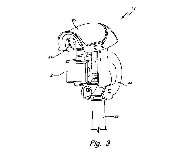
FIG. 3 is a perspective view of an embodiment of the hybrid sensor
assembly 34 of the traffic sensing system 32. A first sensor 40 can be a radar
(e.g.,
Doppler radar), and a second sensor 42 can be a machine vision device (e.g.,
charge-
coupled device). The first sensor 40 can be located below the second sensor,
with both
sensors 40 and 42 generally facing the same direction. The hardware should
have a robust
mechanical design that meets National Electrical Manufacturers Association
(NEMA)
environmental requirements. In one embodiment, the first sensor 40 can be an
Universal
Medium Range Resolution (UMRR) radar, and the second sensor 42 can be a
visible light
camera which is capable of recording images in a video stream composed of a
series of
image frames. A support mechanism 44 commonly supports the first and second
sensors
40 and 42 on the support structure 36, while allowing for sensor adjustment
(e.g.,
adjustment of pan/yaw, tilt/elevation, etc.). Adjustment of the support
mechanism allows
for simultaneous adjustment of the position of both the first and second
sensors 40 and 42.
Such simultaneous adjustment facilitates installation and set-up where the
azimuth angles
01 and 02 of the first and second sensors 40 and 42 are substantially the
same. For instance,
where the first sensor 40 is a radar, the orientation of the field of view of
the second sensor
42 simply through manual sighting along a protective covering 46 can be used
to simplify
aiming of the radar due to mechanical relationships between the sensors. In
some
embodiments, the first and the second sensors 40 and 42 can also permit
adjustment
relative to one another (e.g., rotation, etc.). Independent sensor adjustment
may be
desirable where the azimuth angles 01 and 02 of the first and second sensors
40 and 42 are
desired to be significantly different. The protective covering 46 can be
provided to help
protect and shield the first and second sensors 40 and 42 from environmental
conditions,
such as sun, rain, snow and ice. Tilt of the first sensor 40 can be
constrained to a given
6
CA 02803404 2012-12-19
WO 2012/068064 PCT/US2011/060726
range to minimize protrusion from a lower back shroud and field of view
obstruction by
other portions of the assembly 34.
FIG. 4A is a schematic block diagram of an embodiment of the hybrid
sensor assembly 34 and associated circuitry. In the illustrated embodiment,
the first sensor
40 is a radar (e.g., Doppler radar) and includes one or more antennae 50, and
analog-to-
digital (A/D) converter 52, and a digital signal processor (DSP) 54. Output
from the
antenna(e) 50 is sent to the A/D converter 52, which sends a digital signal to
the DSP 54.
The DSP 54 communicates with a processor (CPU) 56, which is connected to an
input/output (1/0) mechanism 58 to allow the first sensor 40 to communicate
with external
components. The 1/0 mechanism can be a port for a hard-wired connection, and
alternatively (or in addition) can provide for wireless communication.
Furthermore, in the illustrated embodiment, the second sensor 42 is a
machine vision device and includes a vision sensor (e.g., CCD or CMOS array)
60, an
A/D converter 62, and a DSP 64. Output from the vision sensor 60 is sent to
the A/D
converter 62, which sends a digital signal to the DSP 64. The DSP 64
communicates with
the processor (CPU) 56, which in turn is connected to the 1/0 mechanism 58.
FIG. 4B is a schematic block diagram of another embodiment of a hybrid
sensor assembly 34. As shown in FIG. 4B, the A/D converters 52 and 62, DSPs 54
and
64, and CPU 56 are all integrated into the same physical unit as the sensors
40 and 42, in
contrast to the embodiment of FIG. 4A where the A/D converters 52 and 62, DSPs
54 and
64, and CPU 56 can be located remote from the hybrid sensor assembly 34 in a
separate
enclosure.
Internal sensor algorithms can be the same or similar to those for known
traffic sensors, with any desired modifications of additions, such as queue
detection and
turning movement detection algorithms that can be implemented with a hybrid
detection
module (HDM) described further below.
It should be noted that the embodiment illustrated in FIG. 4 is shown
merely by way of example, and not limitation. In further embodiments, other
types of
sensors can be utilized, such as LIDAR, etc. Moreover, more than two sensors
can be
used, as desired for particular applications.
In a typical installation, the hybrid sensor assembly 34 is operatively
connected to additional components, such as one or more controller or
interfaces boxes
and a traffic controller (e.g., traffic signal system). FIG. 5A is a schematic
block diagram
of one embodiment of the traffic sensing system 32, which includes four hybrid
sensor
7
CA 02803404 2012-12-19
WO 2012/068064 PCT/US2011/060726
assemblies 34A-34D, a bus 72, a hybrid interface panel box 74, and a hybrid
traffic
detection system box 76. The bus 72 is operatively connected to each of the
hybrid sensor
assemblies 34A-34D, and allows transmission of power, video and data. Also
connected
to the bus 72 is the hybrid interface panel box 74. A zoom controller box 78
and a display
80 are connected to the hybrid interface panel box 74 in the illustrated
embodiment. The
zoom controller box 78 allows for control of zoom of machine vision sensors of
the hybrid
sensor assemblies 34A-34D. The display 80 allows for viewing of video output
(e.g.,
analog video output). A power supply 82 is further connected to the hybrid
interface panel
box 74, and a terminal 84 (e.g., laptop computer) can be interfaced with the
hybrid
interface panel box 74. The hybrid interface panel box 74 can accept 110/220
VAC power
and provides 24 VDC power to the sensor assemblies 34A-34D. Key functions of
the
hybrid interface panel box 74 are to deliver power to the hybrid sensor
assemblies 34A-
34D and to manage communications between the hybrid sensor assemblies 34A-34D
and
other components like the hybrid traffic detection system box 76. The hybrid
interface
panel box 74 can include suitable circuitry, processors, computer-readable
memory, etc. to
accomplish those tasks and to run applicable software. The terminal 84 allows
an operator
or technician to access and interface with the hybrid interface panel box 74
and the hybrid
sensor assemblies 34A-34D to perform set-up, configuration, adjustment,
maintenance,
monitoring and other similar tasks. A suitable operating system, such as
WINDOWS from
Microsoft Corporation, Redmond, WA, can be used with the terminal 84. The
terminal 84
can be located at the roadway intersection 30, or can be located remotely from
the
roadway 30 and connected to the hybrid interface panel box 74 by a suitable
connection,
such as via Ethernet, a private network or other suitable communication link.
The hybrid
traffic detection system box 76 in the illustrated embodiment is further
connected to a
traffic controller 86, such as a traffic signal system that can be used to
control traffic at the
intersection 30. The hybrid detection system box 76 can include suitable
circuitry,
processors, computer-readable memory, etc. to run applicable software, which
is discussed
further below. In some embodiments, the hybrid detection system box 76
includes one or
more hot-swappable circuitry cards, with each card providing processing
support for a
given one of the hybrid sensor assemblies 34A-34D. In further embodiments, the
traffic
controller 86 can be omitted. One or more additional sensors 87 can optionally
be
provided, such as a rain/humidity sensor, or can be omitted in other
embodiments. It
should be noted that the illustrated embodiment of FIG. 5A is shown merely by
way of
example. Alternative implementations are possible, such as with further bus
integration or
8
CA 02803404 2012-12-19
WO 2012/068064 PCT/US2011/060726
with additional components not specifically shown. For example, an Internet
connection
that enables access to third-party data, such as weather information, etc.,
can be provided.
FIG. 5B is a schematic block diagram of another embodiment of the traffic
sensing system 32'. The embodiment of system 32' shown in FIG. 5B is generally
similar
to that of system 32 shown in FIG. 5A; however, the system 32' includes an
integrated
control system box 88 that provides functions of both the hybrid interface
panel box 74
and the hybrid traffic detection system box 76. The integrated control system
box 88 can
be located at or in close proximity to the hybrid sensors 34, with only
minimal interface
circuitry on the ground to plumb detection signals to the traffic controller
86. Integrating
multiple control boxes together can facilitate installation.
FIG. 6 is a schematic block diagram of software subsystems of the traffic
sensing system 32 or 32'. For each n hybrid sensor assemblies, a hybrid
detection module
(HDM) 90-1 to 90-n is provided that includes a hybrid detection state machine
(HDSM)
92, a radar subsystem 94, a video subsystem 96 and a state block 98. In
general, each
HDM 90-1 to 90-n correlates, synchronizes and evaluates the detection results
from the
first and second sensors 40 and 42, but also contains decision logic to
discern what is
happening in the scene (e.g., intersection 30) when the two sensors 40 and 42
(and
subsystems 94 and 96) offer conflicting assessments. With the exception of
certain
Master-Slave functionality, each HDM 90-1 to 90-n generally operates
independently of
the others, thereby providing a scalable, modular system. The hybrid detection
state
machine 92 of the HDMs 90-1 to 90-n further can combine detection outputs from
the
radar and video subsystems 94 and 96 together. The HDMs 90-1 to 90-n can add
data
from the radar subsystem 94 onto a video overlay from the video subsystem 96,
which can
be digitally streamed to the terminal 84 or displayed on the display 80 in
analog for
viewing. While the illustrated embodiment is described with respect to radar
and
video/camera (machine vision) sensors, it should be understood that other
types of sensors
can be utilized in alternative embodiments. The software of the system 32 or
32' further
includes a communication server (comserver) 100 that manages communication
between
each of the HDMs 90-1 to 90-n and a hybrid graphical user interface (GUI) 102,
a
configuration wizard 104 and a detector editor 106. HDM 90-1 to 90-n software
can run
independent of GUI 102 software once configured, and incorporates
communication from
the GUI 102, the radar subsystem 94, the video subsystem 96 as well as the
HDSM 92.
HDM 90-1 to 90-n software can be implemented on respective hardware cards
provided in
9
CA 02803404 2012-12-19
WO 2012/068064 PCT/US2011/060726
the hybrid traffic detection system box 76 of the system 32 or the integrated
control
system box 88 of the system 32'.
The radar and video subsystems 94 and 96 process and control the
collection of sensor data, and transmit outputs to the HDSM 92. The video
subsystem 96
(utilizing appropriate processor(s) or other hardware) can analyze video or
other image
data to provide a set of detector outputs, according to the user's detector
configuration
created using the detector editor 106 and saved as a detector file. This
detector file is then
executed to process the input video and generate output data which is then
transferred to
the associated HDM 90-1 to 90-n for processing and final detection selection.
Some
detectors, such as queue size detector and detection of turning movements, may
require
additional sensor information (e.g., radar data) and thus can be implemented
in the HDM
90-1 to 90-n where such additional data is available.
The radar subsystem 94 can provide data to the associated HDMs 90-1 to
90-n in the form of object lists, which provide speed, position, and size of
all objects
(vehicles, pedestrians, etc.) sensed/tracked. Typically, the radar has no
ability to configure
and run machine vision-style detectors, so the detector logic must generally
be
implemented in the HDMs 90-1 to 90-n. Radar-based detector logic in the HDMs
90-1 to
90-n can normalize sensed/tracked objects to the same spatial coordinate
system as other
sensors, such as machine vision devices. The system 32 or 32' can use the
normalized
object data, along with detector boundaries obtained from a machine vision (or
other)
detector file to generate detector outputs analogous to what a machine vision
system
provides.
The state block 98 provides indication and output relative to the state of the
traffic controller 86, such as to indicate if a given traffic signal is
"green", "red", etc.
The hybrid GUI 102 allows an operator to interact with the system 32 or
32', and provides a computer interface, such as for sensor normalization,
detection domain
setting, and data streaming and collection to enable performance visualization
and
evaluation. The configuration wizard 104 can include features for initial set-
up of the
system and related functions. The detector editor 106 allows for configuration
of
detection zones and related detection management functions. The GUI 102,
configuration
wizard 104 and detector editor 106 can be accessible via the terminal 84 or a
similar
computer operatively connected to the system 32. It should be noted that while
various
software modules and components have been described separately, it should be
noted that
these functions can be integrated into a single program or software suite, or
provided as
CA 02803404 2012-12-19
WO 2012/068064 PCT/US2011/060726
separate stand-alone packages. The disclosed functions can be implemented via
any
suitable software in further embodiments.
The GUI 102 software can run on a Windows PC, Apple PC or Linux PC,
or other suitable computing device with a suitable operating system, and can
utilize
Ethernet or other suitable communication protocols to communicate with the
HDMs 90-1
to 90-n. The GUI 102 provides a mechanism for setting up the HDMs 90-1 to 90-
n,
including the video and the radar subsystems 94 and 96 to: (1) normalize/align
fields of
view from both the first and second sensors 40 and 42; (2) configure
parameters for the
HDSM 92 to combine video and radar data; (3) enable visual evaluation of
detection
performance (overlay on video display); and (4) allow collection of data, both
standard
detection output and development data. A hybrid video player of the GUI 102
will allow
users to overlay radar-tracking markers (or markers from any other sensing
modality) onto
video from a machine vision sensor (see FIGS. 11B and 14). These tracking
markers can
show regions where the radar is currently detecting vehicles. This video
overlay is useful
to verify that the radar is properly configured, as well as to enable users to
easily evaluate
the radar's performance in real-time. The hybrid video player of the GUI 102
can allow a
user to select from multiple display modes, such as: (1) Hybrid - shows
current state of
the detectors determined from hybrid decision logic using both the machine
vision and
radar sensor inputs; (2) Video/Vision - shows current state of the detectors
using only
machine vision input; (3) Radar - shows current state of the detectors using
only radar
sensor input; and/or (4) Video/Radar Comparison - provides a simple way to
visually
compare the performance of machine vision and radar, using a multi-color
scheme (e.g.,
black, blue, red and green) to show all of the permutations of when the two
devices agree
and disagree for a given detection zone. In some embodiments, only some of the
display
modes described above can be made available to users.
The GUI 102 communicates with the HDMs 90-1 to 90-n via an API,
namely additions to a client application programming interface (CLAPI), which
can go
through the comserver 100, and eventually to the HDMs 90-1 to 90-n. An
applicable
communications protocol can send and receive normalization information,
detector output
definitions, configuration data, and other information to support the GUI 102.
Functionality for interpreting, analyzing and making final detections or
other such functions of the system are primarily performed by the hybrid
detection state
machine 92. The HDSM 92 can take outputs from detectors, such as machine
vision
detectors and radar-based detectors, and arbitrates between them to make final
detection
11
CA 02803404 2012-12-19
WO 2012/068064 PCT/US2011/060726
decisions. For radar data, the HDSM 92 can, for instance, retrieve speed, size
and polar
coordinates of target objects (e.g., vehicles) as well as Cartesian
coordinates of tracked
objects, from the radar subsystem 94 and the corresponding radar sensors 40-1
to 40-n.
For machine vision, the HDSM 92 can retrieve data from the detection state
block 98 and
from the video subsystem 96 and the associated video sensors (e.g., camera) 42-
1 to 42-n.
Video data is available at the end of every video frame processed. The HDSM 92
can
contain and perform sensor algorithm data switching/fusion/decision logic/etc.
to process
radar and machine vision data. A state machine to determine which detection
outcomes
can be used, based on input from the radar and machine vision data and post-
algorithm
decision logic. Priority can be given to the sensor believed to be most
accurate for the
current conditions (time of day, weather, video contrast level, traffic level,
sensor
mounting position, etc.).
The state block 98 can provide final, unified detector outputs to a bus or
directly to the traffic controller 86 through suitable ports (or wirelessly).
Polling at regular
intervals can be used to provide these detector outputs from the state block
98. Also, the
state block can provide indications of each signal phase (e.g., red, green) of
the signal
controller 86 as an input.
Numerous types of detection can be employed. Presence or stop-line
detectors identify the presence of a vehicle in the field of view (e.g., at
the stop line or stop
bar); their high accuracy in determining the presence of vehicles makes them
ideal for
signal-controlled intersection applications. Count and speed detection (which
includes
vehicle length and classification) for vehicles passing along the roadway.
Crosslane count
detectors provide the capability to detect the gaps between vehicles, to aid
in accurate
counting. The count detectors and speed detectors work in tandem to perform
vehicle
detection processing (that is, the detectors show whether or not there is a
vehicle under the
detector and calculate its speed). Secondary detector stations compile traffic
volume
statistics. Volume is the sum of the vehicles detected during a time interval
specified.
Vehicle speeds can be reported either in km/hr or mi/hr. and can be reported
as an integer.
Vehicle lengths can be reported in meters or feet. Advanced detection can be
provided for
the dilemma zone (primarily focusing on presence detection, speed,
acceleration and
deceleration). The "dilemma zone" is the zone in which drivers must decide to
proceed or
stop as the traffic control (i.e., traffic signal light) changes from green to
amber and then
red. Turning movement counts can be provided, with secondary detector stations
connected to primary detectors to compile traffic volume statistics. Volume is
the sum of
12
CA 02803404 2012-12-19
WO 2012/068064 PCT/US2011/060726
the vehicles detected during a time interval specified. Turning movement
counts are
simply counts of vehicles making turns at the intersection (not proceeding
straight through
the intersection). Specifically, left turning counts and right turning counts
can be provided
separately. Often, traffic in the same lane may either proceed straight
through or turn and
this dual lane capability must be taken into account. Queue size measurement
can also be
provided. The queue size can be defined as the objects stopped or moving below
a user-
defined speed (e.g., a default 5 mi/hr threshold) at the intersection
approach; thus, the
queue size can be the number of vehicles in the queue. Alternately, the queue
size can be
measured from the stop bar to the end of the upstream queue or end of the
furthest
detection zone, whichever is shortest. Vehicles can be detected as they
approach and enter
the queue, with continuous accounting of the number of vehicles in the region
defined by
the stop line extending to the back of the queue tail.
Handling of errors is also provided, including handling of communication,
software errors and hardware errors. Regarding potential communication errors,
outputs
can be set to place a call to fail safe in the following conditions: (i) for
failure of
communications between hardware circuitry and the associated radar sensors
(e.g., first
sensors 40) and only outputs associated with that radar sensor, the machine
vision outputs
(e.g., second sensors 42) can be used instead, if operating properly; (ii) for
loss of a
machine vision output and only outputs associated with that machine vision
sensor; and
(iii) for loss of detector port communications-associated outputs will be
placed into call
or fail safe for the slave unit whose communications is lost. A call is
generally an output
(e.g., to the traffic controller 86) based on a detection (i.e., a given
detector triggered
"on"), and a fail-safe call can default to a state that corresponds to a
detection, which
generally reduces the likelihood of a driver being "stranded" at an
intersection because of
a lack of detection. Regarding potential software errors, outputs can be set
to place call to
fail safe if the HDM software 90-1 to 90-n is not operational. Regarding
potential
hardware errors, selected outputs can be set to place call (sink current), or
fail safe, in the
following conditions: (i) loss of power, all outputs; (ii) failure of control
circuitry, all
outputs; and (iii) failure of any sensors of the sensor assemblies 34A-34D,
only outputs
associated with failed sensors.
Although the makeup of software for the traffic sensing system 32 or 32'
has been described above, it should be understood that various other features
not
specifically discussed can be incorporated as desired for particular
applications. For
example, known features of the Autoscope system and RTMS system, both
available
13
CA 02803404 2012-12-19
WO 2012/068064 PCT/US2011/060726
from Image Sensing Systems, Inc., St. Paul, MN, can be incorporated. For
instance, such
known functionality can include: (a) a health monitor - monitors the system to
ensure
everything is running properly; (b) a logging system - logs all significant
events for
troubleshooting and servicing; (c) detector port messages - for use when
attaching a
device (slave) for communication with another device (master); detector
processing of
algorithms - for processing the video images and radar outputs to enable
detection and
data collection; (d) video streaming - for allowing the user to see an output
video feed; (e)
writing to non-volatile memory - allows a module to write and read internal
non-volatile
memory containing a boot loader, operational software, plus additional memory
that
system devices can write to for data storage; (f) protocol messaging -
message/protocol
from outside systems to enable communication with the traffic sensing system
32 or 32';
(g) a state block - contains the state of the 1/0; and (h) data collection -
for recording 1/0,
traffic data, and alarm states.
Now that basic components of the traffic sensing system 32 and 32' have
been described, a method of installing and normalizing the system can be
discussed.
Normalization of overlapping sensor fields of view of a hybrid system is
important so that
data obtained from different sensors, especially those using different sensing
modalities,
can be correlated and used in conjunction or interchangeably. Without suitable
normalization, use of data from different sensors would produce detections in
disparate
coordinate systems preventing a unified system detection capability.
FIG. 7 is a flow chart illustrating an installation and normalization method
for use with the system 32 and 32'. Initially, hardware and associated
software are
installed at location where traffic sensing is desired, such as the roadway
intersection 30
(step 100). Installation includes physically installing all sensor assemblies
34 (the number
of assemblies provided will vary for particular applications), installing
control boxes 74,
76 and/or 88, making wired and/or wireless connections between components, and
aiming
the sensor assemblies 34 to provide desired fields of view (see FIGS. 2 and
8). The
sensor assemblies 34 can be mounted to any suitable support structure 36, and
the
particular mounting configuration will vary as desired for particular
applications. Aiming
the sensor assemblies 34 an include pan/yaw (left or right), elevation/tilt
(up or down),
camera barrel rotation (clockwise or counterclockwise), sunshield/covering
overhang, and
zoom adjustments. Once physically installed, relevant physical positions can
be measured
(step 102). Physical measurements can be taken manually by a technician, such
as height
H of the sensor assemblies 34, and distances D1, Ds, DA, DR, DLi to DL2,
described above
14
CA 02803404 2012-12-19
WO 2012/068064 PCT/US2011/060726
with respect to FIG. 1. These measurements can be used to determine sensor
orientation,
help normalize and calibrate the system and establish sensing and detection
parameters. In
one embodiment, only sensor height H and distance to the stop bar Ds
measurements are
taken.
After physical positions have been measured, orientations of the sensor
assemblies 34 and the associated first and second sensors 40 and 42 can be
determined
(step 104). This orientation determination can include configuration of
azimuth angles 0,
elevation angles 0, and rotation angle. The azimuth angle 0 for each discrete
sensor 40
and 42 of a given hybrid sensor assembly 34 can be a dependent degree of
freedom, i.e.,
azimuth angles 01 and 02 are identical for the first and second sensors 40 and
42, given the
mechanical linkage in the preferred embodiment. The second sensor 42 (e.g.,
machine
vision device) can be configured such that a center of the stop-line for the
traffic approach
38 substantially aligns with a center of the associated field of view 34-1.
Given the
mechanical connection between the first and second sensors 40 and 42 in a
preferred
embodiment, one then knows that alignment of the first sensor 40 (e.g., a bore
sight of a
radar) has been properly set. The elevation angle 0 for each sensor 40 and 42
is an
independent degree of freedom for the hybrid sensor assembly 34, meaning the
elevation
angle (31 of the first sensor 40 (e.g., radar) can be adjusted independently
of the elevation
angle (32 of the second sensor 42 (e.g., machine vision device).
Once sensor orientation is known, the coordinates of that sensor can be
rotated by the azimuth angle 0 so that axes align substantially parallel and
perpendicular to
a traffic direction of the approach 38. Adjustment can be made according to
the following
equations (1) and (2), where sensor data is provided in x, y Cartesian
coordinates:
x' = cos(0) * x - sin(0) * y (1)
y' = sin(0) * x + cos(0) * y (2)
Also a second transformation can be used to harmonize axis-labeling
conventions of the first and second sensors 40 and 42, according to equations
(3) and (4):
x"=-y' (3)
y" = x' (4)
A normalization application (e.g., the GUI 102 and/or the configuration
wizard 104) can then be opened to begin field of view normalization for the
first and
second sensors 40 and 42 of each hybrid sensor assembly 34 (step 106). With
the
normalization application open, objects are positioned on or near the roadway
of interest
(e.g., roadway intersection 30) in a common field of view of at least two
sensors of a given
CA 02803404 2012-12-19
WO 2012/068064 PCT/US2011/060726
hybrid sensor assembly 34 (step 108). In one embodiment, the objects can be
synthetic
target generators, which, generally speaking, are objects or devices capable
of generating a
recordable sensor signal. For example, in one embodiment a synthetic target
generator can
be a Doppler generator that can generate a radar signature (Doppler effect)
while
stationary along the roadway 30 (i.e., not moving over the roadway 30). In an
alternative
embodiment using an infrared (IR) sensor, synthetic target generator can be a
heating
element. Multiple objects can be positioned simultaneously, or alternatively
one or more
objects can be sequentially positioned, as desired. The objects can be
positioned on the
roadway in a path of traffic or on a sidewalk, boulevard, curtilage or other
adjacent area.
Generally at least three objects are positioned in a non-collinear
arrangement. In
applications where the hybrid sensor assembly 34 includes three or more
discrete sensors,
the objects can be positioned in an overlapping field of view of all of the
discrete sensors,
or of only a subset of the sensors at a given time, though eventually an
objects should be
positioned within the field of view of each of the sensors of the assembly 34.
Objects can
be temporarily held in place manually by an operator, or can be self-
supporting without
operator presence. In still further embodiments, the objects can be existing
objects
positioned at the roadway 30, such as posts, mailboxes, buildings, etc.
With the object(s) positioned, data is recorded for multiple sensors of the
hybrid sensor assembly 34 being normalized, to capture data that includes the
positioned
objects in the overlapping field of view, that is, multiple sensors sense the
object(s) on the
roadway within the overlapping fields of view (step 110). This process can
involve
simultaneous sensing of multiple objects, or sequential recording of one or
more objects in
different locations (assuming no intervening adjustment or repositioning of
the sensors of
the hybrid sensor assembly 34 being normalized). After data is captured, an
operator can
use the GUI 102 to select one or more frames of data recorded from the second
sensor 42
(e.g., machine vision device) of the hybrid sensor assembly 34 being
normalized that
provide at least three non-collinear points that correspond to the locations
of the positioned
objects in the overlapping field of view of the roadway 30, and selects those
points in the
one or more selected frames to identify the objects' locations in a coordinate
system for
the second sensor 42 (step 112). Selecting the points in the frame(s) from the
second
sensor 42 can be done manually, through a visual assessment by the operator
and actuation
of an input device (e.g., mouse-click, touch screen contact, etc.) to
designate the location
of the objects in the frame(s). In an alternate embodiment, a distinctive
visual marking
can be provided to attached to the object(s) and the GUI 102 can automatically
or semi-
16
CA 02803404 2012-12-19
WO 2012/068064 PCT/US2011/060726
automatically search through frames to identify and select the location of the
markers and
therefore also the object(s). The system 32 or 32' can record the selection in
the
coordinate system associated with second sensor 42, such as pixel location for
output of a
machine vision device. The system 32 or 32' can also perform an automatic
recognition
of the objects relative to another coordinate system associated with the first
sensor 40,
such as in polar coordinates for output of a radar. The operator can select
the coordinates
of the coordinate system of the first sensor 40 from an object list (due to
the possibility
that other objects may be sensed on the roadway 30 in addition to the
object(s)), or
alternatively automated filtering could be performed to select the appropriate
coordinates.
The selected coordinates of the first sensor 40 can be adjusted (e.g.,
rotated) in accordance
with the orientation determination of step 104 described above. The location
selection
process can be repeated for all applicable sensors of a given hybrid sensor
assembly 34
until locations of the same object(s) have been selected in the respective
coordinate
systems for each of the sensors.
After points corresponding to the locations of the objects have been
selected in each sensor coordinate system, those points are translated or
correlated to
common coordinates used to normalize and configure the traffic sensing system
32 or 32'
(step 114). For instance, radar polar coordinates can be mapped, translated or
correlated to
pixel coordinates of a machine vision device. In this way, a correlation
between data of all
of the sensors of a given hybrid sensor assembly 34, so that objections in a
common,
overlapping field of view of those sensors can be identified in a common
coordinate
system, or alternatively in a primary coordinate system and mapped into any
other
correlated coordinate systems for other sensors. In one embodiment, all
sensors can be
correlated to a common pixel coordinate system.
Next, a verification process can be performed, through operation of the
system 32 or 32' and observation of moving objects traveling through the
common,
overlapping field of view of the sensors of the hybrid sensor assembly 34
being
normalized (step 116). This is a check on the normalization already performed,
and an
operator can adjust or clear and perform again the previous steps to obtain a
more desired
normalization.
After normalization of the sensor assembly 34, an operator can use the GUI
102 to identify one or more lanes of traffic for one or more approaches 38 on
the roadway
30 in the common coordinate system (or in one coordinate system correlated to
other
coordinate systems) (step 118). Lane identification can be performed manually
by an
17
CA 02803404 2012-12-19
WO 2012/068064 PCT/US2011/060726
operator drawing lane boundaries on a display of sensor data (e.g., using a
machine vision
frame or frames depicting the roadway 30). Physical measurements (from step
102) can
be used to assist the identification of lanes. In alternative embodiments
automated
methods can be used to identify and/or adjust lane identifications.
Additionally, an operator can use the GUI 102 and/or the detection editor
106 to establish one or more detection zones (step 120). The operator can draw
the
detection zones on a display of the roadway 30. Physical measurements (from
step 102)
can be used to assist the establishment of detection zones.
The method illustrated in FIG. 7 is shown merely by way of example.
Those of ordinary skill in the art will appreciate that the method can be
performed in
conjunction with other steps not specifically shown or discussed above.
Moreover, the
order of particular steps can vary, or can be performed simultaneously, in
further
embodiments. Further details of the method shown in FIG. 7 will be better
understood in
relation to additional figures described below.
FIG. 8 is an elevation view of a portion of the roadway intersection 30,
illustrating an embodiment of the hybrid sensor assembly 34 in which the first
sensor 40 is
a radar. In the illustrated embodiment, the first sensor 40 is aimed such that
its field of
view 34-1 extends in front of a stop bar 130. For example, for a stop-bar
positioned
approximately 30 m from the hybrid sensor assembly 34 (i.e., Ds = 30 m), the
elevation
angle (3i for the radar (e.g., the first sensor 40) is set such that 10 dB off
a main lobe aligns
approximately with the stop-bar 130. FIG. 8 illustrates this concept for a
luminaire
installation (i.e., where the support structure 36 is a luminaire). The radar
is configured
such that a 10 dB point off the main lobe intersects with the roadway 30
approximately 5
m in front of the stop-line. Half of the elevation width of the radar beam is
then subtracted
to obtain an elevation orientation value usable by the traffic sensing system
32 or 32'.
FIG. 9 is a view of a normalization display interface 140 of the GUI 102 for
establishing coordinate system correlation between multiple sensor inputs from
a given
hybrid sensor assembly 34. In the illustrated embodiment, six objects 142A-
142F are
positioned in the roadway 30. In some embodiments it may be desirable to
position the
objects 142A-142F in meaningful locations on the roadway 30, such as along
lane
boundaries, along the stop bar 130, etc. Meaningful locations will generally
corresponding to the type of detection(s) desired for a given application.
Alternatively, the
objects 142A-142F can be positioned outside of the approach 38, such as on a
median or
18
CA 02803404 2012-12-19
WO 2012/068064 PCT/US2011/060726
boulevard strip, sidewalk, etc., to reduce obstruction of traffic on the
approach 38 during
normalization.
The objects 142A-142F can each be synthetic target generators (e.g.,
Doppler generators, etc.). In general, synthetic target generators are objects
or devices
capable of generating a recordable sensor signal, such as a radar signature
(Doppler effect)
generated while the object is stationary along the roadway 30 (i.e., not
moving over the
roadway 30). In this way, a stationary object on the roadway 30 can given the
appearance
of being a moving object that can be sensed and detected by a radar. For
instance,
mechanical and electrical Doppler generators are known, and any suitable
Doppler
generator can be used with the present invention as a synthetic target
generator for
embodiments utilizing a radar sensor. A mechanical or electro-mechanical
Doppler
generator can include a spinning fan in a slit enclosure having a slit. An
electrical Doppler
generator can include a transmitter to transmit an electromagnetic wave to
emulate a radar
return signal (i.e., emulating a reflected radar wave) from a moving object at
a suitable or
desired speed. Although a typical radar cannot normally detect stationary
objects, a
synthetic target generator like a Doppler generator makes such detection
possible. For
normalization as described above with respect to FIG. 7, stationary objects
are much more
convenient than moving objects. Alternatively, the objects 142A-142F can be
objects that
move or are moved relative to the roadway 30, such as corner reflectors that
halp provide
radar reflection signatures.
Although six objects 142A-142F are shown in FIG. 9, only a minimum of
three non-collinearly positioned objects need to be positioned in other
embodiments.
Moreover, as noted above, not all of the objects 142A-142F need to be
positioned
simultaneously.
FIG. 10 is a view of a normalization display 146 for establishing traffic
lanes using machine vision data (e.g., from the second sensor 42). Lane
boundary lines
148-1, 148-2 and 148-3 can be manually drawn over a display of sensor data,
using the
GUI 102. A stop line boundary 148-4 and a boundary of a region of interest 148-
5 can
also be drawn over a display of sensor data by an operator. Moreover, although
the
illustrated embodiment depicts an embodiment with linear boundaries, non-
linear
boundaries can be provided for different roadway geometries. Drawing boundary
lines as
shown in FIG. 10 can be performed after a correlation between sensor
coordinate systems
has been established, allowing the boundary lines drawn with respect to one
coordinate
19
CA 02803404 2012-12-19
WO 2012/068064 PCT/US2011/060726
system to be mapped or correlated to another or universal coordinate system
(e.g., in an
automatic fashion).
As an alternative to having an operator manually draw the stop line
boundary 148-4, an automatic or semi-automatic process can be used in further
embodiments. The stop line position is usually difficult to find, because
there is only one
somewhat noisy indicator: where objects (e.g., vehicles) stop. Objects are not
guaranteed
to stop exactly on the stop line (as designated on the roadway 30 by paint,
etc.); they could
stop up to several meters ahead or behind the designated stop line on the
roadway 30.
Also, some sensing modalities, such as radar, can have significant errors in
estimating
positions of stopped vehicles. Thus, an error of +/- several meters can be
expected in a
stop line estimate. The stop line position can be found automatically or semi-
automatically by averaging a position (e.g., a y-axis position) of a nearest
stopped object
in each measurement/sensing cycle. Taking only the nearest stopped objects
helps
eliminate undesired skew caused by non-front objects in queues (i.e., second,
third, etc.
vehicles in a queue). This dataset will have some outliers, which can be
removed using an
iterative process (similar to one that can be used in azimuth angle
estimates):
(a) Take a middle 50% of samples nearest a stop line position estimate
(inliers), and discard the other 50% of points (outliers). An initial stop
line position
estimate can be an operator's best guess, informed by any available physical
measurements, geographic information system (GIS) data, etc.
(b) Determine a mean (average) of the inliers, and consider this mean the
new stop line position estimate.
(c) Repeat steps (a) and (b) until method converges (e.g., 0.0001 delta
between steps (a) and (b)) a threshold number of iterations of steps (a) and
(b) have been
reached (e.g., 100 iterations). Typically, method should converge within
around 10
iterations. After convergence or reaching the iteration threshold, a final
estimate of this
the stop line boundary position is obtained. A small offset can be applied, as
desired.
It is generally necessary to provide orientation information to the system 32
or 32' to allow suitable recognition of the orientation of the sensors of the
hybrid sensor
assembly 34 relative to the roadway 30 desired to be sensed. Two possible
methods for
determining orientation angles are illustrated in FIGS. 11A, 11B and 11C. FIG.
11A is a
view of a normalization display 150 for one form of sensor orientation
detection and
normalization. As shown in the illustrated embodiment of FIG. 11A, a radar
output (e.g.,
of the first sensor 40) is provided in a first field of view 34-1 for four
lanes of traffic Li to
CA 02803404 2012-12-19
WO 2012/068064 PCT/US2011/060726
L4 of the roadway 30. Numerous objects 152 (e.g., vehicles) are detected in
the field of
view 34-1, and a movement vector 152-1 is provided for each detected object.
It should
be noted that it is well-known for radar sensor systems to provide vector
outputs for
detected moving objects. By viewing the display 150 (e.g., with the GUI 102),
an operator
can adjust an orientation of the first sensor 40 recognized by the system 32
or 32' such that
vectors 152-1 substantially align with the lanes of traffic Li to L4. Lines
designating lanes
of traffic Ll to L4 can be manually drawn by an operator (see FIG. 10). This
approach
assumes that sensed objects travel substantially parallel to lanes of the
roadway 30.
Operator skill can account for any outliers or artifacts in data used for this
process.
FIG. 11B is a view of another normalization display 150' for another form
of sensor orientation detection and normalization. In the embodiment
illustrated in FIG.
11B, the display 150' is a video overlay of image data from the second sensor
42 (e.g.,
machine vision device) with bounding boxes 154-1 of objects detected with the
first sensor
40 (e.g., radar). An operator can view the display 150' to assess and adjust
alignment
between the bounding boxes 154-1 and depictions of objects 154-2 visible on
the display
150'. Operator skill can be used to address any outliers or artifacts in data
used for this
process.
FIG. 11C is a view of yet another normalization display 150" for another
form of sensor orientation detection and normalization. In the embodiment
illustrated in
FIG. 11C, an automated or semi-automated procedure allows sensor orientation
determination and normalization. The procedure can proceed as follows. First,
sensor
data of vehicle traffic is recorded for a given period of time (e.g., 10-20
minutes), and
saved. An operator then opens the display 150" (e.g., part of the GUI 102),
and accesses
the saved sensor data. The operator enters an initial normalization guess in
block 156 for a
given sensor (e.g., the first sensor 40, which can be a radar), which can
include a guess as
to azimuth angle 0, stop line position and lane boundaries. These guesses can
be informed
by physical measurements, or alternatively using engineering/technical
drawings or
distance measurement tools of electronic GIS tools, such as GOOGLE MAPS,
available
from Google, Inc., Mountain View, CA, or BING MAPS, available from Microsoft
Corp.
The azimuth angle 0 guess can match the applicable sensor's setting at the
time of the
recording. The operator can then request that the system take the recorded
data and the
initial guesses and compute the most likely normalization. Results can be
shown and
visually displayed, with object tracks 158-1, lane boundaries 158-2, stop line
158-3, the
sensor position 158-4 (located at origin of distance graph) and field of view
158-5. The
21
CA 02803404 2012-12-19
WO 2012/068064 PCT/US2011/060726
operator can visually assess the automatic normalization, and can make any
desired
changes in the results block 159, which refreshing of the plot after
adjustment. This
feature allows manual fine-tuning of the automated results.
Steps of the auto-normalization algorithm can be as described in the
following embodiment. The azimuth angle 0 is estimated first. Once the azimuth
angle 0
is known, the object coordinates for the associated sensor (e.g., the first
sensor 40) can be
rotated so that axes of the associated coordinate system align parallel and
perpendicular to
the traffic direction. This azimuth angle 0 simplifies estimation of the stop
line and lane
boundaries. Next, the sensor coordinates can be rotated as a function of the
azimuth angle
0 the user entered as an initial guess. The azimuth angle 0 is computed by
finding an
average direction of travel of the objects (e.g., vehicles) in the sensor's
field of view. It is
assumed that on average objects will travel parallel to lane lines. Of course,
vehicles
executing turning maneuvers or changing lanes will violate this assumption.
Those types
of vehicles produce outliers in the sample set that must be removed. Several
different
methods are employed to filter outliers. As an initial filter, all objects
with speed less than
a given threshold (e.g., approximately 24 km/hr or 15 mi/hr) can be removed.
Those
objects are considered more likely to be turning vehicles or otherwise not
traveling parallel
to lane lines. Also, any objects with a distance outside of approximately 5 to
35 meters
past the stop line are removed; objects in this middle zone are considered the
most reliable
candidates to be accurately tracked while travelling within the lanes of the
roadway 30.
Because the stop line location is not yet known, the operator's guess can be
used at this
point. Now using this filtered dataset, an angle of travel for each tracked
object is
computed by taking the arctangent of the associated x and y velocity
components. An
average angle of all the filtered, tracked objects produces an azimuth angle 0
estimate.
However, at this point, outliers could still be skewing the result. A second
outlier removal
step can now be employed as follows:
(a) Take a middle 50% of samples nearest the azimuth angle 0 estimate
(inliers), and discard the other 50% of points (outliers);
(b) Take the mean of the inliers, and consider this the new azimuth angle 0
estimate; and
(c) Repeat steps (a) and (b) until the method converges (e.g., 0.0001 delta
between steps (a) and (b)) or a threshold number of iterations of steps (a)
and (b) have
been reached (e.g., 100 iterations). Typically, this method should converge
within around
10 iterations. After converging or reaching the iteration threshold, the final
azimuth angle
22
CA 02803404 2012-12-19
WO 2012/068064 PCT/US2011/060726
0 estimate is obtained. This convergence can be graphically represented as a
histogram, if
desired.
FIGS. 12A-12E are graphs of lane boundary estimates for an alternative
embodiment of a method of automatic or semi-automatic lane boundary
establishment or
adjustment. In general, this embodiment assumes objects (e.g., vehicles) will
travel in
approximately a center of the lanes of the roadway 30, and involves an effort
to reduce or
minimize an average distance to the nearest lane center for each object. A
user's initial
guess is used as a starting point for the lane centers (including the number
of lanes), and
then small shifts are tested to see if they give a better result. It is
possible to leave lane
widths constant at the user's guesses (which can be based on physical
measurements), and
only horizontal shifts of lane locations applied. A search window of +/- 2
meters can be
used, with 0.1 meter lane shift increments. For each search position, lane
boundaries are
shifted by the offset, then an average distance to center of lane is computed
for all vehicles
in each lane (this can be called an "average error" of the lane). After trying
all possible
offsets, the average errors for each lane can be normalized by dividing by a
minimum
average error for that lane over all possible offsets. This normalization
provides a
weighting mechanism that increases a weight assigned to lanes where a good fit
to vehicle
paths is found and reduces the weight of lanes with more noisy data. Then the
normalized
average errors of all lanes can be added together for each offset, as shown in
FIG. 12E.
The offset giving a lowest total normalized average error (designated by line
170 in FIG.
12E) can be taken as the best estimate. The user's initial guess, adjusted by
the best
estimate offset, can be used to establish the lane boundaries for the system
32 or 32'. As
noted already, in this embodiment, a single offset for all lanes is used to
shift all lanes
together, rather than to adjust individual lane sizes to provide for different
shifts between
different lanes.
FIG. 13 is a view of a calibration display interface 180 for establishing
detection zones, which can be implemented via the detector editor 106.
Generally
speaking, detection zones are areas of a roadway in which the presence of an
object (e.g.,
vehicle) is desired to be detected by the system 32 or 32'. Many different
types of
detectors are possible, and the particular number or types employed for a
given application
can vary as desired. The display 180 can include a menu or toolbar 182 for
providing a
user with tools for designating detectors with respect to the roadway 30. In
the illustrated
embodiment, the roadway 30 is illustrated adjacent to the toolbar 182 based
upon machine
vision sensor data. Detector zones, such as stop line detectors 184 and speed
detectors 186
23
CA 02803404 2012-12-19
WO 2012/068064 PCT/US2011/060726
are defined relative to desired locations. Furthermore, other information
icons 188 can be
selected for display, such as signal state indicators. The display interface
180 allows
detectors and related system parameters to be set that are used during normal
operation of
the system 32 or 32' for traffic sensing. Configuration of detector zones can
be conducted
independent from the normalization process described above. The configuration
of
detection zones can occur in pixel/image space and is generally not reliant on
the presence
of vehicle traffic. Configuration of detection zones can occur after the
coordinate systems
for multiple sensors are normalized.
FIG. 14 is a view of an operational display 190 of the traffic sensing system
32 or 32', showing an example comparison of detections from two different
sensor
modalities (e.g., the first and second sensors 40 and 42) in a video overlay
(i.e., graphics
are overlaid on a machine vision sensor video output). In the illustrated
embodiment,
detectors 184A to 184D are provided, one in each of four lanes of the
illustrated roadway
30. A legend 192 is provided in the illustrated embodiment to indicate whether
no
detections are made ("both off'), only a first sensor makes a detection
("radar on"), only a
second sensor makes a detection ("machine vision on"), or whether both sensors
make a
detection. As shown, vehicles 194 have triggered detections for detectors 184B
and 184D
for both sensors, while the machine vision sensor has triggered a "false"
detection for
detector 184A based on the presence of pedestrians 196 traveling in a cross-
lane direction
perpendicular to the direction of the approach 38 who did not trigger one
sensor (radar).
The illustration of FIG. 14 shows how different sensing modalities can operate
different
under given conditions.
As already noted, the present invention allows for switching between
different sensors or sensing modalities based upon operating conditions at the
roadway
and/or type of detection. In one embodiment, the traffic sensing system 32 or
32' can be
configured as a gross switching system in which multiple sensors run
simultaneously (i.e.,
operate simultaneously to sense data) but with only one sensor being selected
at any given
time for detection state analysis. The HDSMs 90-1 to 90-n carry out logical
operations
based on the type of sensor being used, taking into account the type of
detection.
One embodiment of a sensor switching approach is summarized in Table 1,
which applies to post-processed data from the sensors 40-1 to 40-n and 42-1 to
40-n from
the hybrid sensor assemblies 34. A final output of any sensor subsystem can
simply be
passed through on a go/no-go basis to provide a final detection decision. This
is in
contrast to a data fusion approach that makes detection decisions based upon
fused data
24
CA 02803404 2012-12-19
WO 2012/068064 PCT/US2011/060726
from all of the sensors. The inventors have developed rules in Table 1 based
on
comparative field-testing between machine vision and radar sensing, and
discoveries as to
beneficial uses and switching logic. All the rules of Table 1 assume use of a
radar
deployed for detection up to 50 m after (i.e., upstream from) a stop line and
then machine
vision is relied upon past that 50 m region. Other rules can be applied under
different
configuration assumptions. For example, with a narrower radar antenna field of
view, the
radar could be relied upon at relatively longer ranges than machine vision.
TABLE 1.
DETECTOR TYPE RULES
- For mast-arm installations, use Machine Vision
- For luminaire installations, use Radar by default
COUNT - If low contrast, use Radar
- Use a combination of Machine Vision & Radar to identify
and remove outliers
SPEED - For dense traffic or congestion, use Machine Vision
- For low contrast (night-time, snow, fog, etc.), use Radar
- By default, use Machine Vision,
STOP LINE EXCEPT:
DETECTOR - When strong shadows are detected, use Radar
- For low contrast (nighttime, snow, fog, etc.), use Radar
- By default, use the Machine Vision,
- For Directional, use a combination of Machine Vision &
PRESENCE Radar to identify and remove occlusion and/or cross traffic
EXCEPT:
- When strong shadows are detected, use Radar
- For low contrast (night-time, snow, fog, etc.), use Radar
- Use Radar for queues up to 100 m, informed by Machine
Vision
QUEUE EXCEPT:
- For dense traffic or congestion, use Machine Vision
- When strong shadows are detected, use Radar
- For low contrast (night-time, snow, fog, etc.), use Radar
- Use the Radar
TURN - Optionally use Machine Vision for inside intersection
MOVEMENT delayed turns
- Use Machine Vision
VEHICLE EXCEPT:
CLASSIFICATION - For nighttime, low contrast and poor weather conditions,
use Radar
CA 02803404 2012-12-19
WO 2012/068064 PCT/US2011/060726
TABLE 1.
DETECTOR TYPE RULES
DIRECTIONAL
WARNING - Use Radar
FIG. 15 is a flow chart illustrating an embodiment of a method of sensor
modality selection, that is, sensor switching, for use with the traffic
sensing system 32 or
32'. Initially, a new frame is started, representing newly acquired sensor
data from all
available sensing modalities for a given hybrid sensor assembly 34 (step 200).
A check
for radar (or other first sensor) failure is performed (step 202). If a
failure is recognized at
step 202, another check for video (or other second sensor) failure is
performed (step 204).
If all sensors have failed, the system 32 or 32' can be placed in a global
failsafe mode
(step 206). If the video (or other second sensor) is still operational, the
system 32 or 32'
can enter a video-only mode (step 208). If there is no failure at step 202,
another check
for video (or other second sensor) failure is performed (step 210). If the
video (or other
second sensor) has failed, the system 32 or 32' can enter a radar-only mode
(step 212). In
radar-only mode, a check of detector distance from the radar sensor (i.e., the
hybrid sensor
assembly 34) is performed (step 214). If the detector is outside the radar
beam, a failsafe
mode for radar can be entered (step 216), or if the detector is inside the
radar beam then
radar-based detection can begin (step 218).
If all of the sensors are working (i.e., none have failed), the system 32 or
32' can enter a hybrid detection mode that can take advantage of sensor data
from all
sensors (step 220). A check of detector distance from the radar sensor (i.e.,
the hybrid
sensor assembly 34) is performed (step 222). Here, detector distance can refer
to a
location and distance of a given detector defined within a sensor field of
view in relation
to a given sensor. If the detector is outside the radar beam, the system 32 or
32' can use
only video sensor data for the detector (step 224), or if the detector is
inside the radar
beam then a hybrid detection decision can be made (step 226). Time of day is
determined
(step 228). During daytime, a hybrid daytime processing mode (see FIG. 16) is
entered
(step 230), and during nighttime, a hybrid nighttime processing mode (see FIG.
17) is
entered (step 232).
26
CA 02803404 2012-12-19
WO 2012/068064 PCT/US2011/060726
The process described above with respect to FIG. 15 can be performed for
each frame analyzed. The system 32 or 32' can return to step 200 for each new
frame of
sensor data analyzed. It should be noted that although the disclosed
embodiment refers to
machine vision (video) and radar sensors, the same method can be applied to
systems
using other types of sensing modalities. Moreover, those of ordinary skill in
the art will
appreciate the disclosed method can be extended to systems with more than two
sensors.
It should further be noted that sensor modality switching can be performed
across an entire
common, overlapping field of view of the associated sensors, or can be
localized for
switching of sensor modalities for one or more portions of the common,
overlapping field
of view. In the latter embodiment, different switching decisions can be made
for different
portions of the common, overlapping field of view, such as to make different
switching
decisions for different detector types, different lanes, etc.
FIG. 16 is a flow chart illustrating an embodiment of a method of daytime
image processing for use with the traffic sensing system 32 or 32'. The method
illustrated
in FIG. 16 can be used at step 230 of FIG. 15.
For each new frame (step 300), a global contrast detector, which can be a
feature of a machine vision system, can be checked (step 302). If contrast is
poor (i.e.,
low), then the system 32 or 32' can rely on radar data only for detection
(step 304). If
contrast is good, that is, sufficient for machine vision system performance,
then a check is
performed for ice and/or snow buildup on the radar (i.e., radome) (step 306).
If there is ice
or snow buildup, the system 32 or 32' can rely on machine vision data only for
detection
(step 308).
If there is no ice or snow buildup on the radar, then a check can be
performed to determine if rain is present (step 309). This rain check can
utilize input from
any available sensor. If no rain is detected, then a check can be performed to
determine if
shadows are possible or likely (step 310). This check can involve a sun angle
calculation
or use any other suitable method, such as any described below). If shadows are
possible, a
check is performed to verify if strong shadows are observed (step 312). If
shadows are not
possible or likely, or if no strong shadows are observed, then a check is
performed for wet
road conditions (step 314). If there is no wet road condition, a check can be
performed for
a lane being susceptible to occlusion (step 316). If there is no
susceptibility to occlusion,
the system 32 or 32' can reply on machine vision data only for detection (step
308). In
this way, machine vision can act as a default sensing modality for daytime
detection. If
rain, strong shadows, wet road, or lane occlusion conditions exist, then a
check can be
27
CA 02803404 2012-12-19
WO 2012/068064 PCT/US2011/060726
performed for traffic density and speed (step 318). For slow moving and
congested
conditions, the system 32 or 32' can rely on machine vision data only (go to
step 308).
For light or moderate traffic density and normal traffic speeds, a hybrid
detection decision
can be made (step 320).
FIG. 17 is a flow chart illustrating an embodiment of a method of nighttime
image processing for use with the traffic sensing system 32 or 32'. The method
illustrated
in FIG. 17 can be used at step 232 of FIG. 15.
For each new frame (step 400), a check is performed for ice or snow
buildup on the radar (i.e., radome) (step 402). If ice or snow buildup is
present, the system
32 or 32' can rely on machine vision data only for detection (step 404). If no
ice or snow
buildup is present, the system 32 or 32' can rely on the radar for detection
(step 406).
When radar is used for detection, machine vision can be used for validation or
other
purposes as well in some embodiments, such as to provide more refined
switching.
Examples of possible ways to measure various conditions at the roadway
30 are summarized in Table 2, and are described further below. It should be
noted that the
examples given in Table 2 and accompanying description generally focus on
machine
vision and radar sensing modalities, other approaches can be used in
conjunction with out
types of sensing modalities (LIDAR, etc.), whether explicitly mentioned or
not.
TABLE 2.
CONDITION MEASUREMENT METHOD(S)
Sun angle calculation
Image processing
Strong Shadows
Sensing modality count delta
Nighttime Sun angle calculation
Time of day
28
CA 02803404 2012-12-19
WO 2012/068064 PCT/US2011/060726
TABLE 2.
CONDITION MEASUREMENT METHOD(S)
Image processing
Image processing (rain)
Image processing (wet road)
Rain/wet road Rain signature in radar return
Rain/humidity sensor
Weather service link
Occlusion Geometry
Low contrast Machine vision global contrast detector
Traffic Density Vehicle counts
29
CA 02803404 2012-12-19
WO 2012/068064 PCT/US2011/060726
TABLE 2.
CONDITION MEASUREMENT METHOD(S)
Distance Measurement
Radar speed
Speed
Machine vision speed detector
Machine vision movement detector
Sensor Movement
Vehicle track to lane alignment
User input
Lane Type
Inference from detector layout and/or configuration
Strong Shadows
A strong shadows condition generally occurs during daytime when the sun
is at such an angle that objects (e.g., vehicles) cast dynamic shadows on a
roadway
extending significantly outside of the object body. Shadow can cause false
alarms with
machine vision sensors. Also, applying shadow false alarm filters to machine
vision
systems can have an undesired side effect of causing missed detections of dark
objects.
Shadows generally produce no performance degradation for radars.
CA 02803404 2012-12-19
WO 2012/068064 PCT/US2011/060726
A multitude of methods to detect shadows with machine vision are known,
and can be employed in the present context as will be understood by a person
of ordinary
skill in the art. Candidate techniques include spatial and temporal edge
content analysis,
uniform biasing of background intensity, and identification of spatially
connected inter-
lane objects.
One can also exploit information from multiple sensor modalities to
identify detection characteristics. Such methods can include analysis of
vision versus
radar detection reports. If shadow condition is such that vision-based
detection results in a
high quantity of false detections, an analysis of vision detection to radar
detection count
differentials can indicate a shadow condition. Presence of shadows can also be
predicted
through knowledge of a machine vision sensor's compass direction,
latitude/longitude, and
date/time, and use of those inputs in a geometrical calculation to find the
sun's angle in the
sky and to predict if strong shadows will be observed.
Radar can be used exclusively when strong shadows are present (assuming
the presence of shadows can reliably be detected) in a preferred embodiment.
Numerous
alternative switching mechanisms can be employed for strong shadow handling,
in
alternative embodiments. For example, a machine vision detection algorithm can
instead
assign a confidence level indicating the likelihood that a detected object is
a shadow or
object. Radar can be used as a false alarm filter when video detection has low
confidence
that the detected object is an object and not a shadow. Alternatively, radar
can provide a
number of radar targets detected in each detector's detection zone (radar
targets are
typically instantaneous detections of moving objects, which are clustered over
time to
form radar objects). A target count is an additional parameter that can be
used in the
machine vision sensor's shadow processing. In a further alternative
embodiment, inter-
lane communication can be used, using the assumption is that a shadow must
have an
associated shadow-casting object nearby. Moreover, in yet another embodiment,
if
machine vision is known to have a bad background estimate, radar can be used
exclusively.
Nighttime
A nighttime condition generally occurs when the sun is sufficiently far
below the horizon so that the scene (i.e., roadway area at which traffic is
being sensed)
becomes dark. For machine vision systems alone, the body of objects (e.g.,
vehicles)
becomes harder to see at nighttime, and primarily just vehicle headlights and
headlight
reflections on the roadway (headlight splash) stand out to vision detectors.
Positive
31
CA 02803404 2012-12-19
WO 2012/068064 PCT/US2011/060726
detection generally remains high (unless the vehicle's headlights are off).
However,
headlight splash often causes an undesirable increase in false alarms and
early detector
actuations. The presence of nighttime conditions can be predicted through
knowledge of
the latitude/longitude and date/time for the installation location of the
system 32 or 32'.
These inputs can be used in a geometrical calculation to find when the sun
drops below a
threshold angle relative to a horizon.
Radar can be used exclusively during nighttime, in one embodiment. In an
alternative embodiment, radar can be used to detect vehicle arrival, and
machine vision
can be used to monitor stopped objects, therefore helping to limit false
alarms.
Rain/Wet Road
Rain and wet road conditions generally include periods during rainfall, and
after rainfall while the road is still wet. Rain can be categorized by a rate
of precipitation.
For machine vision systems, rain and wet road conditions cause are typically
similar to
nighttime conditions: a darkened scene with vehicle headlights on and many
light
reflections visible on the roadway. In one embodiment, rain/wet road
conditions can be
detected based upon analysis of machine vision versus radar detection time,
where an
increased time difference is an indication that headlight splash is activating
machine vision
detection early. In an alternative embodiment, a separate rain sensor 87
(e.g., piezoelectric
or other type) is monitored to identify when a rain event has taken place. In
still further
embodiments, rain can be detected through machine vision processing, by
looking for
actual raindrops or optical distortions caused by the rain. Wet road can be
detected
through machine vision processing by measuring the size, intensity, and edge
strength of
headlight reflections on the roadway (all of these factors should increase
while the road is
wet). Radar can detect rain by observing changes in the radar signal return
(e.g., increased
noise, reduced reflection strength from true vehicles). In addition, rain
could be identified
through receiving local weather data over an Internet, radio or other link.
In a preferred embodiment, when a wet road condition is recognized, the
radar detection can be used exclusively. In an alternative embodiment, when
rain exceeds
a threshold level (e.g., reliability threshold), machine vision can be used
exclusively, and
when rain is below the threshold level but the road is wet, radar can be
weighted more
heavily to reduce false alarms, and switching mechanisms described above with
respect to
nighttime conditions can be used.
32
CA 02803404 2012-12-19
WO 2012/068064 PCT/US2011/060726
Occlusion
Occlusion refers generally to an object (e.g., vehicle) partially or fully
blocking a line of sight from a sensor to a farther-away object. Machine
vision may be
susceptible to occlusion false alarms, and may have problems with occlusions
falsely
turning on detectors in adjacent lanes. Radar is much less susceptible to
occlusion false
alarms. Like machine vision, though, radar will likely miss vehicles that are
fully or near
fully occluded.
The possibility for occlusion can be determined through geometrical
reasoning. Positions and angles of detectors, and a sensor's position, height
H, and
orientation, can be used to assess whether occlusion would be likely. Also,
the extent of
occlusion can be predicted by assuming an average vehicle size and height.
In one embodiment, radar can be used exclusively in lanes where occlusion
is likely. In another embodiment, radar can be used as a false alarm filter
when machine
vision thinks an occlusion is present. Machine vision can assign occluding-
occluded lane
pairs, then when machine vision finds a possible occlusion and matching
occluding object,
the system can check radar to verify whether the radar only detects an object
in the
occluding lane. Furthermore, in another embodiment, radar can be used to
address a
problem of cross traffic false alarms for machine vision.
Low Contrast
Low contrast conditions generally exist when there is a lack of strong
visual edges in a machine vision image. A low contrast condition can be caused
by factors
such as fog, haze, smoke, snow, ice, rain, or loss of video signal. Machine
vision detectors
occasionally lose the ability to detect vehicles in low-contrast conditions.
Machine vision
systems can have the ability to detect low contrast conditions and force
detectors into a
failsafe always-on state, though this presents traffic flow inefficiency at an
intersection.
Radar should be largely unaffected by low-contrast conditions. The only
exception for
radar low contrast performance is heavy rain or snow, and especially snow
buildup on a
radome of the radar; the radar may miss objects in those conditions. It is
possible to use
an external heater to prevent snow buildup on the radome.
Machine vision systems can detect low-contrast conditions by looking for a
loss of visibility of strong visual edges in a sensed image, in a known
manner. Radar can
be relied upon exclusively in low contrast conditions. In certain weather
conditions where
the radar may not perform adequately, those conditions can be detected and
detectors
33
CA 02803404 2012-12-19
WO 2012/068064 PCT/US2011/060726
placed in a failsafe state rather than relying on the impaired radar input, in
further
embodiments.
Sensor Failure
Sensor failure generally refers to a complete dropout of the ability to detect
for a machine vision, radar or any other sensing modality. It can also
encompass partial
sensor failure. A sensor failure condition may occur due to user error, power
outage,
wiring failure, component failure, interference, software hang-up, physical
obstruction of
the sensor, or other causes. In many cases, the sensor affected by sensor
failure can self-
diagnose its own failure and provide an error flag. In other cases, the sensor
may appear
to be running normally, but produce no reasonable detections. Radar and
machine vision
detection counts can be compared over time to detect these cases. If one of
the sensors has
far less detections than the other, that is a warning sign that the sensor
with less detections
may not be operating properly. If only one sensor fails, the working (i.e.,
non-failed)
sensor can be relied upon exclusively. If both sensors fail, usually nothing
can be done
with respect to switching, and outputs can be set to a fail-safe, always on,
state.
Traffic Density
Traffic density generally refers to the rate of vehicles passing through an
intersection or other area where traffic is being sensed. Machine vision
detectors are not
greatly affected by traffic density. There are an increased number of sources
of shadows,
headlight splash, or occlusions in high traffic density conditions, which
could potentially
increase false alarms. However, there is also less practical opportunity for
false alarms
during high traffic density conditions because detectors are more likely to be
occupied by
a real object (e.g., vehicle). Radar generally experiences reduced performance
in heavy
traffic, and is more likely to miss objects in heavy traffic conditions.
Traffic density can
be measured by common traffic engineering statistics like volume, occupancy,
or flow
rate. These statistics can easily be derived from radar, video, or other
detections. In one
embodiment, machine vision can be relied upon exclusively when traffic density
exceeds a
threshold.
Distance
Distance generally refers to real-world distance from the sensor to the
detector (e.g., distance to the stop line Ds). Machine vision has decent
positive detection
even at relatively large distances. Maximum machine vision detection range
depends on
camera angle, lens zoom, and mounting height H, and is limited by low
resolution in a far-
field range. Machine vision usually cannot reliably measure vehicle distances
or speeds in
34
CA 02803404 2012-12-19
WO 2012/068064 PCT/US2011/060726
the far-field, though certain types of false alarms actually become less of a
problem in the
far-field because the viewing angle becomes nearly parallel to the roadway,
limiting
visibility of optical effects on the roadway. Radar positive detection falls
off sharply with
distance. The rate of drop-off depends upon the elevation angle 0 and mounting
height of
the radar sensor. For example, a radar may experience poor positive detection
rates at
distances significantly below a rated maximum vehicle detection range. The
distance of
each detector from the sensor can be readily determined through the system's
32 or 32'
calibration and normalization data. The system 32 or 32' will know the real-
world
distance to all corners of the detectors. Machine vision can be relied on
exclusively when
detectors exceed a maximum threshold distance to the radar. This threshold can
be
adjusted based on the mounting height H and elevation angle 0 of the radar.
Speed
Speed generally refers to a speed of the object(s) being sensed. Machine
vision is not greatly affected by vehicle speed. Radar is more reliable at
detecting moving
vehicles because it generally relies on the Doppler effect. Radar is usually
not capable of
detecting slow-moving or stopped objects (below approximately 4 km/hr or 2.5
mi/hr).
Missing stopped objects is less than optimal, as it could lead an associated
traffic
controller 86 to delay switching traffic lights to service a roadway approach
38, delaying
or stranding drivers. Radar provides speed measurements each frame for each
sensed/tracked object. Machine vision can also measure speeds using a known
speed
detector. Either or both mechanism can be utilized as desired. Machine vision
can be
used for stopped vehicle detection, and radar can be used for moving vehicle
detection.
This can limit false alarms for moving vehicles, and limit missed detections
of stopped
vehicles.
Sensor Movement
Sensor movement refers to physical movement of a traffic sensor. There
are two main types of sensor movement: vibrations, which are oscillatory
movements, and
shifts, which are a long-lasting change in the sensor's position. Movement can
be caused
by a variety of factors, such as wind, passing traffic, bending or arching of
supporting
infrastructure, or bumping of the sensor. Machine vision sensor movement can
cause
misalignment of vision sensors with respect to established (i.e., fixed)
detection zones,
creating a potential for both false alarms and missed detections. Image
stabilization
onboard the machine vision camera, or afterwards in the video processing, can
be used to
lessen the impact of sensor movement. Radar may experience errors in its
position
CA 02803404 2012-12-19
WO 2012/068064 PCT/US2011/060726
estimates of objects when the radar is moved from its original position. This
could cause
both false alarms and missed detections. Radar may be less affected than
machine vision
by sensor movements. Machine vision can provide a camera movement detector
that
detects changes in the camera's position through machine vision processing.
Also, or in
the alternative, sensor movement of either the radar or machine vision device
can be
detected by comparing positions of radar-tracked vehicles to the known lane
boundaries.
If vehicle tracks don't consistently align with the lanes, then it is likely a
sensor's position
has been disturbed.
If only one sensor has moved, then the other sensor can be used
exclusively. Because both sensors are linked to the same enclosure, it is
likely both will
move simultaneously. In that case, the least affected sensor can be weighted
more heavily
or even used exclusively. Any estimates of the motion as obtained from machine
vision or
radar data can be used to determine which sensor is most affected by the
movement.
Otherwise, radar can be used as the default when significant movement occurs.
Alternatively, a motion estimate based on machine vision and radar data can be
used to
correct the detection results of both sensors, in an attempt to reverse the
effects of the
motion. For machine vision, this can be done by applying transformations to
the image
(e.g., translation, rotation, warping). With radar, it can involve
transformations to the
position estimate of vehicles (e.g., rotation only). Furthermore, if all
sensors have moved
significantly such that part of the area-of-interest is no longer visible,
then affected
detectors can be placed in a failsafe state (e.g., a detector turned on by
default).
Lane Type
Lane type generally refers to the type of the lane (e.g., thru-lane, turn-
lane,
or mixed use). Machine vision is usually not greatly affected by the lane
type. Radar
generally performs better than machine vision for thru-lanes. Lane type can be
inferred
from phase number or relative position of the lane to other lanes. Lane type
can
alternatively be explicitly defined by a user during initial system setup.
Machine vision
can be relied upon more heavily in turn lanes to limit misses of stopped
objects waiting to
turn. Radar can be relied upon more heavily in thru lanes.
Concluding Summary
The traffic sensing system 32 can provide improved performance over
existing products that rely on video detection or radar alone. Some
improvements that can
be made possible with a hybrid system include improved traditional vehicle
classification
accuracy, speed accuracy, stopped vehicle detection, wrong way vehicle
detection, vehicle
36
CA 02803404 2012-12-19
WO 2012/068064 PCT/US2011/060726
tracking, cost savings, and setup. Also, improved positive detection,
decreased false
detection is made possible. Vehicle classification is difficult during
nighttime and poor
weather conditions because machine vision may have difficulty detecting
vehicle features;
however, radar is unaffected by most of these conditions and thus can
generally improve
upon basic classification accuracy during such conditions despite known
limitations of
radar at measuring vehicle length. While one version of speed detector
integration
improves speed measurement through time of day, distance and other approaches,
another
syllogism can further improve speed detection accuracy by seeking out a
combination
process for using multiple modalities (e.g., machine vision and radar)
simultaneously. For
stopped vehicles, a "disappearing" vehicle in Doppler radar (even with
tracking enabled)
often occurs when an object (e.g., vehicle) slows to less than approximately 4
km/hr. (2.5
mi/hr.), though integration of machine vision and radar technology can help
maintain
detection until the object starts moving again and also to provide the ability
to detect
stopped objects more accurately and quickly. For wrong way objects (e.g.,
vehicles), the
radar can easily determine if an object is traveling the wrong way (i.e., in
the wrong
direction on a one-way roadway) via Doppler radar, with a small probability of
false
alarm. Thus, when normal traffic is approaching from, for example, a one-way
freeway
exit, the system could provide an alert alarm when a driver inadvertently
drives the wrong
way onto the freeway exit ramp. For vehicle tracking through data fusion, the
machine
vision or radar outputs are chosen, depending on lighting, weather, shadows,
time of day
and other factors, enabling the HDM 90-1 to 90-n to map coordinates of radar
objects into
a common reference system (e.g., universal coordinate system), in the form of
a post-
algorithm decision logic. Increased system integration can help limit cost and
improve
performance. The cooperation of radar and machine vision while sharing common
components such as power supply, 1/0 and DSP in further embodiments can help
to
reduce manufacturing costs further while enabling continued performance
improvements.
With respect to automatic setup and normalization, the user experience is
benefitted by a
relatively simple and intuitive setup and normalization process.
Any relative terms or terms of degree used herein, such as "substantially",
"approximately", "essentially", "generally" and the like, should be
interpreted in
accordance with and subject to any applicable definitions or limits expressly
stated herein.
In all instances, any relative terms or terms of degree used herein should be
interpreted to
broadly encompass any relevant disclosed embodiments as well as such ranges or
variations as would be understood by a person of ordinary skill in the art in
view of the
37
CA 02803404 2012-12-19
WO 2012/068064 PCT/US2011/060726
entirety of the present disclosure, such as to encompass ordinary
manufacturing tolerance
variations, sensor sensitivity variations, incidental alignment variations,
and the like.
While the invention has been described with reference to an exemplary
embodiment(s), it will be understood by those skilled in the art that various
changes may
be made and equivalents may be substituted for elements thereof without
departing from
the scope of the invention. In addition, many modifications may be made to
adapt a
particular situation or material to the teachings of the invention without
departing from the
essential scope thereof. Therefore, it is intended that the invention not be
limited to the
particular embodiment(s) disclosed, but that the invention will include all
embodiments
falling within the scope of the appended claims. For example, features of
various
embodiments disclosed above can be used together in any suitable combination,
as desired
for particular applications.
38