Note: Descriptions are shown in the official language in which they were submitted.
CA 02807575 2016-05-19
SIMULTANEOUS SOURCE ENCODING AND SOURCE SEPARATION AS A
PRACTICAL SOLUTION FOR FULL WAVEFIELD INVERSION
CROSS REFERENCE TO RELATED APPLICATIONS
[0001] This application claims the benefit of U.S. Provisional
Application 61/386,831
filed on September 27, 2010. This application is related to that particular
application entitled
"Hybrid Method for Full Waveform Inversion Using Simultaneous and Sequential
Source
Method" and claiming the benefit of U.S. Provisional Application 61/836,828
filed on
September 27, 2010.
FIELD OF THE INVENTION
[0002] The invention relates generally to the field of geophysical
prospecting, and more
particularly to geophysical data processing. Specifically, the invention is a
method for
inversion of data acquired from multiple geophysical sources such as seismic
sources,
involving geophysical simulation that computes the data from many
simultaneously-active
geophysical sources in one execution of the simulation.
BACKGROUND OF THE INVENTION
[0003] Geophysical inversion [1,2] attempts to find a model of subsurface
properties that
optimally explains observed data and satisfies geological and geophysical
constraints. There
are a large number of well known methods of geophysical inversion. These well
known
methods fall into one of two categories, iterative inversion and non-iterative
inversion. The
following are definitions of what is commonly meant by each of the two
categories:
[0004] Non-iterative inversion ¨ inversion that is accomplished by
assuming some simple
background model and updating the model based on the input data. This method
does not use
the updated model as input to another step of inversion. For the case of
seismic data these
methods are commonly referred to as imaging, migration, diffraction tomography
or Born
inversion.
[0005] Iterative inversion ¨ inversion involving repetitious improvement
of the
subsurface properties model such that a model is found that satisfactorily
explains the
- 1 -
CA 02807575 2013-02-05
WO 2012/047378 PCT/US2011/047770
observed data. If the inversion converges, then the final model will better
explain the
observed data and will more closely approximate the actual subsurface
properties. Iterative
inversion usually produces a more accurate model than non-iterative inversion,
but is much
more expensive to compute.
[0006] Iterative inversion is generally preferred over non-iterative
inversion, because it
yields more accurate subsurface parameter models. Unfortunately, iterative
inversion is so
computationally expensive that it is impractical to apply it to many problems
of interest. This
high computational expense is the result of the fact that all inversion
techniques require many
compute intensive simulations. The compute time of any individual simulation
is
proportional to the number of sources to be inverted, and typically there are
large numbers of
sources in geophysical data, where the term source as used in the preceding
refers to an
activation location of a source apparatus. The problem is exacerbated for
iterative inversion,
because the number of simulations that must be computed is proportional to the
number of
iterations in the inversion, and the number of iterations required is
typically on the order of
hundreds to thousands.
[0007] The most commonly employed iterative inversion method employed in
geophysics is cost function optimization. Cost function optimization involves
iterative
minimization or maximization of the value, with respect to the model M, of a
cost function
S(M) which is a measure of the misfit between the calculated and observed data
(this is also
sometimes referred to as the objective function), where the calculated data
are simulated with
a computer using the current geophysical properties model and the physics
governing
propagation of the source signal in a medium represented by a given
geophysical properties
model. The simulation computations may be done by any of several numerical
methods
including but not limited to finite difference, finite element or ray tracing.
The simulation
computations can be performed in either the frequency or time domain.
[0008] Cost function optimization methods are either local or global [3].
Global methods
simply involve computing the cost function S(M) for a population of models
{M1, M2, M3,= = =}
and selecting a set of one or more models from that population that
approximately minimize
S(M). If further improvement is desired this new selected set of models can
then be used as a
basis to generate a new population of models that can be again tested relative
to the cost
function S(M). For global methods each model in the test population can be
considered to be
- 2 -
CA 02807575 2013-02-05
WO 2012/047378 PCT/US2011/047770
an iteration, or at a higher level each set of populations tested can be
considered an iteration.
Well known global inversion methods include Monte Carlo, simulated annealing,
genetic and
evolution algorithms.
[0009] Unfortunately global optimization methods typically converge
extremely slowly
and therefore most geophysical inversions are based on local cost function
optimization.
Algorithm 1 summarizes local cost function optimization.
1. selecting a starting model,
2. computing the gradient of the cost function S(M) with respect to the
parameters that
describe the model,
3. searching for an updated model that is a perturbation of the starting model
in the
negative gradient direction that better explains the observed data.
Algorithm 1 ¨ Algorithm for performing local cost function optimization.
[0010] This procedure is iterated by using the new updated model as the
starting model
for another gradient search. The process continues until an updated model is
found that
satisfactorily explains the observed data. Commonly used local cost function
inversion
methods include gradient search, conjugate gradients and Newton's method.
[0011] Local cost function optimization of seismic data in the acoustic
approximation is a
common geophysical inversion task, and is generally illustrative of other
types of
geophysical inversion. When inverting seismic data in the acoustic
approximation the cost
function can be written as:
Ng N , N ,
S ( 1 ) = IIIW ilf calc M ,r ,t ,w g ¨Vobs r,t,wg (Eqn. 1)
g=1 r=1 t=1
where:
S = cost function,
M = vector of N parameters, (mi, m2, ...mN) describing the subsurface
model,
g = gather index,
- 3 -
CA 02807575 2013-02-05
WO 2012/047378 PCT/US2011/047770
wg = source function for gather g which is a function of spatial
coordinates and time, for
a point source this is a delta function of the spatial coordinates,
Ng = number of gathers,
r = receiver index within gather,
Nr = number of receivers in a gather,
t = time sample index within a trace,
Nt = number of time samples,
W = minimization criteria function (we usually choose W(x)=x2 which is
the least
squares (L2) criteria),
Kak = calculated seismic pressure data from the model M,
Kits = measured seismic pressure data.
[0012] The gathers can be any type of gather that can be simulated in one
run of a seismic
forward modeling program. Usually the gathers correspond to a seismic shot,
although the
shots can be more general than point sources. For point sources the gather
index g
corresponds to the location of individual point sources. For plane wave
sources g would
correspond to different plane wave propagation directions. This generalized
source data, globs,
can either be acquired in the field or can be synthesized from data acquired
using point
sources. The calculated data Kak on the other hand can usually be computed
directly by
using a generalized source function when forward modeling. For many types of
forward
modeling, including finite difference modeling, the computation time needed
for a
generalized source is roughly equal to the computation time needed for a point
source.
[0013] Equation(1) can be simplified to:
N
g
S(M)=IW(6(W ,Wg ))
(Eqn. 2)
g =1
where the sum over receivers and time samples is now implied and,
- 4 -
CA 02807575 2013-02-05
WO 2012/047378 PCT/US2011/047770
6(M, W g)= calc(M ,W g)¨ obs(W g) (Eqn. 3)
[0014] Inversion attempts to update the model M such that S(M) is a
minimum. This can
be accomplished by local cost function optimization which updates the given
model M(k) as
follows:
m(k+1) = m(k) a(k)v M k s(m)
(Eqn. 4)
where k is the iteration number, a is the scalar size of the model update, and
VMS(M) is the
gradient of the misfit function, taken with respect to the model parameters.
The model
perturbations, or the values by which the model is updated, are calculated by
multiplication
of the gradient of the objective function with a step length a, which must be
repeatedly
calculated.
[0015] From equation (2), the following equation can be derived for the
gradient of the
cost function:
V m S(M) =IV 11108(M,W
g . (Eqn. 5)
g =1
[0016] So to compute the gradient of the cost function one must
separately compute the
gradient of each gather's contribution to the cost function, then sum those
contributions.
Therefore, the computational effort required for computing VMS(M) is Ng times
the compute
effort required to determine the contribution of a single gather to the
gradient. For
geophysical problems, Ng usually corresponds to the number of geophysical
sources and is on
the order of 10,000 to 100,000, greatly magnifying the cost of computing
VmS(M).
[0017] Note that computation of VmW(b) requires computation of the
derivative of WO)
with respect to each of the N model parameters mi. Since for geophysical
problems N is
usually very large (usually more that one million), this computation can be
extremely time
consuming if it had to be performed for each individual model parameter.
Fortunately, the
adjoint method can be used to efficiently perform this computation for all
model parameters
- 5 -
CA 02807575 2013-02-05
WO 2012/047378 PCT/US2011/047770
at once [1]. The adjoint method for the least squares objective function and a
gridded model
parameterization is summarized by the following algorithm:
1. Compute forward simulation of the data using the current model and the
gather
signature wg as the source to get vicak(M(k),wg),
5ik)
2. Subtract the observed data from the simulated data giving cS(iw ,wg),
3. Compute the reverse simulation (i.e. backwards in time) usingcy(--ivf(k)
,wg) as the
source producing Vadjoint(M(k) g),
4. Compute the integral over time of the product of vicaic(M(k),wg) and
vadjoint(M(k),wg)
to get V m W( cY(M, wg)).
Algorithm 2 ¨ Algorithm for computing the least-squares cost-function
gradient of a gridded model using the adjoint method.
[0018] While computation of the gradients using the adjoint method is
efficient relative
to other methods, it is still very costly. In particular the adjoint methods
requires two
simulations, one forward in time and one backward in time, and for geophysical
problems
these simulations are usually very compute intensive. Also, as discussed
above, this adjoint
method computation must be performed for each measured data gather
individually,
increasing the compute cost by a factor of Ng.
[0019] The compute cost of all categories of inversion can be reduced by
inverting data
from combinations of the sources, rather than inverting the sources
individually. This may be
called simultaneous source inversion. Several types of source combination are
known
including: coherently sum closely spaced sources to produce an effective
source that
produces a wavefront of some desired shape (e.g. a plane wave), sum widely
spaces sources,
or fully or partially stacking the data before inversion.
[0020] The compute cost reduction gained by inverting combined sources is
at least
partly offset by the fact that inversion of the combined data usually produces
a less accurate
inverted model. This loss in accuracy is due to the fact that information is
lost when the
individual sources are summed, and therefore the summed data does not
constrain the
inverted model as strongly as the unsummed data. This loss of information
during summation
- 6 -
CA 02807575 2013-02-05
WO 2012/047378 PCT/US2011/047770
can be minimized by encoding each shot record before summing. Encoding before
combination preserves significantly more information in the simultaneous
source data, and
therefore better constrains the inversion [5]. Encoding also allows
combination of closely
spaced sources, thus allowing more sources to be combined for a given
computational region.
Various encoding schemes can be used with this technique including time shift
encoding and
random phase encoding. The remainder of this Background section briefly
reviews various
published geophysical simultaneous source techniques, both encoded and non-
encoded.
[0021] Van Manen [6] suggests using the seismic interferometry method to
speed up
forward simulation. Seismic interferometry works by placing sources everywhere
on the
boundary of the region of interest. These sources are modeled individually and
the wavefield
at all locations for which a Green's function is desired is recorded. The
Green's function
between any two recorded locations can then be computed by cross-correlating
the traces
acquired at the two recorded locations and summing over all the boundary
sources. If the data
to be inverted have a large number of sources and receivers that are within
the region of
interest (as opposed to having one or the other on the boundary), then this is
a very efficient
method for computing the desired Green's functions. However, for the seismic
data case it is
rare that both the source and receiver for the data to be inverted are within
the region of
interest. Therefore, this improvement has very limited applicability to the
seismic inversion
problem.
[0022] Berkhout [7] and Zhang [8] suggest that inversion in general can be
improved by
inverting non-encoded simultaneous sources that are summed coherently to
produce some
desired wave front within some region of the subsurface. For example, point
source data
could be summed with time shifts that are a linear function of the source
location to produce
a down-going plane wave at some particular angle with respect to the surface.
This technique
could be applied to all categories of inversion. A problem with this method is
that coherent
summation of the source gathers necessarily reduces the amount of information
in the data.
So for example, summation to produce a plane wave removes all the information
in the
seismic data related to travel time versus source-receiver offset. This
information is critical
for updating the slowly varying background velocity model, and therefore
Berkhout's method
is not well constrained. To overcome this problem many different coherent sums
of the data
(e.g. many plane waves with different propagation directions) could be
inverted, but then
efficiency is lost since the cost of inversion is proportional to the number
of different sums
- 7 -
CA 02807575 2013-02-05
WO 2012/047378 PCT/US2011/047770
inverted. Herein, such coherently summed sources are called generalized
sources. Therefore,
a generalized source can either be a point source or a sum of point sources
that produces a
wave front of some desired shape.
[0023] Van Riel [9] suggests inversion by non-encoded stacking or partial
stacking (with
respect to source-receiver offset) of the input seismic data, then defining a
cost function with
respect to this stacked data which will be optimized. Thus, this publication
suggests
improving cost function based inversion using non-encoded simultaneous
sources. As was
true of the Berkhout's [7] simultaneous source inversion method, the stacking
suggested by
this method reduces the amount of information in the data to be inverted and
therefore the
inversion is less well constrained than it would have been with the original
data.
[0024] Mora [10] proposes inverting data that is the sum of widely spaced
sources. Thus,
this publication suggests improving the efficiency of inversion using non-
encoded
simultaneous source simulation. Summing widely spaced sources has the
advantage of
preserving much more information than the coherent sum proposed by Berkhout.
However,
summation of widely spaced sources implies that the aperture (model region
inverted) that
must be used in the inversion must be increased to accommodate all the widely
spaced
sources. Since the compute time is proportional to the area of this aperture,
Mora's method
does not produce as much efficiency gain as could be achieved if the summed
sources were
near each other.
[0025] Ober [11] suggests speeding up seismic migration, a special case of
non-iterative
inversion, by using simultaneous encoded sources. After testing various coding
methods,
Ober found that the resulting migrated images had significantly reduced signal-
to-noise ratio
due to the fact that broad band encoding functions are necessarily only
approximately
orthogonal. Thus, when summing more than 16 shots, the quality of the
inversion was not
satisfactory. Since non-iterative inversion is not very costly to begin with,
and since high
signal-to-noise ratio inversion is desired, this technique is not widely
practiced in the
geophysical industry.
[0026] Ikelle [12] suggests a method for fast forward simulation by
simultaneously
simulating point sources that are activated (in the simulation) at varying
time intervals. A
method is also discussed for decoding these time-shifted simultaneous-source
simulated data
back into the separate simulations that would have been obtained from the
individual point
- 8 -
CA 02807575 2016-05-19
sources. These decoded data could then be used as part of any conventional
inversion
procedure. A problem with IkeIle's method is that the proposed decoding method
will
produce separated data having noise levels proportional to the difference
between data from
adjacent sources. This noise will become significant for subsurface models
that are not
laterally constant, for example from models containing dipping reflectors.
Furthermore, this
noise will grow in proportion to the number of simultaneous sources. Due to
these
difficulties, IkeIle's simultaneous source approach may result in unacceptable
levels of noise
if used in inverting a subsurface that is not laterally constant.
[0027]
Simultaneous inversion of multiple encoded sources is proposed by Krebs et al.
in
PCT Patent Application Publication No. WO 2008/042081 [5, 18], is a very cost
effective
method to invert full wave field data. (The same approach of simultaneous
inversion of an
encoded gather will work for receivers, either via source-receiver reciprocity
or by encoding
the actual receiver locations in common-source gathers of data.) For fixed
receivers, the
forward and adjoint computations only need to be performed for a single
effective source; see
PCT Patent Application Publication No. WO 2009/117174. Given the fact that
hundreds of
shots are recorded for typical 2D acquisition geometries, and thousands in the
case of 3D
surveys, computational savings from this method are quite significant. In
practice, a fixed
receiver assumption is not strictly valid for most common field data
acquisition geometries.
In the case of marine streamer data, both sources and receivers move for every
new shot.
Even in surveys where the locations of receivers are fixed, the practice often
is that not all
receivers are "listening" to every shot, and the receivers that are listening
can vary from shot-
to-shot. This also violates the "fixed-receiver assumption." In addition, due
to logistical
problems, it is difficult to record data close to the source, and this means
that near-offset data
are typically missing. This is true for both marine and land surveys. Both of
these
factors mean that for a simultaneous source gather, every receiver location
will be
missing data for some source shots. In summary, in simultaneous encoded-source
inversion, for a given simultaneous encoded gather, data are required at all
receiver
locations for every shot, and this may be referred to as the fixed-receiver
assumption of simultaneous encoded-source inversion. In
WO 08/042081, some of
the disclosed embodiments may work better than others when the fixed-receiver
assumption
is not satisfied. Therefore, it would be advantageous to have an accommodation
or
- 9 -
CA 02807575 2013-02-05
WO 2012/047378 PCT/US2011/047770
adjustment to straightforward application of simultaneous encoded sources
(and/or receivers)
inversion that would enhance its performance when the fixed receiver
assumption is
compromised. The present invention provides ways of doing this. Haber et al.
[25] also
describe an approach to the problem of moving receivers in simultaneous
encoded source
inversion using a stochastic optimization method, and apply it to a direct
current resistivity
problem.
SUMMARY OF THE INVENTION
[0028] In a broad embodiment, the invention is a computer-implemented
method for
simultaneous inversion of measured geophysical data from multiple encoded
sources to
determine a physical properties model for a subsurface region, the measured
geophysical data
resulting from a survey for which the fixed-receiver assumption of
simultaneous encoded-
source inversion may not be valid, said method comprising using a computer to
perform
simultaneous source separation to lessen any effect of the measured
geophysical data's not
satisfying the fixed-receiver assumption, wherein a data processing step
coming after a
simultaneous source separation acts to conform model simulated data to the
measured
geophysical data for source and receiver combinations that are missing in the
measured
geophysical data.
[0029] In a more specific embodiment, the invention is a computer-
implemented method
for full-wavefield inversion of measured geophysical data to determine a
physical properties
model for a subsurface region, said method using a computer to perform steps
comprising: (a)
constructing an initial physical properties model and using it to simulate
synthetic data
corresponding to the measured geophysical data, wherein sources and/or
receivers in the
simulation are encoded and simulated simultaneously, thereby generating
simulated encoded
data; (b) separating the simulated encoded data according to source, resulting
in simulated
sequential-source data; (c) processing the simulated sequential-source data to
make them
conform to the measured geophysical data for source and receiver combinations
that are
missing in the measured geophysical data; (d) computing differences, called
data residuals,
between the processed simulated sequential source data and the measured
geophysical data
for source and receiver combinations that are present in the measured
geophysical data; (e)
encoding the data residuals, using the same encoding as was used in (a) or
different encoding;
(f) using the encoded data residuals to compute an update to the initial
physical properties
- 10 -
CA 02807575 2013-02-05
WO 2012/047378 PCT/US2011/047770
model; and (g) combining the update with the initial model to form an updated
physical
properties model. Due to linearity, the order of the steps (d) and (e) may be
interchanged.
[0030] In a variation on this last embodiment, the following steps may be
performed at
any time before the computing differences step (c): encoding the measured
geophysical data,
using the same or different source encoding as was used in generating the
simulated encoded
data; then separating the encoded measured data according to source,
preferably using the
same source separation algorithm that was used in separating the simulated
encoded data
according to source; and using the separated measured data in computing the
data residuals.
[0031] In a second more specific embodiment, the present invention is a
computer-
implemented method for full-wavefield inversion of measured geophysical data
to determine
a physical properties model for a subsurface region, said method using a
computer to perform
steps comprising: (a) constructing an initial physical properties model and
using it to simulate
synthetic data corresponding to the measured geophysical data, wherein sources
and/or
receivers in the simulation are encoded using selected encoding functions and
simulated
simultaneously, thereby generating simulated encoded data; (b) separating the
simulated
encoded data according to source and/or receiver using a source or receiver
separation
algorithm, resulting in simulated sequential source and/or receiver data; (c)
processing the
simulated sequential source and/or receiver data to mute those data, referred
to as the missing
data, corresponding to source and receiver combinations that are missing; (d)
encoding the
missing data, using encoding functions that are the same or different than
said selected
encoding functions; (e) encoding the measured geophysical data using encoding
functions
that are the same as those used in encoding the missing data, and subtracting
them, according
to source and receiver position, from the simulated encoded data, thereby
generating encoded
data residuals, which will be incorrect due to the missing source and receiver
combinations in
the measured geophysical data; (f) subtracting the encoded missing data from
the encoded
data residuals to generate corrected encoded data residuals; (g) using the
corrected encoded
data residuals to compute an update to the initial physical properties model;
and (h)
combining the update with the initial model to form an updated physical
properties model.
[0032] In a third more specific embodiment, the present invention is a
computer-
implemented method for full-wavefield inversion of measured geophysical data
to determine
a physical properties model for a subsurface region, said method using a
computer to perform
-11-
CA 02807575 2013-02-05
WO 2012/047378 PCT/US2011/047770
steps comprising: (a) constructing an initial physical properties model and
using it to simulate
synthetic data corresponding to the measured geophysical data, wherein sources
and/or
receivers in the simulation are encoded, using selected encoding functions,
and simulated
simultaneously, thereby generating simulated encoded data; (b) using said
selected encoding
functions to encode the measured geophysical data and subtracting them,
according to source
and receiver position, from the simulated encoded data, thereby generating
encoded data
residuals, which will include incorrect values due to the missing source and
receiver
combinations in the measured geophysical data; (c) separating the encoded data
residuals
according to source and/or receiver using a source or receiver separation
algorithm, resulting
in sequential residual data; (d) processing the sequential residual data to
estimate simulated
data, referred to as missing data, corresponding to source and receiver
combinations that are
missing in the measured geophysical data; (e) encoding the missing data, using
said selected
encoding functions; (f) subtracting the encoded missing data from the encoded
data residuals
to generate corrected encoded data residuals; (g) using the corrected encoded
data residuals
to compute an update to the initial physical properties model; and (h)
combining the update
with the initial model to form an updated physical properties model.
BRIEF DESCRIPTION OF THE DRAWINGS
[0033] Due to patent rule restrictions on use of color, the attached
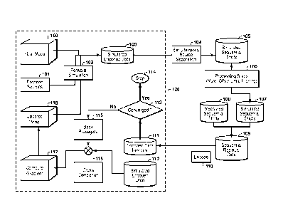
drawings are black and
white reproductions of color originals. Copies of the U.S. counterpart
application or
publication with 20 color drawings may be obtained from the U.S. Patent and
Trademark
Office upon request and payment of the necessary fee.
[0034] The present invention and its advantages will be better understood
by referring to
the following detailed description and the attached drawings in which:
Fig. 1 is a flowchart showing basic steps in the present inventive method for
simultaneous
source inversion for a non-fixed receiver geometry problem in an embodiment in
which the
encoded predicted data are separated using a source separation method;
Fig. 2 is a flowchart showing basic steps in the present inventive method for
simultaneous
source inversion for a non-fixed receiver geometry problem in an embodiment in
which the
encoded predicted data as well as encoded measured data are separated using a
source
separation method to reduce error in the source separation process; and
- 12 -
CA 02807575 2013-02-05
WO 2012/047378 PCT/US2011/047770
Figs. 3 and 4 are flowcharts showing basic steps in the present inventive
method for
simultaneous source inversion for a non-fixed receiver geometry problem in two
embodiments in which the incorrect encoded data residuals are corrected by the
encoded part
of the missing data obtained from a source separation method.
[0035] The invention will be described in connection with example
embodiments.
However, to the extent that the following detailed description is specific to
a particular
embodiment or a particular use of the invention, this is intended to be
illustrative only, and is
not to be construed as limiting the scope of the invention. On the contrary,
it is intended to
cover all alternatives, modifications and equivalents that may be included
within the scope of
the invention, as defined by the appended claims.
DETAILED DESCRIPTION OF EXAMPLE EMBODIMENTS
[0036] The present inventive method uses source encoding and decoding
(i.e. source
separation) to circumvent the fixed receiver assumption and is applicable for
marine streamer
as well as land acquisition geometry. In a typical marine streamer and land
acquisition, the
data coverage is often insufficient to satisfy the fixed receiver geometry
thus limiting the
benefits of simultaneous source full wave inversion ("FWI") proposed by Krebs
at. al [5,18].
In addition to geometry considerations, the field data need to be processed to
conform to the
physics of the forward simulation used in the inversion. For example, to use
acoustic
inversion for inverting elastic data, far offsets are typically muted and the
data are processed
to remove other elastic effects. Other practical aspects such as event
(reflections, refractions,
multiples) based windowing for FWI inversion must assume fixed receiver
geometry, an
assumption often not satisfied in practice.
[0037] Most of the work using encoding and decoding has been focused on
processing
and imaging (migration algorithms) of seismic data (Ikelle [17], Berkhout
[16], Beasley et al.
[26], Stefani et al. [22], Verschuur and Berkhout [23]). Some of the published
work on
inversion is by Krebs et al. [5,18], Hinkley [4], Ben-Hadj-Ali et al. [15] and
Herrmann [24]
for inverting full waveform data. A main idea of the present invention is to
utilize the power
of simultaneous sources (and/or receivers) encoding for the forward modeling,
back
propagation and inversion process but at the same time be able to handle
practical aspects of
data limitation commonly encountered in field surveys (both land and marine).
- 13 -
CA 02807575 2013-02-05
WO 2012/047378 PCT/US2011/047770
[0038] Krebs et al. [5,16] show that the encoded simultaneous source cost
function can be
computed more efficiently than conventional cost functions while still
providing accurate
inversions. The simultaneous source cost function is defined here as (compare
with equation
(2) above):
G
Ssim W (M) = M ,1C
(Eqn. 6)
G=1 geG
where a summation over receivers and time samples is implied as in Eqn. (2),
and:
Ng NG
E= E E defines a sum over gathers by sub groups of gathers,
g=1 G=1 g-GG
Ssun = cost function for simultaneous source data,
= the groups of simultaneous generalized sources, and
NG = the number of groups,
Cg = functions of time that are convolved (CI) with each gather's
source signature to
encode the gathers, these encoding functions may be chosen to be approximately
orthogonal with respect to some appropriate operation depending on the
weighting
function W. When W is the L2-Norm the appropriate operation is cross-
correlation.
[0039] The outer summation in Eqn. (6) is over groups of simultaneous
generalized
sources corresponding to the gather type (e.g. points sources for common shot
gathers). The
inner summation, over g, is over the gathers that are grouped for simultaneous
computation.
For some forward modeling methods, such as finite difference modeling, the
computation of
the forward model for summed generalized sources (the inner sum over g EG) can
be
performed in the same amount of time as the computation for a single source.
Therefore, as
shown in Krebs et. al. [5] cY(M,EciOwg) can be computed very efficiently using
Algorithm 3.
1. Simulate Kaie(M,EciOwg) using a single run of the simulator using EciOwg as
the
source,
2. Convolve each measured data gather with the cg encoding functions, then sum
the
resulting encoded gathers (i.e. E cg vobs(w 0),
- 14 -
CA 02807575 2013-02-05
WO 2012/047378 PCT/US2011/047770
3. Subtract the result of step 2 from the result of step 1.
Algorithm 3 ¨ Algorithm for computing the encoded simultaneous-source data
residual. [NOTE: To compute the cost function, the residual needs to be
evaluated with the function W; for example, least squares.]
[0040] Again as shown in Krebs et al. [5] this algorithm can compute
Ssini(M) a factor of
Ng/Nu times faster than S(M) from Eqn. (2).
[0041] Many types of encoding functions cg can be used in equation (6)
including but not
limited to:
= Linear, random, chirp and modified-chirp frequency-dependent phase
encoding as presented in Romero et al. [13];
= The frequency independent phase encoding as presented in Jing et al.
[14];
= Random time shift encoding;
= Frequency division multiplexing (FDMA), time division multiplexing
(TDMA) and code division multiplexing (CDMA) used in
telecommunications.
[0042] Some of these encoding techniques will work better than others
depending upon
the application, and some can be combined. In particular, good results have
been obtained
using frequency dependent random phase encoding and also by combining
frequency
independent encoding of nearby sources with frequency dependent random phase
encoding
for more widely separated sources. An indication of the relative merits of
different encodings
can be obtained by running test inversions with each set of encoding functions
to determine
which converges faster.
[0043] It should be noted that the simultaneous encoded-source technique
can be used for
many types of inversion cost function. In particular, it could be used for
cost functions based
on other norms than L2 discussed above. It could also be used on more
sophisticated cost
functions than the one presented in Equation 2, including regularized cost
functions. Finally,
the simultaneous encoded-source method could be used with any type of global
or local cost
- 15 -
CA 02807575 2013-02-05
WO 2012/047378 PCT/US2011/047770
function inversion method including Monte Carlo, simulated annealing, genetic
algorithm,
evolution algorithm, gradient line search, conjugate gradients and Newton's
method.
[0044] The
present inventive method can also be used in conjunction with various types
of generalized source techniques, such as those suggested by Berkhout [7]. In
this case,
rather than encoding different point source gather signatures, one would
encode the
signatures for different synthesized plane waves.
[0045] Some variations on the embodiment described above include:
= The cg encoding functions can be changed for each iteration of the
inversion.
In at least some instances this leads to faster convergence of the inversion.
= In some cases
(e.g., when the source sampling is denser than the receiver
sampling) it may be advantageous to use reciprocity to treat the actual
receivers as computational sources, and encode the receivers instead of the
sources.
= This invention is not limited to single-component point receivers. For
example, the receivers could be receiver arrays or they could be multi-
component receivers.
= The method may be improved by optimizing the encoding to yield the
highest
quality inversion. For example the encoding functions could be optimized to
reduce the number of local minima in the cost function. The encoding
functions could be optimized either by manual inspection of tests performed
using different encoding functions or using an automated optimization
procedure.
= Acquisition of simultaneous encoded-source data could result in
significant
geophysical data acquisition cost savings.
= For marine
seismic data surveys, it would be very efficient to acquire encoded
source data from multiple simultaneously operating marine vibrators that
operate continuously while in motion.
- 16 -
CA 02807575 2013-02-05
WO 2012/047378 PCT/US2011/047770
= As indicated above, the encoding process in the present invention may be
performed in the field acquisition of the data, for example where the pilot
signals of multiple simultaneously operating vibrators are encoded with
different encoding functions. In the attached claims, steps referring to
encoding geophysical data, or to geophysical data from encoded sources, or to
obtaining encoded gathers of geophysical data will be understood to include
obtaining data already encoded in the field acquisition process, except where
the context clearly indicates that encoding is occurring in a data processing
step.
= Other
definitions for the cost function may be used, including the use of a
different norm (e.g. Li norm (absolute value) instead of L2 norm), and
additional terms to regularize and stabilize the inversion (e.g. terms that
would
penalize models that aren't smooth or models that are not sparse).
[0046] A
main idea of the present invention is to use simultaneous source encoding and
simultaneous source separation for full waveform inversion in such a way as to
lessen the
impact when the fixed receiver assumption is compromised, and thereby make
simultaneous
source FWI more applicable to general data geometries. Figure 1 shows basic
steps in one
embodiment of the present inventive method. Following the flow chart shown in
Figure 1,
the steps are given next. The discussion that follows will be in terms of
encoded sources;
however, alternatively the receivers may be encoded instead of or in addition
to the sources.
[0047] 1. For
a given physical properties model of the subsurface (100), the
survey sources (i.e., source locations) are encoded to form a simultaneous
encoded source
(101) which is used in the forward modeling, or simulation, (102) to generate
simulated
encoded data (103). The encoded data are generated assuming fixed receiver
geometry with
all receivers being live for the encoded source.
[0048] 2.
Since the field data typically violate fixed receiver geometry to at least
some extent, the encoded data are separated into individual shots using a
source separation
technique (104) such as that described by Neelamani et al. [19,20,21].
Neelamani's source
separation relies on the assumption that the Green's function of the model has
sparse
representation in a transform domain such as a curvelet or wavelet domain.
With the
knowledge of the encoding scheme and assuming sparsity of Green's function,
the shots can
- 17 -
CA 02807575 2013-02-05
WO 2012/047378 PCT/US2011/047770
be separated using for example Li norm inversion in the transformed domain.
This
separation problem can be solved for single encoded shot data for the whole
model domain,
or it can be applied to multiple sets of encoded shot data. Persons who work
in the technical
field will know of a variety of source separation techniques that can be used
as an alternative
to that of Neelamani et al. [19,20,21]. For example, Spitz et al. [28]
proposed a prediction-
subtraction approach which first estimates the primary wavefield of the second
source and
then subtracts it from the total wavefield via a PEF-based adaptive
subtraction. Akerberg et
al. [27] used sparse Radon transforms for the source separation. For all
source separation
algorithms, more than one encoded dataset is preferable.
[0049] 3. The source separation described in the previous step is
crucial to
handle practical data geometries. With the separated shots (105), whatever
processing steps
that may be necessary may be applied (106) so that the simulated data conform
to the field
data. Thus, with the separated shots, the data can be processed to conform to
the field data
acquisition geometry such as offset muting, i.e. removing the near and far-
offsets, muting
based on type of arrivals such as transmission versus reflection component of
data, or
removing the elastic component of the data if the governing forward engine is
based on an
acoustic assumption. Therefore, this general step of data processing with the
separated shots
to make the predicted data (107) similar to the measured data geometry (108)
as well as make
the data conform to the level of the physics allows production of sequential
data residuals
(109), i.e. data residuals for selected shots gathers. A data residual is a
measure of the
difference between a measured data value and a corresponding predicted data
value.
[0050] 4. These data residuals, which are sequential data
residuals (109) by
virtue of the source separation step 104, are encoded (110) using the same or
different
encoding scheme as used in step 101 to produce encoded data residuals (111).
This is a
significant step since the gaps in the data due to acquisition geometry or due
to user choice of
specific events in the data are now in these encoded data residuals (111).
Next, the encoded
data residuals are used to compute the gradient of the objective function
(117). For example,
the residuals may be back-propagated (115) using the adjoint state equation
and cross-
correlated (116) with the forward-propagated data (112) from 103 using the
simultaneous
source to calculate the gradient of the objective function to be minimized as
described in PCT
Patent Application Publication No. WO 2009/117174. Note that the simulated
encoded data
112 may, but do not have to be, the same as the simulated encoded data 103,
because they
- 18 -
CA 02807575 2013-02-05
WO 2012/047378 PCT/US2011/047770
may be encoded with different encoding functions; however the encoding in 112
must match
the encoding in 111.
[0051] 5. In the final step, the model is updated (118) using the
computed
gradient from the previous step. A variety of well known optimization methods,
such as
steepest descent, conjugate gradients, or Newton's method can be used to do
the model
updating to ensure that the value of the objective function decreases. The
simultaneous
source inversion algorithm represented by the steps within dashed line box 120
is based on
WO 2009/117174, but any inversion or forward modeling (manual adjustment)
algorithm
may be used.
[0052] For processing and imaging, the accuracy of the source separation is
important, since any artifact arising due to source separation process
eventually is mapped
into the final image. In previous similar work where source separation is
used, considerable
effort is made to choose the type of encoding to ensure improved accuracy of
separation
(Ikelle [17]). It is believed that the accuracy requirement will be relaxed
for the inversion
application of this invention since the small inaccuracies in the data
residuals due to source
separation can be handled via a line search and model regularization process
during the
inversion step. For inversion applications, a key is to make the predicted
data that are
subtracted from measured data conform to the acquisition geometry and adhere
to the level of
the physics being applied (for example, muting the large offsets when
anisotropic effects are
present in the data and the forward simulation algorithm assumes an isotropic
earth model).
Having achieved that via processing the separated shots removes the large
errors in the data
residuals.
[0053] Although it is believed that the small inaccuracies in source
separation can be
handled in the inversion process, large errors can still be a problem.
Therefore, an alternative
embodiment of the present inventive method is designed to handle the large
errors due to
source separation, and may be used when this is believed to be a problem. An
example of this
alternative embodiment is illustrated by the flowchart of Figure 2. To
replicate the errors due
to separation, the measured data are encoded (108b) using the same encoding
scheme and
using source separation (108c) to obtain measured separated shot gathers.
These measured
separated shot gathers can be used to compute the data residuals instead of
the original
measured shots.
- 19 -
CA 02807575 2013-02-05
WO 2012/047378 PCT/US2011/047770
[0054] Another way to view this problem is to determine encoded data
residuals that
are corrected for the missing far and near offsets traces. So, another
alternative can be
described as follows, shown in Figure 3. First, the data residual (309) that
is a difference
between simulated encoded data (103) and the encoded measured data (308) with
missing far
and near offsets is formed (i.e., simulated encoded minus encoded measured).
This data
residual (309) is unsuitable for computing the gradient since the simulated
encoded data
(103) has contribution from the missing part of the data (e.g., near and far
offset traces)
whereas the measured encoded data (308) do not have a contribution from
missing data. In
the next step (304), source separation of the simulated encoded data is
performed, and the
resulting estimate of simulated sequential shots (305) are processed, but
instead of removing
the missing data part (such as muting out the near and far offsets from the
separated shot
gathers (306)), the missing part (such as near and far offsets) of the shot
gathers (307) is
encoded. This encoded missing part of the data (307) can be subtracted (310)
from the
incorrect data residual (309) to compensate for the missing data information
and obtain a
corrected data residual (311). (It is subtracted, rather than added, because
it needs to offset
simulated encoded data which are present in the incorrect data residual with a
positive sign,
since the residual is defined ¨ see above ¨ as simulated encoded data minus
encoded
measured data. If that definition, which is arbitrary, were reversed, then the
missing data
would be added to the residual. Moreover, instead of treating the missing-data
correction as
a subtraction from the simulated data contribution to the data residual, it
could be regarded as
an addition to the measured data contribution to the data residual. It will be
understood that
the present invention, including be appended claims, includes all such
equivalent
approaches.) The key difference of this embodiment compared to that described
in Fig. 1 is
encoded data residuals are corrected in this embodiment rather than being
generated after
processing as shown in Fig. 1. If the source separation is perfect, then the
two approaches
(Fig. 1 and Fig. 3) are mathematically equivalent; however, in the presence of
source
separation errors, it is possible that the correction approach shown in Fig. 3
may provide a
better result.
[0055] Figure 4 describes an alternative to the data residual
correction method
described Fig. 3. Similar to the method in Fig. 3, first, the encoded data
residual (409) that is
a difference between simulated encoded data (103) and the encoded measured
data (408) with
missing far and near offsets is formed. In the next step, source separation
(404) is performed
- 20 -
CA 02807575 2013-02-05
WO 2012/047378 PCT/US2011/047770
using the encoded data residual, resulting in sequential residual data (405).
The source
separation estimates the residual between the sequential source simulated data
and sequential
source measured data. At source and receiver combinations that are not present
in the
measured data (not acquired), the estimated residual consists of only the
simulated data. This
missing part (such as near and far offsets) of the shot gathers, determined by
processing steps
(406), is encoded (407) and then subtracted (410) from the incorrect data
residual (409) to
obtain a corrected data residual (311). The source separation result can be
improved by using
multiple encoded data residuals, each computed using a different encoding. In
such a case,
many of the encoded data residuals can be corrected and then used to update
the initial
model.
[0056] Other variations to the embodiments of Figs. 1- 4 are possible.
An advantage
of all embodiments of the present inventive method is that they can handle a
variety of field
geometries to invert real data and realize speed-up due to the simultaneous
encoding. The key
step of simultaneous source separation followed by processing steps makes the
algorithm
practical for field data sets. Neelamani et al. [20,21] show that the compute
time for
simultaneous source separation is significantly less compared to one forward
simulation run,
which is one of the primary advantages to this approach. Another embodiment of
this
invention determines the optimal number of sources so that the separation
problem is well-
posed. Using fewer, farther spaced sources for encoding helps the source
separation
problem; however, too much separation may cause spatial aliasing in the model
update and
eventually degrade the subsurface model. On the other hand, encoding too many
closely
spaced sources makes the separation problem difficult. Thus, depending on the
scale length
of the subsurface model to be updated and available sources in a survey, an
optimal source
spacing (i.e. optimal number of sources) can be chosen to balance the two
competing
considerations. Thus, to make the source separation problem well-posed may
require not
using all the sources recorded in a survey. In another embodiment, the
encoding is changed
every iteration of the inversion, or at least in some iterations, as taught by
WO 2008/042081.
[0057] The foregoing application is directed to particular embodiments
of the present
invention for the purpose of illustrating it. It will be apparent, however, to
one skilled in the
art, that many modifications and variations to the embodiments described
herein are possible.
All such modifications and variations are intended to be within the scope of
the present
invention, as defined in the appended claims. Persons skilled in the art will
readily recognize
- 21 -
CA 02807575 2013-02-05
WO 2012/047378 PCT/US2011/047770
that in preferred embodiments of the invention, at least some of the steps in
the present
inventive method are performed on a computer, i.e. the invention is computer
implemented.
In such cases, the resulting updated physical properties model may be
downloaded,
displayed, or saved to computer storage.
References
1. Tarantola, A., "Inversion of seismic reflection data in the acoustic
approximation,"
Geophysics 49, 1259-1266 (1984).
2. Sirgue, L., and Pratt G. "Efficient waveform inversion and imaging: A
strategy for
selecting temporal frequencies," Geophysics 69, 231-248 (2004).
3. Fallat, M. R., Dosso, S. E., "Geoacoustic inversion via local, global,
and hybrid
algorithms," Journal of the Acoustical Society of America 105, 3219-3230
(1999).
4. Hinkley, D. and Krebs, J., "Gradient computation for simultaneous source
inversion,"
PCT Patent Application Publication No. WO 2009/117174.
5. Krebs, J. R., Anderson, J. A., Neelamani, R., Hinkley, D., Jing, C.,
Dickens, T.,
Krohn, C., Traynin, P., "Iterative inversion of data from simultaneous
geophysical sources,"
PCT Patent Application Publication No. WO 2008/042081.
6. Van Manen, D. J., Robertsson, J.O.A., Curtis, A., "Making wave by time
reversal,"
SEG International Exposition and 7 5th Annual Meeting Expanded Abstracts, 1763-
1766
(2005).
7. Berkhout, A. J., "Areal shot record technology," Journal of Seismic
Exploration 1,
251-264 (1992).
8. Zhang, Y., Sun, J., Notfors, C., Gray, S. H., Cherris, L., Young, J.,
"Delayed-shot 3D
depth migration," Geophysics 70, E21-E28 (2005).
9. Van Riel, P., and Hendrik, W. J. D., "Method of estimating elastic and
compositional
parameters from seismic and echo-acoustic data," U.S. Patent No. 6,876,928
(2005).
- 22 -
CA 02807575 2013-02-05
WO 2012/047378 PCT/US2011/047770
10. Mora, P., "Nonlinear two-dimensional elastic inversion of multi-offset
seismic data,"
Geophysics 52, 1211-1228 (1987).
11. Ober, C. C., Romero, L. A., Ghiglia, D. C., "Method of Migrating
Seismic Records,"
U.S. Patent No. 6,021,094 (2000).
12. &elle, L. T., "Multi-shooting approach to seismic modeling and
acquisition," U.S.
Patent No. 6,327,537 (2001).
13. Romero, L. A., Ghiglia, D. C., Ober, C. C., Morton, S. A., "Phase
encoding of shot
records in prestack migration," Geophysics 65, 426-436 (2000).
14. Jing X., Finn, C. J., Dickens, T. A., Willen, D. E., "Encoding multiple
shot gathers in
prestack migration," SEG International Exposition and 70th Annual Meeting
Expanded
Abstracts, 786-789 (2000).
15. Ben-Hadj-Ali, H., Opertor, S., and Vireus, J., "Three-dimensional
frequency-domain
full waveform inversion with phase encoding," SEG Expanded Abstracts, 2288-
2292 (2009).
16. Berkhout, A. J., "Changing the mindset in seismic data acquisition,"
The Leading
Edge 27-7, 924-938 (2008).
17. &elle, L. T., "Coding and decoding: Seismic data modeling, acquisition,
and
processing," 77th Annual International Meeting, SEG, Expanded Abstracts, 66-70
(2007).
18. Jerome R. Krebs, John E. Anderson, David Hinkley, Ramesh Neelamani,
Sunwoong
Lee, Anatoly Baumstein, and Martin-Daniel Lacasse, "Full-wavefield seismic
inversion using
encoded sources," Geophysics 74-6, WCC177-WCC188 (2009).
19. Neelamani, R., and C. E. Krohn, "Simultaneous sourcing without
compromise,"
presented at the 70th Annual International Conference and Exhibition, EAGE
(2008).
20. Neelamani, R., and C. E. Krohn, "Separation and noise removal for
multiple vibratory
source seismic data," PCT international patent application publication No. WO
2008/123920.
21. Neelamani, R., C. E. Krohn, Krebs, J. R., Deffenbaugh, M., Anderson, J.
E., and
Romberg, J. K., "Efficient seismic forward modeling using simultaneous sources
and
sparsity," SEG Expanded Abstracts, 2107-2111(2009).
-23 -
CA 02807575 2013-02-05
WO 2012/047378 PCT/US2011/047770
22. Stefani, J., G. Hampson, and E. F. Herkenhoff, "Acquisition using
simultaneous
sources," 69th Annual Conference and Exhibition, EAGE, Extended Abstracts,
B006 (2007).
23. Verschuur, D. J., and A. J. Berkhout, "Target-oriented, least-squares
imaging of
blended data," 79th Annual International Meeting, SEG, Expanded Abstracts
(2009).
24. Herrmann, F. J., "Randomized dimensionality reduction for full-waveform
inversion,"
EAGE abstract G001, EAGE Barcelona meeting (2010).
25. Haber, E., Chung M. and Herrmann, "An effective method for parameter
estimation
with PDE constraints with multiple right hand sides," Preprint - UBC
http ://www.math.ubc.ca/¨haber/pubs/PdeOptStochV5.pdf (2010).
26. Beasley, C., "A new look at marine simultaneous sources," The Leading
Edge 27(7),
914-917 (2008).
27. Akerberg, P., G. Hampson, J. Rickett, H. Martin, and J. Cole,
"Simultaneous source
separation by sparse radon transform," 78th Annual International Meeting, SEG,
Expanded
Abstracts, 2801-2805 (2008).
28. Spitz, S., G. Hampson, and A. Pica, "Simultaneous source separation: a
prediction-
subtraction approach," 78th Annual International Meeting, SEG, Expanded
Abstracts, 2811-
2815 (2008).
- 24 -