Note: Descriptions are shown in the official language in which they were submitted.
81771967
SEISMIC TRACE ATTRIBUTE
RELATED APPLICATIONS
[0001] This application claims the benefit of U.S. Provisional Patent
Application having Serial No. 61/659,036, flied 13 June 2012.
= BACKGROUND
[0002] Reflection seismology finds use in geophysics, for example, to
estimate
properties of subsurface formations. As an example, reflection seismology may
provide seismic data representing waves of elattic energy (e.g., as
transmitted by P-
waves and S-waves, in a frequency range of approximately 1 Hz to approximately
100 HZ). Seismic data may be processed and interpreted, for example, to
understand better composition, fluid content, extent and geometry of
subsurface
rocks. Various techniques described herein pertain to processing of data such
as,
for example, seismic data.
SUMMARY
[0003] A method can include providing seismic data for a subsurface
region
that includes a reflector, processing at least a portion of the seismic data
to generate
at least one path that extends orthogonally to the reflector and outputting
output data
representing the at least one path. A system can include one or more
processors for
processing information, memory operatively coupled to the one or more
processors,
and modules that include instructions stored in the memory arid executable by
at
least one of the one or more processors, where the modules include a provision
module to provide seismic data for a subsurface region that includes a
reflector, a
process module to process at least a portion of the seismic data to generate
at least
one path that extends orthogonally to the reflector, and an output module to
output
data representing the at least one path. One or more computer-readable storage
media can include computer-executable instructions to instruct a computing
system
to access seismic data for a subsurface region that includes a reflector,
process at
least a portion of the seismic data to generate at least one path that extends
1
CA 2818790 2019-11-04
81771967
orthogonally to the reflector, and output data representing the at least one
path.
Various other apparatuses, systems, methods, etc., are also disclosed.
[0003a] According to one aspect of the present invention, there is
provided a
method comprising: receiving seismic data corresponding to a subsurface region
that
comprises a reflector, wherein the seismic data is generated based on seismic
waves
detected using a seismic receiver, wherein the seismic waves propagate through
at
least a portion of the subsurface region and are reflected by the reflector;
processing
at least a portion of the seismic data to generate at least one path that
extends
orthogonally to an inline dip and a crossline dip of the reflector; and
outputting output
data representing the at least one path.
[0003b] According to another aspect of the present invention, there is
provided
a system comprising: one or more processors for processing information; memory
storing instructions that, when executed by at least one of the one or more
processors, cause the system to perform operations, the operations comprising:
receiving seismic data corresponding to a subsurface region that comprises a
reflector, wherein the seismic data is generated based on seismic waves
detected
using a seismic receiver, wherein the seismic waves propagate through at least
a
portion of the subsurface region and are reflected by the reflector;
processing at least
a portion of the seismic data to generate at least one path that extends
orthogonally
to an inline dip and a crossline dip of the reflector; and outputting output
data
representing the at least one path.
[0003c] According to still another aspect of the present invention, there
is
provided one or more non-transitory computer-readable storage media comprising
computer-executable instructions to instruct a computing system to: receive
seismic
data corresponding to a subsurface region that comprises a reflector, wherein
the
seismic data is generated based on seismic waves detected using a seismic
receiver,
wherein the seismic waves propagate through at least a portion of the
subsurface
region and are reflected by the reflector; process at least a portion of the
seismic data
2
Date Recue/Date Received 2020-09-23
81771967
to generate at least one path that extends orthogonally to an inline dip and a
crossline dip of the reflector; and output data representing the at least one
path.
[0004] This summary is provided to introduce a selection of concepts that
are
further described below in the detailed description. This summary is not
intended to
identify key or essential features of the claimed subject matter, nor is it
intended to be
used as an aid in limiting the scope of the claimed subject matter.
BRIEF DESCRIPTION OF THE DRAWINGS
[0005] Features and advantages of the described implementations can be
more readily understood by reference to the following description taken in
conjunction
with the accompanying drawings.
[0006] Fig. 1 illustrates an example system that includes various
components
for modeling a geologic environment;
[0007] Fig. 2 illustrates examples of formations, an example of a
convention for
dip, an example of data acquisition, and an example of a system;
[0008] Fig. 3 illustrates an example of a method for acquiring and
processing
data;
[0009] Fig. 4 illustrates an example of a method for processing data;
[0010] Fig. 5 illustrates an example of output data;
[0011] Fig. 6 illustrates examples of images of data;
[0012] Fig. 7 illustrates examples of images of data;
[0013] Fig. 8 illustrates examples of images of data;
[0014] Fig. 9 illustrates examples of methods; and
2a
CA 2818790 2019-11-04
81771967
[0015] Fig. 10 illustrates example components of a system and a networked
system.
DETAILED DESCRIPTION
[0016] The following description includes the best mode presently
contemplated for practicing the described implementations. This description is
not to
be taken in a limiting sense, but rather is made merely for the purpose of
describing
the general principles of the implementations. The scope of the described
implementations should be ascertained with reference to the issued claims.
2b
CA 2818790 2019-11-04
CA 02818790 2013-06-12
IS12.2368-CA-NP
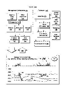
[0017] Fig. 1 shows an example of a system 100 that includes various
management components 110 to manage various aspects of a geologic environment
150 (e.g., an environment that includes a sedimentary basin, a reservoir 151,
one or
more fractures 153, etc.). For example, the management components 110 may
allow for direct or indirect management of sensing, drilling, injecting,
extracting, etc.,
with respect to the geologic environment 150. In turn, further information
about the
geologic environment 150 may become available as feedback 160 (e.g.,
optionally
as input to one or more of the management components 110).
[0018] In the example of Fig. 1, the management components 110 include a
seismic data component 112, an additional information component 114 (e.g.,
well/logging data), a processing component 116, a simulation component 120, an
attribute component 130, an analysis/visualization component 142 and a
workflow
component 144. In operation, seismic data and other information provided per
the
components 112 and 114 may be input to the simulation component 120.
[0019] In an example embodiment, the simulation component 120 may rely on
entities 122. Entities 122 may include earth entities or geological objects
such as
wells, surfaces, reservoirs, etc. In the system 100, the entities 122 can
include
virtual representations of actual physical entities that are reconstructed for
purposes
of simulation. The entities 122 may include entities based on data acquired
via
sensing, observation, etc. (e.g., the seismic data 112 and other information
114). An
entity may be characterized by one or more properties (e.g., a geometrical
pillar grid
entity of an earth model may be characterized by a porosity property). Such
properties may represent one or more measurements (e.g., acquired data),
calculations, etc.
[0020] In an example embodiment, the simulation component 120 may rely on
a software framework such as an object-based framework. In such a framework,
entities may include entities based on pre-defined classes to facilitate
modeling and
simulation. A commercially available example of an object-based framework is
the
MICROSOFT @ .NETTm framework (Redmond, Washington), which provides a set of
extensible object classes. In the .NETTm framework, an object class
encapsulates a
module of reusable code and associated data structures. Object classes can be
used to instantiate object instances for use in by a program, script, etc. For
3
CA 02818790 2013-06-12
IS12.2368-CA-NP
example, borehole classes may define objects for representing boreholes based
on
well data.
[0021] In the example of Fig. 1, the simulation component 120 may process
information to conform to one or more attributes specified by the attribute
component
130, which may include a library of attributes. Such processing may occur
prior to
input to the simulation component 120 (e.g., consider the processing component
116). As an example, the simulation component 120 may perform operations on
input information based on one or more attributes specified by the attribute
component 130. In an example embodiment, the simulation component 120 may
construct one or more models of the geologic environment 150, which may be
relied
on to simulate behavior of the geologic environment 150 (e.g., responsive to
one or
more acts, whether natural or artificial). In the example of Fig. 1, the
analysis/visualization component 142 may allow for interaction with a model or
model-based results. As an example, output from the simulation component 120
may be input to one or more other workflows, as indicated by a workflow
component
144.
[0022] As an example, the simulation component 120 may include one or
more features of a simulator such as the ECLIPSETM reservoir simulator
(Schlumberger Limited, Houston Texas), the INTERSECT?'" reservoir simulator
(Schlumberger Limited, Houston Texas), etc. As an example, a reservoir or
reservoirs may be simulated with respect to one or more enhanced recovery
techniques (e.g., consider a thermal process such as SAGD, etc.).
[0023] In an example embodiment, the management components 110 may
include features of a commercially available simulation framework such as the
PETREL seismic to simulation software framework (Schlumberger Limited,
Houston, Texas). The PETREL framework provides components that allow for
optimization of exploration and development operations. The PETREL framework
includes seismic to simulation software components that can output information
for
use in increasing reservoir performance, for example, by improving asset team
productivity. Through use of such a framework, various professionals (e.g.,
geophysicists, geologists, and reservoir engineers) can develop collaborative
workflows and integrate operations to streamline processes. Such a framework
may
4
CA 02818790 2013-06-12
4
IS12.2368-CA-NP
be considered an application and may be considered a data-driven application
(e.g.,
where data is input for purposes of simulating a geologic environment).
[0024] In an example embodiment, various aspects of the management
components 110 may include add-ens or plug-ins that operate according to
specifications of a framework environment. For example, a commercially
available
framework environment marketed as the OCEAN framework environment
(Schlumberger Limited, Houston, Texas) allows for integration of add-ons (or
plug-
ins) into a PETREL framework workflow. The OCEAN framework environment
leverages .NET tools (Microsoft Corporation, Redmond, Washington) and offers
stable, user-friendly interfaces for efficient development. In an example
embodiment, various components may be implemented as add-ons (or plug-ins)
that
conform to and operate according to specifications of a framework environment
(e.g.,
according to application programming interface (API) specifications, etc.).
[0025] Fig. 1 also shows an example of a framework 170 that
includes a
model simulation layer 180 along with a framework services layer 190, a
framework
core layer 195 and a modules layer 175. The framework 170 may include the
commercially available OCEAN framework where the model simulation layer 180
is
the commercially available PETREL model-centric software package that hosts
OCEAN framework applications. In an example embodiment, the PETREL
software may be considered a data-driven application. The PETREL software can
include a framework for model building and visualization. Such a model may
include
one or more grids.
[0026] The model simulation layer 180 may provide domain objects
182, act
as a data source 184, provide for rendering 186 and provide for various user
interfaces 188. Rendering 186 may provide a graphical environment in which
applications can display their data while the user interfaces 188 may provide
a
common look and feel for application user interface components.
[0027] In the example of Fig. 1, the domain objects 182 can include
entity
objects, property objects and optionally other objects. Entity objects may be
used to
geometrically represent wells, surfaces, reservoirs, etc., while property
objects may
be used to provide property values as well as data versions and display
parameters.
For example, an entity object may represent a well where a property object
provides
CA 02818790 2013-06-12
IS12.2368-CA-NP
log information as well as version information and display information (e.g.,
to display
the well as part of a model). =
[0028] In the example of Fig. 1, data may be stored in one or more data
sources (or data stores, generally physical data storage devices), which may
be at
the same or different physical sites and accessible via one or more networks.
The
model simulation layer 180 may be configured to model projects. As such, a
particular project may be stored where stored project information may include
inputs,
models, results and cases. Thus, upon completion of a modeling session, a user
may store a project. At a later time, the project can be accessed and restored
using
the model simulation layer 180, which can recreate instances of the relevant
domain
objects.
[0029] In the example of Fig. 1, the geologic environment 150 may be
outfitted
with any of a variety of sensors, detectors, actuators, etc. For example,
equipment
152 may include communication circuitry to receive and to transmit information
with
respect to one or more networks 157. Such information may include information
associated with downhole equipment 154, which may be equipment to acquire
information, to assist with resource recovery, etc. Other equipment 156 may be
located remote from a well site and include sensing, detecting, emitting or
other
circuitry. Such equipment may include storage and communication circuitry to
store
and to communicate data, instructions, etc. As an example, one or more
satellites
may be provided for purposes of communications, data acquisition, etc. For
example, Fig. 1 shows a satellite 155 that may be configured for
communications,
noting that the satellite 155 may additionally or alternatively include
circuitry for
imagery (e.g., spatial, spectral, temporal, radiometric, etc.).
[0030] As mentioned, the system 100 may be used to perform one or more
workflows. A workflow may be a process that includes a number of worksteps. A
workstep may operate on data, for example, to create new data, to update
existing
data, etc. As an example, a may operate on one or more inputs and create one
or
more results, for example, based on one or more algorithms. As an example, a
system may include a workflow editor for creation, editing, executing, etc. of
a
workflow. In such an example, the workflow editor may provide for selection of
one
or more pre-defined worksteps, one or more customized worksteps, etc. As an
example, a workflow may be a workflow implementable in the PETREL software,
6
i
CA 02818790 2013-06-12
1S12.2368-CA-NP
for example, that operates on seismic data, seismic attribute(s), etc. As an
example,
a workflow may be a process implementable in the OCEAN D framework. As an
example, a workflow may include one or more worksteps that access a module
such
as a plug-in (e.g., external executable code, etc.).
[0031] Fig. 2 shows an example of a formation 201, an example of a borehole
210, an example of a convention 215 for dip, an example of a data acquisition
process 220, and an example of a System 250.
[0032] As shown, the formation 201 includes a horizontal surface and
various
subsurface layers. As an example, a borehole may be vertical. As another
example,
a borehole may be deviated. In the example of Fig. 2, the borehole 210 may be
considered a vertical borehole, for example, where the z-axis extends
downwardly
normal to the horizontal surface of the formation 201.
[0033] As to the convention 215 for dip, as shown, the three dimensional
orientation of a plane can be defined by its dip and strike. Dip is the angle
of slope
of a plane from a horizontal plane (e.g., an imaginary plane) measured in a
vertical
plane in a specific direction. Dip may be defined by magnitude (e.g., also
known as
angle or amount) and azimuth (e.g., also known as direction). As shown in the
convention 215 of Fig. 2, various angles 0 indicate angle of slope downwards,
for
example, from an imaginary horizontal plane (e.g., flat upper surface);
whereas,
azimuth refers to the direction towards which a dipping plane slopes (e.g.,
which may
be given with respect to degrees, compass directions, etc.). Another feature
shown
in the convention of Fig. 2 is strike, which is the orientation of the line
created by the
intersection of a dipping plane and a horizontal plane (e.g., consider the
flat upper
surface as being an imaginary horizontal plane).
[0034] Some additional terms related to dip and strike may apply to an
analysis, for example, depending on circumstances, orientation of collected
data,
etc. One term is "true dip" (see, e.g., DipT in the convention 215 of Fig. 2).
True dip
is the dip of a plane measured directly perpendicular to strike (see, e.g.,
line directed
northwardly and labeled "strike" and angle a90) and also the maximum possible
value
of dip magnitude. Another term is "apparent dip" (see, e.g., DipA in the
convention
215 of Fig. 2). Apparent dip may be the dip of a plane as measured in any
other
direction except in the direction of true dip (see, e.g., OA as DipA for angle
a);
however, it is possible that the apparent dip is equal to the true dip (see,
e.g., 0 as
7
CA 02818790 2013-06-12
IS12.2368-CA-NP
DipA = Dip-r for angle asio with respect to the strike). In other words, where
the term
apparent dip is used (e.g., in a method, analysis, algorithm, etc.), for a
particular
dipping plane, a value for "apparent dip" may be equivalent to the true dip of
that
particular dipping plane.
[0035] As shown in the convention 215 of Fig. 2, the dip of a plane as seen
in
a cross-section exactly perpendicular to the strike is true dip (see, e.g.,
the surface
with 0 as DipA = DipT for angle a90 with respect to the strike). As indicated,
dip
observed in a cross-section in any other direction is apparent dip (see, e.g.,
surfaces
labeled DipA). Further, as shown in the convention 215 of Fig. 2, apparent dip
may
be approximately 0 degrees (e.g., parallel to a horizontal surface where an
edge of a
cutting plane runs along a strike direction).
[0036] In terms of observing dip in wellbores, true dip is observed in
wells
drilled vertically. In wells drilled in any other orientation (or deviation),
the dips
observed are apparent dips (e.g., which are referred to by some as relative
dips). In
order to determine true dip values for planes observed in such boreholes, as
an
example, a vector computation (e.g., based on the borehole deviation) may be
applied to one or more apparent dip values.
[0037] As mentioned, another term that finds use in sedimentological
interpretations from borehole images is "relative dip" (e.g., DipR). A value
of true dip
measured from borehole images in rocks deposited in very calm environments may
be subtracted (e.g., using vector-subtraction) from dips in a sand body. The
resulting dips from such a process are called relative dips and find use in
interpreting
sand body orientation.
[0038] A convention such as the convention 215 may be used with respect to
an analysis, an interpretation, an attribute, etc. (see, e.g., various blocks
of the
system 100 of Fig. 1). As an example, various types of features may be
described,
in part, by dip (e.g., sedimentary bedding, faults and fractures, cuestas,
igneous
dikes and sills, metamorphic foliation, etc.).
[0039] Seismic interpretation may aim to identify and classify one or more
subsurface boundaries based at least in part on one or more dip parameters
(e.g.,
angle or magnitude, azimuth, etc.). As an example, various types of features
(e.g.,
sedimentary bedding, faults and fractures, cuestas, igneous dikes and sills,
8
CA 02818790 2013-06-12
=
IS12.2368-CA-NP
metamorphic foliation, etc.) may be described at least in part by angle, at
least in
part by azimuth, etc.
[0040] As shown in the diagram 220 of Fig. 2, a geobody 225 may be present
in a geologic environment. For example, the geobody 225 may be a salt dome. A
salt dome may be a mushroom-shaped or plug-shaped diapir made of salt and may
have an overlying cap rock. Salt domes can form as a consequence of the
relative
buoyancy of salt when buried beneath other types of sediment. Hydrocarbons may
be found at or near a salt dome due to formation of traps due to salt movement
in
association with evaporite mineral sealing. Buoyancy differentials can cause
salt to
begin to flow vertically (e.g., as a salt pillow), which may cause faulting.
In the
diagram 220, the geobody 225 is met by layers which may each be defined by a
dip
angle
[0041] As an example, seismic data may be acquired for a region in the form
of traces. In the example of Fig. 2, the diagram 220 shows acquisition
equipment
222 emitting energy from a source (e.g., a transmitter) and receiving
reflected energy
via one or more sensors (e.g., receivers) strung along an inline direction. As
the
region includes layers 223 and the geobody 225, energy emitted by a
transmitter of
the acquisition equipment 222 can reflect off the layers 223 and the geobody
225.
Evidence of such reflections may be found in the acquired traces. As to the
portion
of a trace 226, energy received may be discretized by an analog-to-digital
converter
that operates at a sampling rate. For example, the acquisition equipment 222
may
convert energy signals sensed by sensor Q to digital samples at a rate of one
sample per approximately 4 ms. Given a speed of sound in a medium or media, a
sample rate may be converted to an approximate distance. For example, the
speed
of sound in rock may be on the order of around 5 km per second. Thus, a sample
time spacing of approximately 4 ms would correspond to a sample "depth"
spacing of
about 10 meters (e.g., assuming a path length from source to boundary and
boundary to sensor). As an example, a trace may be about 4 seconds in
duration;
thus, for a sampling rate of one sample at about 4 ms intervals, such a trace
would
include about 1000 samples where latter-acquired samples correspond to deeper
reflection boundaries. If the 4 second trace duration of the foregoing example
is
divided by two (e.g., to account for reflection), for a vertically aligned
source and
9
CA 02818790 2013-06-12
=
1S12.2368-CA-NP
sensor, the deepest boundary depth may be estimated to be about 10 km (e.g.,
assuming a speed of sound of about 5 km per second).
[0042] In the example of Fig. 2, the system 250 includes one or more
information storage devices 252, one or more computers 254, one or more
networks
260 and one or more modules 270. As to the one or more computers 254, each
computer may include one or more processors (e.g., or processing cores) 256
and
memory 258 for storing instructions (e.g., modules), for example, executable
by at
least one of the one or more processors. As an example, a computer may include
one or more network interfaces (e.g., wired or wireless), one or more graphics
cards,
a display interface (e.g., wired or wireless), etc.
[0043] In the example of Fig. 2, the one or more memory storage devices
252
may store seismic data for a geologic environment that spans kilometers in
length
and width and, for example, around 10 km in depth. Seismic data may be
acquired
with reference to a surface grid (e.g., defined with respect to inline and
crossline
directions). For example, given grid blocks of about 40 meters by about 40
meters, a
40 km by 40 km field may include about one million traces. Such traces may be
considered 3D seismic data where time approximates depth. As an example, a
computer may include a network interface for accessing seismic data stored in
one
or more of the storage devices 252 via a network. In turn, the computer may
process the accessed seismic data via instructions, which may be in the form
of one
or more modules.
[0044] As an example, one or more attribute modules may be provided for
processing seismic data. As an example, attributes may include geometrical
attributes (e.g., dip angle, azimuth, continuity, seismic trace, etc.). Such
attributes
may be part of a structural attributes library (see, e.g., the attribute
component 130 of
Fig. 1). Structural attributes may assist with edge detection, local
orientation and dip
of seismic reflectors, continuity of seismic events (e.g., parallel to
estimated bedding
orientation), etc. As an example, an edge may be defined as a discontinuity in
horizontal amplitude continuity within seismic data and correspond to a fault,
a
fracture, etc. Geometrical attributes may be spatial attributes and rely on
multiple
traces.
[0045] As mentioned, as an example, seismic data for a region may include
= one million traces where each trace includes one thousand samples for a
total of one
CA 02818790 2013-06-12
1S12 2368-CA-NP
billion samples. Resources involved in processing such seismic data in a
timely
manner may be relatively considerable by today's standards. As an example, a
dip
scan approach may be applied to seismic data, which involves processing
seismic
data with respect to discrete planes (e.g., a volume bounded by discrete
planes).
Depending on the size of the seismic data, such an approach may involve
considerable resources for timely processing. Such an approach may look at
local
coherence between traces and their amplitudes, and therefore may be classified
in
the category of "apparent dip."
[0046] As an example, a 2D search-based estimate of coherence may be
performed for a range of discrete dip angles. Such an approach may estimate
coherence using semblance, variance, principle component analysis (PCA), or
another statistical measure along a discrete number of candidate dips and
arrive at
an instantaneous dip based on a coherence peak. As an example, a 3D search-
based estimate of coherence, which may be analogous to a 2D approach, may use
an inline vector and a crossline vector for time dip (e.g., along coherent
peaks in
inline and crossline directions). As an example, dip with maximum coherence
may
be stored as a dip angle/magnitude and dip direction/azimuth. As an example,
an
approach may involve human interaction in a semi-automated manner that
includes
interpretation of horizons in a subterranean formation via user identification
and
selection of horizon features.
(0047] As an example, an attribute may be a trace attribute. For example, a
trace attribute process that generates an iso-frequency attribute may include
performing spectral decomposition on seismic data to generate an
autocorrelation
function followed by cross-correlation using a cosine wave (e.g., cosine
correlation
transform) and the autocorrelation function. Such a process can output an iso-
frequency attribute as a correlation coefficient that measures the correlation
between
a known cosine wave signature of a. particular frequency and the
autocorrelation of
the seismic data. Such a trace attribute process may be applied to a seismic
volume
and, for example, output an iso-frequency attribute cube (e.g., with values
scaled
between -1 and +1, representing correlation). An iso-frequency attribute may
help
reveal variations in lithology that may, for example, indicate stratigraphic
traps for
hydrocarbons.
11
CA 02818790 2013-06-12
=
1S12.2368-CA-NP
[0048] As an example, a trace attribute may be a one-dimensional attribute,
referred to as a 1D trace attribute, where calculations may benefit from input
of
values that are properly spaced along a trace (e.g., or traces). Improper
spacing of
values along a trace may arise under various circumstances, for example,
related to
orientation of seismic data acquisition equipment with respect to one or more
reflectors (e.g., dipping planes, geobodies, etc.), processing of seismic
data, etc. As
an example, properly spaced values for a trace may be defined by their
distances,
times, etc. For example, properly spaced values may be amplitude values for
samples where individual amplitude values have corresponding times or
distances
that may help to preserve one or more characteristics of a wavelet or
wavelets. As
an example, consider amplitude values having corresponding times that help to
preserve frequency of a wavelet.
[0049] Fig. 3 shows an example of a method 300 that demonstrates how
improper spacing, etc., may occur for seismic data (e.g., trace data). In the
method
300, for a data acquisition process 310, various source and receiver pairs are
positioned on a surface 312, below which exists a flat reflector 314 and a
dipping
reflector 316. For each source and receiver pair, a two-way-travel-time (-
15/VT) is
represented as a double headed arrow (e.g., energy wave travel time from the
source to the respective reflector and from the respective reflector to the
receiver).
[0050] In the method 300, for a data process 330, each of the traces for
the
flat reflector 314 and each of the traces for the dipping reflector 316 are
shown as
including a wavelet having an associated time (e.g., At for the flat reflector
314 and
At2 and At3 for the dipping reflector 316). As an example, a wavelet may be
defined as a one-dimensional pulse (e.g., a response from a single reflector).
As an
example, a wavelet may be characterized by amplitude, frequency and phase, for
example, where energy that returns cannot exceed what was input, so that the
energy in any received wavelet decays with time as more partitioning takes
place at
interfaces. As an example, a wavelet may also decay due to loss of energy as
heat
during propagation, for example, higher frequency may result in more heat
losses.
As a consequence, a wavelet may tend to include less high-frequency energy
relative to low frequencies at longer travel-times. As an example, a wavelet
may be
defined, for example, by shape, spectral content (e.g., Ricker wavelet), etc.
12
CA 02818790 2013-06-12
IS12.2368-CA-NP
[0051] Referring to the trace 226 of Fig. 2, a wavelet may have positive
and
negative amplitudes with respect to time (e.g., or depth). As an example,
seismic
data may be organized with respect to inline, crossline and time or depth
dimensions. As an example, seismic data may be organized as voxels where each
sample (e.g., amplitude) is deemed representative of a volume of a subsurface
environment, for example, which may be defined by inline, crossline and time
or
depth indexes or dimensions. In the example trace 226 of Fig. 2, the amplitude
of
each sample may optionally be stored with respect to a common inline index, a
common crossline index and a series of time or depth indexes. In such an
example,
amplitude and time (or depth) may be preserved (e.g., proper where meaningful
acquisition times are provided for amplitude values).
[0052] In the method 300, a wavelet migration process 350 may be applied to
migrate the wavelets of the traces associated with the dipping reflector 316.
As
shown in the example of Fig. 3, each of the wavelets is migrated along a curve
(e.g.,
radius of a circle) to align each of the wavelets with the dipping reflector
316. In
such an example, the migration process 350 may result in wavelets being
oriented
normal to a plane defined by the dipping reflector 316. However, application
of a
discretization process 370 (e.g., pixilation, voxelation, etc.) or flattening
process 390
can result in a migrated wavelet being "smeared" across a dimension or
dimensions.
For example, as shown, the process 370 may produce a migrated wavelet that is
smeared across several inline columns (e.g., consider inline column indexes i-
1,
i+1, etc.). Further, with respect to time (e.g., or depth), the migrated
wavelet may be
"compressed" (e.g., organized with respect to fewer times, depths, etc.). Yet
further,
the inline columns may be dimensionally larger than depths. For example,
consider
a depth-to-depth spacing of about 10 m and a column-to-column spacing of about
25
m. In such an example, a wavelet may be distorted by the discretization
process
370. A distorted representation of values (e.g., amplitude values) that
represent a
wavelet may impact calculations such as, for example, frequency calculations.
[0053] As to the flattening process 390, in the example of Fig. 3, it
aligns the
wavelet normal to a flattened plane 358 along a single column (see, e.g., the
inline
column with index "i"). In such an example, the time window (e.g., time span)
of the
wavelet may be stretched. A distorted representation of values (e.g.,
amplitude
13
CA 02818790 2013-06-12
1S12.2368-CA-NP
values) that represent a wavelet may impact calculations such as, for example,
frequency calculations.
[0054] In Fig. 3, the discretization process 370 and the flattening process
390
are shown with respect to discrete block dimensions larger than what may be
implemented for a sampling process, discretization process, or flattening
process, for
example, consider the trace 226 of Fig. 2 where discretization "captures"
positive
and negative amplitudes over a range of time or depth indexes (or times or
depths)
sufficient to preserve a waveform or waveforms. Data acquisition, sampling,
etc.,
may consider factors such as Nyquist frequency, etc., for example, to account
for
one or more frequencies, cycles per unit length, etc.
[0055] As an example, where a spectral decomposition process is applied to
a
single trace discretized as a single column in a seismic data volume (e.g., a
seismic
data cube), which may be smeared due to wavelet migration, the process might
not
generate particularly useful results because a portion of the wavelet exists
in another
column such as an adjacent column (e.g., which may be at the same time or
depth),
because a dimension has been stretched or because a combination of factors
distort
the wavelet. Accordingly, time (e.g., or depth) and amplitude may be
improperly
organized for the migrated wavelet (e.g., as stored in the seismic data
volume).
[0056] As shown in the example of Fig. 3, various inaccuracies may arise
for a
region of structural deformation where traces are extracted vertically despite
the fact
that stratigraphic layers are oriented in a slanted or possibly curved manner.
As an
example, where a trace attribute process is applied, extraction of a trace
(e.g., trace
data such as amplitude) may be inaccurate for a structurally deformed region
and
hence lead to an inaccurate result (e.g., potentially of little relevance to
interpretation, etc.). To generate a more accurate representation, as an
example, a
trace may be extracted orthogonal to one or more stratigraphic layers and
optionally
orthogonal to individual stratigraphic layers of a plurality of stratigraphic
layers (e.g.,
reflectors). Such an approach may avoid "compression", "stretching", etc., of
trace
data and help to ensure that trace data are represented by an appropriate
amount of
"geological time" and, for example, presuming deformation happened after
deposition, that the trace data are represented by a same or similar amount of
vertical sedimentation.
14
CA 02818790 2013-06-12
IS12.2368-CA-NP
[0057] As an example, a process may be applied that avoids a trace from
being inappropriately "stretched", which may result in a spectral profile that
is shifted
towards the lower frequencies. While Fig. 3 shows a flattening process 390,
stretching may occur where trace data are organized along a vertical column
that
includes two or more dipping layers (e.g., the time or distance between
dipping
layers along that vertical column is greater than the time or distance between
the
dipping layers substantially along a direction normal to their surfaces).
[0058] As mentioned, a flattening process such as the process 390 may be
applied to seismic data in an effort to account for structural deformation,
for example,
where flattening of a seismic volume aims to correct for deformation. Such a
flattening process may be part of a pre-processing procedure that is followed
by a
calculation procedure that calculates one or more attributes by extracting
data from
the flattened seismic volume (e.g., with presumably corrected traces).
However, as
mentioned, such an approach can tend to make various trace-based attribute
calculations problematic. For example, when the goal is to achieve a volume
that is
orthogonal in the three cardinal directions, stretching may occur along one or
more
of the directions to produce a data set suitable for visualization rather than
a data set
suitable for calculation of various attributes. For example, consider
frequency
attributes where such stretching may shift spectral content of extracted
traces
towards lower frequencies.
[0059] Fig. 4 shows an example of a method 400 that includes an input block
410, a process block 460 and an output block 480 where the process block 460
can
process seismic data, for example, to output one or more seismic trace
attributes.
As an example, seismic data may include pre-processed seismic data, for
example,
seismic data that has been processed optionally as an attribute.
[0060] As an example, the process block 460 may support generation of
linear, curved or linear and curved normal incidence rays, for example, normal
to one
or more reflectors (e.g., structures). As an example, the process block 460
may
correct for situations where an increment along a dipping normal vector is
longer
than a unit distance (e.g., to avoid frequency distortion). As an example, the
process
block 460 may process data in a manner that aims to avoid distortions that may
impact one or more frequency-sensitive attributes. For example, the process
block
CA 02818790 2013-06-12
IS12.2368-CA-NP
460 may process data in a manner that honor physical distance (e.g., meters,
feet,
travel-time, etc.) between samples along a surface normal incidence ray.
[0061] As an example, the process block 460 may extract traces by tracking
curved normal-incidence rays that run piecewise orthogonal to (e.g., possibly
pre-
calculated) estimates of stratigraphic orientation (e.g., structural dip).
Such traces
may preserve proper spatial/temporal spacing of observations (e.g., data
samples).
As an example, such traces may be suitable for calculation of trace-based
attributes,
for example, optionally without honoring dimensions that may be implemented
for
visualization (e.g., for purposes of geometric interpretation, etc.).
[0062] As an example, the process block 460 may account for a seismic
wavelet being found along a normal of stratigraphic layering in a subsurface
environment. As an example, consider the "layer-cake" assumption where the
Earth's interior is composed of a stack of flat layers and that a surface
normal vector
is parallel to the vertical axis. Given such an assumption, 1D volume
attributes may
be calculated in a vertical manner. However, the process block 460 may forego
the
"layer-cake" assumption, for example, to address one or more structural
deformations. As an example, consider a workflow that aims to assess bounds,
presence, etc., of one or more hydrocarbon reservoirs in a relatively complex
geological setting such as one proximate to or including one or more salt
bodies, in
an area with substantial folding of layers, etc., where the "layer-cake"
assumption
may not apply. According to the process block 460, for such scenarios, a
propagating wavelet (e.g., seismic reflectivity of a layer) may still be found
along a
normal of a surface in a time (depth)-migrated seismic volume.
[0063] To facilitate explanation of the method 400 of Fig. 4, one may refer
again to the method 300 of Fig. 3, where one may assume, as an example, that
the
velocity of the seismic energy in the subsurface is approximately 0.5 m/s, and
substantially constant, which can allow for interchangeability of TVVT and
distance
(e.g., time dimension and depth dimension).
[0064] The process 310 of Fig. 3 is shown with respect to an example of a
hypothetical seismic experiment with sets of seismic sources and receivers,
where
the sources and receivers are co-located (e.g., a zero-offset experiment). As
mentioned, the subsurface includes a flat reflector 314 (left) and a
constantly dipping
reflector 316 (right). The process 330 of Fig. 3 is shown with respect to
16
CA 02818790 2013-06-12
IS12.2368-CA-NP
corresponding recorded traces, for example, where the left section is flat,
just as for
the corresponding geological layer represented by the flat reflector 314
while, the
seismic section to the right is dipping (e.g., with a constant dip); however,
the dip is
not the same as the sampled geology as represented by the dipping reflector
316.
[0065] To reconstruct the true geological dip, the method 300 of Fig. 3
includes applying a seismic processing technique 350 referred to as migration.
The
output of the process 350, for the simplistic scenario of Fig. 3, includes
speculative
smear (e.g., "migration") of each of the recorded samples to possible
positions in the
subsurface from which the reflection may have come from. For an assumed
constant velocity, the process 350 may include rotating recorded samples along
a
circle path spatially. By performing such rotation for the three traces (e.g.,
and
associated samples), the true geology may be re-constructed through
constructive
interference, and non-causal speculative samples may be cancelled out through
destructive interference. In such an approach, at the edges of the dipping
line, some
remaining "migration smile" artifacts may exist, for example, due to
insufficient lateral
sampling at the edges of the image. Thus, for the method 300 of Fig. 3, for
dipping
layers, post migration, the reflected signal from the dipping layer may be
embedded
along the surface normal. In the example of Fig. 3, the process 350 results in
the
wavelets being tilted (e.g., tilted from vertical by rotation of the recorded
signal).
[0066] Referring to the method 400 of Fig. 4, as an example, the process
460
can include extracting traces in such a manner that they are both orthogonal
to
stratigraphy, and that distances between measurement points (e.g., samples)
are
accurately preserved. As an example, one or more attributes may be calculated
using such extracted traces or, for example, one or more attributes may be
calculated during such an extracting process.
[0067] As an example, the process block 460 may include implementing a
locating procedure per a locate block 462, implementing an interpolation
procedure
per an interpolation block 464, and/or implementing one or more other
procedures
per an "other" block 466. As an example, the process block 460 may include
applying one or more techniques for trace extraction, for example, the process
block
460 may include locating values per the locating block 462 and applying
interpolation
per the interpolation block 464 to a regular spacing of located values,
interpolation to
17
CA 02818790 2013-06-12
IS12.2368-CA-NP
an irregular spacing of located values, a nearest neighbor approach for
located
values, etc.
[0068] In the example of Fig. 4, the input block 410 includes a seismic
data
set block 420, a velocity model block 430, a dip estimation block 440 and
surface
pick block 450; while the output block 480 includes an attribute cube block
482, an
attribute(s) on pick surface block 484 and an "other" block 486, which may
include
one or more other types of output.
[0069] As to the seismic data set block 420, it may include providing
seismic
data organized with respect to various dimensions, for example, in 1D, 2D or
3D. As
an example, data may be organized with respect to at least one index
dimension, at
least one distance dimension, at least one time dimension, or combinations
thereof.
For example, data may be organized with respect to an inline distance
dimension
and a time dimension. As an example, a time dimension (or times) may be
converted to a distance dimension, for example, via use of a velocity model.
In the
example of Fig. 4, the velocity model block 430 may be provided for purposes
of
such a conversion or an inverse conversion, for example, from a time dimension
to a
distance dimension. For example, a vertical domain may be transformed from a
time
domain into a depth domain and, for example, a horizontal domain may be
transformed from a distance domain into a time domain. Thus, the velocity
model
block 430 may provide one or more velocity models for purposes of transforming
dimensions used to organize data (e.g., samples, etc.).
[0070] Where seismic data are organized with respect to a depth domain
(e.g., distance dimension for depth), the method 400 may proceed without a
velocity
model. As an example, where seismic data are provided in a time domain (e.g.,
time
dimension), the velocity model block 430 may provide a velocity model for
transforming seismic data, for example, such that horizontal and vertical
units may
be the same (e.g., or readily converted). As an example, a velocity model may
provide for estimating a velocity function for individual cells in a seismic
data volume.
As an example, a velocity function may be provided as an interval velocity
field.
[0071] As to the dip estimation block 440, one or more estimation
techniques
may be provided as input, for example, for estimating orientation of one or
more
stratigraphic layers for the purposes of estimating traces. As an example, a
dip field
estimation process may be provided for estimating one or more dip parameters
for a
18
CA 02818790 2013-06-12
1S12.2368-CA-NP
subsurface structure (e.g., reflector). As an example, a geo-mechanical
process
may be provided, for example, via igeoss software (Schlumberger Limited,
Houston, TX), via interfaces implemented for a seismic restoration project,
etc. As
an example, two or more interpreted horizons may be provided as part of a dip
estimation process, for example, for use with layering between the horizons
being
estimated via a Laplace transform.
[0072] As an example, the process block 460 may optionally be configured to
implement a process that includes calculating a root-mean square (RMS) value,
for
example, with operator radius "r" and for samples in a 3D seismic volume "V"
organized with respect to indexes i, j and k. In such an example, the output
block
480 may output results from the process 460 as an attribute volume "Va"
according to
the attribute cube block 482.
[0073] As an example, approximate pseudo-code, without an algorithm that
accounts for structural deformation (e.g, dipping), may calculate the
attribute volume
V, as a matrix of values "result[i,k,j]" for a tracelet vector "tracelet[pl"
as follows:
for every point (i,j,k) in V
int diameter = 1 + 2 * radius ;
float array tracelet = new array ( diameter ) ;
for ( p = 0 ; p < diameter ; p++)
int kk = k ¨ radius + p ;
tracelet[p] = V[i,j,kk] ;
endfor
result[i,j,k] = CalculateRMS (tracelet) ;
endfor
[0074] As an example, approximate pseudo-code, with an algorithm that
accounts for structural deformation (e.g, dipping), may calculate the
attribute volume
Va as a matrix of values "result[i,k,W for a tracelet vector "tracelet[p]" as
follows:
19
CA 02818790 2013-06-12
IS12.2368-CA-NP
for every point (i,j,k) in V
int diameter = 1 + 2 * radius;
float array tracelet = new array ( diameter ) ;
for ( p = 0; p < diameter ; p++)
float ii, jj, kk ;
RayTraceToSamplePos ( inline Dip, Crossline Dip, Velocity model, i, j,
k, p, radius, out ii, out jj, out kk ) ;
tracelet[p] = Interpolate3D (V1 ii, jj, kk) ;
endfor
result[i,j,k] = CalculateRMS (tracelet) ;
endfor
[0075] In the foregoing exaMple, the function "RayTraceToSamplePos" may
include tracing the normal-incidence ray from a start-point (i,j,k) to a new
end-point
(ii,jj,kk) with a distance m == 'diameter¨ pi samples away from the starting
point
(e.g., with two-way time equal to 'rn*sr, where sr is the vertical sample rate
for the
seismic volume). In such an approach, the tracing may be considered a locating
process (see, e.g., the locate block 462) where there may be two points with
such a
distance, for example, one above and one below the starting point; also the
end-
point may be somewhere in-between regularly sampled values in the 3D volume V,
and hence a 3D interpolation may be performed to calculate the estimated value
at
that location (e.g., per the interpolation block 464).
[0076] As an example, a ray-tracing process may include accessing data
(e.g., from voxel-to-voxel for 3D, a 20 slice, pixel-to-pixel, etc.),
propagating along an
updated surface normal for a current sample (e.g., voxel, pixel, etc.), and
with an
updated propagation velocity for each sample (e.g., voxel, pixel, etc.). As an
example, a calculated end point for a ray-trace may end at a distance with a
two-way
travel-time set to be approximately equal to a multiple "m" of a vertical
sample rate
(e.g., measured in ms in a time dimension) for the seismic volume. For
example,
CA 02818790 2013-06-12
IS12.2368-CA-NP
referring to the trace 226 of Fig. 2, a sample-to-sample time increment As is
shown.
As mentioned, a velocity model may provide for conversions between time (e.g.,
time
dimension) and space (e.g., distance dimension).
[0077] As an example, where the process block 460 includes
interpolation for
3D volume data, a 3D "sinc" interpolator may be implemented (e.g., as provided
by
the interpolation block 464, for example, where sinc(x) = sin(x)/x). However,
where
the input block 410 inputs data other than seismic data, such as, for example,
a pre-
calculated attribute volume (e.g., where structural dip estimates are pre-
calculated
and provided as inputs), the process block 460 may optionally apply another
interpolation technique (e.g., bi-linear, quad-linear, polynomial, or other as
part of the
interpolation block 464).
[0078] As mentioned, the output block 480 may include the
attribute cube
block 482, the attribute(s) on pick surface block 484 and the other block 486.
As an
example, as to an output of the output block 480, the process 460 may derive
information suitable for identifying particular values in a seismic data set
(e.g., a
seismic cube) for producing a trace (e.g., rendering a trace to a display). In
such an
=
example, spacing may be preserved for data, for example, for use in an
attribute
extraction process. As an example, given such information and its associated
data,
at a later time, a user may desire outputting information as an attribute cube
for
traces. As an example, consider a table of information that associates data
with a
trace (e.g., x, y, z locations in a seismic cube as being capable of defining
a trace
according to a fitted function, fitting function, etc., optionally specified
with respect to
a surface such as a reflector). In such an example, various traces may
optionally be
defined according to locations for data and, for example, optionally
associated with
one or more reflectors. Given such information, a method may include selecting
a
reflector, identifying one or more traces for that reflector and locations of
data or, for
example, locations sufficient to reconstruct a visual representation of one or
more
such traces. In turn, a user may select a location in a visual representation
and
examine or process data associated with a trace at that location (e.g., from a
seismic
cube, etc.). For example, such a method may include rendering a wavelet to a
display (e.g., for analysis, interpretation, etc.).
[0079] The method 400 is shown in Fig. 4 in association with
various
computer-readable media (CRM) blocks 411, 421 and 431. Such blocks generally
21
CA 02818790 2013-06-12
=
1S12.2365-CA-NP
include instructions suitable for execution by one or more processors (or
processor
cores) to instruct a computing device or system to perform one or more
actions.
While various blocks are shown, a single medium may be configured with
instructions to allow for, at least in part, performance of various actions of
the
method 400. As an example, a computer-readable medium (CRM) may be a
computer-readable storage medium.
[0080] Fig. 5 shows an example of an output 510 as a volume with respect to
three dimensions, for example, as output per the output block 480 of the
method 400
of Fig. 4 (see, e.g., attribute cube block 482, etc.). As shown in Fig. 5, the
output
510 includes four traces (T1, T2, T3 and 14) where each of the traces includes
a
respective wavelet associated with a reflector 515 (e.g., a subsurface
structure). As
an example, such traces may be referred to as "tracelets" or, for example, an
individual trace may be referred to as a "tracelet". As shown in Fig. 5, each
of the
four traces is approximately orthogonal to the reflector 515 at the reflector
515. For
example, the reflector 515 may be defined as a surface using inline and
crossline
dimensions, which may be orthogonal to each other. In such an example, where a
trace meets the reflector 515 at a point, the trace may be approximately
orthogonal
to an inline and may be approximately orthogonal to a crossline where the
inline and
the crossline pass through that point. For example, such a trace may be
defined as
being approximately normal to the reflector 515 (e.g., incident normally upon
the
reflector 515).
[0081] Fig. 5 also shows a 2D slice 530 of the output 510, for example,
along
a constant inline value (e.g., also consider a projection of the 3D output
that
collapses the inline dimension). In the 2D slice 530, the traces T1, 12, 13
and T4
are shown as being approximately orthogonal to the reflector 515 at the
surface of
the reflector (e.g., where the reflector 515 appears as a curved line). While
the
example of Fig. 5 shows the reflector 515 as a single reflector, multiple
reflectors
(e.g., layers) may be present along the depth of the volume, which give rise
to the
paths of the traces T1, T2, 13 and 14. As mentioned with respect to Fig. 4,
rendered
views such as those shown in Fig. 5 may optionally be reconstructed from
information stemming from processing where the information may be specified
with
respect to data or data locations (e.g., for data in a seismic cube, an
attribute cube,
etc.).
22
CA 02818790 2013-06-12
IS12.2368-CA-NP
[0082] Fig. 6 shows images of data 610, 630 and 650 as being associated
with two processes 620 and 640. The image of data 610 corresponds to an input
seismic section (e.g., seismic data) organized with respect to an inline
dimension
and a time dimension for amplitude values given as RMS amplitude with an
operator
radius of 20 samples, which is approximately a time dimension window length of
about 164 ms.
[0083] The image of data 630 corresponds to output achieved by the
process
620, which includes applying an RMS operator vertically to the seismic section
(e.g.,
along inline columns); while the image of data 650 corresponds to output
achieved
by the process 640, which includes applying an RMS operator to samples from
the
seismic section extracted along a surface normal (e.g. an RMS operator
operating
on a curved or "non-vertical" tracelet).
[0084] Fig. 7 shows examples of images of data 710, 720, 740 and 760 as
being associated with processes 730 and 750. The image of data 710 corresponds
to an input section with surface interpretation to identify a surface, which
is shown in
the image of data 720. In the example of Fig. 7, the process 730 is a
flattening
process that is applied to the input section where the output is shown in the
image of
data 740; while the process 750 is a trace extraction process that is applied
to the
input section where the output is shown in the image of data 760.
[0085] As shown in the example of Fig. 7, the process 750 that outputs
the
image of data 760 provides for a better understanding of the interpreted
surface
shown in the images of data 710 and 720 when compared to the process 730 that
outputs the image of data 740. In particular, the image of data 760 provides
for
visualization of the tracelets extracted along the surface, for example, to
understand
better impact of dips and a velocity field going into a ray-tracing algorithm
(e.g.,
optionally as part of the process 750).
[0086] Again, as shown in the image of data 740, the seismic traces have
been vertically flattened along the interpreted surface; whereas, in the image
of data
760, the seismic traces have been "flattened" using the tracelets extracted
along the
= surface normal (e.g., the normal calculated from the dip fields and a
velocity field).
As shown, extracted tracelets may be provided as input to a RMS operator
process
along an interpreted surface. In the image of data 760, also note that
apparent
thicknesses of the layers has changed because the two-way time axis now is
23
CA 02818790 2013-06-12
IS12.2368-CA-NP
indicative of stratigraphic thickness rather than vertical thickness. Such an
approach
can also alter frequency content in a manner that, in theory, may be closer to
the
frequency content of the seismic input to the migration, as the process 750
may
include correction for skewing of the spectrum received from tracelets
extracted
vertically.
[0087] As an example, if an input seismic is depth-migrated instead of time-
migrated, then a vertical unit may be depth rather than time. In such an
example, a
process may forego an implicit time-to-depth mapping (e.g., a process may
proceed
without a velocity field as input). As an example, for a process that includes
spectral
decomposition along the surface normal, an output unit may be given in terms
of
wavenumber (e.g., number of oscillations per unit length) rather than
frequency (e.g.,
number of oscillations per second).
[0088] As an example, a process may be implemented for processing a
number of samples where the individual samples are treated as being equally
spaced in each direction (e.g., whether 2D or 3D). In such an example,
processing
may occur in an indexed space (e.g., i, j or i, j, k). As an example, for an
indexed
space, a common unit distance may exist between neighboring samples. Such a
space may exist for an image processing algorithm, for example, that operates
directly on pixels/voxels and may ignore details about content of the image
(e.g.,
pixels or voxels). An indexed space may be implemented, for example, where
velocity field in the subsurface is unknown, for lateral sampling density,
etc.
[0089] As an example, subsurface layers, subsurface structures, etc., may
be
"flatter than what is inferred by visually presented images of seismic lines
rendered
to a display (e.g., consider a desktop display). For example, an optical
illusion may
be due to the fact that seismic lines are often laterally much longer than
they are
deep. However, when the seismic lines are plotted on a screen (e.g., rendered
to a
display), the lateral extent may be squeezed (e.g., compressed) to fit as much
content as possible of the seismic lines onto the screen. Also, vertical
resolution
may exceed lateral resolution. As an example, subsurface sampling may be
performed using a resolution corresponding to approximately 5 meter per sample
(e.g., depending on the velocity in the underground); whereas lateral
resolution may
exceed approximately 10 meters (e.g., approximately 25 meter or more in a
crossline
direction). Lack of consistent sampling in 3 dimensions may be
underappreciated;
24
CA 02818790 2013-06-12
=
IS12.2368-CA-NP
hence, as an example, a method may include presenting trajectories of
estimated
ray-paths used to construct tracelets going into a 1D attribute calculation.
[0090] Fig. 8 shows examples of images of data 810, 820 and 830 that
include
examples of estimates of ray-paths used for constructing tracelets (e.g.,
according to
a process such as the process 460 of the method 400 of Fig. 4).
[0091] The image of data 810 shows surface normal vectors plotted on top of
a corresponding seismic section. In the image of data 810, calculated normal
vectors do not readily appear as being normal to the surfaces, however, this
may be
explained and demonstrated to be an optical illusion, for example, due to
lateral
compression.
[0092] The image of data 820 is a portion of the data taken from the image
of
data 810, for which the image of data 830 is an enlargement that shows
estimated
paths in yellow. The image of data 830 is a laterally cropped portion of the
image of
data 810, stretched out approximately to its original uncompressed aspect
ratio such
that normal vectors are rendered "correctly", for example, together with the
layering,
to demonstrate that the paths appear visually as being normal to the surfaces.
[0093] In the example of Fig. 8, the traces (e.g., "tracelets") are shown
as
being separated from one another.
[0094] Fig. 9 shows examples of methods 910 and 960. As shown, the
method 910 includes an access block 914 for accessing seismic data, a build
block
918 for building a velocity model, an estimate block 922 for estimating a dip
field, a
process block 926 for processing the seismic data using the velocity model and
the
dip field, and an output block 930 for outputting processed data (e.g., as an
attribute
surface, attribute volume, etc.). For example, the process block 926 may use
the
velocity model and the dip field to process the seismic data to generate
values for
traces organized with respect to appropriate dimensions (e.g., 2D, 3D, etc.).
In such
an example, the values may be output as processed data, which may be suitable
for
rendering to a display, further processing, etc. As an example, further
processing
may include frequency processing, for example, to determine a dominant
frequency,
a frequency band, etc., for a tracelet (e.g., or "curvelet") at or proximate
to a reflector
(e.g., a layer, a geobody, etc.).
[0095] As shown in Fig. 9, the method 960 includes an access block 964 for
accessing seismic data, a pick block 968 for picking a surface based at least
in part
r
CA 02818790 2013-06-12
1S12.2368-CA-NP
on the seismic data, a process block 972 for processing the seismic data using
the
picked surface and an output block 976 for outputting processed data (e.g., as
an
attribute surface, attribute volume, etc.). For example, the process block 972
may
use the picked surface to process the seismic data to generate values for
traces
organized with respect to appropriate dimensions (e.g., 2D, 3D, etc.). In such
an
example, the values may be output as processed data, which may be suitable for
rendering to a display, further processing, etc. As an example, further
processing
may include frequency processing, for example, to determine a dominant
frequency,
a frequency band, etc., for a tracelet (e.g., or "curvelet") at or proximate
to the picked
surface, which may be a reflector (e.g., a layer, a geobody, etc.).
[0096] As an example, a picked surface may be associated with a particular
lithology, structure, etc. For example, a picked surface may be a sand surface
(e.g.,
top of sand) where a frequency analysis at that surface may provide
information
germane to determining whether or not hydrocarbons exist in sand associated
with
that surface. In such an example, a determination may output a probability for
the
existence of hydrocarbons at a picked surface. As shown in Fig. 9, the output
block
976 may output information sufficient to generate a mapping 980 on a picked
surface
970 that indicates probability of hydrocarbons (e.g., based on a frequency
analysis).
[0097] As an example, a method may be part of a workflow, for example,
implemented using a system that includes one or more features of the system
100 of
Fig. 1. For example, a process such as that of the process block 460 of Fig. 4
may
be implemented to provide a trace attribute (e.g., 2D, 3D, etc.). Such an
attribute
may include information as to 1D traces that are orthogonal to a surface
(e.g., a
reflector). Such a trace attribute may be calculated in a manner that aims to
preserve one or more characteristics of seismic data that, in turn, allow for
frequency
processing. For example, seismic data may exist for the geologic environment
150
where the seismic data include wavelets associated with an upper surface of
the
reservoir 151. Processing of the seismic data may produce a trace attribute
for that
upper surface that, in turn, allows for frequency processing. In turn, such
frequency
processing may provide insight as to the existence of hydrocarbons in the
reservoir
151 (e.g., consider a sandstone reservoir). As an example, a process may
output a
map of one or more regions with respect to probability of hydrocarbons being
present in the one or more regions.
26
' '
CA 02818790 2013-06-12
1S12.2368-CA-NP
[0098] As an example, a trace attribute may be used in a process that can
output RMS values, mean amplitude values, maximum amplitude values, frequency
bands, filtered frequencies, sweetness, deconvolution, wavelet estimation,
inversion
to impedance, energy of wavelet, reflection strength, phase, etc.
[0099] The method 910 is shown in Fig. 9 in association with various
computer-readable media (CRM) blocks 915, 919, 923, 927 and 931 and the method
960 is shown in Fig. 9 in association with various CRM blocks 965, 969, 973
and
977. Such blocks generally include instructions suitable for execution by one
or
more processors (or processor cores) to instruct a computing device or system
to
perform one or more actions. While various blocks are shown, a single medium
may
be configured with instructions to allow for, at least in part, performance of
various
actions of the method 910, the method 960 or the methods 910 and 960. As an
example, a computer-readable medium (CRM) may be a computer-readable storage
medium (e.g., a non-transitory medium).
[00100] As an example, a computing device or system may include display
memory, optionally associated with a GPU, for purposes of rendering data to a
display or displays. As an example, a GPU may provide one or more algorithms,
for
example, to access data, to process data, etc.
[00101] As an example, a method can include providing seismic data for a
subsurface region that includes a reflector; processing at least a portion of
the
seismic data to generate at least one path that extends orthogonally to the
reflector;
and outputting output data representing the at least one path. In such an
example,
the processing may include ray-tracing. As an example, a subsurface region can
include at least one additional reflector, for example, where at least one
path extends
orthogonally through the at least one additional reflector.
[00102] As an example, a method can include transforming a dimension
associated with the seismic data from a time domain to a distance domain or
from a
distance domain to a time domain. For example, a transformation process may
include a velocity model.
[00103] As an example, a method can include providing one or more dip
parameters for a reflector. For example, one or more dip parameters may
include an
inline dip, a crossline dip or an inline dip and a crossline dip.
27
CA 02818790 2013-06-12
IS12.2368-CA-NP
[00104] As an example, a method may include outputting output data as a
trace
attribute. As an example, a method may include rendering a trace attribute to
a
display. As an example, such rendering may include rendering the trace
attribute as
a path and rendering a reflector as a layer where a path extends orthogonally
to the
layer.
[00105] As an example, processing can include applying interpolation to
selected seismic data values to estimate an interpolated seismic data value
for the
path. In such an example, interpolation may include sinc interpolation (e.g.,
using a
sinc function). As an example, seismic data may include pre-processed seismic
data
(e.g., a seismic attribute).
[00106] As an example, a system may include one or more processors for
processing information; memory operatively coupled to the one or more
processors;
and modules that include instructions stored in the memory and executable by
at
least one of the one or more processors, where the modules include: a
provision
module to provide seismic data for a subsurface region that includes a
reflector; a
process module to process at least a portion of the seismic data to generate
at least
one path that extends orthogonally to the reflector; and an output module to
output
data representing the at least one path. In such an example, the system may
include a locate module to locate values and an interpolation module to
interpolate
one or more additional values based at least in part on located values. As an
example, a system may include a frequency analysis module to analyze values
along at least one generated path, 'the values being based at least in part on
a
portion of accessed seismic data.
[00107] As an example, an output module may provide for output of output
data
that represents at least one path via information that specifies locations,
for example,
where the locations can include locations for seismic data, locations in a
subsurface
region, etc. In such an example, a trace (e.g., a tracelet) may be
reconstructed
based on such information (e.g., provided as a table, a function, etc.),
optionally as
associated with a seismic data cube, an attribute cube, a model, etc.
[00108] As an example, one or more computer-readable storage media can
include computer-executable instructions to instruct a computing system to:
access
seismic data for a subsurface region that includes a reflector; process at
least a
portion of the seismic data to generate at least one path that extends
orthogonally to
28
CA 02818790 2013-06-12
IS12.2368-CA-NP
the reflector; and output data representing the at least one path. In such an
example, computer-executable instructions may be included to instruct a
computing
system to pick a surface in the subsurface region where the surface
corresponds to
the reflector. As an example, computer-executable instructions may be included
to
instruct a computing system to analyze values along at least one generated
path, the
values being based at least in part on a portion of accessed seismic data.
[00109] Fig. 10 shows components of an example of a computing system 1000
and an example of a networked system 1010. The system 1000 includes one or
more processors 1002, memory and/or storage components 1004, one or more input
and/or output devices 1006 and a bus 1008. In an example embodiment,
instructions may be stored in one or more computer-readable media (e.g.,
memory/storage components 1004). Such instructions may be read by one or more
processors (e.g., the processor(s) 1002) via a communication bus (e.g., the
bus
1008), which may be wired or wireless. The one or more processors may execute
such instructions to implement (wholly or in part) one or more attributes
(e.g., as part
of a method). A user may view output from and interact with a process via an
I/O
device (e.g., the device 1006). In an example embodiment, a computer-readable
medium may be a storage component such as a physical memory storage device,
for example, a chip, a chip on a package, a memory card, etc. (e.g., a
computer-
readable storage medium).
[00110] In an example embodiment, components may be distributed, such as in
the network system 1010. The network system 1010 includes components 1022-1,
1022-2, 1022-3, . . . 1022-N. For example, the components 1022-1 may include
the
processor(s) 1002 while the component(s) 1022-3 may include memory accessible
by the processor(s) 1002. Further, the component(s) 1002-2 may include an I/O
device for display and optionally interaction with a method. The network may
be or
include the Internet, an intranet, a cellular network, a satellite network,
etc.
[00111] As an example, a device may be a mobile device that includes one or
more network interfaces for communication of information. For example, a
mobile
device may include a wireless network interface (e.g., operable via IEEE
802.11,
ETSI GSM, BLUETOOTH , satellite, etc.). As an example, a mobile device may
include components such as a main processor, memory, a display, display
graphics
circuitry (e.g., optionally including touch and gesture circuitry), a SIM
slot,
29
CA 02818790 2013-06-12
IS12.2368-CA-NP
audio/video circuitry, motion processing circuitry (e.g., accelerometer,
gyroscope),
wireless LAN circuitry, smart card circuitry, transmitter circuitry, GPS
circuitry, and a
battery. As an example, a mobile device may be configured as a cell phone, a
tablet, etc. As an example, a method may be implemented (e.g., wholly or in
part)
using a mobile device. As an example, a system may include one or more mobile
devices.
[00112] As an example, a system may be a distributed environment, for
example, a so-called "cloud" environment where various devices, components,
etc.
interact for purposes of data storage, communications, computing, etc. As an
example, a device or a system may include one or more components for
communication of information via one or more of the Internet (e.g., where
communication occurs via one or more Internet protocols), a cellular network,
a
satellite network, etc. As an example, a method may be implemented in a
distributed
environment (e.g., wholly or in part as a cloud-based service).
[00113] As an example, information may be input from a display (e.g.,
consider
a touchscreen), output to a display or both. As an example, information may be
output to a projector, a laser device, a printer, etc. such that the
information may be
viewed. As an example, information may be output stereographically or
holographically. As to a printer, consider a 2D or a 3D printer. As an
example, a 3D
printer may include one or more substances that can be output to construct a
3D
object. For example, data may be provided to a 3D printer to construct a 3D
representation of a subterranean formation. As an example, layers may be
constructed in 3D (e.g., horizons, etc.), geobodies constructed in 3D, etc. As
an
example, holes, fractures, etc., may be constructed in 3D (e.g., as positive
structures, as negative structures, etc.).
[00114] Although only a few example embodiments have been described in
detail above, those skilled in the art will readily appreciate that many
modifications
are possible in the example embodiments. Accordingly, all such modifications
are
intended to be included within the scope of this disclosure as defined in the
following
claims. In the claims, means-plus-function clauses are intended to cover the
structures described herein as performing the recited function and not only
structural
equivalents, but also equivalent structures. Thus, although a nail and a screw
may
not be structural equivalents in that a nail employs a cylindrical surface to
secure
81771967
wooden parts together, whereas .a screw employs a helical surface, in the
environment of fastening wooden parts, a nail and a screw may be equivalent
structures.
31
Date Recue/Date Received 2020-09-23