Note: Descriptions are shown in the official language in which they were submitted.
CA 02822387 2013--19
- 1 -
Geodesic Measuring Device Comprising a Thermographic
Camera
The invention relates to a geodesic measuring device
for measuring distances and angles with respect to
points on an object and a method for measuring
distances and angles with respect to points on an
object.
Generally known examples of geodesic measuring devices
are the theodolite or the total station. Geodesic
measuring devices are used for determining distances
and for simultaneously acquiring corresponding angles
with respect to target points. Such systems are in
widespread use primarily in the field of landscape
surveying or for positioning tasks in industry. Both
areas of use demand the exact determination of the
variables of distance and angle over in some instances
large distances, in order e.g. to be able to precisely
plan and implement subsequent building development of a
surveyed terrain or in order to control a machine
incorporated into a production process.
One known extension of these measuring devices is
combination with an image recording unit, usually
integrated into the device. Thus, in addition to the
variables determined, e.g. a camera can be used to
acquire images of an environment in which the target
points are situated. This combination opens up the
possibility, inter alia, of carrying out a measurement
e.g. by means of image-assisted target point seeking.
Moreover, the recording of an optical image makes it
possible to bring about a target identification or
target tracking and thus a further facilitation and
automation of the measuring process. An automatic
target tracking is known from EP 2 141 450, for
example, wherein a sighting direction of a measuring
station is automatically aligned with a target on the
basis of a processed image.
CA 02822387 2013--19
- 2 -
Furthermore, an image of a recorded environment to be
measured can be displayed on a display fitted to the
measuring device. By means of an input unit, a user is
thus enabled to select specific points of interest on
the image and to determine the exact positions of the
points with the aid of the distance and angle measuring
devices incorporated in the measuring device.
EP 1 314 959 and WO 2004/036145 disclose for example
geodesic measuring devices comprising an electronic
display and control device which enable screen-based
operation.
In a two-dimensional representation of an optical
image, it is accordingly possible to define points with
respect to which a measurement, i.e. the determination
of distance and/or angle, is effected. On the basis of
an image that can be acquired by various recording
means, targets can be identified and tracked by means
of image processing methods, such that an automatic
measurement is possible in principle on this basis thus
provided. In addition, with such an embodiment - by
means of the arrangement of at least one camera with an
extended acquisition spectrum - ranges and object
properties which are outside the visual accessibility
of the human eye can be made accessible to the
measurement.
By means of these geodesic measuring devices, points
selected beforehand, e.g. on a display, can be sighted,
moved to and subsequently measured. For the user of
such a device, this significantly simplifies the
operability and affords the major advantage with regard
to ergonomics that the device need not necessarily be
aligned through an eyepiece, but rather can be
controlled on the basis of the display or via a remote
control.
CA 02822387 2013-06-19
- 3 -
What is disadvantageous, however, is that only angle
and distance data can be ascertained with respect to an
appropriate point and, furthermore, no further
information about e.g. the object on which the point is
situated can be acquired. Furthermore, no assignment or
linking of position information to further image-based
object-or target-point-related data takes place.
Additional information about an object or the surface
thereof can be acquired e.g. on the basis of a
camera-recorded color value or else by means of a
thermal imaging camera. By means of this information,
it is possible to derive specific object properties or
properties of at least parts of objects. By way of
example, thermal imaging cameras can be used for
identifying irregularities in a heat distribution or
heat leaks and it is thereby possible to ascertain such
locations e.g. at buildings. A thermal detector can
also be used in fire fighting - for finding a fire
source - or for target identification when darkness
prevails.
One problem in the course of using a thermal imaging
camera that can be handheld arises when an exact
position of a conspicuous feature identified by the
camera or e.g. the dimensioning of said conspicuous
feature is intended to be determined. Such a
positioning or determination of the extent cannot be
performed solely from a manually acquired thermal
image, which can then usually be displayed on a display
at the camera. However, exact position determination
for such conspicuous features would be desirable inter
alia in the case of e.g. construction measures to be
performed for the purpose of improving insulation or
repair work.
Accordingly, a problem addressed by the present
invention is that of providing a device and a method
whereby thermal energy properties, in particular
CA 02822387 2013--19
- 4 -
temperature properties, of objects can be locally
correlated with position information of points on said
objects.
One specific problem addressed by the invention is that
of providing a device and a method whereby information
can be derived from thermal energy properties and said
information can be locally correlated with position
information of points.
A further specific problem addressed by the invention
is that of providing a system whereby objects can be
identified rapidly and reliably on the basis of their
thermal energy properties, in particular temperature
properties. Furthermore, position information is
intended to be able to be assigned to the identified
objects.
These problems are solved by the techniques and their
embodiments and equivalents which are described herein.
A method according to the invention for determining,
with geodesic precision, the position of a target point
on a target object is carried out using a geodesic
measuring device comprising a sighting device, in
particular a telescopic sight, wherein the sighting
device is pivotable relative to a base of the measuring
device in order to change the alignment thereof and at
least has an objective unit that defines an optical
aiming axis, an electronic distance measuring unit, and
a thermal imaging camera for acquiring a thermal image,
in the direction of the optical aiming axis.
Geodesically precise position determination (geodesic
precision) for a target should be understood to mean,
depending on the respective measurement requirement,
determining the position of the target present at a
distance of up to hundreds of meters (or a few
kilometers) with a precision (resolution) in the
centimeter or millimeter range, in particular in the
CA 02822387 2013--19
- 5 -
submillimeter range, in conjunction with high
reliability of this position measurement (low
measurement uncertainty). The geodesic measuring device
furthermore has an angle measuring functionality for
acquiring, with high precision, the alignment of the
aiming axis, and a control unit for controlling the
angle measuring functionality and the thermal imaging
camera, and in particular the alignment of the sighting
unit. According to the invention, in a thermal image
measurement mode as a result of the initiation of a
measurement process, position data of the sighted
target point which are determined in this case,
together with temperature information read out from the
thermal image for the target point sighted using the
aiming axis, are linked to one another in pairs in such
a way that they can be called up in a manner associated
with one another, in particular wherein the position
data of the target point are stored in a manner
correlated with the temperature information. In this
case, the respective determined position data of the
sighted target point are linked to the respective
temperature information for the target point.
According to a method according to the invention, a
target point on the target object acquired in the
thermal image can be measured in a georeferencing
manner, in particular automatically, on the basis of a
temperature measurement criterion predefined depending
on the temperature information which can be read out
from the thermal image, wherein the optical aiming axis
of the measuring device is aligned with the target
point. In order to define the temperature measurement
criterion, the temperature information in the thermal
image can be converted, in particular by means of image
processing, into areas each representing a temperature
range, wherein the areas are delimited with respect to
one another by isotherms, and/or a center of a
temperature range, in particular an area centroid, can
be determined. By means of the temperature measurement
CA 02822387 2013--19
- 6 -
criterion, it is possible to determine temperature
information for a measurement process in such a way
that those positions which correspond to the
temperature information determined can be measured
automatically on the basis of the temperature
measurement criterion thus defined. In this context,
the measurement laser beam can be automatically aligned
with the respective positions and the corresponding
points can thus be measured.
By means of such image processing, a recorded
temperature profile which varies in color continuously
in accordance with a temperature gradient or slope can
be subdivided into individual zones, wherein each of
these zones represents a previously determined
temperature range, e.g. from +10 C to +15 C. The
temperature ranges can be adapted in accordance with
the temperature difference from the largest measured
temperature to the smallest measured temperature. In
the case of large temperature differences, for example,
larger ranges can be defined in order that the number
of ranges determined on the basis of an image can be
kept manageable; conversely, in the case of an overall
small temperature difference, the temperature range for
a zone can likewise be chosen to be small, in order
that differentiations of ranges can thus be effected.
On the basis of the zones thus derived, a boundary line
between two zones can in turn be determined by means of
image processing. Said boundary line then
simultaneously embodies a line which, along its course,
can represent a constant temperature on an object.
Along these derived isotherms, a measurement can take
place and the limit of a temperature range can thus be
determined exactly. In addition to determining
delimiting isotherms, it is also possible to derive
centers of the zones, which correspond e.g. to the area
centroid and thus simultaneously represent the central
point of said zone. The determination of a position of
CA 02822387 2013-06-19
- 7 -
a source of a heat leak can be carried out by means of
this calculation. Thus, by way of example, it is
possible to localize leakages on heat-carrying lines
and subsequently to implement measures for sealing or
to locate further heat sources.
In particular, with a method according to the
invention, measurement can be effected along a path
representing predetermined temperature information or a
temperature profile, in particular along the isotherms,
and/or constantly with respect to a point of the
predetermined temperature information, in particular
with respect to the center of the temperature range.
As a result, it is possible to determine not just
individual points appropriately and positionally,
rather it is possible to carry out a precise
determination and measurement of extensive objects
whose properties correspond to a predetermined
(temperature) criterion. Thus, by way of example, it is
possible to measure a region or point in which a
temperature conspicuousness is present and this region
can be processed on the basis of the position
information determined in this case. Alternatively or
additionally, it is possible to track not only a
spatial profile of a temperature criterion, but also a
temporal profile. In other words, it is possible e.g.
constantly to carry out measurements with respect to
predefined points and firstly to track a possible
change in the spatial position of said points and/or
secondly to record a change in temperature and the
temporal profile of this change at said points.
Consequently, at least these two cases of observation
can be relevant. Thus, firstly it is possible to
acquire and observe the temperature and/or its change
or its temporal profile on a spatially defined point;
secondly, it is possible to predefine a defined
temperature and to constantly determine the position of
a point or region having said temperature. By means of
CA 02822387 2013--19
- 8 -
this possibility, it is possible to observe objects
over a long period of time and to detect changes in
their structure and/or in their thermal properties. A
temporally extensive observation duration can be used
in particular for monitoring large structures, such as
e.g. a dam, and contribute to fulfilling safety
conditions.
In addition, with a method according to the invention,
measurement can be effected automatically with a
predetermined point-to-point resolution and/or with a
predetermined temporal separation of individual
measurements. It is thereby possible to vary the
desired or required precision of dimensions and
positions to be acquired and a measurement duration
associated therewith. Thus, both the center of a
temperature =zone and the delimitation thereof by an
isotherm can be measured with appropriate precision
and, on the basis of these measurement data, e.g.
constructional work or repair measures can be carried
out positionally precisely on an object. By way of
example, for this purpose it is possible to detect
between 5 and 50 points over a distance of 10 cm along
a line. Alternatively, a resolution can also be defined
in a manner dependent on an angle change; thus, it is
possible to measure e.g. 10-100 points during a change
in the detection angle of 10 . With regard to the
temporal detection, by way of example 1-60 measurements
can be effected per minute.
In the context of a method according to the invention,
furthermore a reference beam can be guided along a
reference path, wherein, during the guidance of the
reference beam, at least one part of the reference path
is perceptible on the object as a reference line
visually and/or by means of a detector and the
reference beam is guided on the basis of the
temperature measurement criterion, in particular along
the isotherms.
CA 02822387 2013--19
- 9 -
Such a method, carried out e.g. by means of a total
station, can afford further advantages for the user and
whoever plans furthermore to carry out activities on
the basis of the position information generated. Thus,
positions determined beforehand on the basis of an
acquired image of an object can be marked. For the
marking of the position, a laser beam visible to the
human eye can be projected onto one of the measured
points and thus indicate e.g. a heat source. By guiding
the visible beam along a derived isotherm, it is
furthermore possible to identify an extensive area
region, when this identification can be maintained in
particular for the duration of a possible technical
activity or for marking out the region determined. With
the use of a laser beam that is not visually
perceptible, a detector can be used to find the marking
laser beam and to determine the course thereof.
In a method according to the invention, the temperature
information and a corresponding daylight image can be
represented independently of one another and/or at
least partly in a superimposed manner, in particular
wherein the temperature information and/or position
information with respect to points can be transmitted
to a controller. Furthermore, the distances and angles
with respect to points can be referenced and linked to
a local coordinate system.
A superimposition or a juxtaposed representation of the
thermal image and of a daylight image corresponding
thereto can contribute to an unambiguous identification
of points to be measured within the visual range of the
two images. By way of example, if an unambiguous
differentiation of points cannot be reliably carried
out solely on the basis of the thermal image, then a
daylight image that captures the same visual range as
the thermal image can be consulted for differentiation
and the differentiation can thereby be made possible.
CA 02822387 2013--19
- 10 -
By superimposing the two images it is possible -
depending on the respective measurement environment -,
in contrast to a representation of the images next to
one another, for the unambiguity with regard to a
differentiation of points to be increased further.
Thermal and daylight images can be captured by means of
one camera or one sensor, which can realize recordings
in both spectral ranges, or by means of two different
sensors. The controller generally allows the user to
operate a total station by remote control. By means of
the transmission of the image information acquired by
the camera, in particular in real time, the user can
use the specific temperature information for aligning
the total station by remote control and for measuring
points.
Furthermore, with a method according to the invention,
the coordinates with respect to a target point on the
target object can be determined and extracted and the
coordinates are transmitted into a computer unit, in
particular into a CAD system, wherein measurements of
distances and angles in the acquired thermal image can
be carried out on the basis of the coordinates. In this
case, the coordinates can represent positions by
indications of degrees of longitude and latitude,
wherein additional altitude information with respect to
the positions can be present. The position data
generated in the measurement process can be linked to
the thermal and/or daylight image information and both
be processed further directly on the measuring device
and be transmitted to a further computer system. The
linkage created makes it possible to carry out a
determination of e.g. distances, surface areas,
temperatures on objects or temperature profiles,
without having to carry out further measurement
processes. Furthermore, with respect to each acquired
image of the measuring device, at the same time an
acquisition direction can be concomitantly acquired and
in particular linked to and stored with the acquired
CA 02822387 2013--19
- 11 -
image. Using this direction information, a point on a
previously acquired image can be selected and declared
as "to be measured" such that the measuring device can
automatically move in the concomitantly acquired
acquisition direction and measure the selected point.
A geodesic measuring device according to the invention,
in particular a total station or a theodolite, for
determining position data of a target point on a target
object comprises a sighting device, in particular a
telescopic sight, wherein the sighting device is
pivotable relative to a base of the measuring device in
order to change the alignment thereof and at least has
an objective unit that defines an optical aiming axis,
an electronic distance measuring unit, and a thermal
imaging camera for acquiring a thermal image, in the
direction of the optical aiming axis. Furthermore, an
angle measuring functionality for acquiring, with high
precision, the alignment of the aiming axis, and a
control unit for controlling the angle measuring
functionality and the thermal imaging camera, and in
particular the alignment of the sighting unit, are
provided. According to the invention, in the context of
a thermal image measurement mode under the control of
the control unit, as a result of the initiation of a
measurement process, the position data of the sighted
target point, together with temperature information
whose position on the thermal image corresponds to a
position of the target point that is defined by the
alignment of the optical aiming axis, are linked to one
another in pairs in such a way that they can be called
up in a manner associated with one another, in
particular wherein the position data are stored in a
manner correlated with the temperature information by
storage means.
Furthermore, a geodesic measuring device according to
the invention, in particular comprising means for image
processing, can be embodied in such a way that the
CA 02822387 2013--19
- 12 -
measuring device has a control functionality, wherein,
in the context of the control functionality, an
abovementioned method according to the invention for
determining, with geodesic precision, the position of a
target point on a target object is performed, in
particular automatically. The measuring device can
furthermore have means for image processing and/or a
source of electromagnetic radiation, in particular a
laser beam source, for generating a reference beam and
guide means for guiding the reference beam along a
reference path, and the control functionality can be
designed in such a way that, when the control
functionality is performed, one of the abovementioned
methods according to the invention is performed.
With a geodesic measuring device according to the
invention, as a result of the initiation of the
measurement process, a
georeferencing
measurement - controlled by the control unit - with
respect to a target point on the target object acquired
in the thermal image can be effected, in particular
automatically, on the basis of a predefined temperature
measurement criterion, wherein the optical aiming axis
of the measuring device is aligned with the target
point. In this case, the measurement can be effected on
the basis of a thermal image conditioned by means of
image processing. In order to define the temperature
measurement criterion, it is possible to carry out a
conversion of the temperature information into areas
each representing a temperature range, wherein the
areas are delimited with respect to one another by
isotherms, and/or a determination of a center of a
temperature range, in Particular of an area centroid,
by image processing means.
According to the invention, the measurement can be
effected along a path representing predetermined
temperature information or a defined temperature
profile, in particular along an isotherm, and/or
CA 02822387 2013--19
- 13 -
.
constantly with respect to a point of the predetermined
temperature information, in particular with respect to
a center of a temperature range.
On a geodesic measuring device according to the
invention, the control unit can furthermore be designed
in such a way that the measurement is effected
automatically with a predetermined point-to-point
reolution and/or with a predetermined temporal
separation of individual measurements.
Furthermore, the inventive geodesic measuring device
can have a source of electromagnetic radiation, in
particular a laser beam source, for generating a
reference beam and guide means for guiding the
reference beam along a reference path, wherein during
the guidance of the reference beam, at least one part
of the reference path is perceptible on the object as a
reference line visually and/or by means of a detector
and the reference beam is guided on the basis of the
temperature measurement criterion, in particular along
an isotherm. Moreover, a temperature-specific point, in
particular the center of the temperature range, can be
marked by means of the reference beam.
The inventive geodesic measuring device can have an
output unit, in particular a display, wherein the
temperature information and a corresponding daylight
image can be represented independently of one another
and/or in a manner at least partly superimposed on the
output unit. In particular, with a geodesic measuring
device according to the invention, acquired data and/or
information can be communicated to a controller,
wherein output means for representing the acquired data
and/or the information, in particular the temperature
information, are provided at the controller.
Furthermore, with a geodesic measuring device according
to the invention, coordinates with respect to the
CA 02822387 2013-06-19
- 14 -
target point on the target object can be determined and
extracted and the coordinates can be transmitted into a
computer unit, in particular into a CAD system, wherein
measurements of distances and angles in the acquired
thermal image can be carried out on the basis of the
coordinates.
On a measuring device according to the invention, such
as e.g. a theodolite or a total station, a camera is
arranged, which can be used to acquire images of an
environment, wherein the acquired images are in each
case related to a measuring direction of the total
station. As a result, it is possible to select a point
to be measured on an image and then to measure its
exact position using distance and angle measuring
means. For selecting the point, an acquired image can
be conditioned by means of image processing. On a
corresponding measuring device, alignment means, e.g.
servo or stepper motors, can furthermore be provided,
with which the alignment of the measuring direction can
be set and by means of the control of which a
measurement based on an acquired image can be performed
automatically. Instead of a camera whose spectral range
corresponds to that of the human eye, alternatively or
else additionally it is possible to provide a
thermographic camera or a thermal imaging camera which
has a spectral detection range which is wider or
shifted in the spectrum and thus makes optical ranges
that are inaccessible to the human eye accessible in a
mediated manner and can acquire e.g. temperature
information in the infrared range (and thus indirectly
energetic properties of objects). Such a camera can be
embodied such that it can capture both a daylight image
and a thermographic image and can make available the
image information in each case - represented by
electronic signals - either individually or in a
combined or superimposed manner.
CA 02822387 2013--19
- 15 -
With such a measuring device, therefore, firstly an
object can be captured by the camera such that an image
which arises as a result corresponds to the visually
perceptible range of the human eye. In addition to this
image, a further image can be created by a recording in
the infrared range. Both images can be displayed to a
user individually, together next to one another or at
least partly in a superimposed manner on a display
provided on the measuring device or on the total
station. In addition, data or forms extracted from a
thermal image can also be superimposed with the
daylight image. Alternatively or additionally, one or
both images can also be represented on a remote control
or a controller with display, which is connected to the
measuring device, in particular in a wireless manner
via radio. This display can furthermore be embodied as
a touch-sensitive "touch display" and thus
simultaneously serve as input means for the user
alongside other input means possibly present, such as
e.g. a keyboard.
On the basis of a displayed image, the user can select
a point in an environment captured on the image and can
determine the position data with respect to said point
by measurement. On the basis of a thermographic image,
more extensive possibilities during object measurement
can be made available to the user. Temperature
information, usually represented by a color gradation,
can be graphically visualized on such a thermal image.
A temperature profile can usually be represented
thereon in such a way that a wavelength which is
detected in the spectral range and which corresponds
e.g. to a comparatively low temperature of an object is
represented in a blue-violet color and regions on
objects having a high temperature are correspondingly
represented as reddish. Between these limits of the
detectable spectral range, object temperatures are
represented in accordance with a previously defined
color profile.
CA 02822387 2013--19
- 16 -
By way of example, a temperature distribution of an
object, e.g. of a house, can thus be represented with a
color gradation in order to provide information about
which parts of the object are heated to a greater
extent and possibly emit more heat to the environment
than other colder parts. Such information enables the
user for example to identify a heat leak or to
investigate the quality of an insulation. After a leak
has been visually located, the position of the leak can
then subsequently be moved to and measured exactly by
means of the angle and distance measuring unit of the
total station. From energetic standpoints, in
particular, this combination of visual detection
process and geodesic measurement process for
temperature zones affords a very good possibility for
identifying and determining the position of instances
of temperature conspicuousness and implementing
measures on the basis thereof. By way of example, it is
thus possible to determine locations or positions at
which an insulation of a building does not comply with
generally required standards. The deficient insulation
can then be repaired effectively and with pinpoint
precision.
Furthermore, the spectral detection range of a thermal
imaging camera can differ e.g. from the detection range
of the human eye with regard to the reflection property
of radiation on objects. As a result, by means of a
thermal imaging camera, different object properties can
be acquired by detecting reflections, in particular
reflections of electromagnetic radiation having a
wavelength which is in the detection range of the
camera, wherein the temperature of the object can be
constant as much as possible over the extent thereof.
On the basis of such reflection properties, a
measurement with respect to a target point thus
identified can in turn be effected.
CA 02822387 2013--19
- 17 -
A measuring device according to the invention can
furthermore also be used effectively in an environment
that appears dark to the human eye. The thermal
radiation emerging from objects can be detected even in
darkness, wherein points can be selected and measured
on the basis of the images thus recorded. Such a use
proves to be advantageous particularly under difficult
lighting conditions e.g. underground or when
constructing road or railroad tunnels. Intensive
artificial illumination of the measurement environment
can thus be dispensed with in part. Particularly when a
natural terrain does not have to serve as target
object, but rather target marks are used which possibly
have a thermal signature, a total station according to
the invention comprising an infrared or thermographic
camera can be used in an environment that is absolutely
devoid of light.
In particular, the detector of a geodesic measuring
device according to the invention can detect a
thermally coded target mark, wherein a detection
direction of the measuring device can be constantly
aligned with the target mark by means of alignment
means for aligning the measuring device. By means of a
total station corresponding to the invention, it is
thus possible to carry out sighting and tracking of one
or a plurality of thermally coded, e.g. heated in a
defined manner, targets. By means of different codings,
in particular by means of different temperatures of the
targets, a plurality of target marks can be identified
and differentiated from one another. Such target marks
can furthermore be assigned to previously determined
machines or objects and it is then possible to
determine these objects with tracking of the respective
targets e.g. in a manner controlled with positional
precision or the positions thereof, in particular also
constantly. In this case, the measuring device can be
aligned with the target mark constantly, e.g. by means
of actuating, stepper or servo motors, in particular
CA 02822387 2013--19
- 18 -
continuously, such that the detection direction of the
device points directly in the direction of the target
mark.
A system according to the invention comprises a
measuring device according to the invention and a
target mark, wherein the target mark has a
predetermined thermal coding, in particular a region of
defined temperature and/or a defined geometric
arrangement of temperature-regulated regions, wherein a
position of the target mark on the thermal image
acquired by the thermal imaging camera is determinable
by means of an identification of the thermal coding, in
particular by image processing. By means of such a
target identification functionality, a target mark or
target assigned to a machine, for example, can be
determined positionally precisely and the position of
the machine can thus be derived. For this purpose, at
least part of the target mark can be heated to a
defined temperature.
In addition, by means of the system according to the
invention, in the context of target tracking, the
position of the target mark on the thermal image can be
assigned to the direction of the optical aiming axis of
the measuring device and the control unit can be
designed for controlling the alignment of the sighting
unit in such a way that the optical aiming axis is
constantly aligned with the target mark. With this
alignment, a target provided with a target mark can be
tracked. By way of example, the position of a
construction machine in the terrain can be continuously
ascertained.
Furthermore, the target mark for use with the system
according to the invention can have a
temperature-regulating unit for the thermal coding of
at least one part of the target mark.
CA 02822387 2013--19
- 19 -
A further aspect of the invention is a method for
determining the position of a target point with a
target mark using a geodesic measuring device with a
thermal imaging camera, wherein the target mark is
thermally coded in a defined manner and the position of
the target mark on the acquired thermal image is
determined.
In this case, the position of the target mark on the
thermal image can be assigned to the direction of the
optical aiming axis of the measuring device and the
aiming axis can be constantly aligned with the target
mark. In addition, the target mark can have an at least
partial thermal coding.
The method according to the invention and the device
according to the invention are described in greater
detail purely by way of example below on the basis of
concrete exemplary embodiments
illustrated
schematically in the drawings, and further advantages
of the invention will also be discussed. Specifically
in the figures:
figure 1 shows a measuring device according to the
invention with a thermal imaging camera;
figure 2 shows a thermal image recorded on an object
surface with a measuring device according to
the invention;
figure 3 shows a temperature profile with a localized
heat source;
figures 4a-b show subdivisions of a temperature profile
of a thermal image into different heat zones;
figure 5 shows a daylight and a thermal image
recording of a building with a measuring
device according to the invention;
CA 02822387 2013--19
- 20 -
figure 6 shows a construction machine with a thermally
coded target mark and a measuring device
according to the invention;
figure 7 shows a terrain with thermally coded target
marks and a measuring device according to the
invention;
figure 8 shows two measuring rods each having a
reflector and thermal coding elements.
Figure 1 shows a measuring device 1 according to the
invention with an integrated detector 2, which can be
embodied in particular as a thermal imaging camera,
wherein the detector 2 has a detection direction as
much as possible parallel to a sighting direction of a
sighting device 4, likewise arranged in the measuring
device. Furthermore, the measuring device is provided
with an output unit 3, in particular with a display, on
which images 10 acquired by the camera 2 can be
represented. Moreover, the device has two mutually
perpendicular rotation axes 5a, 5b for alignment with
an object. The measuring device, e.g. a total station,
can thus be aligned with an object by means of the
rotation of the sighting device 4 about the two axes
5a, 5b and can firstly acquire an image 10 of said
object, in particular with temperature information.
From the image, a temperature profile of the object can
subsequently be derived and temperature zones defined
by means of image processing can be determined.
Afterward, points of interest, e.g. points with
instances of temperature conspicuousness, can be
measured with the aid of the sighting device 4 and
their position on the object can be determined exactly.
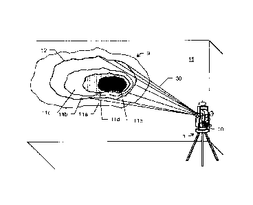
Figure 2 shows a measuring device 1 according to the
invention and an object 15, or the object surface
thereof, a thermal image 10 of which is acquired. On
CA 02822387 2013-06-19
- 21 -
the object 15 itself, a temperature profile 9
corresponding to the thermal image 10 is shown for the
purpose of better illustration. In a spectral range
accessible to the human eye, the object surface would
appear as a homogenous area without conspicuous
features. However, by extending the spectral range that
can be perceived and displayed, it is possible for
further properties of said surface to be visualized.
The temperature profile corresponds to a representation
after image processing performed on a continuous
temperature profile. The formerly continuous (color)
profile is subdivided, by image processing means at the
measuring device, into the zones or ranges lla-e, each
representing a predefined temperature range. The
temperature ranges lla-e are in turn delimited from one
another by in each case a boundary line 12 representing
a specific temperature. By way of example, such an
isotherm 12 is illustrated between the ranges lla and
11b. A temperature range embodied by the temperature
zone llb can extend for example from 35 C to 30 C,
wherein a temperature of 30 C is then present along the
isotherm 12 and the temperature zone lla represents the
temperature range of e.g. 30 C to 25 C. Outside the
zone 11a, a temperature of less than 25 C can then
prevail and is not detected any further in accordance
with the detection settings of the thermal imaging
camera 2. By means of the sighting device 4 arranged in
the measuring device 1, furthermore, the position and
the delimitation of a temperature range of interest on
the object 15 can be measured exactly and, in a next
step, be extracted into a CAD model and be transferred
together with the object 15 into a coordinate system.
For this purpose, a measurement beam 30 is guided e.g.
along the isotherm 12 determined in the image 10 and
the distance with respect to the object 15 is
determined constantly with a predetermined point-
to-point resolution. In this case, the measurement beam
30 can be guided automatically, in particular.
CA 02822387 2013--19
- 22 -
Figure 3 shows the temperature profile 9 from figure 2,
wherein the classification of the temperature profile
into temperature ranges lla-e has likewise already been
effected by means of image processing. The temperatures
of the temperature zones lla-e increase toward the
center, that is to say that the zone lla has a
temperature range having lower temperatures than the
zone 11e, representing the range having the highest
temperatures. By means of image processing,
furthermore, the center 13 of the temperature profile
can be determined and e.g. a heat or cold source can
thus be localized. Likewise, it is possible to define
straight lines 14a, 14b which run along a temperature
gradient and run through the center 13 of the
temperature profile. As a result, it is possible e.g.
to perform a measurement along the straight lines 14a,
14b and to localize thereon points having the lowest
and simultaneously points having the highest detected
temperatures. It is thus possible to make statements
about the temperature profile or the extent of one of
the plurality of temperature ranges lla-e, wherein it
is not necessary to measure the entire spatially
detected temperature range lla-e, rather it suffices to
measure e.g. two mutually perpendicular straight lines
14a, 14b which intersect at the center 13.
Figures 4a and 4b each show an exemplary subdivision of
a temperature profile 9 into temperature or thermal
ranges lla-g. In this case, the entire detected
temperature range in figure 4a is subdivided into seven
sub-ranges lla-g, wherein the temperature range in
figure 4b is subdivided only into two sub-ranges 11a-b.
Such a different subdivision of a temperature range can
make the desired information clear, depending on the
requirement. If e.g. a temperature profile 9 is
detected which encompasses a relatively small
temperature difference of e.g. in total 0.5 C, then a
subdivision of this total profile into a plurality of
sub-ranges can make it possible to carry out a
CA 02822387 2013-06-19
- 23 -
differentiation and a classification of temperature
ranges. By contrast, particularly when evaluating a
temperature profile which encompasses a relatively
large temperature range of e.g. 1000C temperature
difference, said profile can be represented in a manner
gradated in fewer ranges in order here, too, to be able
to perform a meaningful differentiation of temperature
zones.
Figure 5 shows three images 20a-c of a building and a
measuring device 1 according to the invention, which
can be used to acquire said images. The first image 20a
shows a daylight recording of the building, wherein
this recording can be acquired both by means of a
camera assigned to the measuring device 1 and having a
spectral detection range corresponding to the human
eye, and by means of a spectrally extended thermal
sensor at the measuring device, in particular by means
of a thermal imaging camera. The edges 21 of the
building, a window 22 and a chimney 23 are visible on
the image 20a. In the second image 20b, by contrast,
sharp edges 21 of the building are no longer visible,
rather the temperature distribution over the front of
the building is represented. This image 20b may have
been acquired by a thermal imaging camera in the
infrared spectral range. The regions of the building
which are represented darker are clearly discernible,
which substantially run along the edges 21 of the
building, around the window 22 and in the region of the
chimney 23 and indicate regions in which a greater
thermal emission is present. In addition, a temperature
conspicuousness 24 can be visualized in the thermal
image recording 20b. Said temperature conspicuousness
24 can indicate that at this location e.g. a heat leak,
caused for example by a defective building insulation,
is present at the building. The heat leak 24 can be
measured on the basis of the image information by means
of the measuring device 1 and the position with respect
to the building can be determined exactly. For this
CA 02822387 2013-06-19
- 24 -
purpose, a measurement beam 30 can be guided along
previously derived isotherms and can measure the latter
with a defined resolution. By extracting isotherms, it
is possible to determine a core region of the
temperature conspicuousness 24 and to transfer it into
a common coordinate system together with the building
coordinates. The precise position of the leak 24
relative to the building can thus be represented with
the aid of a CAD model. Furthermore, a further image
20c can be generated, which shows the building contours
visible from the daylight image 20a together with the
heat leak 24. By superimposing the information derived
from the two images 20a and 20b, the position of the
temperature conspicuousness 24 can be represented
exactly and visually marked by means of a, more
particularly visible, laser beam by the beam being
guided along a reference path corresponding to the
delimitation of the core region of the heat leak 24.
Such a marking can serve for orientation e.g. for
repair work for eliminating the heat leak 24.
Figure 6 shows a measuring device 1 according to the
invention and a construction machine 25 in the terrain
28. The construction machine 25 has a target mark 26,
which can be sighted by the measuring device 1 by means
of a measurement beam 30. According to the invention,
the target mark 26 can furthermore be thermally coded,
that is to say that the target mark 26 can be heated at
least partly to a predefined temperature, for example
to a defined value of between 50 and 100 C, or be
cooled for example to a defined value of between 5 C
and 20 C, such that a thermal radiation defined thereby
emerges from the target mark 26. In particular, the
temperature can be chosen in such a way that a clear
differentiation of temperature-regulated objects from
the environment is possible. Thus, depending on the
outside temperature Or ambient temperature, a
temperature or temperature range suitable for the
respective requirements can be chosen or predefined for
CA 02822387 2013-06-19
- 25 -
the target mark 26. By way of example, given a
prevailing air temperature of 40 C and sunshine, a
temperature range of 100 C to 110 C may be suitable for
the target mark 26, and a target mark 26
temperature-regulated to 30 C may be suitable at -20 C.
The measuring device 1 once again has a thermal imaging
camera which can be used to capture the construction
machine 25 and thus simultaneously the target mark 26
that is temperature-regulated in a known and defined
manner. By means of image processing, in the measuring
device 1, the temperature of the target mark 26 can be
determined and the position thereof with respect to the
detection direction of the camera or with respect to
the sighting direction of the sighting unit can be
derived. By means of the predefined temperature of the
target mark 26, the target mark 26 captured in the
thermal image can be identified at the measuring device
1 according to the invention and, with the assignment
of the target mark 26 to a construction machine 25, the
position of the construction machine 25 can be
determined unambiguously.
For an initializing identification of a target mark 26,
an initialization can be effected by the target mark 26
that is temperature-regulated in a defined manner being
recorded by means of the thermal imaging camera and,
from the recorded image, a temperature or a temperature
range for the target mark 26 can be derived and stored.
In this case, the temperature regulation of the target
mark 26 or of parts thereof can be produced and
maintained by means of a radiant heater assigned to the
target mark. As an alternative thereto, the target mark
26 can be heated to a specific predefined temperature
and a temperature conspicuousness corresponding to that
predefined temperature can be sought by means of image
processing on an acquired thermal image on the part of
the measuring device 1.
CA 02822387 2013-06-19
- 26 -
Figure 7 shows how a plurality of differently
temperature-regulated target marks 26a-e can be
simultaneously assigned to a plurality of objects. In
this case, the marks 26a and 26b are respectively
assigned to a construction machine 25a and 25b. By
means of a constant image analysis of a thermal image
acquired at the measuring station 1 according to the
invention and subsequent image processing, the
movements of the target marks 26a and 26b and thus the
movement of the construction machines 25a and 25b can
be concomitantly tracked in the acquired image and, on
the basis thereof, a compensating alignment of the
measuring station 1 in the direction of the target
marks 26a and 26b can be effected. By means of the
different thermal coding of the marks 26a and 26b, the
latter can be rapidly differentiated from one another
and the sighting direction of the measuring device 1
can thus be aligned rapidly and precisely with the
respective target mark 26a, 26b and a precise
determination of the position of the construction
machine 25a, 25b can be carried out. In addition to the
target marks 26a and 26b on the construction machines
25a and 25b, further target marks 26c-e are positioned
in the terrain 28. In this case, the two marks 26c and
26e are arranged at a respective measurement point in
the terrain 28 and on the building shown. By virtue of
the fact that these two target marks 26c and 26e in
turn appear different on an acquired thermal image, the
corresponding targets can be rapidly differentiated
from the others, the measuring station can be aligned
with them and their position can be determined exactly.
A further target mark 26d shown is arranged on a
measuring rod 41 guided by a user. The target mark 26d
that is temperature-regulated in a defined manner can
in turn be identified on the part of the measuring
station 1 unambiguously by means of the processing of
an acquired thermal image, on which the target mark 26d
is concomitantly captured, and of the temperature
characteristic recorded therein. On the basis of a
CA 02822387 2013--19
- 27 -
direction with respect to the target derived therefrom
and with knowledge of the distance roughly at which the
target is situated and the spatial relationship between
the temperature-regulated target mark 26d and a
reflector 41 on the measuring rod 40, that is to say
the distance between the target mark 26d and the
reflector 41, the reflector 41 can be sighted directly
by the sighting unit of the measuring station 1 and the
precise position of the measuring rod can thus be
determined. In addition, the position of the measuring
rod 40 can be constantly determined on the basis of the
temperature-regulated target mark 26d by means of image
acquisition and image evaluation and the targeting
device of the measuring station 1 can be aligned with
the reflector 41, e.g. a prism. The user of this
measuring system according to the invention is thus
enabled to pace out different measurement points and to
detect the respective positions of the points rapidly
and automatically.
Figure 8 shows two measuring rods 42 each having a
reflector 41, which can be configured e.g. as a prism.
Furthermore, a coding element 29 is in each case
arranged on the measuring rods 42, said coding element
extending over part of the measuring rod 42. On the
coding elements 29, by way of example, two different
forms of a coding 27a and 27b applied thereon are
shown. The coding forms 27a and 27b in this case each
show dark regions on the coding elements 29 which can
be temperature-regulated in a defined manner and can
thus have a defined thermal coding partially or areally
in specific forms 27a and 27b. By way of example, three
thermal struts 27b or a rectangular area 27a or other
geometrical figures can be provided on the coding
elements 29. Using these different coding forms 27a and
27b, it is possible e.g. to facilitate a
differentiation of target marks on a thermal image by
means of image processing. An identification can then
take place no longer solely on the basis of different
CA 02822387 2013-06-19
- 28 -
temperatures of the target marks, but rather
additionally (or alternatively) by means of the
identification of the form 27a and 27b of the
temperature-regulated regions. The target mark
identified in a recorded thermal image on the basis of
the defined temperature and/or form 27a, 27b thereof
can be used together with its position in the thermal
image in various ways. Firstly, an automatic target
tracking of the identified target mark can be effected
and in this case the sighting direction of the
measuring station 1 can be constantly aligned with the
target mark. Such a target tracking on the basis of a
daylight image is described e.g. in EP 2 141 450. In
this case, the measuring station is automatically
aligned with a target and tracks the latter, wherein
the target identification is effected by means of image
processing of a previously acquired image of the
environment. This system supports a target tracking and
target acquisition by means of a laser beam directed
onto a reflector and detected at the measuring device,
in particular when the laser beam lies outside a
detection range and a target tracking cannot be
realized solely on the basis of the detection of a
laser reflection.
According to the invention, for the purpose of target
tracking, a thermal image of a terrain or of an
environment can be acquired, in particular constantly,
and a target mark that is temperature-regulated in a
defined manner can be identified therein by means of
image processing and a target can be tracked by means
of an automatic and constant alignment of the measuring
station according to the invention with the target mark
or in accordance with a movement of the target mark in
the thermal image. Such a target identification and
tracking can be used in particular for supporting an
automatic laser target tracking unit. By virtue of the
additional use of thermal image information, a target
to be sighted, e.g. in the case of an interruption of
CA 02822387 2013--19
- 29 -
the laser light path, can thus be rapidly acquired
anew.
Furthermore, a manual or automatic target seeking can
take place on the basis of the temperature
identification of the target mark by means of image
processing on an acquired thermal image. In addition,
by means of the position of the target mark identified
in the thermal image, high-precision sighting of a
target can take place automatically. For this purpose,
firstly, by means of image processing on the basis of a
temperature that is different with respect to the
environment and/or on the basis of the geometrical form
of the thermal coding, the position of a thermal coding
element 29 can be determined exactly. For a
high-precision sighting e.g. of a prism that is based
thereon, the distance between the thermal coding and
the reflector 41 may be known. This additional
information makes it possible for the sighting unit of
the measuring station to be aligned with the reflector
41 directly manually or automatically and for the
position thereof to be determined exactly.