Note: Descriptions are shown in the official language in which they were submitted.
CA 02830871 2013-09-19
WO 2012/145525
PCT/US2012/034271
A METHOD OF MAPPING RESERVOIR FLUID MOVEMENT USING
GRAVITY SENSORS
Inventors: Carl M. Edwards and Antonius M. Loermans
FIELD OF THE DISCLOSURE
[0001] In one aspect,
the present disclosure generally relates to
methods and apparatuses for acquiring multi-component gravity information
for an earth formation. More particularly, the present disclosure relates to
estimating the movement of fluid in an earth formation using multi-component
gravity information.
BACKGROUND OF THE DISCLOSURE
[0002] Hydrocarbons
in earth formations, such as reservoirs, are
subject to the migration of fluids (oil, water, gas, etc.) over time.
Detecting
and measuring the movement of these fluids may be useful for estimating the
producible hydrocarbon content of an earth formation and improving
hydrocarbon recovery. The hydrocarbon movement may also be used to
estimate the rate of depletion of a reservoir. One way of
estimating
hydrocarbon movement may be through the use of gravity measurements.
However, the use of gravity measurement may be limited by various factors,
including, but not limited to, availability of suitable tools and the
expensive
nature of gravimeters, which may cost tens of thousands of dollars.
SUMMARY OF THE DISCLOSURE
[0003] In aspects,
the present disclosure is related to methods and
apparatuses for acquiring multi-component gravity information for an earth
formation. More particularly, the present disclosure relates to estimating the
movement of fluid in an earth formation using multi-component gravity
information.
[0004] One embodiment
according to the present disclosure includes a
method of acquiring gravity information for an earth formation, the method
comprising: acquiring the gravity information for the earth formation using at
-1-
CA 02830871 2015-08-17
least one gravimeter, the at least one gravimeter being configured to generate
multi-component gravity information.
[0005] Another embodiment according to the present disclosure includes an
apparatus for acquiring gravity information for an earth formation, the
apparatus
comprising: at least one gravimeter configured to generate multi-component
gravity information for the earth formation.
[0005a] Another embodiment according to the present disclosure includes a
method of acquiring gravity information for an earth formation, the method
comprising: acquiring the gravity information for the earth formation using at
least one gravimeter, the at least one gravimeter being configured to generate
multi-component gravity information including horizontal components of
gravitational acceleration.
[0005b] Another embodiment according to the present disclosure includes an
apparatus for acquiring gravity information for an earth formation, the
apparatus
comprising: at least one gravimeter configured to generate multi-component
gravity information for the earth formation including horizontal components of
gravitational acceleration.
[0006] Examples of some features of the disclosure have been summarized
rather broadly in order that the detailed description thereof that follows may
be
better understood and in order that the contributions they represent to the
art may
be appreciated. There are, of course, additional features of the disclosure
that will
be described hereinafter and which will form the subject of the claims
appended
hereto.
-2-
CA 02830871 2015-08-17
BRIEF DESCRIPTION OF THE DRAWINGS
[0007] For a detailed understanding of the present disclosure, reference
should
be made to the following detailed description of the embodiments, taken in
conjunction with the accompanying drawings, in which like elements have been
given like numerals, wherein:
FIG. 1 shows a gravimeter being deployed along a wireline according to
one embodiment of the present disclosure;
FIG. 2 shows a series of gravimeters deployed in a series of boreholes
for one embodiment according to the present disclosure;
FIG. 3 is a flow chart of a method according to one embodiment of the
present disclosure; and
FIG. 4 shows schematic of a processor and its peripherals for processing
the signals from the gravimeter for implementing one embodiment of the method
according to the present disclosure.
DETAILED DESCRIPTION
[0008] The present disclosure
generally relates to methods and apparatuses
for acquiring multi-component gravity information for an earth
-2a-
CA 02830871 2013-09-19
WO 2012/145525
PCT/US2012/034271
formation. More particularly, the present disclosure relates to estimating the
movement of fluid in an earth formation using at least one gravimeter
configured to generate multi-component gravity information. The present
disclosure is susceptible to embodiments of different forms. There are shown
in the drawings, and herein will be described in detail, specific embodiments
of the present disclosure with the understanding that the present disclosure
is
to be considered an exemplification of the principles of the present
disclosure
and is not intended to limit the present disclosure to that illustrated and
described herein.
[0009] Herein, the term "information" may include, but is not limited
to, one or more of: (i) raw data, (ii) processed data, and (iii) signals. A
"gravimeter" may be any device configured to estimate acceleration due to the
gravitational properties of matter. The at least one gravimeter may include a
vector gravimeter. A "vector gravimeter" may be any device configured to
estimate the vector components of acceleration due to gravitational properties
of matter. A vector gravimeter may be formed using three single axis
gravimeters with linearly independent orientations.
[0010] The at least one gravimeter may be deployed at the surface of
or within the earth formation in or near a volume of interest. The gravimeter
may be configured for temporary or permanent deployment. The volume of
interest may be a hydrocarbon reservoir. In some embodiments, the at least
one gravimeter may include multiple vector gravimeters positioned in one or
more boreholes penetrating an earth formation. During the deployment of the
gravimeter, the orientation of the gravimeter, with respect to a global
coordinate system, may be measured using a vector magnetometer or other
equivalent device known by those of skill in the art. The gravimeter
orientation may be measured by noting the direction of the earth's magnetic
field and the local gravity vector with respect to the gravimeter's local
coordinate system. The gravimeter may be in communication with the
reservoir rock for the duration of a monitoring project. In some embodiments,
one or more surface gravimeters may be used with a gravimeter located
-3-
CA 02830871 2013-09-19
WO 2012/145525
PCT/US2012/034271
downhole. In other embodiments, all gravimeters may be located at the
surface.
[0011] Measurements taken by each gravimeter may include multi-
component gravity vectors. In some embodiments, the multi-component
gravity measurements may be taken at different times, thus providing a log of
the gravity vector including measurements for each vector component. This
log may provide a record of how the gravity vectors at a specific position
change from one time to another. By subtracting the gravity vectors at a first
time from the gravity vectors at a second time, discrete differences in the
gravity vectors may be estimated for each vector component. A "discrete"
difference relates a difference between vectors where each vector component
is independently estimated (such as with a multi-component gravimeter). A
discrete difference may be contrasted with a calculated difference in that a
discrete difference involves estimating each vector component for each
dimension of a multi-dimensional vector and a calculated difference involves
deriving vector components using the direction and magnitude of a single
multi-dimensional vector. For example, using a multi-component gravimeter
allows the subtractions of sets of multi-component vectors for estimating
differences, where each vector component has been discretely measured by the
gravimeter. The use of multi-component gravimeters may be advantageous
where the vector gravimeter may need to be more sensitive along an axis of
one or more vector components than the axis of another vector component.
For example, in a mostly horizontal slab of a formation, a gravimeter
positioned at a depth within the slab may require higher sensitivity to
horizontal changes in gravity than vertical changes.
[0012] The set of multi-component gravity vector differences may be
used to estimate a change in density of the earth formation and/or a change in
total mass of the volume of interest. The changes in density and/or total mass
may be estimated using an inversion, a forward modeling equation, or other
well known techniques for the change in density/total mass within the earth
formation. The density/total mass changes may be interpreted to map spatial
changes to the volume of interest's fluid content. These maps may be used to
-4-
CA 02830871 2013-09-19
WO 2012/145525
PCT/US2012/034271
make production decisions and improve the total amount of hydrocarbons
recovered from the volume of interest.
[0013] In some embodiments, the multi-component gravity vector
measurements may be transformed from the sensor coordinate system to the
global coordinate system and compensated for known natural phenomena,
including time-varying phenomena. Known time-varying natural phenomena
may include, but are not limited to, earth tides. Other natural phenomena may
include acute events including, but not limited to, volcanism and seismic
events. Compensating for known phenomena may increase accuracy of the
gravity information for the volume of interest.
[0014] Additionally, gravity vector accuracy may be improved by
reducing the distance between the gravimeter and the volume of interest in the
earth formation may increase sensitivity of the gravimeter to changes in
density/total mass and spatial resolution of the multi-component gravity
information. Positioning at least one gravimeter downhole may improve the
proximity of the gravimeter to the volume of interest when the volume of
interest is located below the surface of the earth. The quality of the gravity
information may also be improved by deploying multiple gravimeters in
boreholes and/or at the surface. The improved sensitivity and resolution of
vector gravimeters deployed downhole may reduce the total number of
gravimeters used to monitor a given reservoir.
[0015] When vector gravimeters remain located in substantially the
same position between the times of gravity measurements, vector components
of gravity at the gravimeter position may be estimated. However, when a
gravimeter has been moved (even if it is then moved back to the same
location) between times of gravity measurements, only the magnitude of the
gravity vector may be estimated, not the components of the gravity vector.
Herein, the term "position" refers to depth, location, and / or orientation.
When a gravimeter is permanently placed in the earth formation or on the
surface above the earth formation, the reference coordinate system exists for
estimating components of the gravity vector at the gravimeter. Herein the
-5-
CA 02830871 2013-09-19
WO 2012/145525
PCT/US2012/034271
term "permanent" relates to the gravimeter retaining the same depth, location,
and orientation between relevant gravity measurements periods.
[0016] Vector gravimeters may be installed in boreholes located in or
near a volume of interest and, further, may be installed in such a manner so
that the orientation of the gravimeter's coordinate system is known with
respect to a reference coordinate system. The reference coordinate system
may be global to the extent of a region or volume of the earth that contains
the
hydrocarbon reservoir. For example, the reference coordinate system might be
x, y, z <=> North, East, Down, (1)
where down is defined as the initial direction of gravity at the time of
installation; north is defined as the direction of the Earth's magnetic field
that
is perpendicular to the initial direction of gravity; and east is defined as
the
direction perpendicular to down and north. The orientations of the vector
gravimeters with respect to the reference coordinate system may be stored for
later use.
[0017] Estimates of the gravity vectors may be made periodically at
all
sensor stations equipped with gravimeters. The estimates may then be
transformed from the sensor coordinate system to the reference coordinate
system. Changes in the vector components in the transformed measurements
may then be used to estimate changes in the reservoir's fluid distribution
using
well-known inversion and/or forward modeling techniques.
[0018] When used with vector gravimeters as permanent sensors, the
local coordinate system may remain fixed in orientation to the global
coordinate system. Thus, if the orientation of each sensor with respect to the
global coordinate system is known initially, then it is known for the duration
of the measurement of the gravity components. The components of the
gravity vector may then be transformed for the local coordinate system of the
sensor to the global coordinate system and changes in these components may
be used to model changes in the fluid distribution within the earth formation.
-6-
CA 02830871 2013-09-19
WO 2012/145525
PCT/US2012/034271
[0019] If g' is the gravity vector in the gravimeter's local
coordinate
system and 113' is the earth's magnetic field vector transformed to the
gravimeter's local coordinate system, then the unit vectors for the global
reference system may be defined in the gravimeter's local coordinate system
by the following transformations:
= I /Ill;
y'G = x b' / 1bl ; (2)
xG = yG xzG
In eqn. (2), the primes represent the vectors in the gravimeter's local
coordinate system. The DCM rotation matrix may be given by
r
' ( ) ( 1YZ(G)N' GIN' GIN'
R = (I: ) , (ST' )(i: ) , = (3)
(I' )(YG
G z' Z' G Z' i
[0020] The elements of R may be the direction cosines between the
global coordinate system unit vectors and the local coordinate system unit
vectors. Using the DCM, the gravity vector in the local frame of the
gravimeter may then be transformed to the global coordinate system by
g = Wig' . (4)
[0021] This transform is valid for all subsequent measurements by the
gravimeter assuming that the gravimeter remains substantially fixed in the
earth formation. The substantially fixed position of the gravimeter in the
earth
formation may be subject to movement due to tectonic activity; however,
tectonic induced movement is generally small compared to the typical
movement of fluid fronts in hydrocarbon reservoirs. Further, the formation
may tend to move as an entire unit, which may minimize changes in the
gravity vector due to tectonic movement. Also, the gravimeter may be subject
-7-
CA 02830871 2013-09-19
WO 2012/145525
PCT/US2012/034271
to the change of direction of the earth's magnetic field over the earth's
surface.
These changes in direction may result in a slight distortion of the fluid
distribution changes estimated by the gravimeter. Generally these distortions
not large enough to be substantial relative to fluid movements. If the
distortion were to prove to be too large, then another coordinate
transformation may be performed to account for the distortion. Finally, the
gravimeters might move because of reservoir compaction and subsidence.
Compaction may be caused by a reduction in pore pressure during
hydrocarbon recovery from the earth formation. For many oil reservoirs,
especially where pressure maintenance is performed via water injection, the
reduction in pore pressure is small over the lifetime of the reservoir. Thus,
in
most cases, compaction and subsidence would only be a small perturbation on
the modeled fluid distributions.
[0022] Let gg (ti) be
the gravitational vector measured in the reference
frame of the sensor at r, , as measured in the global frame, and at time tj .
The
gravitational vector may be adjusted to account for any time varying effects,
such as earth tides. This measurement may be transformed to the global
reference frame by the transform, R1, which may be determined at the time
each sensor is placed in the reservoir. Then eqn. 4 may be expressed as
g, (tf ). (5)
The time-lapse difference in the vectors may be found by subtraction.
Ag, g, (t)¨g, (0) (6)
[0023] The time, t =
0, may be some time after all the sensors have
been positioned in and/or on the earth formation. Indeed, this time, t = 0,
may
be arbitrary, and the difference could be formed using data from any two
different times.
[0024] The
gravitational vector may be estimated from the Newton's
law of gravitation:
P (ro
g, ¨Gfcrro (ro r, ) , (7)
¨
-8-
CA 02830871 2013-09-19
WO 2012/145525
PCT/US2012/034271
where the integral is over all space (or at least over all nearby space
including
the earth and its atmosphere). The contributions from massive bodies farther
from earth have been accounted for by previously adjusting the data for earth
tides and other effects. The volume of integration may be divided into two
parts for the purposes of mapping reservoir fluid movement. Thus,
gi = g, ¨ G d3r P(r )3 (ro , (8)
Reservoir 11.0 1;1
where g, may be the background acceleration caused by all mass outside the
reservoir, which may be assumed to be constant. The density of the reservoir's
material, p, is time dependent. Thus when the difference is formed,
(
Agi = ¨G d3r0(6,p(ro))ro '
Reservoir 11.0
(9)
Ap(r0)=p(r0,t)¨p(r0,0).
[0025] The change in the density within the earth formation may be
related directly to the change in saturation as the hydrocarbons are being
produced from a reservoir within the earth formation.
Ap(ro), E 0(ro)Asn, (ro) pm;
m=o,w,g (10)
ASm (ro) = Sm (ro , t)¨ Sm (ro , 0).
where 0 is the porosity of the earth formation; Sm is the fluid saturation;
and
Pm is the bulk fluid density; the subscripts o, w, g, represent oil, water and
gas, respectively. The problem of mapping fluid front movement translates
directly into mapping changes in density within the reservoir. The estimation
may be subject to simplifying assumptions such as, for the many cases,
assuming that are only changes in two fluids in the earth formation. For
example, if the two fluids are oil and water, then
Ap (ro)= 0 (ro)ASw (ro)(pw¨ po). (11)
Another simplifying assumption could be assuming the porosity is constant
throughout the reservoir.
-9-
CA 02830871 2013-09-19
WO 2012/145525
PCT/US2012/034271
[0026] Thus eqn. (9)
may be solved for Apf ) , as is common for
time-lapse surface gravity surveys, and a variety of techniques are available.
In addition, joint inversion of combined borehole and surface gravity
measurements may also be performed. In the case of a joint inversion, the
reservoir may be divided into K voxels or cells. If ro,k is the vector to the
kil,
cell and Mk = Ap (ro,k) is density difference in that cell, then the
contribution
to the gravity vector as measured by the ith sensor from the kil, voxel is
Ag
r
( + s ¨ ) z õ = ¨GA,ok (ro ) d3s 0,
k
(12)
kthvoxel IrO,k s ¨ r 13
The integral in eqn. (12) depends only on ro,k and ri . Thus
Ag (Qz )ik ;
+ s ¨ ) (13)
(Qz )ik = d3s ( 0,k
=
kthv xel 111,k S ¨1'113
Agz,, is a vertical component of the gravity vector; (Qz )ik is a real number.
Thus, eqn. (9) may become
yz = QzAp;
yz = (Agz,,,Agz,,,= = =, Ag ) ;
Ap = (Ap,, Ap2, = = = , ApK )T ; (14)
Qzu = = = Qz1K
Qz = := := =
\Qz.N1 = = = Q zATK
[0027] Density
changes in the voxels may be solved using inversion
techniques or other techniques known to those of skill in the art. If vector
differences are used, then there are 3N measurements instead of N
measurements. Then the model to be inverted becomes
-10-
CA 02830871 2013-09-19
WO 2012/145525
PCT/US2012/034271
= QAp;
\T
= (Ag,,,,Agx,2,= = =, Ag ,,,,Agy,1,Ag y,2, = = = , Agy,,Agz,,,Agz,2,= = =,
Ap = (Apt , Ap2, = = = , Ap, )T ;
4`)x
Q= Q ;
(15)
(ro k +s¨r.)
(Qcjik = ¨Ga d3 s ' 3 ;a E
kthvoxel IrO,k
A,ok (ro )a d3s (r 'k s rl )
= ¨G
3 ;aE {514,4.
kthvoxel IrO,k +s¨rd
Eqn. (15) may be solved by any number of techniques known to those of skill
in the art, including least-squares analysis.
[0028] It is important to recognize that the magnitude of the gravity
vector as a whole is not sensitive to changes in density in the same
horizontal
slab of the reservoir as the measurements. The vertical component may be
almost completely insensitive to fluid movement in the reservoir. However
the horizontal component may be much more sensitive to the gravity changes
due to fluid movement. Once the changes in density of the voxels in the
reservoir are determined, they may be interpreted as images of changes to the
fluid distribution or content within the reservoir by applying eqn. (10). The
resultant maps of fluid distribution may then be used to make production
decisions and improve the total amount of hydrocarbons recovered from the
reservoir.
[0029] Benefits of the proposed methods and apparatuses may include
multi-component estimates for gravitational acceleration, increased
sensitivity
and resolution for earth formation density and density changes, and more
accurate fluid movement estimates in hydrocarbon reservoirs. One non-
limiting embodiment of an apparatus configured to use the proposed technique
is described below.
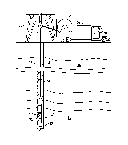
[0030] FIG. 1 shows one embodiment according to the present
disclosure wherein a cross-section of a subterranean formation 10 in which is
-11-
CA 02830871 2013-09-19
WO 2012/145525
PCT/US2012/034271
drilled a borehole 12 is schematically represented. Suspended within the
borehole 12 at the bottom end of a non-rigid carrier such as a wireline 14 is
bottom hole assembly (BHA) 40. The BHA 40 may include a gravimeter 100.
The wireline 14 may be carried over a pulley 18 supported by a derrick 20.
Wireline deployment and retrieval is performed by a powered winch carried
by a service truck 22, for example. A control panel 24 interconnected to the
gravimeter 100 through the wireline 14 by conventional means controls
transmission of electrical power, data/command signals, and also provides
control over operation of the components in the gravimeter 100. In some
embodiments, the borehole 12 may be utilized to recover hydrocarbons. In
other embodiments, the borehole 12 may be used for geothermal applications
or other uses. In some embodiments, the gravimeter 100 may also be located
on the surface, near the top of the borehole 12. The BHA 40 may also include
a vector magnetometer 110.
[0031] The vector gravimeter 100 may be a multi-component device
with a predetermined orientation, such as an angular orientation. The
gravimeter 100 may, in a non-limiting embodiment, have three single axis
gravimeters with sensitive axes configured to be at least linearly
independent.
In some embodiments, the sensitive axes may be configured to be mutually
orthogonal. The gravimeter 100 may also include control electronics. The
control electronics may be in the borehole or at a surface location. Single
axis
gravimeters must be oriented so that the sensitive axis is parallel to the
gravity
vector and usually require complicated mechanical mechanisms as well as
leveling procedures. In contrast, the vector gravimeter 100 does not have to
be oriented in any particular manner to measure the length of the gravity
vector.
[0032] The gravimeter 100 may provide components of the gravity
vector that may be known under that local coordinate system of the
gravimeter, however, this information may not be usable with the orientation
of the local coordinate system with respect to a global reference system, or
at
least a reference system that is valid over a region or volume that includes
the
earth formation, is unknown.
-12-
CA 02830871 2013-09-19
WO 2012/145525
PCT/US2012/034271
[0033] In some embodiments, the BHA 40 may be configured to
deploy the gravimeter 100 within the borehole 12 to a fixed position. Here,
the gravimeter 100 may be detachable from the BHA 40. The precise position
of the gravimeter 100 may be estimated using methods well known within the
hydrocarbon production community. An example would be to use the depth
as measured along the borehole in combination with data from a well survey.
At the selected depth, the gravimeter 100 may be positioned against the
borehole wall 12, such as by a mechanism like a hydraulic cylinder, and
attached to the earth formation or borehole casing by some method known to
those skilled in the art of permanent sensing.
[0034] The vector magnetometer 110 may be used to estimate the
direction of the earth's magnetic field relative to the BHA 40. When the
gravimeter 100 is attached to the BHA 40, the alignment of the BHA's local
coordinate system may be aligned with the gravimeter's local coordinate
system. In some embodiments, differences between the two local coordinate
systems may be quantified and noted. For example, the BHA 40 may be
designed such that its local axes are coincident with the local axes of the
gravimeter, or more precisely that the direction cosine matrix (DCM) is the
identity matrix for the transformation between the local coordinate systems.
Those skilled in the art will recognize that any number of local coordinate
systems may be used. The magnetometer may have its own local coordinate
system along with the gravimeter and the deployment tool. Indeed, these
coordinates systems need not be precisely aligned; rather all that is
necessary
is that the DCM between each coordinate system be known. For the sake of
simplicity in this example, it may be assumed that each DCM is an identity
matrix.
[0035] A measurement of the gravity vector may be made by the
gravimeter 100 before the attachment mechanism is retracted into BHA 40.
Additionally, a measurement of the earth's magnetic field may be made by the
vector magnetometer 110.
[0036] FIG. 2 illustrates a representative placement of vector
gravimeters in or near a hydrocarbon reservoir 200 in the earth formation 10.
-13-
CA 02830871 2013-09-19
WO 2012/145525
PCT/US2012/034271
In this example, the center borehole 222 is an injector well and the outer
boreholes 12, 232 are producer wells. Each borehole 12,222,232 is shown
with four vector gravimeters 12a-d, 222a-d, 232a-d placed in or near the
reservoir 200. In other embodiments, one or more of the boreholes may be
deviated or horizontal instead of vertical. The selected positions of the
sensors
12a-d, 222a-d, 232a-d may not be critical as long as the positions are known
to the normal precision of well logging and remain substantially fixed over
the
duration of the monitoring of the reservoir 200.
[0037] As shown in
FIG. 3, one embodiment includes a method 300
according to the present disclosure for acquiring gravity information using
gravimeter 100. Method 300 includes step 310, where the gravimeter may be
positioned in the borehole 12. In step 320, the position information for the
gravimeter may be recorded. Position information may include location
(relative or global position), depth, and orientation (geographical, magnetic,
etc.). In step 330,
the vector gravimeter 100 may generate signals
corresponding to gravitational acceleration for each of the vector components
of gravity in the earth formation 10. In step 340, the signals may be
transmitted to a processor configured to convert the signals into multi-
component gravitational information. In step 350, the multi-component
gravitational information may be modified to compensate for known
phenomena. Known phenomena may include time varying events, such as
earth tides, and acute events, such as volcanism and seismic disturbances. In
step 360, density and/or total mass changes in the earth formation may be
estimated using the multi-component gravity information. The estimation of
the density/total mass changes may include a mathematical operation, such as,
but not limited to, an inversion or a forward modeling. In step 370, the
movement of fluid in the earth formation may be estimated using the estimated
density changes. In some embodiments, step 350 may be optional. In some
embodiments, step 360 may be omitted and fluid movement may be estimated
directly from step 350. In some embodiments, steps 360 and 370 may be
optional. In some embodiments, steps 330 and 340 (and optional steps 350,
360 and 370) may be repeated without repeating steps 310 and 320.
-14-
CA 02830871 2013-09-19
WO 2012/145525
PCT/US2012/034271
[0038] As shown in FIG. 4, certain embodiments of the present
disclosure may be implemented with a hardware environment that includes an
information processor 400, an information storage medium 410, an input
device 420, processor memory 430, and may include peripheral information
storage medium 440. The hardware environment may be in the well, at the
rig, or at a remote location. Moreover, the several components of the
hardware environment may be distributed among those locations. The input
device 420 may be any data reader or user input device, such as data card
reader, keyboard, USB port, etc. The information storage medium 410 stores
information provided by the detectors. Information storage medium 410 may
include any non-transitory computer-readable medium for standard computer
information storage, such as a USB drive, memory stick, hard disk, removable
RAM, EPROMs, EAROMs, flash memories and optical disks or other
commonly used memory storage system known to one of ordinary skill in the
art including Internet based storage. Information storage medium 410 stores a
program that when executed causes information processor 400 to execute the
disclosed method. Information storage medium 410 may also store the
formation information provided by the user, or the formation information may
be stored in a peripheral information storage medium 440, which may be any
standard computer information storage device, such as a USB drive, memory
stick, hard disk, removable RAM, or other commonly used memory storage
system known to one of ordinary skill in the art including Internet based
storage. Information processor 400 may be any form of computer or
mathematical processing hardware, including Internet based hardware. When
the program is loaded from information storage medium 410 into processor
memory 430 (e.g. computer RAM), the program, when executed, causes
information processor 400 to retrieve detector information from either
information storage medium 410 or peripheral information storage medium
440 and process the information to estimate a parameter of interest.
Information processor 400 may be located on the surface or downhole.
[0039] Further, while FIG. 1 shows an embodiment deployed using a
wireline 14. Embodiments of the present disclosure may be deployed via a
-15-
CA 02830871 2013-09-19
WO 2012/145525
PCT/US2012/034271
carrier that includes, but is not limited to rigid carriers, non-rigid
carriers,
coiled tube, casing, liners, drill pipe, wirelines, wireline sondes, slickline
sondes, c-lines, drop tools, self-propelled tractors, etc. The term "carrier"
as
used herein means any device, device component, combination of devices,
media and/or member that may be used to convey, house, support, or
otherwise facilitate the use of another device, device component, combination
of devices, media and/or member.
[0040] While the foregoing disclosure is directed to the one mode
embodiments of the disclosure, various modifications will be apparent to those
skilled in the art. It is intended that all variations be embraced by the
foregoing disclosure.
-16-