Note: Descriptions are shown in the official language in which they were submitted.
CA 02831952 2013-09-30
WO 2012/145583
PCT/US2012/034378
BOREHOLE TO SURFACE ELECTROMAGNETIC TRANSMITTER
BACKGROUND OF THE INVENTION
1. Field of the Invention
[00011 The present invention relates to an electromagnetic energy source or
transmitter for
borehole to surface electromagnetic surveying and mapping of subsurface
formations.
2. Description of the Related Art
[0002] Electromagnetic methods to obtain data regarding subsurface earth
formations and
their constituent fluid contents have been used for several purposes. Among
these have been
petroleum reservoir characterization and front-tracking in enhanced oil
recovery operations.
[0003] One of these electromagnetic methods has been what is known as the
borehole-
surface or borehole to surface electromagnetic method (BSEM). Two electrodes
have been
used in the borehole-surface electromagnetic energy method. The first
electrode has been in
a well = borehole of what is known as the transmitter well, transmitting
electromagnetic
energy, and the other, which may be a ground electrode, has been at the
earth's surface along
with a receiver array. The receiver array has been located at spaced positions
on the surface
conforming to the reservoir of interest to detect the energy field after
passage through the
earth from the first or transmitter electrode.
[0004] In a typical operation, Borehole to Surface Electromagnetic (BSEM)
utilized an
electromagnetic source in the borehole and an array (typically 600-2000 or
more) of receivers
on the surface, thus allowing the mapping of the fluid (typically oil and
water) distribution in
-1-
CA 02831952 2013-09-30
WO 2012/145583
PCT/US2012/034378
large areas of the reservoir a few (2-4) kilometers away from the well in
which the transmitter
electrode had been positioned.
[0005] The transmitter electrode located in the well was activated at depths
of interest. The
signal emitted on activation could be a single frequency or multiple
frequencies. The
resultant electromagnetic field which then occurred was sensed in the time and
frequency
domains by the receiver array. Surveys of this type could then be repeated
after passage of a
period of time from the transmitter well to track the subsurface fluid
migration.
[0006] An interface in a subsurface formation between solids and liquids
produces induced
polarization and frequency scattering responses to the emitted signals and the
responses were
received and recorded. The recorded data was processed and analyzed to map
boundaries of
subsurface reservoirs of interest and evaluate =other nearby formations. The
information
obtained was important in assessing the sweep efficiency, or the percentage of
original oil
displaced from a formation by a flooding fluid, and in locating potential
bypassed oil zones,
thus ultimately increasing oil recovery.
[0007] So far as is known, no provision has been made to obtain a precisely
accurate
measurement of the depth position of the transmitter downhole. An indirect
measurement was
possible only from measurements of the length of cable passing from the cable
reel or drum
in the wireline truck into the well. However, this length measurement did not
take into
account elongation of the cable at increasing depths in the well. This gave
rise to an inability
to accurately determine well depth measurements of formations and correlate
actual depth of
the transmitter emissions of energy with data representative of subsurface
conditions.
[0008] During B SEM surveying, other well logging operations with other well
logging tools
present in the well borehole were not, so far as is known, conducted. =The
purpose of this was
so that the transmitter electrode could be easily moved to desired depths in
the well. Thus,
-2-
CA 02831952 2013-09-30
WO 2012/145583
PCT/US2012/034378
there was no capability to monitor down. hole well conditions during the BSEM
survey. Thus,
so far as is known, no provision was made to detect incipient abnormal
conditions which
might provide advance notice of one or more of possible problems, such as
overheating of the
transmitter electrode, starting of an ignition in the well, a gas kick,
=overpressure, or the like.
SUMMARY OF THE INVENTION
[00091 Briefly, the present invention provides a new and improved
electromagnetic energy
transmitter mounted with a wireline for electromagnetic surveys of subsurface
earth
formations from a well borehole which has a casing installed along its extent
into the earth to
a location near a formation of interest, the casing being formed of lengths of
tubular members
connected at end portions to adjacent tubular members by casing collars.
The
electromagnetic energy transmitter includes an electromagnetic energy source
emitting
electromagnetic energy in the form of electric current when activated, and a
control circuit
activating the conductive bar to emit electromagnetic energy for a selected
time and duration.
The electromagnetic energy transmitter also includes a sonde body housing the
control
circuit. The sonde body is adapted to be lowered by the wireline in the well
borehole to the
location near the formation of interest. An upper connector subassembly is
mounted above
the sonde body connecting the control circuit to the wireline and permits the
flow of electrical
current to the electromagnetic energy source. A lower connector subassembly is
mounted
below the sonde body and connects the electromagnetic energy source to the
control circuit.
The electromagnetic energy transmitter also includes a casing collar locator
mounted in the
sonde body to provide indications of movement of the sonde body past casing
collar in the
casing during movement of the transmitter through the well borehole. The
electromagnetic
energy transmitter further includes a fluid pressure sensor mounted in the
sonde body for
measuring= fluid pressure in the well borehole at the location of the sonde
body; and a
-3-
CA 02831952 2015-04-20
=
temperature sensor mounted in the sonde body for measuring temperature in the
well borehole
at the location of the sonde body.
[0010] The present invention also provides a new and improved method of
electromagnetic
surveying subsurface earth formations from a well borehole which has a casing
installed along
its extent into the earth to a location of interest near a formation of
interest, the casing being
formed of lengths of tubular members connected at end portions to adjacent
tubular members
by casing collars. According to the present invention electromagnetic energy
source with a
sonde body connected therewith is lowered to the location of interest in the
borehole. A
measure is formed with the casing collar locator of the number of casing
collars past which
the source and sonde body travel during the step of lowering to determine the
depth of the
source and sonde body in the borehole based on the measured number of casing
collars. The
casing collar locator is then deactivated when the source and the sonde body
are at the
location of interest. Electromagnetic energy is =then emitted from the source
at the location of
interest to travel through the subsurface formations for electromagnetic
energy surveying of
the subsurface earth formations.
[0010A] The present invention also provides a borehole to surface
electromagnetic survey
apparatus for conducting borehole to surface electromagnetic surveys of
subsurface earth
formations from a well borehole with electromagnetic field responses sensed by
an array of
receivers at the earth surface as a result of electric current flow from a
transmitter, the
borehole having a casing installed along its extent into the earth to a
location near a formation
of interest, and the casing being formed of lengths of tubular members
connected at end
portions to adjacent tubular members by casing collars. The electromagnetic
survey apparatus
includes an electromagnetic energy transmitter which is comprised of a
conductive bar
emitting electromagnetic energy in the form of electric current to travel
through the earth
from the well borehole through the subsurface formations when activated, a
control circuit
activating the conductive bar to emit electric current for a selected time and
duration, and a
sonde body housing the control circuit and being lowered by a wireline in the
well borehole
-4-
CA 02831952 2015-01-23
.=
to the location near the formation of interest. The conductive bar is mounted
to the sonde
body below the sonde body. An upper connector subassembly is mounted above the
sonde
body connecting the control circuit to the wireline and permitting the flow of
electrical current
to the conductive bar. A lower connector subassembly below the sonde body
connects the
conductive bar to the control circuit. A casing collar locator is mounted in
the sonde body and
provides indications of the movement of the sonde body past casing collar in
the casing
during movement of the transmitter through the well borehole. A fluid pressure
sensor is
mounted in the sonde body for measuring fluid pressure in the well borehole at
the location of
the sonde body during the borehole to surface electromagnetic surveys. A
temperature sensor
is mounted in the sonde body for measuring temperature in the well borehole at
the location
of the sonde body during the borehole to surface electromagnetic surveys. The
electromagnetic survey apparatus further includes a receiver array comprised
of a plurality of
electromagnetic energy receivers located at spaced positions on the earth over
a surface area
to detect the electromagnetic field response resulting from electric current
travel from the
transmitter to the surface for electromagnetic energy surveying of the
subsurface earth
formations.
BRIEF DESCRIPTION OF THE DRAWINGS
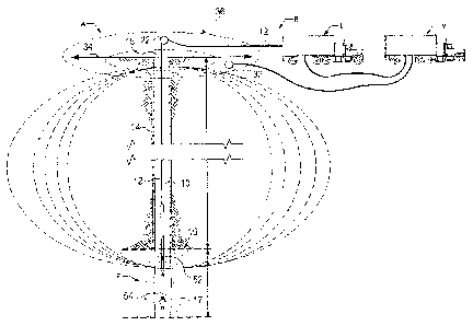
[0011] Figure 1 is a schematic diagram, taken partly in cross-section, of a
borehole to surface
electromagnetic survey system disposed in a well borehole to obtain borehole
to surface
electromagnetic survey data according to the present invention.
[00121 Figure 2 is an enlarged view of a portion of the well casing of the
structure illustrated
in Figure 1.
[0013] Figure 3A is a schematic diagram of an upper portion of a borehole to
surface
electromagnetic transmitter according to the present invention.
-4A-
CA 02831952 2013-09-30
WO 2012/145583
PCT/US2012/034378
[0014] Figure 3B is a schematic diagram of an intermediate portion of a
borehole to surface
electromagnetic transmitter according to the present invention.
[0015] Figure 3C is a schematic diagram of a lower portion of a borehole to
surface
electromagnetic transmitter according to the present invention.
[0016I Figure 4 is an example display of well log data from conventional well
logs regarding
subsurface formations as a function of depth in a well borehole.
[0017] Figure 5 is a plot of induced polarization data obtained from
subsurface formations
over a=range of depths during borehole to surface electromagnetic surveying
and mapping of
subsurface formations adjacent the well borehole in which the well log data of
Figure 4 was
obtained.
[0018] Figure 6 is a plot of induced polarization data obtained from
subsurface formations
over a different range of depths than Figure 5 during borehole to surface
electromagnetic
surveying and mapping of subsurface formations adjacent the well borehole in
which the well
log data of Figure 4 was obtained.
DETAILED DESCRIPTION OF THE PREFERRED EMBODIMENTS
[0019] In the drawings, a borehole to surface electromagnetic (BSEM) survey
system B is
shown schematically in Fig. 1 in connection with a well borehole 10 which has
been drilled
into the earth through rock in subsurface earth formations F having
hydrocarbon fluids of
interest. An electromagnetic energy transmitter T (Figures 3A, 3B and 3C)
according to the
present invention is mounted with a wireline 12 for electromagnetic surveys of
the subsurface
earth formations F from the well borehole 10. As is typical, the well borehole
10 has a casing
14 (Figures 1 and 2) installed along its extent into the earth to a location
near a reservoir. A
typical casing string 14 extends several thousands of feet from wellhead 15 at
or above
-5-
CA 02831952 2013-09-30
WO 2012/145583
PCT/US2012/034378
ground level to a lowermost casing section or casing shoe 16 within the
wellbore 10. Below
the depth of the casing shoe at 16, the lower portion of the well where no
casing is present is
what is known as open hole 17.
10020] The casing 14 is formed of lengths of tubular joint members 18 (Figure
2) connected
at upper and lower end portions 18a and 18b to adjacent tubular members 18 by
casing
collars 20. The ends of each tubular joint or segment 18 of casing string 14
are externally
threaded, and the collars 20 are internally threaded to mate with the threaded
portion of the
adjacent casing members 18. As is conventional, where two pieces of casing
pipe 18 are=
joined with a collar 20, there may in some wells be a small gap between the
adjacent ends of
the two sections of casing. Alternatively, in what is known as "flush joint"
casing, no gap is
present between the ends of adjacent casing member sections which are held in
abutting
relationship by collar 20.
[0021] In connection with borehole to surface electromagnetic (BSEM) surveys,
the
transmitter T and wireline cable 12 are suitably supported at the wellhead 15
such as by a
= sheave wheel 22, which is used to raise and lower the transmitter T in
the wellbore 10.
During the borehole-surface or borehole to surface electromagnetic surveys,
two electrodes
are used. A first electrode 30 (Figure 3B) of the transmitter T according to
the present
invention is in the well borehole 10, which serves as the transmitter well to
transmit
electromagnetic energy of desired frequency and amplitude into earth
formations around the
well borehole for travel through the subsurface earth formations F. The other
electrode 32
(Figure 1), which may be a ground electrode, is at the earth's surface 34
along with a receiver
array A indicated schematically in Figure 1. The receiver array A is composed
of
electromagnetic energy receivers 36 located at spaced positions on the earth
over a surface
area conforming to dimensions of a reservoir of interest.= Receivers in the
receiver array A
-6-
CA 02831952 2013-09-30
WO 2012/145583
PCT/US2012/034378
detect the transmitted energy field after passage through the earth from the
transmitter
electrode T. A borehole to surface electromagnetic survey allows mapping of
the fluid
(typically oil and water) distribution in large areas of the reservoir a few
(typically 2-4)
kilometers away from the well in which the transmitter electrode had been
positioned.
Parameters of interest in such a survey are resistivity and induced
polarization or IP, as will
be set forth.
[0022] The transmitter electrode T located in the well 10 is activated at
depths of interest.
The resultant electromagnetic field is sensed in the time and frequency
domains by the
receiver array A. Surveys of this type are repeatable at required intervals
over a period of
time to track migration of subsurface fluids.
[0023] The electromagnetic energy transmitter T includes a conductive metal
bar or rod 40 of
copper or other similar conductive material. The conductive electrode energy
source 40 is
operatively connected to a control circuit 42 which responds to control
signals sent from the
surface from a transmitter vehicle V at the surface over the wireline 12 and
activates the
conductive electrode 40 to emit electromagnetic energy of the desired
frequency and
amplitude for a selected time and duration during BSEM surveying.
[0024] According to the present invention, the borehole depths at which the
BSEM survey
electromagnetic energy is emitted by the transmitter T during surveys are
obtained in a
manner to be set forth. The borehole depth readings are recorded along with
the sensed
electromagnetic fields corresponding to emissions at that depth in a suitable
data memory in a
computer or data processor in a logging vehicle or truck L (Figure 1). Once
recorded, the
BSEM data and depth measurements are transferred as needed into the data
processing
system or computer for on site processing and analysis and are available for
further
processing and analysis elsewhere. Records of the time and content of the
electromagnetic
-7-
CA 02831952 2013-09-30
WO 2012/145583
PCT/US2012/034378
energy specified by control signals are also furnished from the transmitter
vehicle V to data
recoding computer or processor equipment in the logging vehicle or truck L.
[0025] The electromagnetic energy transmitter T also includes a sonde body 44
(Figure 3A
and 3B) connected to the wireline 12 by an upper connector subassembly 46. The
transmitter
T is adapted to be lowered by the wireline 12 in the well borehole 10 to the
various depths
indicated as adjacent or near the formations of interest for BSEM surveying.
The upper
connector subassembly 46 is mounted above the sonde body 44 operatively
coupling the
control circuit 42 to the wireline 12 to provide electrical energy as well as
mechanical
connection for the transmitter T. The upper connector subassembly 46 permits
the flow of
electrical current to provide power for signals emitted by the electromagnetic
energy source
40 during surveys and passage of control signals to the control circuit 42.
[0026] With the present invention, the electromagnetic energy transmitter T is
provided with
a casing collar locator 50 mounted within the sonde body 44 and electrically
connected
through connector subassembly 46 and wireline 12 with surface electronics in
the logging
vehicle L to provide indications of movement of the transmitter T and sonde
body 44 past
casing collars 20 in the casing string 14 during movement of the transmitter T
through the
= well borehole 10. The casing collar locator 50 may be one of several
available types, such as
those available from Sondex (General Electric Co.) of Hampshire, UK. In the
casing collar
locator 50, magnetic sensors detect the presence of casing collars 20 by
sensing larger
metallic mass at the location of the casing collar at the ends of the sections
18 of casing than
along the length of the casing sections 18.
[0027] Electronic circuitry within the casing collar locator 50 forms
electrical signals usually
in the form of pulses as the locator passes successive casing collars 20
during movement of
the transmitter T through the well borehole 15. The casing collars 20 are
located at defined
-8-
CA 02831952 2013-09-30
WO 2012/145583
PCT/US2012/034378
known lengths from each other according to the known distance or length of a
casing section
18 between its ends 18. Thus a count of the number of casing collars 20 passed
during
movement of the transmitter to a target depth such as shown at 52 or 54 for
example either in
the open hole region 17 or within the casing string 14 indicates accurately
for the purposes of
the present invention the depth of the transmitter T. The casing collar
locator 50 thus
measures the position of the transmitter T relative to the last casing point
or casing shoe at
depth 16. The casing collar locator 50 is provided with on-off switching
capability so that
measurements are not being made with the locator during the transmission of
electromagnetic
signals from the transmitter T. Thus, the casing collar locator 50 is sensing
and transmitting
signals indicating the presence of casing collars only at those times when the
locator is
passing through the casing shoe 16 before entering in the target zone.
[0028] The transmitter T of the present invention thus compensates for any
potential bias or
distortion in the accuracy of depth locations at which the transmitter T is
activated which are
induced by the elongation of the wireline cable from surface to the target
depth. This has
been found to be satisfactorily accurate even when the transmitter is located
at a depth in
open hole 17. Normally there are only a few feet of open hole section at the
end of a cased
well. The possible elongation of the cable in the last few feet of open-hole
has been found to
be negligible compared to the thousands of feet in the cased section 14.
[0029] The electromagnetic energy transmitter T in accordance with the present
invention is
also provided with a pressure and temperature sensing capability which
includes a fluid
pressure sensor 55 and a temperature sensor 60 mounted in the sonde body 44.
The fluid
pressure sensor 55 measures fluid pressure in the well borehole at the
location of the sonde
body 44 within the wellbore 10. The fluid pressure sensor 55 is electrically
connected with
surface electronics in the logging vehicle L to provide indications of fluid
pressure at the
-9-
CA 02831952 2013-09-30
WO 2012/145583 PCT/US2012/034378
location of transmitter T. The pressure sensor 55 may be one of several
available types, such
as those available from Omega Data Services Limited of Aberdeen, Scotland.
[0030] The temperature sensor 60 measures fluid pressure in the well borehole
at the location
of the sonde body 44 within the wellbore 10. The temperature sensor 60 is
electrically
connected with surface electronics in the logging vehicle L to provide
indications of
temperature conditions at the location of transmitter T. The temperature
sensor 60 may be
one of several available types, such as those =available from Omega Data
Services Limited of
Aberdeen, Scotland.
[0031] According to the present invention, it is now possible to monitor the
downhole
conditions of pressure as well as temperature during BSEM surveys. In this
manner, well
crews are able to identify and take steps to prevent a potential problem from
occurring.
Examples of such potential problems are overheating of the transmitter
electrode T; an
ignition starting in the well borehole, a gas kick in the well, an
overpressure condition, and
the like. Accordingly, survey crews and well crews are able to sense and
detect conditions
which might give rise to the risk of blowout or ignition, or might affect the
quality of data.
[0032] It has also been found that due to the very low electromagnetic
frequency typically
used in BSEM surveys, energy emitted during the surveys does not affect the
pressure and
temperature measurements =sensed by the sensors 55 and 60, respectively.
The
electromagnetic current could, however, affect pressure and temperature
conditions
downhole. The present invention by including pressure sensors and temperature
sensors
integrated in the BSEM transmitter T is able to detect possible anomalous =
increase of
temperature or pressure or both due to a number of reasons. Examples are
overheating of the =
BSEM transmitter electrode or antenna 30, with the risk of melting the
transmitter T or
wireline cable 12; an anomalous hydrocarbon overpressure bubble entering the
well; and
-10-
CA 02831952 2013-09-30
WO 2012/145583
PCT/US2012/034378
possible ignition of gases started downhole, whether or not triggered by the
electromagnetic
current emitted. The pressure and temperature readings sensed with the present
invention are
important for timely preventive measures to be taken at the surface, such as
stopping
transmission of the BSEM signals, activating the well control procedures,
emergency
measures as required.
[0033] A lower connector subassembly 70 (Figure 3B) is mounted below the sonde
body 44
and connects the conductive metal bar 40 of electrode 30 source to the control
circuit 42 so
that electrical power is provided to the metal bar 40 to emit electromagnetic
energy of the
desired frequency and amplitude for a selected time and duration during BSEM
surveying.
[0034] The conductor bar 40 is a solid bar of requisite thickness for
mechanical strength
formed of copper and is, for example about 0.8m in length. A weight bar
connector 72 is
mounted at a lower end of conductor bar 40 to connect a swivel connector
subassembly 74
with upper portions of the transmitter T. The swivel connector subassembly 74
provides as
indicated schematically at 76 for pivotal movement and connection of a weight
bar member
78 of a suitably heavy material to the upper portions of the transmitter T.
The weight bar
member 78 assists as is conventional in proper orientation and movement of the
transmitter T
in the well borehole 10. Typically, as indicated at 80 a nose plug is mounted
below the
weight bar 78 for facilitating movement of the transmitter T through the well
borehole 10.
[0035] In the operation of the present invention borehole to surface
electromagnetic
surveying of subsurface earth formations is performed in the well borehole 10
when the
transmitter T with sonde body 44 are lowered to locations of interest in the
borehole in the
free hole zone 17 borehole below the casing 18. A measure is formed during
such movement
= with the casing collar locator 50 of the number of casing collars 20 past
which the transmitter
and sonde body travel during lowering and the measurements forwarded to the
surface over
-11-
CA 02831952 2013-09-30
WO 2012/145583
PCT/US2012/034378
the wireline 12 and recorded in the logging truck L. In this manner, the depth
of the
transmitter T in the borehole 10 is measured and recorded based on the
measured number of
casing collars. The casing collar locator 50 is then deactivated when
transmitter T are at a
location of interest. Electromagnetic energy is then emitted from the
conductive bar 40 at the
location of interest to travel through the subsurface formations for
electromagnetic energy
surveying of the subsurface earth formations.
[0036] Figure 4 is a simplified example display of well log data from
conventional well logs
as a function of borehole depth regarding subsurface formations as a function
of depth in the
well borehole 10. The well log or plot in Figure 4 illustrate as a function of
depth over a
range of porosity values from below 5% to about 25% the relative presence of
oil as indicated
at 100 and water as indicated at 102. The measurements from which the data
displayed in
Figure 4 were attained from an example well in an existing reservoir.
[0037] Another measurement of interest in addition to the well logs of Figure
4 obtainable
from the same subsurface formations is data obtainable from BSEM surveys. One
of the
parameters obtainable from data from BSEM surveys of subsurface earth
formations from a
well borehole is Induced Polarization or IP. Plots or maps of induced
polarization for an
investigative layer in the subsurface formations are utilized in
discriminating oil from water
zones in the formations near or even within a few kilometers from the well
borehole. If the
induced polarization maps obtained from BSEM survey data indicate a high
induced
polarization measure, this indicates that there is a high oil saturation in
the investigated layer.
Conversely, if the induced polarization maps obtained from BSEM survey data
indicate a low
induced polarization measure, this indicates that there is a water saturation
in the investigated
= layer.
-12-
CA 02831952 2013-09-30
WO 2012/145583
PCT/US2012/034378
[0038] Figure 5 is a plot or map of induced polarization as a function of
surface area or
extent based on BSEM survey data for a layer indicated as extending from depth
Al through
depth A4 in the well which is the subject of the well logs plotted in Figure
4. For ease of
reference and analysis, the well log plot is also included in Figure 5. The
induced
polarization measurements as determined from BSEM surveys are plotted in the
key 104 for
the map of Figure 5. The locations or depths so indicated in the well of
depths A1 and A4 are
depicted in the well log plots of Figure 4 and 5.
[0039] Figure 6 is a plot or map of induced polarization based on BSEM survey
data for a
layer determined according to the present invention as extending =from the
depth Al through
depth A2 in the same well which is the subject of the well logs plotted in
Figure 4. For ease
of reference and analysis, the well log plot is also included in Figure 6. The
depth A2 is also
indicated in the well log plotted in Figure 4 along with depths Al and A4. The
map co-
ordinates are plotted in the margins of Figure 6. As is evident, the areas
which are the subject
of Figures 5 and 6 substantially overlap. The induced polarization
measurements as
determined from BSEM surveys= are plotted in the key 104 for the map of Figure
5 which is
the same as that of Figure 6.
= [0040] In the induced polarization maps of Figures 5 and 6 the
differences of induced
polarization response are apparent. In the map of Figure 5, the induced
polarization data map
provides indications of oil as indicated by the areas in the upper right
quadrant of the map
= when the transmitter is located at the layer between depths A1 and A4.
Conversely, the
= induced polarization data map of Figure 6 which refers to the layer A 1
and A2 indicates the
presence of substantially more water in the same general area of the reservoir
of interest, with
water indicated in the same reservoir area.
-13-
CA 02831952 2014-10-20
[00411 Accordingly, with the present invention a more precise measure and
knowledge of the
depth where electromagnetic signal energy is being, transmitted is provided. A
more accurate
reading of the depth location of the transmitting antenna or electrode 30 is
available. It can
be seen that if the location of the electromagnetic transmitter antenna 30 is
properly indicated
at A2 instead of A4 a markedly different map of fluid distribution is obtained
and measured
for the selected reservoir layer It can also be seen that thus it is now
possible to have an
accurate measurement of the depth position of the BSEM transmitter T downhole.
[00421 The invention has been sufficiently described so that a person with
average
knowledge in the matter may reproduce and obtain the results mentioned in the
invention
herein.
100431 It should be noted and understood that there can be improvements and
modifications
made of the present invention described in detail above without departing from
the
scope of the invention as set forth in the accompanying claims.
-14-