Note: Descriptions are shown in the official language in which they were submitted.
CA 02835420 2013-11-29
1
Method and system for determining an error in the estimation of the
time taken to cross the ionosphere
The present invention relates to the field of methods for estimating
an error in the time of propagation of a signal (also known by the name
"distance of the journey") between a satellite and a ground station or a
satellite terminal. This propagation time is calculated by following an axis
going from the satellite to the ground station or to the satellite terminal.
This
axis is also referred to as the line of sight or sight axis.
In satellite-based positioning systems, commonly referred to as
GNSS, the acronym standing for Global Navigation Satellite System, a fixed
or mobile satellite terminal such as a vehicle or an aircraft, is located by
trilateration (trilateration is a mathematical procedure making it possible to
determine the relative position of a point by using the geometry of triangles
just like triangulation. But in contradistinction to the latter, which uses
angles
and distances to position a point, trilateration uses the distances between a
minimum of two reference points) by means of the calculation of the
distances separating it from several satellites. The precision in the
evaluation
of the distance between the satellite terminal or the ground station and each
of the satellites is determinantal in obtaining precise positioning. The main
source of error in the evaluation of this distance is the retardation
accumulated by the signal when it passes through the ionosphere, where the
partial ionization of the gases at high altitude disturbs the propagation of
the
signal and brings about a variable transmission delay.
In order to obtain a precise measurement of the positioning, it is
therefore necessary to be able to procure an estimation of the time for the
journey between the satellites and the ground station or the satellite
terminal,
as well as an estimation of the journey time estimation error. This is
typically
a fitted covariance. Accordingly, the known GNSS systems can be
supplemented with so-called augmentation systems, which in real time
deliver corrections connected with the activity of the ionosphere. These
systems also deliver indicators of integrities guaranteeing these corrections.
Augmentation systems based on satellites, commonly referred to as SBAS,
signifying Satellite-Based Augmentation System, are known. Such is the
CA 02835420 2013-11-29
2
case, for example, for the EGNOS system (for European Geostationary
Navigation Overlay Service) used in Europe, which broadcasts from several
geostationary satellites correction data destined for ground stations or
satellite terminals using the GPS system (GPS signifying Global Positioning
System).
In a known approach, commonly referred to as the TRIN model,
the acronym standing for TRiangular INterpolation, the ionosphere is likened
to a thin layer around the terrestrial globe, in which the entire electron
charge
of the ionosphere is accumulated. This thin layer is modelled by a linear
model formed of a regular polyhedron, centred on the earth and possessing
one thousand two hundred and eighty triangular faces.
Augmentation systems use interpolation procedures to determine
the propagation delay of a signal passing through a determined penetration
point. A penetration point is a point of the polyhedron situated at the
intersection with the sight axis passing through the satellite and the
satellite
terminal or the ground station. The penetration point is commonly referred to
as an IPP, the acronym standing for Ionosphere Pierce Point. The
interpolation calculations are carried out on the basis of the knowledge of
the
retardations of the signals passing through nodes of the polyhedron close to
the penetration point considered. In addition to the estimation of this
propagation delay, an estimation of the impreciseness in this delay is carried
out.
The estimation of the Vertical Total Electron Content, known by
the acronym VTEC, makes it possible to establish an ionospheric chart of the
retardations in the form of a spherical grid centred on the earth, situated at
altitude and tied to the rotation of the earth. The nodes of the grid are
dubbed
IGP, the acronym standing for Ionospheric Grid Point. The systems known by
the name SBAS broadcast to users the vertical ionospheric delays above the
points of the grid, commonly referred to as an IONO grid, as well as
reliability
information to calculate the ionospheric retardation on the lines of sight of
each satellite considered, by linear interpolation on this grid. A regular
update
of the values of the IONO grid, typically every 30 seconds, is broadcast by
CA 02835420 2013-11-29
3
the systems known by the name SBAS destined for users of the navigation
system.
This IONO grid which is accessible to users of navigation systems,
is calculated by linear interpolation on the basis of the TRIN model at a
fixed
solar time, the exposure to the sun of each of the nodes of the polyhedron
being constant.
This IONO grid therefore contains the necessary information regarding
vertical delays which is required so that a user can reconstruct an estimation
of the delay experienced by the signal during its crossing of the ionospheric
layer. The method is known and standardized by the MOPS, the acronym
standing for Minimum Operational Performance Standard. Knowing the
vertical delay GIVD, the acronym standing for Grid Ionospheric Vertical
Delay, and associated error GIVE, the acronym standing for Grid Ionospheric
Vertical Error, for 4 points of the IGP grids, the user calculates, by linear
interpolation the vertical delay at the pierce point IPP of the satellite-user
sight axis, as well as the associated error UIVE, the acronym standing for
User Ionospheric Vertical Error. Finally the user applies a mapping function
(modelled and standardized by the MOPS) to pass from delays and errors
vertically plumb with the point IPP to delays and errors along the sight axis
at
the same point IPP.
However the methods, known in the prior art, for determining this
impreciseness are not precise enough to perform an effective check of the
satellite-based augmentation system.
The invention is aimed at proposing an alternative solution for the
estimation of the impreciseness in the propagation delay between a satellite
and a satellite terminal or a ground station.
For this purpose, the subject of the invention is a method for
determining an error in the estimation of the time taken to cross the
ionosphere by a signal along a vertical sight axis, the vertical sight axis
cutting the ionosphere at a point of interest, the vertical sight axis being
an
axis passing through the receiver and a satellite of interest. The method
CA 02835420 2013-11-29
4
being characterized in that it comprises a first step of determining at least
two
points of cutting of the ionosphere by two sight axes between a satellite and
at least two ground stations or a ground station and at least two satellites.
It
also comprises a second step of determining at least one angle formed by a
segment going from the point of interest to one of the said cutting points and
by a segment going from the point of interest to another of the said cutting
points. It finally comprises a third step of determining the spatial
dispersion of
the said cutting points with respect to the said point of interest on the
basis of
the said angle, by finding the difference with a predetermined angle and
taking the average of the said difference or of the said differences. The
method also comprises a fourth step of determining an error in the estimation
of the ionosphere crossing time by addition:
= of a first error in the estimation of the crossing time dependent on a
variance calculated by interpolation on the basis of a TRIN model,
= to a second error in the estimation of the crossing time dependent on
the said spatial dispersion.
The method therefore consists in calculating an estimation of the error in
estimating the vertical ionospheric delay at each point of the IONO IGP grid,
in an adaptive manner as a function of the local ionospheric information, in
such a way as to maximize service availability while guaranteeing integrity.
Advantageously the fourth determining step uses the relation:
GIVE = TUVE + t(02(rIIVE Lcitn
where GIVE" is the said error in the estimation of the ionosphere crossing
time,
!WIVE is the said first error
t(n)2(1777E + k.4) is the said second error and is composed of:
CF: which is the said spatial dispersion,
tWa which is the standard deviation of a Student's distribution with n degree
of freedom,
n being the number of the said cutting points that are used for the
calculation
of 4,
ran which represents the average of the error in calculating the delay of the
crossing of the ionosphere by a signal along the said two sight axes and
CA 02835420 2013-11-29
k which is a coefficient making it possible to normalize 4.
The point by which the sight axis cuts the ionosphere is also
referred to as an 1GP point of interest of the broadcast IONO grid. The
cutting
5 points are also referred to as pierce point IPP, the acronym standing for
Ionospheric Pierce Point.
The cutting points are situated in the neighbourhood of the point of
interest.
The invention therefore makes it possible to estimate the
impreciseness in the propagation delay between a satellite and a satellite
terminal or a ground station by interpolation of the errors broadcast by the
IONO grid.
Advantageously this method contributes to augmenting the
monitoring of the IGP points of the IONO grid and therefore the service
availability of an augmentation system of SBAS type. At the level of the user
this method enables him to take into account a maximum number of lines of
sight in the calculation of his point making it possible to thus reduce his
location errors as well as the estimation of these errors.
Advantageously the method comprises a fourth step of
determining a first distance between the point of interest and one of the
cutting points and a second distance between the point of interest and
another of the cutting points. Moreover the second step is adapted for the
determination of the spatial dispersion on the basis furthermore of the first
and second distances, by comparison with a predetermined distance and
taking the average of the comparisons.
Advantageously the method comprises a fifth step of determining
a first inclination of a first sight axis associated with one of the said
cutting
points with respect to a vertical axis and a second inclination of a second
sight axis associated with another of the said cutting points. Moreover the
CA 02835420 2013-11-29
6
second step is adapted for determining the spatial dispersion on the basis
furthermore of the first and second inclinations.
Advantageously the predetermined angle is obtained as being an
angle minimizing the error in the estimation of the crossing time.
Advantageously the predetermined angle is LK with n the number
of ionosphere cutting points.
Advantageously the predetermined distance is obtained as being a
distance minimizing the error in the estimation of the crossing time.
The subject of the invention is also a system comprising a satellite
and at least two ground stations implementing the method for determining an
error in the estimation of the crossing time.
The invention will be better understood and other advantages will
become apparent on reading the detailed description of the modes of
realization given by way of nonlimiting examples in the following figures.
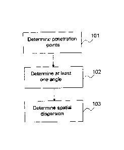
Figure 1, presents the method according to one aspect of the
invention.
Figure 2, presents the method according to a second aspect of the
invention.
Figure 3 presents two examples of projection of the penetration
points onto a circle containing the ideal points.
Figure 4 presents on the left, an example of projection of five
penetration points and, on the right, an example of five points belonging to a
set of ideally distributed points.
Figure 5 presents the distance do.
Figure 6 presents the zone around the point of interest, separated
into K contiguous annuli.
Figure 7 presents the inclination of the sight axes.
Figure 8 presents a triangular mesh.
Figure 9 presents a mode of realization of the calculation of VTEC.
CA 02835420 2013-11-29
7
Figure 10 presents another mode of realization of the calculation
of VTEC.
The method of the invention makes it possible to determine the
error in the time of propagation of a signal passing through a vertical sight
axis cutting the ionosphere at a point referred to as a point of interest.
The method such as presented in Figure 1 comprises a first step
101 of determining at least two cutting points between the ionosphere,
modelled by the surface of a polyhedron surrounding the Earth, and two
different sight axes. These sight axes link a satellite and a ground station.
Each of the two cutting or penetration points is respectively associated with
a
satellite and with a satellite terminal or with a ground station. Each
penetration point is situated at the intersection between a sight axis of the
satellite and the surface of the polyhedron. The satellite and/or the ground
station are different for different sight axes. The method thereafter
comprises
a second step 102 of determining at least one angle formed by a segment
going from the point of interest to one of the cutting points and by a segment
going from the point of interest to another of the cutting points. Finally the
method comprises a third step 103 of determining the spatial dispersion of
the said cutting points on the basis of the said angle.
It is known that the estimation of the propagation delay associated
with a point of the surface of the polyhedron known by the name IGP is
obtained by linear interpolation of the propagation delays associated with the
various penetration points (IPP). Moreover, ideally distributed points are
defined as being points of the surface of the polyhedron for which this linear
interpolation minimizes the error in estimating the propagation delay
associated with this point. The geometric position achieving the minimum
interpolation error is defined according to three types of parameters. The
first
type of parameter is the angle between the various penetration points and
the ideal points. The second type of parameter is the distance between the
various penetration points and the ideal points. The third type of parameter
is
the elevation (the elevation is defined as the angle between the sight axis
CA 02835420 2013-11-29
8
and the vertical) of the lines of sight of the various penetration points and
the
comparison with a vertical elevation.
The method such as presented in Figure 2 furthermore presents a
fourth step 201 of determining a first distance between the point of interest
and one of the cutting points and a second distance between the point of
interest and another of the cutting points. The method as presented in Figure
2 also presents a fifth step 202 of determining a first inclination of a first
sight
axis associated with one of the said cutting points and a second inclination
of
a second sight axis associated with another of the said cutting points. In
certain modes of realization it is possible to perform just the fourth step
201
or just the fifth step 202. Finally the third step 103 is adapted for
determining
the spatial dispersion on the basis of the distances and/or of the
inclinations.
In a first mode of realization, the calculation of the estimation of
the impreciseness involves the calculation of the standard deviation denoted
a which measures the spatial dispersion between the penetration points and
the ideally distributed points of the ionosphere so as to minimize the error
in
estimating the propagation time.
The ideally distributed points are so distributed on a unit circle
whose centre is the point of interest and whose radius is determined. These
points are separated by an angle of 22-r- where n is the number of points. The
penetration points (IPP) are projected onto the circle containing the ideally
distributed points. Figure 3 presents two examples of this projection. Figure
4
presents, on the left, an example of projection of five penetration points and
on the right an example of five ideally distributed points. In the case of
Figure
4, the projected points are separated by an angle denoted a, and the ideal
points are separated by an angle
In the case, the standard deviation denoted Cry is obtained as being the
average, of the difference squared between:
-the angles ai expressed in radiant of the projected points and
-the angles !! expressed in radiant of the ideally distributed points.
2 C
CIF gi2(77-
CA 02835420 2013-11-29
9
EE represents the mathematical expectation.
In this equation, c is a configuration parameter making it possible to adjust
the weight of the angular dispersion measurement in the estimation of the
propagation delay calculation error. This parameter is defined by adjustment
on the basis of real data as a function of the minimum protection volume that
the SBAS system chooses to broadcast.
In order to simplify the calculation of the average, it is possible to
disregard
the contribution of the last angle a.. Indeed the value of this angle is
contained in the other angles through the formula ¨ cr1 ¨ ¨
The formula for the standard deviation is then:
C
a =
1 ' Iran ¨1 n 1' 2
flat
The value of this standard deviation is bounded by a finite value whatever the
number of penetration points. Moreover, it equals zero when the penetration
points coincide with an ideal configuration. On the other hand, in the case
where the penetration points are in the poorest configuration (this is the
case
when all the penetration points coincide at one and the same point), the
standard deviation equals 4.
In addition to taking account of the angular dispersion, it is possible to
take
account of the dispersion in distance of the penetration points with respect
to
the point of interest.
To achieve this, it is possible to add a factor into the expression for the
standard deviation. Accordingly, the pierce points situated beyond a distance
de from the IGP point of interest are considered. Short of this distance the
IPP points are considered to be sufficiently close to allow a relevant
taxonomy. Typically the distance do, such as represented in Figure 5,
corresponds to the base of a cone of aperture 3.5 , 5 , etc., makes it
possible
to define the points which are taken into account in the calculation of the
spatial dispersion.
The parameter defining the spatial dispersion is then:
CA 02835420 2013-11-29
. reZ 04401 V idt;Adt,
du ?IL da
t=1. A
In this equation d1 is the spherical distance between the penetration point i
and the point of interest of the polyhedron, c is a configuration parameter
5 making it possible to adjust the weight of the spatial dispersion
measurement
in the estimation of the propagation delay calculation error, 7/ is the number
of
interception points considered and x(4c11) is an integer defined thus:
fx(cit, do) = 1Lfd> do,
da) = 0 if di
The standard deviation ap is then defined in the following manner:
= P--õ-E [(2-1-11 -4] + (1¨ ps
10 u
In this equation, fi is an adjustment parameter (lying between 0 and 1)
making it possible to choose to favour one or the other term of the equation.
In a second mode of calculation of the dispersion in distance of the
penetration points with respect to the point of interest, the penetration
points
are classed as a function of their distance from the point of interest. The
zone
around the point of interest is separated into K contiguous annuli such as
represented in Figure 6. In each zone the distances between the point of
interest and the penetration points are correlated. With each annulus k is
associated a weighting coefficient denoted wk, and a number of penetration
points, denoted u.k. The total number of penetration points taken into account
is then = U.01!õ . The coefficients wk are defined according to a decreasing
numerical law, which is a maximum on the disc containing the IGP point of
interest and a minimum outside the last annulus.
In this case the parameter defining the spatial dispersion is obtained by
virtue
of the equation:
S=WLtWk
The result of this equation is dimensionally equivalent to an entropy. This
equation is obtained on the basis of the discretization of the following
general
equation:
CA 02835420 2013-11-29
11
S w(x)p(x)14(x))tix with W = 4 w(x),d.
In this equation, p(x) is the probability density of having a penetration
point in
the annulus situated at a distance lying between x and x iix from the point
of interest.
It is moreover possible to take into account the inclination of the sight axis
associated with a penetration point. In this case an obliquity factor F of the
sight axis is defined by:
2.
Foy =I R, cos EIA)
14, R it I
6
In this equation EL is the elevation of the journey, 11, is the radius of the
earth
and h the height of the ionosphere. These various elements are presented in
Figure 7.
This obliquity factor makes it possible to effect the correspondence between
the journey time in the case of a vertical axis and the journey time in the
case
of an inclined axis. The principle is therefore to consider that the journeys
with a vertical axis are the journeys for which the calculation of the
duration is
the best. Indeed the calculation of the journey duration makes the
assumption of a slender ionospheric layer, this assumption therefore causes
an error in the case where the axis of the journey is inclined.
The standard deviation is therefore augmented by the following factor;
f = F(Elt)z (F(EL) ¨ 1)2 with W =EmiVF(Efai
In this equation c is a configuration parameter making it possible to adjust
the
weight of the obliquity dispersion measurement in the estimation of the
propagation delay calculation error and vF(Eit) represents the laplacian
function of the obliquity factor. This laplacian function represents the
measurement of the difference between the value of the obliquity factor F at
any penetration point and the mean value of the obliquity factor F in the
neighbourhood of a penetration point. This term therefore makes it possible
to model the variation in the obliquity factor in proximity to a point of the
polyhedron defined in respect of its elevation.
The standard deviation, denoted cp, taking into account the obliquity
criterion
is therefore defined by;
CA 02835420 2013-11-29
12
Pt
z _______________
TIN a gi) t11.5 + 112f
tin
The coefficients pt are chosen in such a way that Ept= 1.
In a second mode of realization, the calculation of the estimation
of the impreciseness involves the calculation of the standard deviation
denoted arp which measures the spatial dispersion between the penetration
points and the ideally distributed points. These points are situated at a
determined distance from the point of interest.
In this case the standard deviation is of the form:
a(
cr an
¨ ITT rr,- Litz w t _ JI with iv = Zliwt
A weighting coefficient wi has therefore been added, for each point i.
These weightings wi can be derived from an a priori function consisting of the
ionospheric spatial correlation, divided by the standard deviation of the
vertical delay associated with the penetration point. This weighting is of the
form:
zits
wt = di
In this equation d is the spherical distance between the penetration point i
and the point of interest, n is the total number of penetration points, a and
do
are configuration parameters. This equation therefore gives a high weight to
a penetration point far from the point of interest.
Another definition of the weightings is the following, this definition gives a
less significant weighting factor;
wt. = aot C49
The standard deviation ai represents the noise of the measurement seen as
an uncorrelated distribution of white noise.
In the case of these ideally distributed points, it is also possible to take
into
account the inclination of the sight axis associated with a penetration point.
Accordingly, it is possible to increment the weighting factors wi so as to
take
account of the angle of elevation of the sight axis. The weighting factors are
therefore modified in the following manner:
202
wt = Cita + bF(EOFF(E02
CA 02835420 2013-11-29
13
The value representative of the impreciseness in the propagation delay
associated with an IGP point of interest is then given by the following
formula:
GIVE = TUVE+ tool(rinrE k4)
In this equation, givar is the ionospheric delay impreciseness error (the
acronym standing for Grid Ionospheric Vertical Error), TgivE is the variance
calculated by interpolation on the basis of the TRIN model and of the
associated filtering, t(1)2 is the standard deviation of a Student's
distribution
with n degree of freedom, n being the number of pierce points IPP that are
used for the calculation of (q, UWE represents the average of the error in
calculating the ionospheric delay on each pierce point IPP, k is a coefficient
making it possible to normalize 44.
The person skilled in the art knows how to calculate the values Torz and
UNE, he can in particular refer to the document "Preliminary analysis of grid
ionospheric vertical error for GAGAN" by Niranjan Prasad published in GPS
SOLUTIONS, SPRINGER, BERLIN, DE, volume 11, number. 4, 19 June
2007, pages 281-288, which describes a mode of calculation of these
parameters.
The person skilled in the art also knows to use the document "A New Method
for Monitoring the Earth's Ionospheric Total Electron Content Using the GPS
Global Network" by A.J. Mannucci, B.D. Wilson, C.D. Edwards and published
during the ION GPS-93 conference.
This document presents the TRIN solution, the acronym standing for
TRiangular INterpolation in order to estimate the electron content of the
ionosphere and the location of the electron content with the aid of the
measurement of double frequencies gathered by a set of stations or
detection sensors. In this procedure, the ionosphere is considered to be a
thin layer, in which the whole of the ionosphere retardation of the signal is
accumulated. This thin layer makes it possible to consider that the quantity
of
retardation perceived by a signal depends only on the TEC at the site where
it pierces the thin layer of the ionosphere, this point is referred to as an
ionosphere pierce point (IPP). The typical quantity for describing the
retardation at an IPP is the delay that the vertical signal would build up at
this
CA 02835420 2013-11-29
14
point. This is related to the vertical TEC (VTEC), that is to say the integral
of
the electron density integrated ionosphere along the vertical trajectory of
the
signal in the ionosphere.
This method models the presumed slender ionospheric layer by a polytope
approximation. The model is constructed using a basic regular polyhedron
which is refined by successive subdivision (a new vertex is placed in the
middle of each edge) such as is represented in Figure 8. It is also fixed with
respect to a solar system, which is a magnetic datum, of such sort each
vertex is at a constant solar time.
The estimation of the VTEC on each vertex of the grid of the TRIN model,
such as defined previously, is done by in real time by a conventional fitting
method (Kalman type) The measurements which feed of the fitting filter are
determined on the basis of the VTEC value associated with a pierce point
IPP. These measurements are constructed mathematically as the equation of
weighted linear interpolation of each IPP (point P) with three vertices of the
triangle containing the point IPP (v1, v2, v3), see Figure 9. These
measurements are therefore determined using the relation
vrErep = wt = VTEC ,L Iva = VTEC-F ur W. VTEC. In this relation VITC7
represents the (known) VTEC of the point P, IPTEC,,. represents the VTEC at
the
point vi that needs to be fitted and vi.71 represents the weighting
coefficient at the
point IA.
The unknown values are therefore VTEC,õ associated with each vertex. The
filtering process (for example a Kalman filter) adapts the values VTIre,t
using
the relation IFTEC? = w2 = FTC +
we = tr i"ffe,a. This relation is
implemented for each point P where the VTEC is measured. The outputs of
the filters are the pair consisting of the value of the VTEC and the variance
of
the VTEC for each vertex vi of the polyhedron.
In a second step for each of the points of the grid (IGP) of the grid, the
conventional TRIN procedure makes it possible to calculate a mean value
weighted with the aid of the three estimated VTEC values close to the grid.
The linear interpolation formula is the relation
CA 02835420 2013-11-29
VTEC7= wi=VTEC.1-1. wz = VTECia+ wa = VTEC.2 where the variables V" f ileõi
are now known. This is therefore the process which is inverse to the first
step. The outputs of the filters are the pair consisting of the value of the
VTEC and the variance of the VTEC for each vertex for each IGP of the grid.
5 The value of the variance of the VTEC associated with an IGP is denoted
TGIVE_basic. This is in particular presented in Figure 10.
Thus it is possible to increment the TGIVE_basic of the basic variance of any
one of the IGP points with local information introduced by a point IPP, so as
10 to avoid the overly optimistic estimation arising from global TRIN model.
This
makes it possible to guarantee integrity of the ionospheric correction for
each
point of the grid.