Note: Descriptions are shown in the official language in which they were submitted.
CA 02836591 2013-12-13
PATENT APPLICATION IN THE U.S. PATENT AND TRADEMARK OFFICE
FOR
SYSTEMS AND METHODS FOR SAFELY LANDING AN
AIRCRAFT
by
Randall A. GREENE
FIELD OF THE DISCLOSURE
[0001] This generally relates to systems and method for safely landing an
aircraft.
More particularly, this relates to systems and methods for verifying low range
radio
altitude in an aircraft's automatic throttle system.
BACKGROUND
[0002] To safely land an aircraft, during the landing flare, the pilot
pitches the nose
of the aircraft up at an appropriate rate thereby reducing the air-speed in a
controlled
manner. At the same time, the pilot reduces the engine(s) thrust to idle.
Aircraft
automatic throttle systems (hereinafter referred to as "autothrottle") assist
the pilot by
automatically reducing the engine thrust during the landing flare.
[0003] Autothrottle automatically adjusts the throttle at predetermined
heights of the
aircraft above the ground. A low range radio altimeter (hereinafter referred
to as a
"LRRA") determines the height of the aircraft above the ground and feeds that
information to the autothrottle. Accurate LRRA readings are critical to the
safe landing of
the aircraft because an inaccurate reading may result in a premature reduction
in thrust.
To that end, the LRRA includes internal checks (error flags) to verify proper
LRRA
operation.
[0004] Undetected failures of LRRA can lead to catastrophic accidents.
Indeed,
such undetected failures have resulted in a number of safety-related instances
and at
least one major hull-loss accident. On February 25, 2009, a Boeing 737-800
airplane
crashed during an attempted landing at Amsterdam Schiphol Airport. The crash
-1-
CA 02836591 2013-12-13
investigation determined that as the airplane was approaching the airport, the
LRRA
erroneously output -8 feet. The internal LRRA controls did not detect the
error. As a
result of the erroneous LRRA reading, the autothrottle retarded the throttle
to the idle
position. This caused the autopilot to pitch up the aircraft in an attempt to
maintain glide
path, causing the aircraft to decelerate and stall. There was insufficient
height for the
pilots to recover the aircraft. Nine passengers and crew lost their lives.
[0005] Thus, autothrottle's sole reliance on LRRA internal verification has
proven to
be fatal. Accordingly, additional measures to verify LRRA accuracy would
greatly
improve the safe landing of an aircraft using autothrottle.
=
SUMMARY
[0006] This disclosure relates to a system for safely landing an aircraft.
The system
advantageously utilizes the aircraft's barometric altitude in conjunction with
a ground-
elevation database to provide a verification of the aircraft's height above
the ground. In
this way, the system can remove the autothrottle's reliance on a LRRA's
internal
verification of height and provide additional measures to ensure safe landing
of the
aircraft. Such additional measures may prevent incidents related to internally
undetected LRRA errors during landing.
[0007] In one embodiment, a system for safely landing an aircraft can
include a low
range radio altimeter, a barometric altimeter, and an autothrottle control.
The low range
radio altimeter may be used in calculating a first height of the aircraft
above ground-level
and the barometric altimeter may be used in calculating a second height of the
aircraft
above ground-level. The autothrottle control can prevent automatic thrust-
control of the
aircraft if there is an absence of correlation of the first height with the
second height. In
the event of a failure of the LRRA, this backup system may advantageously
prevent the
throttle from prematurely retarding.
[0008] In another embodiment, the system may further comprise a ground-
elevation
database. The ground-elevation database can provide an elevation of the ground
above
sea-level and can be used in calculating the second height of the aircraft.
More
specifically, the second height may be calculated by determining a difference
between
the elevation of the ground above sea-level and the elevation of the aircraft
above sea-
level provided by the barometric altimeter.
-2-
CA 02836591 2013-12-13
[0009] In a further embodiment, the ground-elevation database may comprise
at
least one of a GPS terrain database and a touch-down zone elevation database.
[0010] In yet another embodiment, the autothrottle control can determine if
the first
height and second height lack correlation by determining when the first and
second
heights deviate by a predetermined percentage.
[0011] In some embodiments, the predetermined percentage can be between 5%
and 25%.
[0012] In another embodiment, the autothrottle control can reduce automatic
thrust-
control of the aircraft through one of a control to initiate autothrottle
disable and a control
to prevent autothrottle retarding the engine(s) to idle.
[0013] In one embodiment, a method of safely landing an aircraft may
comprise
obtaining a first height of the aircraft above ground-level, obtaining a
second height of
the aircraft above ground-level, and reducing automatic thrust-control of the
aircraft if the
first height and second height are determined to lack correlation. The first
height may be
obtained using a low-range radio altimeter and the second height may be
obtained using
a barometric altimeter. In this way, the method may provide additional
measures to
ensure safe landing of the aircraft, thereby removing the autothrottle's sole
reliance on a
LRRA's internal verification of height. Such additional measures may very well
prevent
incidents related to the LRRA's failure during landing.
[0014] In a further embodiment, obtaining a second height of the aircraft
above
ground-level may further comprise accessing a ground-elevation database to
obtain an
elevation of the ground above sea-level and determining the difference between
the
ground above sea-level and an elevation of the aircraft above sea level.
[0015] In yet another embodiment, the ground-elevation database may
comprise at
least one of a GPS terrain database and a touch-down zone elevation database.
[0016] In some embodiments, determining if the first height and second
height lack
correlation may comprise determining if the first and second heights deviate
by a
predetermined percentage.
[0017] In some further embodiments, the predetermined percentage may be
between 5% and 25%.
-3-
CA 02836591 2013-12-13
[0018] In yet another embodiment, reducing automatic thrust-control of the
aircraft if
the first height and second height lack correlation comprises one of
initiating autothrottle
disable and preventing the autothrottle from retarding the engine(s) to idle.
BRIEF DESCRIPTION OF THE DRAWINGS
[0019] Figure 1 graphically depicts an aircraft landing at an airport, in
accordance
with an exemplary embodiment of the invention.
[0020] Figure 2 depicts a method of safely landing an aircraft, in
accordance with
one embodiment of the invention.
[0021] Figure 3 depicts a method of safely landing an aircraft, in
accordance with
one embodiment of the invention.
[0022] Figure 4 depicts an exemplary logic system for implementing the
systems
and method described herein.
DETAILED DESCRIPTION
[0023] In the following description of embodiments, reference is made to
the
accompanying drawings which form a part hereof, and in which it is shown by
way of
illustration specific embodiments in which the invention may be practiced. It
is to be
understood that other embodiments may be utilized and structural changes may
be
made without departing from the scope of the invention.
[0024] To remove autothrottle reliance on LRRA internal verifications, this
disclosure
provides systems and methods that utilize a barometric height to verify a
radio height.
As used herein, "barometric height" can be understood to refer to a height
above the
ground obtained by using a barometric altimeter. This may include a "QNH
barometric
altitude" or a "QFE barometric altitude." Barometric altimeters have an
adjustment
window (sometimes called a Kollsman window) to allow the pilot to adjust the
altimeter to
the current pressure reported by Air Traffic Control. A few Eastern European
countries
and some military air forces use a "QFE" adjustment. A barometric altimeter
set to QFE
will display zero feet when the aircraft is on the ground at the air field. In
the Western
-4-
CA 02836591 2013-12-13
Hemisphere and the rest of the world, the barometric setting, unless otherwise
requested, will be "QNH". A barometric altimeter set to QNH will display the
air field
elevation (above sea level) when the aircraft is on the ground at the
airfield.
[0025] As used herein, a "radio height" can be understood to refer to a
height above
the ground obtained by using a radio altimeter.
[0026] In one embodiment, a system for safely landing an aircraft includes
a low
range radio altimeter, a barometric altimeter, and an autothrottle control.
The low range
radio altimeter may be used in calculating a radio height of the aircraft
above ground-
level and the barometric altimeter may be used in calculating a barometric
height of the
aircraft above ground-level. The autothrottle control may reduce automatic
thrust-control
of the aircraft if the radio height is determined to not correlate with the
barometric height.
[0027] Figure 1 graphically depicts an aircraft 110 landing at an airport
116, in
accordance with an exemplary embodiment of the invention. Aircraft 110 obtains
a
height 120 above the ground 112 using a LRRA (not shown), an elevation 140 of
the
aircraft 110 above sea level 114 (or barometric altitude) from a barometric
altimeter (not
shown), and an elevation 130 of the ground 112 above sea level 114 from a
ground
elevation database (not shown). The radio height may be read directly from the
height
120 above the ground 112 and the barometric height may be calculated by
determining
the difference between the elevation 130 of the ground 112 above sea-level 114
and the
elevation 140 of the aircraft 110 above sea-level 114. In the event of a
failure of an
internal LRRA verification, the barometric height can be used to detect the
error and,
thus, may advantageously prevent the throttle from prematurely retarding due
to the
error.
[0028] Although Figure 1 depicts the radio height (equivalent to LRRA
reading 120)
and the barometric height (elevation 140 ¨ elevation 130) as equal, in some
embodiments the radio height and barometric height are not equal. For example,
the
radio height and barometric height may not be equal due to an LRRA error. In
such a
scenario, although the LRRA may be configured to provide the height of the
aircraft
above the ground, the radio height provided by the LRRA may not correspond to
the
height of the aircraft above the ground.
[0029] In some embodiments, the barometric altitude is provided by the
aircraft's air
data computer. The ground-elevation database may comprise one or more of a GPS
-5-
CA 02836591 2013-12-13
terrain database and a touch-down zone elevation database. In other
embodiments, the
ground-elevation database may include any database capable of providing an
aircraft's
real-time elevation above the ground.
[0030] If the barometric height and the radio height are determined to lack
correlation, autothrottle may be prevented from reducing the thrust or it can
be
disconnected. The heights may be determined to lack correlation when they are
not
precisely the same. In other embodiments, the heights are determined to lack
correlation when they deviate by a predetermined percentage. Such percentages
may
be tailored to the parameters of a specific application, but could include any
percentage
between 5% and 25%.
[0031] The autothrottle control may reduce automatic thrust-control of the
aircraft by
one or more methods of a control. One would be to initiate autothrottle
disable and a
control to prevent autothrottle from retarding. For example, the radio and
barometric
heights may lack correlation before autothrottle is enabled and, thus, the
system
prevents the autothroftle's enabling of the retard function. In other cases,
autothrottle
may have already been enabled with a valid LRRA, which later became invalid
and,
thus, autothrottle is later disabled. As an example of this latter scenario,
suppose
autothrottle is initiated at 200 ft. If the radio and barometric heights
correlate at 200 ft.
then autothrottle retardation of the engine(s) to idle will not be prevented.
On short final
approach to landing, at an altitude of 100 to 50 feet above the ground, the
automatic
throttle system will start to bring the throttles back to idle (the exact
height will be set in
the design but will vary with the size of the aircraft, for example, a 747
would probably be
at 100 ft.+ and a business jet at 50 ft.). At this stage, the radio and
barometric heights
may again be compared and, if they lack correlation, autothrottle is then
disabled and
the crew alerted.
[0032] In some embodiments, the pilots are notified when the barometric and
radio
heights lack correlation. The pilots may then manually land the plane, or take
measures
to investigate the source of the discrepancy, correct the source of the
discrepancy, and
fully enable autothrottle. If the pilots are unable to see the runaway, and
thereby are
unable to manually land the aircraft safely, the pilots may need to execute a
missed
approach / go-around.
[0033] Figure 2 depicts a Method 200 of safely landing an aircraft, in
accordance
with one embodiment of the invention. Method 200 includes obtaining 202 a
radio height
-6-
CA 02836591 2013-12-13
(HD) of the aircraft above ground-level, obtaining 204 a barometric height
(HBAR) of the
aircraft above ground-level, determining 206 if the radio height and
barometric height
lack correlation, and reducing 208 automatic thrust-control of the aircraft if
the radio
height and the barometric height lack correlation. The radio height may be
obtained
using a low-range radio altimeter and the barometric height may be obtained
using a
barometric altimeter. In this way, the method provides additional measures to
ensure
safe landing of the aircraft, thereby removing the autothrottle's sole
reliance on a LRRA's
internal verification of height. Such additional measures may very well
prevent incidents
related to the LRRA's failure during landing.
[0034] Obtaining the elevation of the aircraft above ground level may
include
accessing a ground elevation database to obtain an elevation of the ground
above sea
level and determining the difference between the elevation of the ground above
sealevel
and an elevation of the aircraft above sea level. The ground elevation
database may
include one or more of a GPS terrain database and a touch-down zone elevation
database. In other embodiments, the ground-elevation database may include any
database capable of providing an aircraft's real-time elevation above the
ground
[0035] Determining if the radio height and the barometric height lack
correlation may
include determining if the radio height is precisely the same as the
barometric height.
The determination may allow for some variance, such as a deviation by a
predetermined
percentage. Such percentages may include a percentage between 5% and 25%.
[0036] Preventing automatic thrust control of the aircraft if the radio
height and
barometric height lack correlation may include initiating autothrottle disable
or preventing
autothrottle retarding the engine(s) to idle.
[0037] Figure 3 depicts a Method 300 of safely landing an aircraft, in
accordance
with one embodiment of the invention. Method 300 is similar to Method 200
described
above with respect to Figure 2, and includes the additional steps of obtaining
(306) a
height of the terrain under the aircraft (HTERR) and subtracting (308) the
height of the the
terrain under the aircraft from the barometric altitude to calculate a height
above the
ground (Hc). The radio height is then compared to the height calculated above
the
ground.
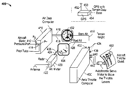
[0038] Figure 4 depicts an exemplary logic System 400 for implementing the
systems and methods described herein. System 400 includes an barometric
altitude
-7-
CA 02836591 2013-12-13
gauge 402, a radio altitude gauge 404, an air data computer 410, a radar
altimeter 420,
an autothrottle computer 430, a GPS 450, and an aircraft throttle quadrant
460.
[00391 Air data computer 410 includes inputs 412 and 414 and outputs 416
and 418.
Input 412 provides an aircraft static pressure port and input 414 is a pilot
tube. From
inputs 412 and 414, the air data computer determines the barometric altitude
and
provides outputs 416 and 418 with the barometric altitude information. Output
416 is fed
to barometric altitude gauge 402 and output 418 is fed to the autothrottle
computer.
[0040] Radar altimeter 420 includes input 422 and outputs 424 and 426.
Input 422
is received from an antenna. From input 422, the radar altimeter determines
the radio
altitude and provides outputs 424 and 426 with the radio altitude information.
Output
424 is fed to radar altitude gauge 404 and output 426 is fed to the
autothrottle computer.
From inputs 412 and 414, the air data computer determines the airspeed (not
shown).
[0041] GPS 450 includes input 452, output 454, and a terrain database.
Input 452 is
received from an antenna. From input 452, GPS 450 determines a height of the
terrain
above sea-level and provides output 454 with that information. Output 454 is
fed to the
autothrottle computer 430.
[0042] Autothrottle computer 430 includes inputs 432, 434, and 436 and
outputs 438
and 440. Inputs 432, 434, and 436 correspond to the radio altitude, barometric
altitude,
and height of the terrain above sea level, respectively. From inputs 432, 434,
and 436,
autothrottle computer 430 determines if the radio altitude is accurate, as
described
above. Depending on the results of this determination, autothrottle computer
430
controls the aircraft throttle quadrant 460 using inputs 440 and 442.
[0043] It is understood that System 400 is offered by way of an example,
and other
systems could be used to implement the systems and methods described herein.
Such
systems may include computer based systems.
[0044] In some embodiments, the logic to initiate the throttle to retard
the throttles in
preparation for the flare may be a combination of: 1) a valid LLRA, AND 2) an
LLRA
altitude at or below the trigger altitude, AND 3) a valid air data computer,
AND 4) a valid
terrain or navigation database, AND 5) a computed height above ground equal to
or less
than the trigger altitude.
[0045] One skilled in the relevant art will recognize that many possible
modifications
and combinations of the disclosed embodiments can be used, while still
employing the
-8-
CA 02836591 2013-12-13
same basic underlying mechanisms and methodologies. The foregoing description,
for
purposes of explanation, has been written with references to specific
embodiments.
However, the illustrative discussions above are not intended to be exhaustive
or to limit
the disclosure to the precise forms disclosed. Many modifications and
variations can be
possible in view of the above teachings. The embodiments were chosen and
described
to explain the principles of the disclosure and their practical applications,
and to enable
others skilled in the art to best utilize the disclosure and various
embodiments with
various modifications as suited to the particular use contemplated.
[0046]
Further, while this specification contains many specifics, these should not be
construed as limitations on the scope of what is being claimed or of what may
be
claimed, but rather as descriptions of features specific to particular
embodiments.
Certain features that are described in this specification in the context of
separate
embodiments can also be implemented in combination in a single embodiment.
Conversely, various features that are described in the context of a single
embodiment
can also be implemented in multiple embodiments separately or in any suitable
subcombination. Moreover, although features may be described above as acting
in
certain combinations and even initially claimed as such, one or more features
from a
claimed combination can in some cases be excised from the combination, and the
claimed combination may be directed to a subcombination or variation of a
subcombination.
-9-