Note: Descriptions are shown in the official language in which they were submitted.
CA 02836702 2013-11-19
WO 2012/166111 PCT/US2011/038538
AZIMUTHAL BRITTLENESS LOGGING SYSTEMS AND METHODS
BACKGROUND
It is useful to know certain characteristics of a borehole for drilling
operations. In order
to gather information about the borehole, drillers often use a wireline or
logging while drilling
(LWD) tool that can retrieve data and produce logs or even images representing
the
characteristics of the formations penetrated by the borehole. An example of
one such tool is a
sonic logging tool, which operates by generating sonic pulses and measuring
the time it takes for
such pulses to propagate along the borehole. With such measurements, drillers
are able to
measure a variety of geological characteristics including formation density
and porosity.
One of the properties that drillers may find important is some measure of
formation
brittleness. Moderately brittle formations may be expected to be easily
fractured and hence more
permeable to fluid flows. Ideally, the driller would like to position the
borehole in a region where
such permeability provides access to a reservoir of hydrocarbons. Highly
brittle formations, on
the other hand, may be expected to be unstable and prone to borehole cave-ins
and collapse, a
situation which could cause economic and environmental losses and even
necessitate
abandonment of the well. There do not appear to be any logging systems and
methods available
for providing drillers with suitable azimuthal formation brittleness
measurements during the
drilling process.
BRIEF DESCRIPTION OF THE DRAWINGS
A better understanding of the various disclosed embodiments can be obtained
when the
following detailed description is considered in conjunction with the following
drawings, in
which:
1
CA 02836702 2013-11-19
WO 2012/166111 PCT/US2011/038538
Fig. 1 shows an illustrative drilling environment where geosteering is
employed;
Fig. 2 shows an illustrative wireline drilling environment;
Fig. 3 is an illustrative sonic logging tool;
Fig. 4 shows an illustrative cross plot of Young's Modulus and Poisson's Ratio
for a borehole;
Fig. 5 is an illustrative borehole image for azimuthal brittleness index; and
Fig. 6 is an illustrative flow diagram for computing and displaying azimuthal
brittleness.
DETAILED DESCRIPTION
The issues identified in the background are at least in part addressed by the
disclosed
methods and systems for gathering, deriving, and displaying the azimuthal
brittleness index of a
borehole. At least some embodiments include various methods for calculating
and displaying
borehole measurements in real-time for geosteering and drilling operations. At
least one
disclosed method embodiment for calculating and displaying azimuthal
brittleness includes
taking measurements of compressional and shear wave velocities as a function
of position and
orientation from inside the borehole. These velocity measurements are taken by
a sonic tool.
Azimuthal brittleness is then derived based at least in part on the
compressional and shear wave
velocities, and is displayed to the driller who can then adjust the drilling
direction based on the
azimuthal brittleness information. A logging system to implement the above
stated methods
includes an azimuthal sonic tool and a processor that retrieves measurements
from the sonic tool
to generate a brittleness image log and, in a geosteering application, to
optionally guide the
drillstring based at least in part on the brittleness image log.
To further assist the reader's understanding of the disclosed systems and
methods, we
describe an environment suitable for their use and operation. An illustrative
geosteering
environment is shown in Fig. 1. A drilling platform 2 supports a derrick 4
having a traveling
2
CA 02836702 2013-11-19
WO 2012/166111 PCT/US2011/038538
block 6 for raising and lowering a drill string 8. A top drive 10 supports and
rotates the drill
string 8 as it is lowered through the wellhead 12. A drill bit 14 is driven by
a downhole motor
and/or rotation of the drill string 8. As bit 14 rotates, it creates a
borehole 16 that passes through
various formations. The drill bit 14 is just one piece of a bottom-hole
assembly that typically
includes one or more drill collars (thick-walled steel pipe) to provide weight
and rigidity to aid
the drilling process. Some of these drill collars may include logging
instruments to gather
measurements of various drilling parameters such as position, orientation,
weight-on-bit,
borehole diameter, etc. The tool orientation may be specified in terms of a
tool face angle
(rotational orientation), an inclination angle (the slope), and compass
direction, each of which
can be derived from measurements by magnetometers, inclinometers, and/or
accelerometers,
though other sensor types such as gyroscopes may alternatively be used. The
system further
includes a tool 26 to gather measurements of formation properties from which
formation
boundaries can be identified as discussed further below. Using these
measurements in
combination with the tool orientation measurements, the driller can steer the
drill bit 14 along a
desired path 18 using any one of various suitable directional drilling
systems, including steering
vanes, a "bent sub", and a rotary steerable system. A pump 20 circulates
drilling fluid through a
feed pipe 22 to top drive 10, downhole through the interior of drill string 8,
through orifices in
drill bit 14, back to the surface via the annulus around drill string 8, and
into a retention pit 24.
The drilling fluid transports cuttings from the borehole into the pit 24 and
aids in maintaining the
borehole integrity. Moreover, a telemetry sub 28 coupled to the downhole tools
26 can transmit
telemetry data to the surface via mud pulse telemetry. A transmitter in the
telemetry sub 28
modulates a resistance to drilling fluid flow to generate pressure pulses that
propagate along the
fluid stream at the speed of sound to the surface. One or more pressure
transducers 30, 32
3
CA 02836702 2013-11-19
WO 2012/166111 PCT/US2011/038538
convert the pressure signal into electrical signal(s) for a signal digitizer
34. Note that other forms
of telemetry exist and may be used to communicate signals from downhole to the
digitizer. Such
telemetry may employ acoustic telemetry, electromagnetic telemetry, or
telemetry via wired
drillpipe.
The digitizer 34 supplies a digital form of the pressure signals via a
communications link
36 to a computer 38 or some other form of a data processing device. Computer
38 operates in
accordance with software (which may be stored on information storage media 40)
and user input
via an input device 42 to process and decode the received signals. The
resulting telemetry data
may be further analyzed and processed by computer 38 to generate a display of
useful
information on a computer monitor 44 or some other form of a display device.
For example, a
driller could employ this system to obtain and monitor drilling parameters,
formation properties
including an azimuthal brittleness log, and the path of the borehole relative
to detected formation
boundaries 46 and 48.
Fig. 2 shows an illustrative wireline logging environment. At various times
during the
drilling process, the drill string 8 is removed from the borehole to allow the
use of a wireline
logging tool 134. The wireline logging tool is a sensing instrument sonde
suspended by a cable
142 having conductors for transporting power to the tool and telemetry from
the tool to the
surface. The wireline logging tool 134 may have arms 136 that center the tool
within the
borehole or, if desired, press the tool against the borehole wall. The
borehole penetrates various
formations 121. A logging facility 144 collects measurements from the logging
tool 134, and
includes computing facilities for processing and storing the measurements
gathered by the
logging tool.
4
PCT/US11/38538 26-03-2013
PCT/US2011/038538 01.11.2013
CA 02836702 2013-11-19
1391-835.00 / 2011-IP-044936 PCT Replacement Sheet
Fig. 3 shows an illustrative sonic logging tool for use in a logging while
drilling
environment. Similar tool configurations are available for use in a wireline
logging environment.
The logging tool shown has 4 azimuthal transmitters 302 that can be operated
as a monopole,
dipole, crossed-dipole, or quadrupole source. The logging tool also has
acoustic callipers 304,
and azimuthally-sensitive receiver arrays 306. The acoustic callipers 304 are
aligned with the
receiver arrays 306 for accurate measurement of hole size, shape, and tool
position. As the
logging tool rotates within the borehole, it gathers information by measuring
compressional and
shear wave velocities. Each of the transmitters 302 are capable of firing a
positive or negative
wave and operating cooperatively to create sound waves that propagate in
monopole, dipole,
quadrupole, and crossed-dipole modes. The illustrated tool has four
azimuthally spaced arrays of
receivers 306, with 6 receivers in each array. Each array has its closest
receiver located 5 ft from
the transmitter, with 6 inches between each successive receiver. Each receiver
is sensitive across
a broad range of frequencies and is isolated from the collar in a manner to
eliminate bit noise and
mud circulation noise. A processor collects measurements from each receiver's
response to the
transmitter firings to measure the propagation speeds of the various wave
modes and to extract
azimuthally-sensitive measurements of the compressional and shear wave
propagation velocities.
When analyzing sonic data, accurate knowledge of the borehole size and shape
as well as
the position of the tool in the borehole can be used to increase measurement
accuracy and
sharpen the resolution of the azimuthal image. In the wireline environment,
multi-arm
mechanical callipers are usually run in conjunction with the sonic tool to
acquire this
information, whereas the illustrated tool employs four ultrasonic callipers
(one aligned with each
receiver array). Every time sonic data is collected, the four ultrasonic
callipers make a near-
simultaneous measurement of distances to the borehole wall. The four calliper
measurements can
Page 5 of 15
AMENDED SHEET -1PEA/US
CA 02836702 2013-11-19
WO 2012/166111 PCT/US2011/038538
be used to determine hole size and the position of the tool in the borehole.
The tool can be
programmed to acquire image data in 1-, 2-, 4-, 8-, or 16- sector resolution,
or even higher if
desired. In practice, data is often acquired with 16 sector azimuthal
resolution.
For each sector around the borehole, at a given depth, measurements of the
compressional and shear wave velocities are taken. From these raw
measurements, Young's
Modulus and Poisson's Ratio can be derived, given a reasonable estimate of
density either from
another logging tool or offset well log. Alternatively, a density estimate can
be derived from the
sonic logging tool measurements in accordance with the methods disclosed in co-
pending U.S.
App. 13/003,609, "Systems and Methods for Acoustically Measuring Bulk
Density", filed Jan
11, 2011, by M. Oraby. Poisson's Ratio can be expressed in terms of
compressional wave
velocity (Vp) and shear wave velocity (Vs) as follows:
v = 0.5(Vp /Ks ¨1
= (I)
i/
(p ¨ T/s)2 -1
The Young's modulus can then be calculated based on density ( p) , Poisson's
Ratio (v), and shear
wave velocity ( Vs):
E = pV (1 + . (2)
Due to the azimuthal dependence of the compressional and shear wave velocity
measurements
(and possibly the density measurements as well), the values of Poisson's Ratio
and Young's
modulus can be derived as a function of borehole position and azimuth to
provide image logs of
these values. These image logs can then be combined in accordance with the
teachings of
Rickman, et. al. "A Practical Use of Shale Petrophysics for Stimulation Design
Optimization: All
Shale Plays Are Not Clones of the Barnett Shale" [SPE 115258] (2008) to derive
a brittleness
6
CA 02836702 2013-11-19
WO 2012/166111 PCT/US2011/038538
index for each sector. Various brittleness measures can be employed, including
a brittleness
index expressible as
BI = (ciE + c2 v) / 2,
(3)
where ci and c2 are coefficients that equalize the significance of each factor
as a brittleness
indicator.
Fig. 4 shows an illustrative cross plot of Young's Modulus and Poisson's Ratio
as
determined from the sonic logs of a test well. The less brittle area 402 and
the more brittle area
404 of the borehole are both shown in this Figure. The Young's Modulus and
Poisson's Ratio
components are combined to reflect the rocks ability to fail under stress and
maintain a fracture
once the rock fractures. Ductile shale (which would occur in area 402) is not
a good formation
for accessing a reservoir because the formation will tend to heal any natural
or hydraulic
fractures. Ductile shale however, makes a good seal, trapping the hydrocarbons
from migrating
out of the more brittle shale below. Brittle shale (which would occur near
area 404) is more
likely to be naturally fractured and will also be more likely to respond well
to hydraulic
fracturing treatments. Thus, it is desirable to quantify the brittleness
factor in a way that
combines both rock mechanical properties in shale. Fig. 4 is a graphical
representation of this
concept. In terms of Poisson's Ratio, the lower the value, the more brittle
the rock, and as values
of Young's Modulus increase, the more brittle the rock will be. Because the
units of Poisson 's
Ratio and Young's Modulus are very different, the brittleness caused by each
component is
unitized, and then averaged to yield the brittleness coefficient as a
percentage.
Fig. 5 shows an illustrative image log representation of azimuthal brittleness
index that
can be calculated and displayed during drilling operations. An image log of
brittleness index can
be useful during posteering. This technology takes advantage of the fact that
LWD tools rotate
7
CA 02836702 2013-11-19
WO 2012/166111 PCT/US2011/038538
while acquiring data to create sonic velocity images around the borehole.
Along the horizontal
axis, the log shows the dependence of the brittleness index on the tool's
depth or position in the
borehole. Along the vertical axis, the log shows the dependence of the
brittleness index on the
azimuth or rotational angle of the tool. Usually, the upper and lower edges of
the log represent
the high side of the borehole, while the middle represents the low side. It
can be observed that
the log reveals changes to the brittleness index of the formations penetrated
by the borehole,
enabling the driller to identify desirable formations and steer the borehole
to maximize exposure
to such formations.
For example, assume that the driller regards the formation represented by area
502 as
having a desirable brittleness index. As the drilling assembly encounters an
adjacent formation
having a less desirable brittleness index (as represented by area 504), the
driller takes corrective
action and steers the borehole back to the desirable formation (represented
again by area 506).
Perhaps due to an overcorrection, the borehole passes entirely through the
desirable formation
and further steering corrections are required. The information revealed by the
brittleness image
log can assist the driller in geosteering the borehole into a economically
desirable formation.
These images can also be used as traditional wireline crossed-dipole data are
used (for stress
analysis, fracture characterization, and 3-dimensional rock mechanics) as well
as to provide
additional services such as geosteering.
In addition to formation permeability, borehole stability issues are also a
concern during
drilling operations. For example, certain areas of the borehole may be too
brittle for drilling. If
an extremely brittle area is drilled, then the entire borehole is likely to
collapse creating a
catastrophic loss in materials and resources. On the other hand, a brittle
area of the borehole can
also represent a more permeable area of the borehole. More gas is likely to
flow through more
8
CA 02836702 2013-11-19
WO 2012/166111 PCT/US2011/038538
permeable areas of the borehole. Thus, a trade-off exists, and it is desirable
for the driller to
quickly be aware of the brittle index of a borehole while conducting drilling
operations.
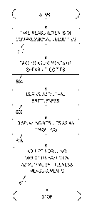
Fig. 6 shows an illustrative method for calculating and displaying azimuthal
brittleness.
In blocks 602 and 604, a sonic logging tool acquires measurements for both
compressional and
shear velocities in the borehole. In block 606 a surface processing system
calculates azimuthal
brittleness and associates it with the position and orientation of the sonic
logging tool to form an
azimuthal brittleness image log. In block 608, the surface processing system
displays the log to
an engineer, e.g., for use in analyzing borehole stability and determining a
suitable hydraulic
fracturing procedure. Optionally, the log may be acquired during the drilling
process and
displayed in real time to the driller. In block 610, the driller adjusts the
drilling direction based
on the azimuthal brittleness logs.
Different embodiments for methods and systems to detemine azimuthal
brittleness and
optionally employ it as a guide during drilling operations are presented. A
method embodiment
for calculating and displaying azimuthal brittleness includes taking
measurements of
compressional and shear wave velocities as a function of position and
orientation from inside the
borehole. Azimuthal brittleness is then derived at least in part from these
velocities.
Another method embodiment for performing a geosteering operation includes
determining azimuthal brittleness of a borehole, and automatically adjusting a
drilling direction
based at least in part on the determination of azimuthal brittleness. A
logging system to
implement the above stated methods includes an azimuthal sonic tool and a
processor that
retrieves measurements from the sonic tool. The system can also include a
geosteering assembly,
and be used during both wireline and LWD operations.
9
CA 02836702 2013-11-19
WO 2012/166111 PCT/US2011/038538
It is contemplated that the azimuthal brittleness logs could be used to direct
perforation
guns and stimulation jets for increased penetration. These and other
variations and modifications
will become apparent to those skilled in the art once the above disclosure is
fully appreciated. It
is intended that the following claims be interpreted to embrace all such
variations and
modifications.