Some of the information on this Web page has been provided by external sources. The Government of Canada is not responsible for the accuracy, reliability or currency of the information supplied by external sources. Users wishing to rely upon this information should consult directly with the source of the information. Content provided by external sources is not subject to official languages, privacy and accessibility requirements.
Any discrepancies in the text and image of the Claims and Abstract are due to differing posting times. Text of the Claims and Abstract are posted:
| (12) Patent: | (11) CA 2837684 |
|---|---|
| (54) English Title: | VEHICLE LOCALIZATION SYSTEM |
| (54) French Title: | SYSTEME DE LOCALISATION DE VEHICULE |
| Status: | Granted and Issued |
| (51) International Patent Classification (IPC): |
|
|---|---|
| (72) Inventors : |
|
| (73) Owners : |
|
| (71) Applicants : |
|
| (74) Agent: | MARKS & CLERK |
| (74) Associate agent: | |
| (45) Issued: | 2015-12-01 |
| (86) PCT Filing Date: | 2012-06-19 |
| (87) Open to Public Inspection: | 2012-12-27 |
| Examination requested: | 2014-03-31 |
| Availability of licence: | N/A |
| Dedicated to the Public: | N/A |
| (25) Language of filing: | English |
| Patent Cooperation Treaty (PCT): | Yes |
|---|---|
| (86) PCT Filing Number: | PCT/CA2012/000600 |
| (87) International Publication Number: | WO 2012174645 |
| (85) National Entry: | 2013-11-28 |
| (30) Application Priority Data: | ||||||
|---|---|---|---|---|---|---|
|
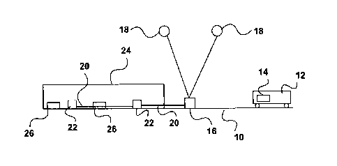
A localization system for a vehicle running on a guideway including portions obscured from satellite view has a number of GNSS receivers placed at strategic locations along the guideway in view of navigation satellites. GNSS transmitters retransmit received GNSS signals along an obscured portion of the guideway. Coded targets are placed at known locations along the guideway. A GNSS receiver on the vehicle picks up GNSS signals directly from the navigation satellites or retransmitted from the GNSS transmitters when on an obscured portion of the guideway. A proximity sensor on the vehicle detects the coded targets. An on-board computer synchronizes the location obtained from the GNSS signals with the location obtained from the proximity sensor. The vehicle is thus able to determine its position even in an obscured portion, such as a tunnel.
La présente invention concerne un système de localisation pour un véhicule se déplaçant sur une voie de guidage comprenant des parties masquées à la vue des satellites. Ledit système possède un certain nombre de récepteurs GNSS placés en des endroits stratégiques le long de la voie de guidage, visibles par les satellites de navigation. Les émetteurs GNSS réémettent les signaux GNSS reçus le long d'une partie masquée de la voie de guidage. Des cibles codées sont situées en des emplacements connus le long de la voie de guidage. Un récepteur GNSS sur le véhicule récupère les signaux GNSS directement depuis les satellites de navigation ou réémis par les émetteurs GNSS lorsqu'ils se trouvent sur une partie masquée de la voie de guidage. Un capteur de proximité sur le véhicule détecte les cibles codées. Un ordinateur embarqué synchronise l'emplacement obtenu à partir des signaux GNSS avec l'emplacement obtenu à partir du capteur de proximité. Le véhicule est ainsi capable de déterminer sa position même lorsqu'il se trouve dans une partie masquée telle qu'un tunnel.
Note: Claims are shown in the official language in which they were submitted.
Note: Descriptions are shown in the official language in which they were submitted.
2024-08-01:As part of the Next Generation Patents (NGP) transition, the Canadian Patents Database (CPD) now contains a more detailed Event History, which replicates the Event Log of our new back-office solution.
Please note that "Inactive:" events refers to events no longer in use in our new back-office solution.
For a clearer understanding of the status of the application/patent presented on this page, the site Disclaimer , as well as the definitions for Patent , Event History , Maintenance Fee and Payment History should be consulted.
| Description | Date |
|---|---|
| Inactive: Recording certificate (Transfer) | 2023-09-20 |
| Inactive: Multiple transfers | 2023-08-31 |
| Common Representative Appointed | 2019-10-30 |
| Common Representative Appointed | 2019-10-30 |
| Grant by Issuance | 2015-12-01 |
| Inactive: Cover page published | 2015-11-30 |
| Pre-grant | 2015-09-16 |
| Inactive: Final fee received | 2015-09-16 |
| Notice of Allowance is Issued | 2015-08-31 |
| Letter Sent | 2015-08-31 |
| Notice of Allowance is Issued | 2015-08-31 |
| Inactive: Q2 passed | 2015-06-30 |
| Inactive: Approved for allowance (AFA) | 2015-06-30 |
| Amendment Received - Voluntary Amendment | 2015-02-10 |
| Letter Sent | 2014-04-08 |
| Request for Examination Requirements Determined Compliant | 2014-03-31 |
| All Requirements for Examination Determined Compliant | 2014-03-31 |
| Request for Examination Received | 2014-03-31 |
| Inactive: Cover page published | 2014-01-17 |
| Inactive: Notice - National entry - No RFE | 2014-01-09 |
| Inactive: First IPC assigned | 2014-01-08 |
| Inactive: IPC assigned | 2014-01-08 |
| Application Received - PCT | 2014-01-08 |
| National Entry Requirements Determined Compliant | 2013-11-28 |
| Application Published (Open to Public Inspection) | 2012-12-27 |
There is no abandonment history.
The last payment was received on 2015-06-11
Note : If the full payment has not been received on or before the date indicated, a further fee may be required which may be one of the following
Please refer to the CIPO Patent Fees web page to see all current fee amounts.
| Fee Type | Anniversary Year | Due Date | Paid Date |
|---|---|---|---|
| Basic national fee - standard | 2013-11-28 | ||
| MF (application, 2nd anniv.) - standard | 02 | 2014-06-19 | 2013-11-28 |
| Request for exam. (CIPO ISR) – standard | 2014-03-31 | ||
| MF (application, 3rd anniv.) - standard | 03 | 2015-06-19 | 2015-06-11 |
| Final fee - standard | 2015-09-16 | ||
| MF (patent, 4th anniv.) - standard | 2016-06-20 | 2016-06-14 | |
| MF (patent, 5th anniv.) - standard | 2017-06-19 | 2017-06-12 | |
| MF (patent, 6th anniv.) - standard | 2018-06-19 | 2018-04-30 | |
| MF (patent, 7th anniv.) - standard | 2019-06-19 | 2019-06-10 | |
| MF (patent, 8th anniv.) - standard | 2020-06-19 | 2020-03-04 | |
| MF (patent, 9th anniv.) - standard | 2021-06-21 | 2021-04-05 | |
| MF (patent, 10th anniv.) - standard | 2022-06-20 | 2022-04-07 | |
| MF (patent, 11th anniv.) - standard | 2023-06-19 | 2023-03-30 | |
| Registration of a document | 2023-08-31 | 2023-08-31 | |
| MF (patent, 12th anniv.) - standard | 2024-06-19 | 2024-03-07 |
Note: Records showing the ownership history in alphabetical order.
| Current Owners on Record |
|---|
| GROUND TRANSPORTATION SYSTEMS CANADA INC. |
| Past Owners on Record |
|---|
| ABE KANNER |

