Note: Descriptions are shown in the official language in which they were submitted.
CA 02837905 2013-12-02
WO 2012/172181 PCT/F12012/050606
1
Method and arrangement for preparing a charging plan
Background of the invention
[0001] The invention relates to a method for preparing a charging
plan for excavation of a rock cavern, the method comprising determining in ad-
vance at least drill hole locations in a pre-determined coordinate system for
a
round to be drilled into the rock cavern and creating a charging plan for the
holes in the round by means of a computer-aided design program for blasting
the round.
lo [0002]
The invention further relates to an arrangement for designing
a charging plan for excavating a rock cavern with a rock drilling apparatus
comprising one or more drilling booms having a rock drilling unit attached to
it
and a control unit for controlling the drilling comprising a computer, whereby
at
least locations of drill holes in a predetermined coordinate system has been
defined in advance for a round to be drilled which arrangement comprises a
computer with the computer assisted design program for designing the charg-
ing plan.
[0003] Tunnels, underground storage silos and other rock caverns
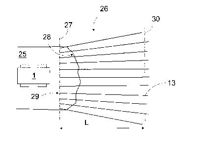
are excavated in rounds. In a tunnel or other part of a rock cavern, drill
holes
are drilled, and then charged and blasted after the drilling. One blast
detaches
from the rock an amount of rock material that equals that of one round. For ex-
cavating a rock cavern, a plan is made in advance and information about the
rock type, for example, is determined. In general, the orderer of the rock cav-
ern also sets various quality requirements for the cavern to be excavated.
[0004] When tunnel drilling is performed by a rock drilling apparatus
provided with instrumentation, there is generally designed, as office work, a
drilling plan for drilling a round and a charging plan for blasting the round.
The
drilling plan and the charging plan are supplied to the rock drilling
apparatus for
being used by means of its control computer. The drilling plan serves as a con-
trolled instruction for drilling drill holes in the rock in such a manner that
a de-
sired round can be formed.
[0005] The successfulness of drilling and charging is measured, in-
ter alia, by pull-out per round, which refers to the ratio of advance of the
tunnel
after a blast to a designed length in the drilling plan. Improvement of pull-
out
from 88 to 95 percent, for instance, means significant cost savings in an exca-
CA 02837905 2013-12-02
WO 2012/172181 PCT/F12012/050606
2
vation project. In practice, defining an optimal pull-out is aimed at by
changing
the drilling plan or the charging plan. Examples of parameters applied in
changing the charging plan include distances between the drill holes, specific
charge, charging degree, blast cut in different areas of the plan.
[0006] For designing a charging plan there are developed design
programs that assist the designer in composing the charging plan. Designing a
charging plan is thus an interactive action between the designer and the de-
sign program.
[0007] Production of drilling plans and continuous design, as well as
review of plans during tunnel work, have been developed in various ways in
view of blasting techniques, for instance. This is presented in publication WO
2008/078001, for instance.
[0008] In practice, in round blasting it has been found that even
though the hole locations and the size and amount of blasting charges are di-
mensioned as well as possible on the basis of the known facts , the outcome of
the blast does not, however, meet the planned design. Typically, when de-
tached material is removed after the blast, it may be found that the remaining
rock surface deviates significantly from the theoretical surface that should
have
been created after the blast. This may result from a plurality of different
factors,
such as fracturing properties or hardness of rock, or some other factor that
cannot have been known in advance with a sufficient accuracy. As a conse-
quence, however, the efficiency of excavation deteriorates and this, in turn,
causes quite significant additional costs.
Brief description of the invention
[0009] The object of the present invention is to provide a method
and an arrangement for producing drilling plans in which conditions are taken
into account better than before, and consequently, a tunnel may be excavated
more efficiently and more accurately than previously. The method of the inven-
tion is characterised by determining, in connection with hole drilling, the
loca-
tion of an end for at least some of the holes; storing the determined
locations
of hole ends in a memory; determining pull-out of a round on the basis of the
locations of the determined hole ends and the topography of rock remaining af-
ter a round blast and designing or modifying the charging plan of a subsequent
round on the basis of the thus determined pull-out.
CA 02837905 2013-12-02
WO 2012/172181 PCT/F12012/050606
3
[0010] The arrangement of the invention is characterised in that the
arrangement comprises means for locating the location of the actual ends for
at least some of the holes, means for storing the determined locations of the
hole ends in a memory and means for determining the topography of the rock
remaining after the round blast and whereby the pull-out of the blasted round
can be defined on the basis of the defined end locations of the drill holes
and
the topography of the rock remaining after the blasted round and the charging
plan may be designed or modified on the basis of the thus defined pull-out.
[0011] The idea of the invention is that in designing a charging plan
for one or more subsequent rounds, the differences between the locations of
drill hole ends of a last-blasted round and the locations of starting points
of
new holes to be drilled are taken into account. Further, the idea is that the
charging plan is modified on the basis of these differences.
[0012] An advantage of the invention is that by taking into account
the deviations from the plan appearing in the last-blasted round after the
blast-
ing, a more appropriate and more efficient charging plan for subsequent
rounds is achieved, which will subsequently increase pull-out per round and
thus improves the efficiency of the entire tunnelling process and reduces
costs.
Hence, changes in rock properties may be taken into account better than be-
fore in the operation as a whole.
Brief description of the figures
[0013] Some embodiments of the invention will be explained in
greater detail in the attached drawings, in which
[0014] Figure 1 is a schematic side view of a rock drilling apparatus
and means, typically separate from the rock drilling apparatus, for designing
a
drilling plan,
[0015] Figure 2 is a schematic view of a drilling plan, seen in the di-
rection of a tunnel to be excavated,
[0016] Figure 3 is a schematic top view of a principle of a drilling
plan,
[0017] Figures 4a and 4b are schematic top views of an actual situ-
ation in a round after blasting, and
[0018] Figures 5a to 5d are schematic perspective views of situa-
tions in two consecutive rounds.
CA 02837905 2013-12-02
WO 2012/172181 PCT/F12012/050606
4
[0019] In the figures, some embodiments of the invention are shown
simplified for the sake of clarity. Like reference numerals refer to like
parts in
the figures.
Detailed description of some embodiments of the invention
[0020] Figure 1 shows a rock drilling apparatus 1 that comprises a
movable carrier 2, one or more drilling booms 3 and drilling units 4 arranged
to
the drilling booms 3. The drilling unit 4 comprises a feed beam 5, that allows
a
rock drilling machine 6 to be moved by means of a feed device. Further, the
drilling unit 4 includes a tool 7, by which impact pulses delivered by a
percus-
sion device of the rock drilling machine are transmitted to the rock to be
drilled.
The rock drilling apparatus 1 further comprises at least one control unit 8
con-
figured to control actuators included in the rock drilling apparatus 1. The
con-
trol unit 8 may be a computer or a corresponding device, and it may comprise
a user interface including a display device as well as control means for
giving
commands and information to the control unit 8.
[0021] Typically, a drilling plan and an excavation profile taking into
account the charging plan are created for each round. In the drilling plan,
the
locations of the holes to be drilled are defined in a predetermined coordinate
system. The locations of the holes to be drilled may be determined either as
the starting points, directions and lengths thereof in said coordinate system,
or
merely as starting and ending points, on the basis of which their length and
di-
rection are correspondingly determined in the coordinate system. The charging
plan, in turn, defines hole-specifically the explosive to be used, size of a
charge, timings for blasting the charges, etc.
[0022] The drilling plan is normally designed at premises outside
the drilling site, such as an office 9, with a design computer 21, on the
display
22 of which the drilling plan 12 is shown when created or viewed, for
instance.
From the design computer 21 the drilling plan may be downloaded and stored
in a memory means, such as a memory stick or diskette, or it may be trans-
ferred directly to a control unit 8 of the rock drilling apparatus over a data
transmission connection 10 and stored in a memory means typically existing in
the control unit, such as a hard disk or memory diskette. If necessary, the de-
signing and modifying of the drilling plan 12 may also take place by means of
the control unit 8 in a cabin 11 of the rock drilling apparatus 1, for
instance.
Further, the existing drilling plans may be modified either at the drilling
site or
CA 02837905 2013-12-02
WO 2012/172181 PCT/F12012/050606
outside it. The designing of the drilling plan is computed-aided and generally
iterative in nature. A design program is executed on the design computer 21,
the computer of the control unit 8 or the like, and the designer 23 operates
in-
teractively with the design program, entering necessary data, making selec-
5 tions as well as controlling the design process. The already designed
parts of
the plan may further be iteratively modified during the design process in
order
to achieve a better outcome. Correspondingly, on the basis of the hole loca-
tions determined in the drilling plan and the locations of their ends, a
charging
plan may be drawn up by a computer-aided design program for blasting a
round. A person skilled in the art is familiar with the preparing of charging
plans, and therefore it is not necessary to describe it in any greater detail.
[0023] The drilling plan being completed, it may be downloaded to
the control unit 8 of the rock drilling apparatus and executed. The designed
drill
holes are drilled into the rock 24, charged and then blasted. A quantity of
rock
equal to that of a desired round is broken off the rock 24 and removed by
transportation. New holes are then drilled for the next round, in accordance
with the same or a new drilling plan 12.
[0024] Figure 2 shows an example of the drilling plan 12, which may
comprise a plurality of drill holes. In the drilling plan 12, the starting
point 13a
of a drill hole 13 may be represented by a suitable symbol, such as a circle,
and the direction of the drill hole as a projection line 13b departing
therefrom.
An xz projection of the drilling plan 12, as shown in Figure 2, may be
displayed
in a graphic user interface, i.e. display 22, of the design computer 21, or
oth-
erwise in the same manner as in the graphic user interface in the control unit
8
of the rock drilling apparatus 1.
[0025] Figure 3 is a top view of the principle of a drilling plan 12 in
connection with a round 26 to be drilled in a tunnel 25. In navigation, the
coor-
dinate systems of the drilling device and the drilling plan are linked to one
an-
other and to the coordinate system of the tunnel. After navigation, the
drilling of
the round may be carried out according to plan.
[0026] The figure shows how the holes 13 are located with respect
to the rock to be drilled transversally to the tunnel at appropriate intervals
and
in different directions from the viewpoint of excavation. In general, the
basis
used for the drilling plan is a so-called navigation plane 27, which is an
imagi-
nary plane in the transversal direction of the tunnel at a distance from the
ac-
tual rock surface 28. In the drilling plan, the theoretical starting points 29
of the
CA 02837905 2013-12-02
WO 2012/172181 PCT/F12012/050606
6
holes to be drilled are determined in the coordinate system to be on the navi-
gation plane, and the orientation of booms in the rock drilling apparatus is
per-
formed in such a manner that a drill rod passes through that point when the
drilling starts.
[0027] The nominal length of the round 26 is the distance L be-
tween the navigation plane 27 and a theoretical ending plane 30. In reality,
as
appears in the figure, some of the holes extend beyond the ending plane and
others, typically those in the edge parts, remain shorter than the length of
the
round.
[0028] Figures 4a and 4b are schematic top views of the actual sit-
uation normally prevailing in the round after blasting. In Figure 4a, unbroken
lines 33 depict the end parts of the drill holes in the blasted round which re-
mained in the rock after blasting and around which the rock did not detach in
the blasting. Further, broken lines 34 depict the holes to be drilled for a
next
round. The area between the remaining rock surface, i.e. starting surface 28,
and the theoretical ending surface 36 passing through the hole ends of the
round is rock that, in theory, should have been detached in the blast. This
rock
is illustrated in Figure 4b by area 37. In practice, such rock always remains,
and when the quantity thereof is subtracted from the designed rock quantity in-
tended to detach in the blast, there will be obtained the earlier mentioned
pull-
out, i.e. the detached rock quantity as a percentage of the intended quantity.
The thickness of the remaining rock may vary greatly in various parts of the
transversal surface of the tunnel, depending, inter alia, on the rock type and
structure, how well the drilling of holes succeeded, etc.
[0029] Figures 5a to 5d, in turn, are schematic perspective views of
the mutual relation between two actually realized rounds in the same tunnel
excavation, and the remaining rock, not detached in connection with the blast,
between the designed round and the realized round. The shape of said non-
detached rock is obtained, for instance, by determining the locations of the
starting points of holes to be drilled in a next round on the surface of the
re-
maining rock and the locations of hole ends of the preceding round and by
forming on the basis of these points a body that shows to the user the volume
of rock not detached in the round blast.
[0030] Figure 5a shows the shape of one round 26a in the coordi-
nate system of the tunnel on the basis of the starting points of its drilled
holes
on the starting surface 28a of the rock and the ending surface 36a defined by
CA 02837905 2013-12-02
WO 2012/172181 PCT/F12012/050606
7
the locations of the hole ends and passing therethrough. Figure 5b, in turn,
shows the shape of a next round 26b in the same coordinate system corre-
spondingly on the basis of the starting points of new drill holes on the
starting
surface 28b of the rock remaining from the blast of the preceding round 26a
and the ending surface 36b defined by the locations of its hole ends and pass-
ing therethrough.
[0031] In Figure 5c, the rounds 26a and 26b are placed in their ac-
tual mutual position, and consequently it appears that the starting surface
28b
of the latter round 26b is closer to the starting surface 28a of the preceding
round 26a than the theoretical ending surface 36a of the round 26a. Hence,
between the surfaces 28b and 36a there remains rock 37 that, in theory,
should have been detached in the blast. This rock 37 is illustrated in Figure
5d.
This means a loss in the achieved round length, because all the desired rock
did not detach. This also means slower advance in the tunneling work as well
as additional costs. These features are to be substantially improved by means
of this invention.
[0032] The idea of this invention is to amend the charging plan for
subsequent rounds in such a manner that on the basis of the blast outcome of
an implemented round the charging plan to be used in the drilling of one or
more subsequent rounds will be modified and optimized.
[0033] In current practice, the drill holes are drilled according to the
designed plans, irrespective of the location where the actual starting point
of
the hole is. So, because of the extra rock the actual starting point of the
hole
deviates from the theoretical starting point without it having any effect on
the
design and implementation of the drilling plan or the charging plan. According
to this invention, the charging plan is corrected, when necessary, on the
basis
of the realized outcome. So, for instance, charging, such as charge sizes,
qual-
ity of explosives etc., may be modified already in connection with a next
round,
in order that the blast outcome would better correspond to what is desired.
[0034] The basis for the modification of the charging plan consists
of the surface topography of rock determined at the start of hole drilling for
a
new round and the locations of the drill hole ends in the rock of the blasted
round. The surface topography of rock, i.e. its profile is obtained by
measuring
it accurately with a measuring device, such as a laser or ultrasound measuring
device. Alternatively, it may be determined approximately, with a sufficient
pre-
cision, by determining the starting points of the drill holes for the next
round on
CA 02837905 2013-12-02
WO 2012/172181 PCT/F12012/050606
8
the surface of the rock. The determination may be performed either by measur-
ing them with a separate measuring device known per se or by determining the
location data by means of the control unit of the rock drilling apparatus. The
lo-
cation data of the starting points of the holes may be measured either before,
during or after drilling. Correspondingly, the location data of the drill hole
ends
are provided either by measuring them with a separate measuring device or by
determining them by means of the control unit of the rock drilling apparatus.
According to desired accuracy, it is possible to determine the location data
of
the starting and ending points of all holes or just the location data of
suitably
selected holes.
[0035] By means of the thus determined surface topography of the
rock and the location data of the determined hole ends it is possible to calcu-
late the pull-out of a preceding round and, if so needed, to amend the
charging
plan for a next round or any subsequent round in the above-described manner.
[0036] When the control unit of the rock drilling apparatus is used,
the determination is implemented, in practice, in such a way that when the op-
erator, such as driller, starts drilling a hole, he moves the boom of the rock
drill-
ing apparatus to a correct drilling position with respect to the hole to be
drilled,
whereby the device sensors can measure the starting point of hole in the drill-
ing direction. This information is stored in the control unit of the drilling
appa-
ratus, and on the basis of this information and the actual location data of a
cor-
responding, earlier drilled hole is calculated the difference between these
points. When this procedure is carried out for all holes or the selected holes
in
the drilling plan, it is also possible to calculate how much rock, and the
amount
of rock at each particular point of the transversal surface of the tunnel that
re-
mains undetached as compared to the drilling plan.
[0037] This principle, either by means of the computer on the drilling
apparatus or by transmitting data the to a computer outside the rock drilling
apparatus for use by a charging plan designer not on site, allows the neces-
sary modifications to be determined in the charging plan for a next round, so
that in the next round blast rock material could be broken and detached from
the rock in better compliance with the plan. The charging plan having been de-
fined on the basis of said differential data, it is immediately available to
the
control computer of the rock drilling apparatus, or it is transmitted to the
control
computer of the rock drilling apparatus for use.
CA 02837905 2013-12-02
WO 2012/172181 PCT/F12012/050606
9
[0038] A change in the charging plan may be implemented immedi-
ately in connection with the drilling of a round following the blast of a
previous
round, yet, in practice, it is also useful when employed for correcting the
charg-
ing plan of a round subsequent to the next round. In practice, measuring, sep-
arate from the drilling device, could be performed by a laser scanner, which
stores the surface profile throughout the entire surface and does not concen-
trate in any way on the starting points of the holes to be drilled. Laser
scanning
as such is an operation taking only minutes, and therefore it does not slow
down the work in any way whatsoever.
[0039] In some cases, features disclosed in this application may be
used as such, regardless of other features. On the other hand, when neces-
sary, features disclosed in this application may be combined in order to
provide
various combinations.
[0040] The drawings and the related description are only intended
to illustrate the idea of the invention. Details of the invention may vary
within
the scope of the claims.