Note: Descriptions are shown in the official language in which they were submitted.
CA 02841419 2014-01-30
263619
METHODS FOR ILLUSTRATING AIRCRAFT SITUATIONAL INFORMATION
BACKGROUND OF THE INVENTION
[0001] In contemporary aircraft, pilots determine risk assessments during
takeoff and
landing based on upon the knowledge and experience of the pilot, the type of
aircraft, the
weather conditions, etc. If the pilot has a gut feeling that the takeoff or
landing will not
be successful, then the pilot may attempt to abort such operations. Pilots
develop a
personal sense of the conditions under which a landing or a takeoff should be
aborted.
Such gut instincts are not always accurate; for example, thrust may be
advanced too
slowly and the aircraft will have already traveled down a portion of the
runway beyond a
point to safely abort the takeoff.
BRIEF DESCRIPTION OF THE INVENTION
[0002] In one embodiment, the invention relates to a method of illustrating
aircraft
situational information on a flight display in a cockpit of an aircraft, the
method includes
determining a location of the aircraft with respect to a runway, displaying on
the flight
display a forward looking graphical representation of the runway from the
determined
location of the aircraft, displaying situational awareness information on the
graphical
representation, and updating the location determination, graphical
representation and the
situational awareness information as the aircraft moves.
BRIEF DESCRIPTION OF THE DRAWINGS
[0003] In the drawings:
[0004] Figure 1 is a perspective view of a portion of an aircraft cockpit with
a flight
display on which graphical representations and situational awareness
information may be
illustrated according to embodiments of the invention.
[0005] Figure 2 is a flow chart showing a method of illustrating aircraft
situational
information according to an embodiment of the invention.
1
CA 02841419 2014-01-30
263619
[0006] Figure 3 is an exemplary view of an illustration of a graphical
representation and
situational awareness information displayed according to an embodiment of the
invention.
[0007] Figure 4 is an exemplary view of an illustration of a graphical
representation and
situational awareness information according to another embodiment of the
invention.
[0008] Figure 5 is an exemplary view of an illustration of a graphical
representation and
situational awareness information according to yet another embodiment of the
invention.
DESCRIPTION OF EMBODIMENTS OF THE INVENTION
[0009] Figure 1 illustrates a portion of an aircraft 10 having a cockpit 12.
While a
commercial aircraft has been illustrated, it is contemplated that embodiments
of the
invention may be used in any type of aircraft. A first user (e.g., a pilot)
may be present in
a seat 14 at the left side of the cockpit 12 and another user (e.g., a co-
pilot) may be
present at the right side of the cockpit 12 in a seat 16. A cockpit instrument
panel 18
having various instruments 20 and multiple multifunction flight displays 22
may be
located in front of the pilot and co-pilot and may provide the flight crew
with information
to aid in flying the aircraft 10.
[0010] The flight displays 22 may include either primary flight displays or
multi-function
displays and may display a wide range of aircraft, flight, navigation, and
other
information used in the operation and control of the aircraft 10. The flight
displays 22
may be capable of displaying color graphics and text to a user. The flight
displays 22
may be laid out in any manner including having fewer or more displays and need
not be
coplanar or the same size. A touch screen display or touch screen surface 24
may be
included in the flight display 22 and may be used by one or more flight crew
members,
including the pilot and co-pilot, to interact with the systems of the aircraft
10. It is
contemplated that one or more cursor control devices 26 and one or more
multifunction
keyboards 28 may be included in the cockpit 12 and may also be used by one or
more
flight crew members to interact with the systems of the aircraft 10.
2
CA 02841419 2014-01-30
263619
[0011] A controller 30 may be operably coupled to components of the aircraft
10
including the flight displays 22, touch screen surface 24, cursor control
devices 26, and
keyboards 28. The controller 30 may also be connected with other controllers
(not
shown) of the aircraft 10. The controller 30 may include memory and processing
units,
which may be running any suitable programs to implement a graphical display or
graphical user interface (GUI) and operating system.
[0012] The controller 30 may include a computer searchable database of
information (not
shown) or may be operably coupled to a database of information. For example,
such a
database may be stored on an alternative computer or controller. It will be
understood
that the database may be any suitable database, including a single database
having
multiple sets of data, multiple discrete databases linked together, or even a
simple table of
data.
[0013] It is contemplated that such a database may be located off the aircraft
10 at a
location such as airline or flight operations department control (not shown)
or another
location and that the controller 30 may be operably coupled to a wireless
network (not
shown) over which the database information may be provided to the controller
30. This
database may include pilot preferential data inputted via electronic means
i.e. flash
memory, internet, WiFi, LAN, SatComm or other electronic delivery means.
[0014] The database may include regulatory requirements e.g.. FAA, airline
company or
aircraft operator, operations manual or specifications requirements and also
pilot
preferences, best practices and pilot optioned best practices for start-up,
taxi, takeoff,
departure procedures, climb, cruise, descent, arrival procedures, approach
procedure
selection, landing, reverse thrust usage, and taxi techniques. The database
may also
include runway data, navigational information, aircraft performance data,
engine
performance data, runway surface conditions, current outside weather
conditions, etc.
[0015] Performance criteria for departure and for arrival may be derived by
the controller
30 from the database dependent upon the airplane configuration: flaps, engine
bleed air,
missing or inoperative equipment, wheels, tires, brakes, reverse thrust,
runway
3
CA 02841419 2014-01-30
263619
parameters and condition of the runway environment, weight, etc.
Alternatively, such
performance criteria may be uplinked by the Airline Operations Control (AOC)
or
manually figured by the crew and entered into the Flight Management System
(FMS).
Further, approach and landing field length requirements may be specified in
the database
and may define the minimum field length and minimum margins for performance.
[0016] Furthermore, the aircraft 10 may be equipped with various navigational
tools
including an inertial reference system (IRS) and/or global positioning system
(GPS),
which may also be operably coupled with the controller 30. The IRS may be an
on-board
system that senses the movement of the aircraft 10, and continuously
calculates the
aircraft's position, speed etc. The GPS may be installed on the aircraft 10
and gives
position reports over a satellite and/or cellular network including a report
of information
such as speed, bearing and altitude.
[0017] During operation, the controller 30 may utilize inputs from the pilot,
the database,
and/or information from AOC or flight operations department to present a
graphic
representation and situational awareness information to the pilot or other
users. From
such information the pilot may make a more informed decision regarding takeoff
or
landing and aborting such maneuvers if necessary. A takeoff may be rejected
for a
variety of reasons, including engine failure, activation of the takeoff
warning horn,
direction from air traffic control, blown tires, system warnings, etc. A
landing may be
rejected for a variety of reasons including overshooting or undershooting the
touchdown
zone, the aircraft 10 is too fast, the aircraft 10 is not slowing down enough,
etc.
[0018] In accordance with an embodiment of the invention, Figure 2 illustrates
a method
100, which may be used for illustrating aircraft situational information on a
flight display
22 in the cockpit 12. The method 100 begins at 102 by determining a location
of aircraft.
During takeoff the determination may be with respect to the aircraft's
location on the
takeoff runway. During landing the determination may be with respect to the
aircraft's
location with respect to the landing runway. Regardless of whether the
aircraft 10 is
taking off or landing, determining the location of the aircraft 10 may include
receiving
4
CA 02841419 2014-01-30
= 263619
runway data including data regarding a length of the runway and position of
the runway.
Determining the location of the aircraft 10 may include receiving coordinates
from the
GPS. Furthermore, a heading and/or position of the aircraft 10 may be
determined. For
example, the heading and position may be determined by receiving inputs from
the IRS.
[0019] At 104 the controller 30 may display a forward looking graphical
representation
of the runway on the flight display 22. For example, the forward looking
graphical
representation may include a somewhat real-life representation that may be
similar to a
photograph or video taken from that geographical position on the runway. In
this
manner, it will be understood that the forward looking graphical
representation of the
runway may be based on the determined location of the aircraft relative to the
runway.
For example, displaying the graphical representation may include generating an
image
from at least one database stored on the aircraft 10 according to the
determined location
of the aircraft. If the heading and position of the aircraft have been
determined, then the
image may be generated taking into account this information as well. It will
be
understood that the graphical representation may be graphically illustrated in
a variety of
ways and that various aspects of the runway may be illustrated on the flight
display 22 to
better aid the pilot in making decisions with respect to takeoff and landing.
For example,
the graphical representation may be made 3D, may illustrate various
characteristics of the
runway including the centerline, slope, runway markings, etc.
[0020] The controller 30 may also display situational awareness information as
indicated
at 106. The situational awareness information may be displayed on the
graphical
representation. For example, velocity speeds may be displayed on the graphical
representation to indicate where those velocity speeds should be achieved by
the aircraft.
The actual speeds represented by these velocity speed designations are true
airspeeds
specific to a particular model of aircraft, and are expressed in terms of the
aircrafts
indicated airspeed, so that pilots may use them directly, without having to
apply
correction factors. It is contemplated that these velocity speeds may be
calculated by the
aircraft or may be uploaded from AOC. The configuration of the aircraft 10 and
operating conditions and settings may affect such speeds and may be taken into
CA 02841419 2014-01-30
263619
consideration when calculating the situational awareness information. It is
contemplated
that the situational awareness information may be predicted based on at least
one of:
aircraft performance, engine performance, runway data, runway surface
conditions,
inoperative equipment, required climb gradients, obstacles, and current
outside weather
conditions. Runway data may include information related to the structure of
the runway
including its shape, location, length, non-standard climb gradients, and
slope. Such
information may come from a runway database. Aircraft performance may include
aerodynamics of the aircraft 10 and engine performance may include precision
performance characteristics of the engines on the aircraft 10. Runway surface
conditions
may include information related to the type of material forming the runway, as
well as
weather the runway is currently slick or icy. Current outside weather
conditions may
include, among other things, air temperature, wind direction, and wind speed.
In
implementation, such factors may be converted to an algorithm to determine the
situational awareness information. Such an algorithm may be converted to a
computer
program comprising a set of executable instructions, which may be executed by
the
controller 30 and may be used to display the situational awareness information
on the
graphical representation.
[0021] At 108, the location determination, graphical representation and the
situational
awareness information may be updated on the flight display 22 as the aircraft
moves
either along the runway or through the air. For example, the generated image
and the
situational awareness information displayed thereon may be updated based upon
an
updated location determination. Furthermore, if the heading and position of
the aircraft
has been determined this may also be used to update the graphical
representation and
the situational awareness information. Furthermore, the situational awareness
information may be updated with respect to any change in conditions or other
factors that
affect any of the situational awareness information determinations.
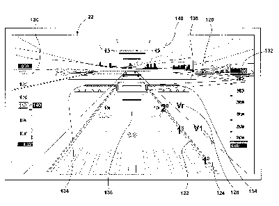
[0022] Specific examples for takeoff and landing may prove useful. Figure 3
illustrates a
forward looking graphical representation 120 including a runway 122 that the
aircraft 10
is about to takeoff on. During takeoff, critical elements of the takeoff roll
of the aircraft
6
CA 02841419 2014-01-30
263619
are the point at which thrust acceleration is achieved and the aircrafts
position on the
departure runway. Thrust acceleration is the point where the engine power is
increased,
with the advancement of the thrust levers, thrust becomes greater than drag
and the
airspeed increases. If thrust is advanced too slowly, the aircraft 10 will
have traveled
down a portion of the runway beyond a point to safely abort the takeoff below
V1
without causing damage. Thus, the current aircraft position as it is traveling
down the
runway may be illustrated through the forward looking graphical representation
120
along with a variety of situational awareness information. The graphical
representation
may take any suitable form including that the forward looking graphical
representation
120 may include a depiction of the runway 122 as it would appear with clear
visibility.
[0023] In the illustrated example, the situational awareness information
includes a VI
speed indicator at 124 and a Vr speed indicator at 126. The V1 speed indicator
124 and
the Vr speed indicator 126 are shown on the screen, relative to the runway, at
the location
where the aircraft 10 needs to reach these speeds. The V1 speed indicator 124
indicates
the last point where a stop can be initiated by the pilot, which may be
referred to as the
Go/No Go point. Typically engine failure below this speed should result in an
aborted
takeoff; above this speed the takeoff run should be continued. The Vr speed
indicator
126 indicates the point where the speed of the aircraft 10 should be at a
point where the
nose wheel leaves the ground. This speed cannot be less than V1 or less than
1.05 times
the minimum control speed in the air.
[0024] It is also contemplated that the situational information may include a
V2 speed
indicator. The V2 speed is the takeoff safety speed. At the takeoff safety
speed, if the
aircraft loses an engine, this is the speed at which the aircrafts maintain
and climbs out to
clear a thirty five foot obstacle.
[0025] The situational awareness information is displayed on the graphical
representation
so that the pilot may better associate the information with the movement of
the aircraft
10. All of the situational information may be displayed on the graphical
representation of
the runway and with any airline or operations limits taken into account. For
example, the
7
CA 02841419 2014-01-30
263619
situational awareness information may be displayed with respect to an
appropriate 60%
of the runway for departure, which is typically allowed for the aircraft to
accelerate to V1
and leaves 40% of the runway to stop.
[0026] Further, information may also be included on the flight display 22
including that
some of the additional information may be displayed on the graphical
representation 120.
For example, an air speed indicator 130 and an altitude indicator 132, which
are all
illustrated as scales, may be included. Conventional aircraft symbols 134, a
ladder 136
that represents a pitch scale, an artificial horizon line 138, and a roll
scale 140 may also
be displayed.
[0027] Embodiments of the invention may also alert the pilot to at least one
of a location
of the aircraft on the runway and an unacceptable velocity speed of the
aircraft. For
example, the alert may indicate that the aircraft 10 is not in a safe position
based on a
thrust and aircraft speed of the aircraft 10. For example, a visual or aural
alert in the
cockpit 12 may alert the pilot if the aircraft is too far down the runway for
a successful
rejected takeoff maneuver. This may aid in preventing excessive aircraft
damage.
[0028] Figure 4 illustrates another embodiment of an exemplary flight display
22
illustrating a forward looking graphical representation 150 including a runway
152 that
the aircraft 10 is about to land on. The situational awareness information
displayed
includes a Vref speed indicator 154 and a touchdown zone indicator 156. The
Vref speed
indicator 154 illustrates the Vref speed or the speed the aircraft 10 should
be decelerated
to when it is crossing over the threshold 158. It may also be referred to as
the landing
reference speed or threshold crossing speed. For example, it may be 1.3 times
the stall
speed in landing configuration. The aircraft 10 should maintain this speed
until it touches
down in the touchdown zone 156. The touchdown zone indicator 156 may be any
suitable indicator or indicia to alert the pilot to the touchdown zone, which
is an area that
should be utilized for touch down for a safe landing. If an aircraft is beyond
the
touchdown zone 156 then a missed approach maneuver should be initiated. As
with the
8
CA 02841419 2014-01-30
263619
=
takeoff scenario, the location determination, graphical representation and the
situational
awareness information may be updated on the flight display as the aircraft
moves.
[0029] It is also contemplated that a user in the cockpit 12 may be alerted as
to the
location of the aircraft with respect to the runway on which it is to land.
For example, the
alert may indicate the aircraft should perform a go around procedure as
indicated in
Figure 5 at 170. This may be determined by the controller 30 based on the Vref
speed
and the location of the aircraft. In the illustrated example, the aircraft 10
should go
around because the speed of the aircraft is much greater than the Vref speed
and the
aircraft 10 is too far down the runway 152. Going around will allow the
aircraft 10 to
safely touchdown and decelerate prior to the end of the runway 152.
Alternatively, an
alert may be displayed that may indicate that the aircraft is traveling above
the Vref
speed. Further still, an alert may be displayed that indicates the aircraft 10
will
undershoot the touchdown zone or that indicates that the aircraft 10 has
traveled beyond
the touchdown zone 156.
[0030] The above described embodiments provide a variety of benefits including
that the
pilot may make a more accurate assessment of the takeoff or landing situation.
The
technical effect of the embodiments of the invention being that the pilot is
presented with
a graphical representation of the runway on which it is to take off or land
and situational
awareness information is shown to allow pilots to more easily and immediately
identify
threats and mitigate these threats. This may subsequently result in a reduced
number of
rejected takeoff related accidents by improving the pilot's decision making
through
increased knowledge. Further, this may result in a reduced number of overrun
incidents
during the landing phase of flight.
[0031] While there have been described herein what are considered to be
preferred and
exemplary embodiments of the present invention, other modifications of these
embodiments falling within the scope of the invention described herein shall
be apparent
to those skilled in the art.
9