Note: Descriptions are shown in the official language in which they were submitted.
CA 02842161 2015-09-04
METHOD AND SYSTEM OF DISPLAYING DATA ASSOCIATED WITH
DRILLING A BOREHOLE
BACKGROUND
[0001] To obtain hydrocarbons such as oil and gas, boreholes are drilled by
rotating a drill bit attached to a drill string. The drill bit is mounted on
the lower end
of the drill string as part of a bottomhole assembly (BHA) and is rotated by
rotating the drill string at the surface, by actuation of downhole motors, or
both.
With weight applied by the drill string, the rotating drill bit engages the
earth
formation and forms a borehole toward a target zone.
[0002] A number of downhole devices placed in close proximity to the drill bit
measure downhole operating parameters associated with the drilling and
downhole conditions. Such devices may include sensors for measuring downhole
temperature and pressure, azimuth and inclination of the borehole, and
formation
parameter-measuring devices. The recited information and other information
(such as rotational speed of the drill bit and/or the drill string, and
drilling fluid flow
rate) may be provided to the drilling operator so that drilling plan may be
implemented.
[0003] Providing information to the drilling operator requires the operator to
consider many variables, some interrelated, when making decisions regarding
implementing the drilling plan.
[0004] However, the ability to consider and alter a large number of variables
can
prove difficult for a drilling operator, particularly when the variables are
presented
in a disparate manner.
BRIEF DESCRIPTION OF THE DRAWINGS
[0005] For a detailed description of exemplary embodiments, reference will now
be made to the accompanying drawings in which:
CA 02842161 2014-01-16
WO 2013/015958
PCT/US2012/045415
2
[0006] Figure 1 shows an offshore drilling system in accordance with at least
some embodiments;
[0007] Figure 2 shows a land-based drilling system in accordance with at least
some embodiments;
[0008] Figure 3 shows a method in accordance with at least some
embodiments;
[0009] Figure 4 shows a plot on a display device in accordance with at least
some embodiments;
[0010] Figure 5 shows a portion of a plot in accordance with at least some
embodiments;
[0011] Figure 6 shows a plot in accordance with at least some embodiments;
[0012] Figure 7 shows a plot on a display device in accordance with at least
some embodiments; and
[0013] Figure 8 shows a computer system in accordance with at least some
embodiments.
NOTATION AND NOMENCLATURE
[0014] Certain terms are used throughout the following description and claims
to
refer to particular system components. As one skilled in the art will
appreciate,
different companies may refer to a component by different names. This
document does not intend to distinguish between components that differ in name
but not function.
[0015] In the following discussion and in the claims, the terms "including"
and
"comprising" are used in an open-ended fashion, and thus should be interpreted
to mean "including, but not limited to... ." Also, the term "couple" or
"couples" is
intended to mean either an indirect or direct connection. Thus, if a first
device
couples to a second device, that connection may be through a direct connection
or through an indirect connection via other devices and connections.
[0016] "Borehole" shall mean a hole drilled into the Earth's crust used
directly or
indirectly for the exploration or extraction of natural resources, such as
oil, natural
gas or water.
462218.01/2149-03501
CA 02842161 2014-01-16
WO 2013/015958
PCT/US2012/045415
3
[0017] "Controllable parameter" shall mean a parameter whose values may be
directly or indirectly controlled during the drilling process (e.g.,
rotational speed of
a drill bit, drilling fluid flow rate, weight-on-bit).
[0018] "Real-time", with respect to calculations based on underlying data,
shall
mean that the calculations are completed within six minutes of reading the
underlying data.
[0019] "Remote" shall mean greater than one mile from a designated location.
[0020] "Surface", in reference to the surface of the Earth, shall mean any
location starting 10 feet below the ground and extending upward relative to
the
local force of gravity.
DETAILED DESCRIPTION
[0021] The following discussion is directed to various embodiments of the
invention. Although one or more of these embodiments may be preferred, the
embodiments disclosed should not be interpreted, or otherwise used, as
limiting
the scope of the disclosure, including the claims. In addition, one skilled in
the art
will understand that the following description has broad application, and the
discussion of any embodiment is meant only to be exemplary of that embodiment,
and not intended to intimate that the scope of the disclosure, including the
claims,
is limited to that embodiment.
[0022] The various embodiments are directed to methods and systems of
displaying information for use during drilling of a borehole, and in some
cases
methods and systems of automating the drilling process. The specification
first
turns to a description of illustrative systems, and then provides a more
detailed
explanation of operation of various embodiments within the illustrative
systems.
[0023] Figure 1 shows an example subsea drilling operation. In particular,
Figure 1 shows a bottomhole assembly 100 for a subsea drilling operation,
where
the bottomhole assembly 100 illustratively comprises a drill bit 102 on the
distal
end of the drill string 104. Various logging-while-drilling (LWD) and
measuring-
while-drilling (MWD) tools may also be coupled within the bottomhole
assembly 100. The distinction between LWD and MWD is sometimes blurred in
the industry, but for purposes of this specification and claims LWD tools
measure
462218.01/2149-03501
CA 02842161 2014-01-16
WO 2013/015958
PCT/US2012/045415
4
properties of the surrounding formation (e.g., resistivity, porosity,
permeability),
and MWD tools measure properties associated with the borehole (e.g.,
inclination, and direction). In the example system, a logging tool 106 may be
coupled just above the drill bit, where the logging tool may read data
associated
with the borehole 108 (e.g., MWD tool), or the logging tool 106 may read data
associated with the surrounding formation (e.g., a LWD tool). In some cases,
the
bottomhole assembly 100 may comprise a mud motor 112. The mud motor 112
may derive energy from drilling fluid flowing within the drill string 104 and,
from
the energy extracted, the mud motor 112 may rotate the drill bit 102 (and if
present the logging tool 106) separate and apart from rotation imparted to the
drill
string by surface equipment. Additional logging tools may reside above the mud
motor 112 in the drill string, such as illustrative logging tool 114.
[0024] The bottomhole assembly 100 is lowered from a drilling platform 116 by
way of the drill string 104. The drill string 104 extends through a riser 118
and a
well head 120. Drilling equipment supported within and around derrick 123
(illustrative drilling equipment discussed in greater detail with respect to
Figure 2)
may rotate the drill string 104, and the rotational motion of the drill string
104
and/or the rotational motion created by the mud motor 112 causes the bit 102
to
form the borehole 108 through the formation material 122. The volume defined
between the drill string 104 and the borehole 108 is referred to as the
annulus 125. The borehole 108 penetrates subterranean zones or reservoirs,
such as reservoir 110, believed to contain hydrocarbons in a commercially
viable
quantity.
[0025] In accordance with at least some embodiments, the bottomhole
assembly 100 may further comprise a communication subsystem. In particular,
illustrative bottomhole assembly 100 comprises a telemetry module 124.
Telemetry module 124 may communicatively couple to the various logging
tools 106 and 114 and receive logging data measured and/or recorded by the
logging tools 106 and 114. The telemetry module 124 may communicate logging
data to the surface using any suitable communication channel (e.g., pressure
pulses within the drilling fluid flowing in the drill string 104, acoustic
telemetry
through the pipes of the drill string 104, electromagnetic telemetry, optical
fibers
462218.01/2149-03501
CA 02842161 2015-09-04
embedded in the drill string 104, or combinations), and likewise the telemetry
module 124 may receive information from the surface over one or more of the
communication channels.
[0026] Figure 2 shows an example land-based drilling operation. In particular,
Figure 2 shows a drilling platform 200 equipped with a derrick 202 that
supports a
hoist 204. The hoist 204 suspends a top drive 208, the hoist 204 and top drive
rotate and lower the drill string 104 through the wellhead 210. Drilling fluid
is
pumped by mud pump 214 through flow line 216, stand pipe 218, goose neck
220, top drive 208, and down through the drill string 104 at high pressures
and
volumes to emerge through nozzles or jets in the drill bit 102. The drilling
fluid
then travels back up the wellbore via the annulus 125, through a blowout
preventer (not specifically shown), and into a mud pit 224 on the surface. On
the
surface, the drilling fluid is cleaned and then circulated again by mud pump
214.
The drilling fluid is used to cool the drill bit 102, to carry cuttings from
the base of
the borehole to the surface, and to balance the hydrostatic pressure in the
rock
formations.
[0027] In the illustrative case of the telemetry module 124 encoding data in
pressure pulses that propagate to the surface, one or more transducers, such
as
transducers 232, 234 and/or 236, convert the pressure signal into electrical
signals for a signal digitizer 238 (e.g., an analog-to-digital converter).
While three
transducers 232, 234 and/or 236 are illustrated, a greater number of
transducers,
or fewer transducers, may be used in particular situations. The digitizer 238
supplies a digital form of the pressure signals to a surface computer 240 or
some
other form of a data processing device. Surface computer 240 operates in
accordance with software (which may be stored on a computer-readable storage
medium) to monitor and control the drilling processing, including instructions
to
process and decode the received signals related to telemetry from downhole.
The surface computer 240 is communicatively coupled to many devices in and
around the drilling site, and such communicative couplings are not shown so as
not to unduly complicate the discussion.
[0028] In some cases, data gathered from in and around the drill site, as well
as
the logging data sent by the telemetry module 124, may be displayed on a
display
CA 02842161 2014-01-16
WO 2013/015958
PCT/US2012/045415
6
device 241 (display techniques discussed more below). In yet still other
example
embodiments, the surface computer 240 may forward the data to another
computer system, such as a computer system 242 at the operations center of the
oilfield services provider, the operations center remote from the drill site.
The
communication of data between computer system 240 and computer system 242
may take any suitable form, such as over the Internet, by way of a local or
wide
area network, or as illustrated over a satellite 244 link. Some or all of the
calculations associated with controlling the drilling may be performed at the
computer system 242. The specification now turns to displaying drilling status
and/or controlling the drilling in accordance with at least some embodiments.
[0029] The various embodiments were developed in the context of controlling
rate-of-penetration (ROP) of the drill bit through earth formations. The
discussion
that follows is based on the developmental context; however, the developmental
context and related discussion shall not be read as a limitation as to the
scope of
the various claims below. The techniques discussed in terms of rate-of-
penetration find applicability to any of a variety of drilling parameters.
[0030] The drilling of the borehole may proceed through various types of
formations. It follows that the downhole operating conditions change over
time,
and the drilling operator reacts to such changes by adjusting controllable
parameters. Example controllable parameters comprise weight-on-bit (WOB),
drilling fluid flow through the drill pipe (flow rate and pressure),
rotational speed of
the drill string (e.g., rotational rate applied by the top drive unit), and
the density
and viscosity of the drilling fluid. Thus, in drilling operations, the
drilling operator
continually adjusts the various controllable parameters in an attempt to
increase
and/or maintain drilling efficiency. Moreover, even with a particular
formation,
adjustments may be needed to increase and/or maintain drilling efficiency.
[0031] Illustrative surface computer 240 couples to the display device 241 and
displays on the display device a graphic for visually tracking the drilling
operations. In some embodiments, various aspects are executed within an
integration and visualization platform, such as surface computer 240 executing
DecisionSpace0 available from Halliburton Energy Services, Inc. of Houston,
Texas. The integration and visualization platform receives indications of
downhole
462218.01/2149-03501
CA 02842161 2014-01-16
WO 2013/015958
PCT/US2012/045415
7
operating conditions and controllable parameters (e.g., weight-on-bit, fluid
flow
rate, and bit speed). The surface computer 240 also sends control signals to
change various controllable parameters (e.g., weight-on-bit, drilling fluid
flow rate,
and bit speed).
[0032] In accordance with various embodiments, software plug-in 280 may be
installed and executed by the surface computer 240 along with the integration
platform. In other cases, the functionality of the plug-in 280 may be:
incorporated
into the integration platform; executed on the remote computer system 242; or
the
functionality spread among the available computer systems. The plug-in 280 may
be stored in, for example, one or more computer-readable mediums. Figure 3
shows a method that may be implemented, in whole or in part, by the plug-in
280.
In particular, the method starts (block 300) and proceeds to reading data
associated with the drilling of the borehole (block 302). Inasmuch as the
information is to be provided to the drilling operator and is to be used to
control an
ongoing drilling process, the reading of the data is during the drilling
process, and
at least one datum of the data is based on a controllable parameter (e.g.,
weight-
on-bit, fluid flow rate, and bit speed). The illustrative method then proceeds
to
calculating an operational value related to drilling the borehole, the
operational
value based on the data (block 304). For example, calculating the operational
value may involve calculating a current rate-of-penetration for the drilling
process.
Here again, since the operational value is to be provided to the drilling
operator
for use in controlling an ongoing drilling process, the calculating is in real-
time
with reading of the data.
[0033] Still referring to Figure 3, the next step in the illustrative method
implemented by the plug-in 280 is determining a target value of the
operational
value (block 306), the target value based at least in part on the data
associated
with the drilling process. In the example case of the operational value being
current rate-of-penetration, the target value may be a target rate-of-
penetration,
including target values for each controllable parameter that affects rate-of-
penetration (e.g., weight-on-bit, fluid flow rate, and rotational speed). As
yet
another example, the target value may be calculated to reduce mechanical
specific energy, reduce hydro-mechanical specific energy, or to reduce overall
462218.01/2149-03501
CA 02842161 2014-01-16
WO 2013/015958
PCT/US2012/045415
8
cost of drilling the borehole. In the specific example of rate-of-penetration
as the
operational value, the target value may be a target rate-of-penetration that
reduces another value (e.g., surface energy consumption), and thus the target
value need not always be calculated to optimize the operational value itself.
Here
again with respect the target value, since (as discussed more below) the
target
value is to be provided to the drilling operator for use in controlling an
ongoing
drilling process, the calculating of the target value is in real-time with
reading of
the underlying data. In some embodiments, multiple versions of the
illustrative
method may be executing simultaneously, each method providing respective
information regarding respective (but distinct) operational values. In this
way, the
operator may view multiple results to ascertain patterns (e.g., both methods
indicate a similar change desirable).
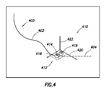
[0034] The illustrative method then proceeds to displaying a first borehole
trajectory on a display device (block 308). That is, to aid the drilling
operator in
visualizing the current state of drilling the borehole, the computer system
240
illustratively executing the plug-in 280 may display on the display device 241
a
depiction of the borehole trajectory, as illustrated in Figure 4. In
particular,
Figure 4 shows a view of a borehole trajectory 400 that may be shown on the
display device 241. In some cases, the borehole trajectory 400 may comprise an
indication of the portion of the borehole that has already been drilled (in
Figure 4
by portion 402 shown with a solid line), and also an indication of the
expected
future path of the borehole that has yet to be drilled (in Figure 4 by portion
404
shown with a dashed line). In other cases, the expected future path may be
omitted from the display. In some embodiments, the borehole trajectory 400 may
be a three-dimensional representation of the borehole, and thus the three-
dimensional representation may be projected onto the two-dimensional surface
of
the display device in such a way as to appear to the drilling operator as
three-
dimensional. In other cases, the borehole trajectory 400 may be a two-
dimensional representation displayed on the display device 241.
[0035] Referring simultaneously to Figures 3 and 4, the illustrative method
may
further comprise superimposing a coordinate system over the borehole
trajectory
on the display device (block 310). In some cases, the superimposed coordinate
462218.01/2149-03501
CA 02842161 2014-01-16
WO 2013/015958
PCT/US2012/045415
9
system may reside proximate to a distal end of the borehole trajectory. Figure
4
illustratively shows a three-dimensional coordinate system 410 superimposed
over the distal end 412 of the borehole trajectory (e.g., the current distal
end of
the borehole, not necessarily the planned ultimate distal end of the borehole
trajectory). In other cases, a two-dimensional coordinate system may be used.
In accordance with at least some embodiments, the coordinate system 410 has at
least one non-spatial axis, and in some cases each axis is a non-spatial axis.
Stated oppositely, in some embodiments there are no spatial axes in the
coordinate system 410. Thus, the path of borehole trajectory 400, being a
spatial
path, may be considered to be plotted against a spatial coordinate system
(which
spatial coordinate system may or may not be specifically shown), and the
coordinate system 410 is separate and apart from any spatial coordinate system
for the borehole trajectory 410.
[0036] The illustrative method may further comprise plotting, within the
coordinate system, an indication of the operational value and an indication of
the
target value (block 312). In Figure 4, the target value is illustratively
plotted as
ball or dot 414, and the target value is illustratively plotted as a ball or
dot 416.
Figure 4 thus shows an example situation where there is a difference between
the operational value as calculated, and the target value. Consider the
example
situation of rate-of-penetration. Rate-of-
penetration may be controlled by
parameters such as weight-on-bit, rotational speed of the drill bit, and
drilling fluid
flow rate. Thus, in
accordance with these embodiments the coordinate
system 410 has a weight-on-bit axis 418, a rotational speed of the drill bit
axis 420, and a drilling fluid flow rate axis 422. The dot 414 showing the
current
operational value in the form a rate-of-penetration may thus be plotted within
the
coordinate system 410 at a location that corresponds to the weight-on-bit,
rotational speed of the drill bit, and drilling fluid flow rate that provides
the current
rate-of-penetration. The target value in this example situation is shown by
dot 416, which dot 416 is plotted in the coordinate system 410 at a weight-on-
bit,
rotational speed of the drill bit, and drilling fluid flow rate that, if
utilized, should
provide the target rate-of-penetration.
462218.01/2149-03501
CA 02842161 2014-01-16
WO 2013/015958
PCT/US2012/045415
[0037] Figure 5 shows a plot being a portion of the view of Figure 4, but in
greater detail. In particular, Figure 5 shows the operational value dot 414
plotted
at a location within the coordinate system 410 corresponding to the parameters
that make up the operational parameter. In the illustrative case of the
operational
value being rate-of-penetration, dot 414 represents a rate of penetration
based
on: the current weight-on-bit plotted with respect to the weight-on-bit axis
418; the
current rotational speed of the drill bit with respect to the rotational speed
axis 420; and the current drilling fluid flow rate with respect to the
drilling fluid flow
rate axis 422. In the illustrative situation of Figure 5, the target value
plotted as
dot 416 is different than the operational value, and the target value dot 416
plotted at a location within the coordinate system 410 corresponding to the
parameters that should be required to make the operational parameter value
match the target value. Again in the illustrative case of Figure 5, the target
value
should be achieved with the current weight-on-bit (i.e., the operational value
and
target value share a weight-on-bit plotted point, but with increases in both
rotational speed and drilling fluid flow rate).
[0038] The illustrative coordinate system has three non-spatial axes; however,
an additional dimension may be encoded in the visual display in the form of a
recognizable artifact. Still referring to Figure 5, the magnitude of the
calculated
operational value may be shown in the form of the size of the dot 414. In the
illustrative case of Figure 5, the target value is greater than the current
operational value, and the size of the dot 416 is increased. Stated otherwise,
an
additional dimension of information is thus encoded in the size of the dots
plotting
the operational value and target value. Other recognizable artifacts include
differences in color, shape, opacity, or combinations. Further still, the
magnitude
of the current operational value may be displayed in number form in, on,
around
or near the plotted dot.
[0039] Thus, by viewing the coordinate system 410 associated with the
borehole trajectory 400 plotted on the display device 241, the drilling
operator is
provided a wealth of information regarding the drilling processing, and can
choose one or more controllable parameters for adjustment in an attempt to
have
the operational value move toward target value. In the illustrative case of
the
462218.01/2149-03501
CA 02842161 2014-01-16
WO 2013/015958
PCT/US2012/045415
11
operational value being rate-of-penetration in the example of Figure 5, the
drilling
operation may increase rotational speed of the bit, and likewise increase
drilling
fluid flow rate. In yet still other cases, the plug-in 280, implementing
the
illustrative method of Figure 3, may determine the difference between the
parameters that make up the location of the current operational value and the
parameters that, if used, should cause the system to achieve the target value,
and automatically adjust one or more controllable parameters (i.e., adjust one
or
more of the controllable parameters without input from the human drilling
operator) (block 314). Thereafter, the method may end (block 316), in most
cases to be immediately restarted for the next incremental depth and/or length
of
the borehole. As an example of the automatic adjustment, the plug-in 280 may
implement one or more proportional-integral-differential (PID) control loops
(e.g.,
one for each controllable parameter), which PID control loops continually
adjust
the controllable parameters in an attempt to have the operational value match
the
target value. In yet still further cases, the plug-in 280 may suggest to the
drilling
operator a change in one or more controllable parameters, and have the
drilling
operator make the changes after application of human intuition.
[0040] In accordance with various embodiments, as the actual drilled length of
the borehole increases, so too does the length of the depiction of the
borehole
trajectory 400 on the display device. As the length of the borehole trajectory
increases, the coordinate system moves relative to the borehole trajectory. In
some cases, the coordinate system may remain at a fixed location on the
display
device 241, and the depiction of the borehole trajectory shifts. In other
cases,
previously plotted portions of the borehole trajectory 400 remain at
stationary
locations on the display device, and the coordinate system 410 moves to the
new
distal end of the borehole trajectory. In some cases, the plotted indications
of the
operational value and target value are removed and re-plotted with each new
location of the coordinate system 410 relative to the borehole trajectory 400.
However, in yet still other cases, older plotted operational value and target
value
are left in place (or re-plotted within the new location of the coordinate
system
relative to the borehole trajectory) such that the change over time in the
values
may be observed by the drilling operator. Figure 6 shows a plot being a
portion of
462218.01/2149-03501
CA 02842161 2014-01-16
WO 2013/015958
PCT/US2012/045415
12
what may displayed on a display device 241 by the plug-in 280 in yet still
further
embodiments. In particular, Figure 6 shows a series of plotted dots, where the
upper dots 600 represent previous operational values, and the lower dots 602
represent previous target values. Stated otherwise, the plug-in 280 in these
embodiments may refrain from removing previous plotted values from the display
device 241. Viewing a scene including the previous plotted values as in Figure
6
thus provides feedback to the drilling operator as to how well previous
changes to
controllable parameters are affecting the operational value relative to the
target
value. The specification now turns to use of actual values from nearby wells.
[0041] While in some embodiments the plug-in 280 operates with data collected
solely with respect the borehole being drilled, in other embodiments data
related
to other boreholes (e.g., boreholes whose drilled length is longer the current
borehole being drilled, or perhaps boreholes whose drilling has been
completed)
may be used in various ways. Figure 7 shows a plot that may be displayed on
the display device 241 in accordance with at least some embodiments. In
particular, Figure 7 shows the borehole trajectory 400 for the current
borehole
being drilled, along with a coordinate system 410, in this case illustratively
shown
as a cube (e.g., a three-dimensional coordinate system). Co-plotted on the
same
display is a borehole trajectory for a nearby borehole 700, including a
coordinate
system 702 (also illustrative shown as a cube). Thus, in some embodiments the
method executed by the plug-in 280 may include scanning one or more
databases of information for the presence of nearby boreholes that are being
drilled or have been drilled. For example, the plug-in 280 may access a
database
on the computer system 242 at the operations center for the service provider.
[0042] More particularly, the plug-in 280 may determine the proximity of
nearby
boreholes that have already drilled through the formation material which is or
is
about to be drilled by the current borehole. The idea being that the actual
values
associated with the nearby borehole may provide a better set of target value
for
the current borehole than the plug-in 280 could create based on models or
characteristic equations. For example, if the borehole associated with
borehole
trajectory 700 has already drilled though a target shale formation, the actual
rates-of-penetration achieved in the nearby borehole may be a better
indication of
462218.01/2149-03501
CA 02842161 2014-01-16
WO 2013/015958
PCT/US2012/045415
13
how to set controllable parameters in the current borehole. Thus, in these
embodiments the plug-in 280 may show the borehole trajectory 700, coordinate
system 702, as well as a plot or dot 704 indicative of the actual value
achieved in
the nearby borehole. The drilling operation may thus use the indications of
the
controllable parameters from the nearby borehole as a guide to setting the
controllable parameters in the current borehole to achieve the target value.
In yet
still other cases, rather than calculating a target value regarding the
current
borehole, the plug-in 280 may instead plot within the coordinate system 410
associated with the current wellbore the actual value achieved in the nearby
borehole as the target value.
[0043] Again using the rate-of-penetration as a guide, the plug-in 280 may
scan
one or more data bases for nearby boreholes, and in some cases the radius or
other distance criteria may be selectable (e.g., along a mineral lease line).
If a
nearby well meets the distance criteria, the plug-in 280 may find data
regarding a
corresponding depth, and the actual rate-of-penetration achieved (including
the
values of the controllable parameters used). The plug-in 280 may then
substitute
the actual rate-of-penetration from the nearby well to be the target value in
the
current borehole, and plot the target value rate-of-penetration along with the
operational value rate-of-penetration in the coordinate system 410.
[0044] Numerous variations and modifications to the illustrative system are
possible. For example, the number of dimensions shown on the coordinate
system 410 is not limited to two or three, and thus the coordinate system may
be
an n-dimensional space. Four or more dimensions may be plotted as the
dimensions need not be orthogonally related. The system may be operated in
the "scan mode" ¨ scanning for nearby boreholes such that actual values from
those nearby wells may be used ¨ or the system may be operated where only the
data related to the current borehole is used. The previously plotted
operational
values and target values may be animated in a repeating loop to show the
progression over time. The system may enable the drilling operator to "play
back"
the drilling situation starting from any previous depth or time to any target
depth
or time, including the present.
462218.01/2149-03501
CA 02842161 2014-01-16
WO 2013/015958
PCT/US2012/045415
14
[0045] In yet still other cases, the target value calculated and displayed may
be
a limit value. That is, in these embodiments rather than calculating a target
values (e.g., an optimized rate-of-penetration), the target value may merely
plot a
limit to the operational value (e.g., a maximum limit, minimum limit,
deviation
limit).
[0046] Further still, while the various embodiments have been described in
relation to the various calculations being performed at the surface, in yet
still
further cases some or all calculations regarding the operational value and/or
the
target value may be performed by a processor disposed within the borehole
proximate to the drill bit. For example, the telemetry module 124 may be a
computer system (controlling an encoding system, such as a mud pulser). The
computer system associated with the telemetry module 124 may calculate the
various parameters, and telemeter the some or all the parameters to the
surface
computer systems. In cases where control of the operational parameter is
automated, the telemetry module 124 (or some other sub-surface computer
system) may control or change one or more controllable parameters (e.g., speed
of the mud motor 112, or weight-on-bit in systems where weight-on-bit is
controllable downhole).
[0047] Figure 8 illustrates a computer system 800 in accordance with at least
some embodiments. Computer system 800 is illustrative of a computer system
upon which some or all of the various methods may be performed. For example,
computer system 800 may be illustrative of computer system 240 or 242.
Moreover, in slightly reduced form (e.g., without the graphics capability,
network
interface card, and input/output devices), computer system 800 may be
representative of a computer system disposed with telemetry module 124. In
particular, computer system 800 comprises a main processor 810 coupled to a
main memory array 812, and various other peripheral computer system
components, through integrated host bridge 814. The main processor 810 may
be a single processor core device, or a processor implementing multiple
processor cores. Furthermore, computer system 800 may implement multiple
main processors 810. The main processor 810 couples to the host bridge 814 by
way of a host bus 816, or the host bridge 814 may be integrated into the main
462218.01/2149-03501
CA 02842161 2014-01-16
WO 2013/015958
PCT/US2012/045415
processor 810. Thus, the computer system 800 may implement other bus
configurations or bus-bridges in addition to, or in place of, those shown in
Figure 8.
[0048] The main memory 812 couples to the host bridge 814 through a memory
bus 818. Thus, the host bridge 814 comprises a memory control unit that
controls
transactions to the main memory 812 by asserting control signals for memory
accesses. In other embodiments, the main processor 810 directly implements a
memory control unit, and the main memory 812 may couple directly to the main
processor 810. The main memory 812 functions as the working memory for the
main processor 810 and comprises a memory device or array of memory devices
in which programs, instructions and data are stored. The main memory 812 may
comprise any suitable type of memory such as dynamic random access memory
(DRAM) or any of the various types of DRAM devices such as synchronous
DRAM (SDRAM), extended data output DRAM (EDODRAM), or Rambus DRAM
(RDRAM). The main memory 812 is an example of a non-transitory computer-
readable medium storing programs and instructions, and other examples are disk
drives and flash memory devices.
[0049] The illustrative computer system 800 also comprises a second
bridge 828 that bridges the primary expansion bus 826 to various secondary
expansion buses, such as a low pin count (LPC) bus 830 and peripheral
components interconnect (PCI) bus 832. Various other secondary expansion
buses may be supported by the bridge device 828.
[0050] Firmware hub 836 couples to the bridge device 828 by way of the LPC
bus 830. The firmware hub 836 comprises read-only memory (ROM) which
contains software programs executable by the main processor 810. The software
programs comprise programs executed during and just after power on self-test
(POST) procedures as well as memory reference code. The POST procedures
and memory reference code perform various functions within the computer
system before control of the computer system is turned over to the operating
system. The computer system 800 further comprises a network interface card
(NIC) 838 illustratively coupled to the PCI bus 832. The NIC 838 acts to
couple
462218.01/2149-03501
CA 02842161 2015-09-04
16
the computer system 800 to a communication network, such the Internet, or
local--
or wide-area networks.
[0051] Still referring to Figure 8, computer system 800 may further comprise a
super input/output (I/0) controller 840 coupled to the bridge 828 by way of
the
LPC bus 830. The Super I/0 controller 840 controls many computer system
functions, for example interfacing with various input and output devices such
as a
keyboard 842, a pointing device 844 (e.g., mouse), a pointing device in the
form
of a game controller 846, various serial ports, floppy drives and disk drives.
The
super I/0 controller 840 is often referred to as "super" because of the many
I/0
functions it performs.
[0052] The computer system 800 may further comprise a graphics processing
unit (GPU) 850 coupled to the host bridge 814 by way of bus 852, such as a
Peripheral Component Interconnect Express (PCI Express or PCI-E) bus or
Accelerated Graphics Port (AGP) bus. Other bus systems, including after-
developed bus systems, may be equivalently used. Moreover, the graphics
processing unit 850 may alternatively couple to the primary expansion bus 826,
or
one of the secondary expansion buses (e.g., PCI bus 832). The graphics
processing unit 850 couples to a display device 854 which may comprise any
suitable electronic display device upon which any image or text can be plotted
and/or displayed. The graphics processing unit 850 may comprise an onboard
processor 856, as well as onboard memory 858. The processor 856 may thus
perform graphics processing, as commanded by the main processor 810.
Moreover, the memory 858 may be significant, on the order of several hundred
megabytes or more. Thus, once commanded by the main processor 810, the
graphics processing unit 850 may perform significant calculations regarding
graphics to be displayed on the display device, and ultimately display such
graphics, without further input or assistance of the main processor 810.
[0053] Thus, it is upon illustrative computer system 800 that the various
embodiments discussed above may be performed. Moreover, the various
embodiments may be performed by a host of computer systems, such as
computer system 800, operated in a parallel fashion.
CA 02842161 2015-09-04
17
[0054] It is noted that while theoretically possible to perform some or all
the
calculations, simulations, and/or modeling to arrive at the operational values
and/or target values discussed above by a human using only pencil and paper,
the time measurements for human-based performance of such tasks may range
from man-hours to man-years, if not more. Thus, this paragraph shall serve as
support for any claim limitation now existing, or later added, setting forth
that the
period of time to perform any task described herein is less than the time
required
to perform the task by hand, less than half the time to perform the task by
hand,
and less than one quarter of the time to perform the task by hand, where "by
hand" shall refer to performing the work using exclusively pencil and paper.
[0055] From the description provided herein, those skilled in the art are
readily
able to combine software created as described with appropriate general-purpose
or special-purpose computer hardware to create a computer system and/or
computer sub-components in accordance with the various embodiments, to
create a computer system and/or computer sub-components for carrying out the
methods of the various embodiments, and/or to create a non-transitory computer-
readable storage medium (i.e., other than an signal traveling along a
conductor or
carrier wave) for storing a software program to implement the method aspects
of
the various embodiments.
[0056] The above discussion is meant to be illustrative of the principles and
various embodiments of the present invention. Numerous
variations and
modifications will become apparent to those skilled in the art once the above
disclosure is fully appreciated. It is
intended that the following claims be
interpreted to embrace all such variations and modifications.