Note: Descriptions are shown in the official language in which they were submitted.
CA 02843081 2014-02-10
GOOGLE-743
POSITION INDICATION CONTROLS FOR DEVICE LOCATIONS
CROSS-REFERENCE TO RELATED APPLICATIONS
[0001]
BACKGROUND
[0002] The
present disclosure relates generally to the
field of indoor positioning and location-based information
systems, and more specifically to systems and methods for
providing an indication of position and position confidence
near a structure periphery, such as when located proximate an
exterior wall of a structure, when transitioning from an
indoor location (i.e., first positioning system) to an outdoor
location (i.e., second positioning system), and so on.
[0003]
Typical location-based information systems depend on
the global positioning systems (GPS) to determine a geographic
location and a remote database that contains information
associated with a particular geographic location. GPS
receivers generally rely on navigation signals broadcasted by
satellites orbiting the Earth. Such receivers require an
essentially unobstructed line of sight to the satellites in
order to provide reliable location information. Thus, GPS is
typically used to establish locations in outdoor environments
only and may not be suitable to indoor locations. Even in
outdoor locations, the presence of tall buildings, and other
obstructions in the line of sight can preclude GPS
positioning.
Indoor positioning systems (IFS) have been
developed for use within indoor environments, such as office
buildings. Such systems generally use various wireless
-1-
WO 2013/078125 CA 02843081 2014-02-10 PCT/US2012/065819
transmissions, for example, infrared (IR) or ultrasound
signals, for location and tracking purposes.
Devices have
also been configured to utilize other data sources, such as
WiFi signals, Bluetooth, on-board compass and accelerometer
(and/or gyroscope, magnometer, etc.) data, as well as existing
floor plans and databases of measurements. Thus,
geo-
positioning devices are often configured to switch operation
between different geo-positioning systems.
[0004] Indoor
geo-positioning systems have a number of
known limitations. For example, many such systems require
special sensor/transceiver devices and infrastructure to be
deployed with the interior spaces of buildings. Further, many
existing systems fail to provide accurate position
determinations due to the inherent interference limitations
that occur within indoor spaces, and fail to provide any
device orientation determinations. Further still, many
existing systems require significant power consumption on the
part of the mobile device. (For example, a system may require
the mobile device to enable its GPS function or continually
transmit a signal in order to determine its position.) Still
further, certain systems require map or measurement data where
none exist (e.g., a building has not been mapped or measured,
nor its floor plan uploaded).
[0005] In one
approach, a map of signal features of a
structure is created, such as a grid of points, each point
including a list of WiFi access points accessible at that
point and the signal strength of each at that point. When
determining location within the structure, a mobile device,
such as computer-enabled mobile telephone (so-called smart
phone), evaluates accessible WiFi access points and signal
strengths wherever the device currently is compares that the
map. A cluster of "particles" is created, each particle being
a possible location of the mobile device. Each
particle has
associated with it a degree of confidence that the mobile
-2-
WO 2013/078125 CA 02843081 2014-02-10 PCT/US2012/065819
device is at that point. The mean location of the clustered
particles is then determined. The
particle closest to the
mean location is then selected as the location of the client
device.
[0006] The
location of the client device is often indicated
by a dot displayed on a map, indicating position. However, it
is difficult to accurately determine location at the scale of
an indoor location (meter or less), particularly when GPS
positioning systems are unavailable. Therefore, the indicated
mobile device location is actually an indication of the
greatest likelihood of position. In
certain applications, a
circle with the location dot as its center represents the
overall degree of confidence that the indicated location is
the current mobile device location. The smaller the radius of
the circle, the higher the probability that the client device
is located at the indicated dot. Thus,
the radius of the
circle is related to the confidence level in the indicated
client device location. For
this reason, the circle is
referred to as a confidence circle.
[0007] However, when a client device is proximate a
boundary between two different positioning systems, the device
may experience difficulty determining which system to use for
a current position determination and display. For
example,
when a client device is near the perimeter of a structure, the
device may receive positioning data from a relatively higher-
precisions indoor system (e.g., WiFi) as well as a relatively
lower-precision outdoor system (e.g., cell tower
triangulation). This
may result in the device arbitrarily
switching from one system to another - in certain cases
showing the device location jumping back and forth between
first and second positions (e.g., the dot jumping indoors,
then outdoors). For
many reasons, the first and second
positions may be surprisingly far from one another. In
addition, since each positioning system has its own associated
-3-
WO 2013/078125 PCT/US2012/065819
CA 02843081 2014-02-10
accuracy and hence confidence circle, the radius of the
confidence circle may vary when switching between systems in
this way. Again, for many reasons the radius of the
confidence circles at the first and second positions may vary
greatly.
Therefore, there remains a desire for improvements
in the indication of location and confidence the system has in
the location (i.e., location of the client device).
SUMMARY
[0008]
Accordingly, the present disclosure is directed to
systems and methods for providing an indication of a position
and a level of confidence in that position for a client
device, such as displayed on the client device. Where
position and confidence in position are indicated on a
display, these indications relatively smoothly change state,
such as when the client device is at a structure periphery and
when the client device transitions between different
positioning systems.
[0009]
According to one aspect of the disclosure the client
device is configured to display an indication (e.g., dot)
representing its current location, for example in the context
of the displayed map of the vicinity of the device.
Alternatively, the location of the device may be displayed on
a remote device, such as a computer, again superimposed on a
map of the vicinity of the device. When a device is near the
boundary of one position system, such as an indoor positioning
system, delay is introduced into the calculation and display
of position so that the device location indication (dot) is
more stable.
Furthermore, the delay reduces the arbitrary
changes in radius of the confidence circle. Ultimately,
position indication and the radius of the confidence circle
transition more smoothly and accurately.
[0010] According to another aspect of the present
disclosure, the prior position of the client device is
retained for a fixed period of time. If a
more accurate
-4-
WO 2013/078125 PCT/US2012/065819
CA 02843081 2014-02-10
location determination can be made during that time, the new
position is displayed. If
not, the radius of the confidence
circle is slowly expanded around the prior position.
[0011]
According to still another aspect of the present
disclosure, a vector that a mobile device is following from a
first positioning system to a second positioning system may be
used to determine an expect arrival time at the second
position system. If no
position indication can be obtained
using the second positioning system within an expected period
of time, the client device will revert to determining position
based on time (e.g., from an on-board clock) and/or distance
(e.g., from an on-board accelerometer, gyroscope, magnometer,
etc.), using the direction from the vector. The
confidence
circle will reflect the appropriate level of confidence in
this estimation.
[0012] The
above is a summary of a number of the unique
aspects, features, and advantages of the present disclosure.
However, this summary is not exhaustive. Thus,
these and
other aspects, features, and advantages of the present
disclosure will become more apparent from the following
detailed description and the appended drawings.
BRIEF DESCRIPTION OF THE DRAWINGS
[0013] In the drawings appended hereto like reference
numerals denote like elements between the various drawings.
While illustrative, the drawings are not drawn to scale. In
the drawings:
[0014] Fig. 1
is an illustration of the a network in which
a mobile device may access and utilize geo-positioning data
according to the present disclosure.
[0015] Fig. 2
is an illustration of the architecture of a
mobile device in a client-server model in a networked context,
according to an embodiment of the present disclosure.
[0016] Fig. 3
is an illustration of a mobile device with a
geo-positioning indicator rendered on a map of the space at
-5-
WO 2013/078125 CA 02843081 2014-02-10 PCT/US2012/065819
which the mobile device is located, including a confidence
circle, according to an embodiment of the present disclosure.
[0017] Fig. 4 is a map of a space illustrating a grid of
locations for which WiFi or other indoor geo-positioning data
has been obtained and mapped to the space, according to an
embodiment of the present disclosure.
[0018] Fig. 5 is an illustration of a number of particles
that are candidate positions based on an example of data
observed by a mobile device including a confidence circle,
according to an embodiment of the present disclosure.
[0019] Fig. 6 is an illustration of a mapped space,
location indication, and confidence circle within a mapped
structure, according to an embodiment of the present
disclosure.
[0020] Fig. / is an illustration of a mapped space,
location indication, and confidence circle proximate an exit
of the space, showing a jump discontinuity in position and
confidence circle radius.
[0021] Fig. 8 is an illustration of a mapped space,
location indication, and confidence circle proximate an exit
of the space, with location delay and revised confidence
circle, according to an embodiment of the present disclosure.
[0022] Fig. 9 is an illustration of a mapped space, several
location indications and their associated confidence circles
proximate the periphery of the mapped space, illustrating
position control based on data regarding the structure such as
wall and door locations, according to an embodiment of the
present disclosure.
[0023] Fig. 10 is a flow diagram according to an embodiment
of the present disclosure.
[0024] Fig. 11 is another flow diagram according to an
embodiment of the present disclosure.
-6-
WO 2013/078125 CA 02843081 2014-02-10 PCT/US2012/065819
DETAILED DESCRIPTION
[0025] We
initially point out that description of process,
components, equipment, and other details known in the art may
merely be summarized or are omitted so as not to unnecessarily
obscure the details of the present disclosure. Thus,
where
details are otherwise well known, we leave it to the
application of the present disclosure to suggest or dictate
choices relating to those details.
[0026] With
reference to Fig. 1, there is illustrated an
exemplary environment in which the teachings of the present
disclosure may be applied.
Typically, the teachings hereof
are applied in the context of an application running on a
mobile device 10, such as a computationally-enabled mobile
telephone (smart phone), tablet computer, or the like. Mobile
device 10 is configured to utilize global positioning (GPS)
data from a GPS data source 12.
[0027] Mobile
device 10 is further configured for wireless
communication via one or more wireless protocols such as WiFi,
Bluetooth, etc. with one or more wireless access points 14.
In one example, beacon messages from the one or more wireless
access points 14 may be IEEE 802.11 management frames
transmitted by access points to announce themselves to
potential wireless network users. These frames may contain
Service Set Identifiers ("SSID") information as well as
physical layer parameters that assist devices in connecting to
the wireless network.
[0028] Mobile
device 10 may further be configured for
infrared (IR), ultrasound, or other local, short-range
communication, such as with an appropriate base station 16.
Mobile device 10 may further still be configured for cellular
telephone communication, via one or more cellular transmission
"towers".
Finally, mobile device 10 may be communicatively
connected to a server or other computer system 20, by any of a
-7-
WO 2013/078125 CA 02843081 2014-02-10 PCT/US2012/065819
variety of methods and protocols, such that mobile device 10
may be considered a "client" device.
[0029] With
reference to Fig. 2, mobile device 10 may be
configured to include a processor 22, data memory 24, and
instructions memory 26. Mobile device 10 may further include
an electronic display 28 (e.g., a touch-screen), an input
device 30 (e.g., a keyboard, that may be a function performed
by a portion of display 28), and a camera 32. Mobile device
further includes a position component 34 configured to use
various resources to estimate aspects of the position of the
device itself, as discussed further below.
[0030] In a
client-server implementation, mobile device 10
communicates with a server computer 40 via a network 36 for
inter alia assistance in determining device location. Network
36 is typically a wireless network. Server
40 typically
includes a processor 42 and memory 44 containing instructions
46 controlling operation of server 40 as well as data 48
supporting that operation.
[0031] In
certain embodiments, mobile device 10 relies on
data 50 stored in server 40 to assist with determining its
position. For example, server 40 may contain data about a
building space in which the mobile device is located, such as
label identifiers and associated positions, and WiFi signal
strengths at the label positions. GPS or
other positioning
system operable outside of the building may be used to
determine that mobile device 10 is somewhere within the
building.
However, since GPS cannot function within the
building (no line-of-sight to the GPS satellites), GPS cannot
be used to accurately determine location within the building.
However, by communicating with the server and identifying the
labels and WiFi signal strengths in the proximity of mobile
device 10, an estimated position of mobile device 10 may be
determined, particularly when GPS is not available (i.e.,
inside the building).
-8-
WO 2013/078125 CA 02843081 2014-02-10 PCT/US2012/065819
[0032]
Similar techniques may be employed for position
determination in the absence of GPS using Bluetooth signals,
IR, ultrasound, image recognition (using the mobile device's
on-board camera), and so on. It is
assumed for the purposes
of the present disclosure that such other techniques are well
known, and thus are not discussed in detail herein.
[0033] With
reference next to Fig. 3, a mobile device 10 is
illustrated which displays a partial map 60 of an indoor
location in which mobile device 10 is presently located. A
location dot 62 is rendered on map 60 representing an
estimation of the current location of mobile device 10. As
discussed below, the position is merely an estimation, and
there is an associated level of confidence in that estimation.
The level of confidence is indicated by the confidence circle
64. There is a selected (arbitrary) level of confidence that
the actual location of mobile device 10 is within the region
circumscribed by confidence circle 64. Thus, a smaller radius
of confidence circle 64 indicates a higher degree of
confidence that dot 62 represents the actual location of
mobile device 10, and conversely a larger radius indicates a
lesser degree of confidence.
[0034]
Calculation of the radius of the confidence circle
may be made in a number of different ways. In one embodiment,
a map 66 of a space, such as shown in Fig. 4, is populated
with particles 68. Particles 68 generally represent locations
at which known reference values, such as WiFi signal
strengths, from a plurality of sources are known. Thus,
one
method of positioning involves measuring WiFi signal strengths
associated with the sources, and matching the results to map
66. For many reasons, the signal strengths vary over time.
Thus, identifying which particle represents the current mobile
device location involves determining which particle(s) most
likely match the data observed by mobile device 10. Other
sensor data from mobile device 10 may be used in conjunction
-9-
W02013/078125 CA 02843081 2014-02-10 PCT/US2012/065819
with map analysis to increase the certainty with regard to
various possible locations (particles), such as last known
direction, steps or time since last location determination,
and so on. In
addition, particles may be weighted based on
their location, established likelihood of being an actual
location, and so on.
[0035] Fig. 5
is an illustration of a number of particles
that represent candidate positions based on an example of data
observed by mobile device 10. The weighted mean particle is
determined, and assigned to be a center point, point 70 in
this example. As an
alternative to the weighted mean
particle, other particles or calculated points may be used as
a center or location point, with tradeoffs as will be
appreciated. A
confidence circle 72 is shown constructed
around center point 70.
(Typically, only the center point and
confidence circle are rendered on a map for a user, but this
may not always be the case.) The radius of confidence circle
72 is a communication of the uncertainty that mobile device 10
is actually located at position 70. The radius of confidence
circle 72 is determined as two times the standard deviation of
the distance each particle is from the given center particle
(in this case, the weighted mean particle). More precisely,
where w_ is the normalized weight of the i particle and (x,y)
is the location of the weighted mean particle, there are n
particles, and (xõ yi is the position of the ith particle
õ\IIL ____________________________________________
2 iv, = ((x ¨ x,)2 +(y¨ y,)2 )
i=o
[0036] Thus,
the radius of the confidence circle can change
dynamically as the data observed by the mobile device changes.
This is true even when the mean particle does not change. For
example, the radius of the confidence circle increases when
steps are detected, even when the direction of those steps is
unknown. In order to provide a visually useful and appealing
user interface, the location dot and confidence circle may be
-10-
W02013/078125 CA 02843081 2014-02-10 PCT/US2012/065819
present in the context of a map of the structure, such as
illustrated in Fig. 6.
[0037] Providing location and confidence can become
problematic when the mobile device moves from a location at
which high quality position information is available, for
example from a first source or positioning system, to a
location at which low quality position information is
available, for example from a second, different source or
system.
Drastic jumps from a high precision position (small
confidence circle radius) positions to a low precision
position (large confidence circle radius) since the location
dot may jump between positions, and the confidence circle may
also jump around the center point between large and small
radii. This problem may be encountered, for example, when the
mobile device is inside but very close to the exterior of a
building in which there is a high precision position system
but is on the fringe of the coverage of that high precision
system and where the immediate exterior vicinity of that
building is not well serviced by another high precision
system. This can occur in urban cities, where tall structures
can block line-of-sight to the GPS satellites (the "urban
canyon" effect). In the
absence of GPS, mobile devices can
rely on cell tower triangulation, but that method is much
lower precision than the indoor WiFi positioning system.
Another example situation in which this occurs is when the
mobile device leaves an indoor location (high precision) and
moves outside to a location having poor or no GPS coverage.
Still another example situation is where the mobile device
leaves a first, surveyed indoor location (high precision) and
continues to a second, non-surveyed location (low precision).
In these types of cases there is a discontinuity in
positioning data precision, causing jumps in estimated
location and confidence circle diameter as the positioning
data jumps from one system to the other. This is illustrated
-11-
WO 2013/078125 CA 02843081 2014-02-10 PCT/US2012/065819
in Fig. 7, in which the location indication for mobile device
10, located near a doorway on map 66 jumps from dot 70a to dot
70c, and confidence circle jumps from circle 72a of radius rl
to circle 72 of radius r2. This
jump can be back and forth
between the systems, leading to confusion regarding location
and an otherwise undesirable user interface. And,
while a
jump between two possible positions is shown in Fig. /, it
will be appreciated that the device position may jump between
multiple different indicated positions due to the above
precision discontinuity. And
while shown as a relatively
small jump in position and confidence circle radius, it may be
that such a jump is much more drastic, both in location and
radius.
[0038] In
order to reduce the effects of system jumping,
and the consequent jumps in indicated location and confidence
circle size, when a mobile device nears or is at a boundary
between high precision and low precision positioning systems,
the last known high precision (indoor) location is retained.
This location is presented as the current device location
while the accuracy radius grows in two phases. In a
first
phase, while it has not yet been determined (e.g., based on
WiFi scans) whether the device has moved to an outside
location or remains inside, the uncertainty radius is
increased each time a step is taken. When a step has been
taken may be determined from accelerometer, gyroscope, and/or
magnometer data provided by the mobile device itself. This
happens naturally and purposefully based on the re-weighting
of the particles from step detection and the accuracy
calculation. In the second phase, once it is certain that the
mobile device has moved to an outside location, the confidence
circle radius is increased by a certain amount per second (or
other time measure) based on the calculated accuracy of the
location indication. The
transition period ends when a GPS
signal is available and can provide better accuracy or after
-12-
WO 2013/078125 CA 02843081 2014-02-10 PCT/US2012/065819
expiration of a timeout period for the transition (in which
case the last known position may be retained or a new position
assumed to be a transition position). The
retained location
is illustrated at point 70 in Fig. 8, with confidence circle
72a being the original confidence circle, which grows in
radius to circle 72c.
[0039] In
addition to "smoothing" the transition from a
first positioning system (e.g., indoors) to a second position
system (e.g., outdoors), known attributes of the structure may
be considered in determining whether to retain the position of
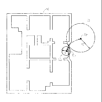
the last known location and if so, for how long. Fig. 9
provides an illustration of this point. In a
first instance,
indicator 80 shows the location of a mobile device (and its
confidence circle 82) proximate an exit 84 of the structure
represented by map 66. It is
therefore reasonable to permit
indicator 80 to move from its current location to a location
outside of the perimeter of map 66, such as position 86 (with
confidence circle 88).
However, in a second instance,
indicator 90 shows the location of the mobile device (and its
confidence circle 92) relatively far from an exit of the
structure. Therefore, any data leading to an indication that
the mobile device has moved directly outside of the perimeter
of the structure, such as indicated by dot 95 and confidence
circle 96 is suspect. This may result, for example, from the
mobile device sensing location data from a lower-precision
system.
[0040] There
are a number of remedies for such a situation
proposed herein. One
such remedy is that there is a
preference for the current state of the weighted mean particle
(location indicator). For
example, each particle may use
position information and data regarding the space in which the
mobile device is located to determine a state of "indoors",
"outdoors", "on level x" (e.g., floor), "following vector y",
and so on. The weight of a preference may be a function of
-13-
WO 2013/078125 CA 02843081 2014-02-10 PCT/US2012/065819
the state. For example if the current location indicator has
an "indoor" state, that preference may be strongly assumed
(particularly if the current location indicator is not
proximate an exit, as discussed below). Whereas an assumption
regarding a vector may have a lower weighting (particularly if
the current location indicator is proximate a path fork).
[0041]
Another remedy for such a situation disclosed herein
is the introduction of a delay in re-rendering the location
indicator when such a re-rendering would put the indicator in
an invalid state (e.g., across a barrier without an associated
exit or portal, within a wall or partition, on another level
or floor in the absence of stairs, elevator, escalator or the
like, and so on).
[0042] Still
another remedy for such a situation disclosed
herein is to discard particles that tend toward an invalid
state. For
example, if a particle is across a barrier from
the current weighted mean particle (location indicator), and
there is no portal through which the mobile device can
reasonably move, then that particle may be removed from
consideration (or its weight significantly lowered).
[0043] Flow
diagram 1000 of Fig. 10 illustrates an example
process including some of the features described above as
performed by a processor of a mobile device. In this example,
a first location method associated with a first accuracy value
is used to estimate the location of a mobile device at block
1002. The
accuracy value is indicative of how accurate an
estimation may be made using the first location method at the
time the estimation is made. A confidence circle, indicative
of a level of confidence in the estimation of the location, is
calculated at block 1004. This confidence circle is displayed
on a display of the mobile device at block 1006. When
a
second location method associated with a second accuracy value
less than the first accuracy value is available, the size of
the displayed confidence circle is increased based on data
-14-
CA 02843081 2014-02-10
GOOGLE-743
from an accelerometer of the mobile device indicating that a
step has been taken at block 1008. When the second accuracy
value becomes greater than the first accuracy value, the size
of the displayed confidence circle is adjusted by a certain
amount per second based on the second accuracy value. Various
of the other features described herein may also be
incorporated into the process of flow diagram 1000. In
addition, the blocks of the process may also be changed or
removed.
[0044]
Flow diagram 1100 of Fig. 11 illustrates an example
process including some of the features described above as
performed by a processor of a mobile device. In this example,
a first location method associated with a first accuracy value
is used to estimate the location of a mobile device at block
1102.
The accuracy value is indicative of how accurate an
estimation may be made using the first location method at the
time the estimation is made. A confidence circle, indicative
of a level of confidence in the estimation of the location, is
calculated at block 1104. This confidence circle is displayed
on a display of the mobile device at block 1106.
When a
second location method associated with a second accuracy value
less than the first accuracy value is available, the size of
the displayed confidence circle is increased based on data
from an accelerometer of the mobile device indicating that a
step has been taken at block 1108.
After a pre-determined
period of time has passed, for example since the second
location method has become available, the size of the
displayed confidence circle is adjusted by a certain amount
per second based on the second accuracy value. Various of the
other features described herein may also be incorporated into
the process of flow diagram 1100. In addition, the blocks of
the process may also be changed or removed.
[0045] In
the second phase described above, once it is
certain that the mobile device has moved to an outside
-15-
W02013/078125 CA 02843081 2014-02-10 PCT/US2012/065819
location, rather than increasing the confidence circle radius
by a certain amount per second (or other time measure), a
particle filter may be used to resolve the size of the
accuracy circle. In
this example, inputs to the filter may
include how accurate the two location methods are, how much
the location methods are trusted, the physics of motion (where
was the previous location, time speed, inertial, etc. of the
client device), etc. In
this regard, the filter may be used
not only to determine the location of the client device but
also the size of the confidence circle.
[0046] While
the examples described above relate generally
to transitioning between an indoor location method such as
WiFi and an outdoor positioning method such as GPS signals,
various other location methods and transitions may also be
used. For
example, vision based localization (comparing
images), cellular tower triangulation, user input locations,
etc. may also be used.
Similarly, depending upon the
availability of signals, transitions between cellular and GPS
methods, cellular and WiFi methods, etc. may also be used.
[0047] In
still other examples, the features described
herein may be used to adjust the size of a confidence circle
based on transitions between modes of movement for the mobile
device. For
example, returning to the example of Fig. 6, if
someone was standing still at the location of location dot,
point /0, the mobile device may continue to display the point
70 in the same relative position despite any noise from the
indoor location system (WiFi signals). When the modality of
the mobile device changes, for example, if the person begins
walking, even if the direction were unknown, the confidence
circle may be expanded at an estimated or average walking
pace. In this example, if an average walking speed is 0.3
m/s, the confidence circle 72 may be expanded at 0.3 m/s while
the location dot remains stationary. This may continue until
an additional location determination is made and the location
-16-
WO 2013/078125 PCT/US2012/065819
CA 02843081 2014-02-10
dot is moved accordingly. The mobile device may detect this
change in movement by using the accelerometer as a step
detector, etc.
[0048]
Similarly, if the mobile device detects that it has
changed from a walking speed to a running speed from the
accelerometer information, the rate at which the confidence
circle expands may also be increased. In this example, if an
average walking pace of a person is 0.5 m/s and an average
running speed of a person is 1.0 m/s, then when transitioning
from a walking mode to a running mode, if there were not
additional location input, the location dot may remain
stationary while the accuracy circle expands at a rate of 1.0
m/s instead of 0.5 m/s. Similarly, if data from a compass of
the mobile device is available, the speed of the of the blue
dot may be increased and it may be moved in a direction
indicated by the data from the compass.
[0049] The
embodiments described encompass embodiments in
hardware, software, firmware, or a combination thereof. It
will also be appreciated that the methods, in the form of
instructions having a sequence, syntax, and content, of the
present disclosure may be stored on (or equivalently, in) any
of a wide variety of computer-readable media such as magnetic
media, optical media, magneto-optical media, electronic media
(e.g., solid state ROM or RAM), etc., the form of which media
not limiting the scope of the present disclosure. A computer
reading said media is operable to either transfer (e.g.,
download) said instructions thereto and then operate on those
instructions, or cause said instructions to be read from the
media and operate in response thereto.
Furthermore, devices
(e.g., a reader) for accessing the instructions on said media
may be contained within or connected directly to the computer
on which those instructions operate, or may be connected via a
network or other communication pathway to said computer.
-17-
CA 02843081 2014-02-10
GOOGLE-743
[0050]
While a plurality of preferred exemplary embodiments
have been presented in the foregoing detailed description, it
should be understood that a vast number of variations exist,
and these preferred exemplary embodiments are merely
representative examples, and are not intended to limit the
scope, applicability or configuration of the disclosure in any
way.
Various of the above-disclosed and other features and
functions, or alternative thereof, may be desirably combined
into many other different systems or applications. Therefore,
the scope of the claims should not be limited by the
embodiments set forth in the examples, but should be given the
broadest interpretation consistent with the description as a
whole.
-18-