Note: Descriptions are shown in the official language in which they were submitted.
CA 02844159 2014-02-27
CG200070
APPARATUS AND METHOD FOR DETERMINATION OF FAR-FIELD
SIGNATURE FROM VARIABLE-DEPTH SEISMIC DATA
BACKGROUND
TECHNICAL FIELD
[0001] Embodiments of the subject matter disclosed herein generally
relate to methods and systems and, more particularly, to mechanisms and
techniques for determining a far-field signature based on seismic data
collected
at variable depths.
DISCUSSION OF THE BACKGROUND
[0002] Reflection seismology is a method of geophysical exploration to
determine properties of a portion of a subsurface layer in the earth; such
information is especially helpful in the oil and gas industry. In marine
seismic
prospection, a seismic source is used in a body of water to generate a seismic
signal that propagates into the earth and is at least partially reflected by
subsurface seismic reflectors. Seismic sensors located at the bottom of the
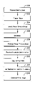
sea,
or in the body of water at a known depth, record the reflections, and the
resulting seismic data may be processed to evaluate the location and depth of
the subsurface reflectors. By measuring the time it takes for the reflections
(e.g.,
acoustic signal) to travel from the source to plural receivers, it is possible
to
estimate the depth and/or composition of the features causing such
reflections.
These features may be associated with subterranean hydrocarbon deposits.
[0003] For marine applications, seismic sources are essentially impulsive
(e.g., compressed air is suddenly allowed to expand) or vibratory. One of the
1
CA 02844159 2014-02-27
CG200070
most used impulsive sources is air guns, which produce a high amount of
acoustic energy over a short time. Such a source is towed by a vessel either
at
the water surface or at a certain depth. Acoustic waves from the air gun
propagate in all directions. A typical frequency range of the emitted acoustic
waves is between 2 and 300 Hz.
[0004] A vibratory source, which may include hydraulically- or
electrically-
powered sources and sources employing piezoelectric or magnetostrictive
material, is described in Patent Application Serial No. 13/415,216, (herein
'216)
"Source for Marine Seismic Acquisition and Method," filed on March 8, 2012,
the
entire content of which is incorporated herein by reference.
[0005] A characteristic of a seismic source, be it impulsive or
vibratory, is
its far-field signature. The far-field signature of the seismic source refers
to the
shape of the signal it generates. The signature of the seismic source changes
as
seismic waves propagate away from it. If a given direction is considered, the
signature varies with the distance from the seismic source along that
direction.
However, at some given distance, the signature achieves a stable shape, i.e.,
a
shape unlikely to change further as the waves continue to propagate. In other
words, beyond this given distance, the signature remains the same. Note that
the amplitude decreases inversely proportional to the distance even past this
given distance. The region where the signature shape does not change
significantly with distance is the far-field domain of the seismic source, and
its
signature in this domain is called the far-field signature.
[0006] More specifically, when the seismic source is shot, it produces a
complex output pressure pulse in the water. If this pressure pulse is
converted to
an electrical signal, for example, by using a near-field hydrophone, the
electrical
signal may include a short wavetrain whose envelope displays an initial fast
rise
followed by several rapidly-decaying oscillations. An envelope of the
wavetrain
2
CA 02844159 2014-02-27
CG200070
may be, for example, about 800 ms long, and this envelop may be the "far-field
signature" of the source.
[0007]
Determining the far-field signature is desirable, for example,
because, traditionally, an estimate of the far-field signature is used to
deconvolve
the recorded seismic data to minimize interference and/or to obtain zero-phase
wavelets. This process is known as de-signature. There are other reasons for
obtaining the far-field signature as will be recognized by those skilled in
the art.
[0008] Thus,
various methods are used to determine the far-field
signature. For
example, European Patent Application EP0047100B1,
"Improvements in/or relating to determination of far-field signatures, for
instance
of seismic sources," the entire content of which is incorporated herein by
reference, presents a method applicable to air guns for determining the far-
field
signature generated by an array of several units. Each unit is provided with
its
"near-field hydrophone" located known distance from the source. The method
sequentially fires all units (i.e., when one unit is fired, the other units
are not
fired) located in the array, which implies that interactions between units are
neglected. By knowing some environmental parameters (reflection at sea/air
interface, source depth, etc.), the far-field signature can be estimated by
summation of the individual source unit's signatures as detected by each near-
field hydrophone and by taking into account (synthetically) the ghost effect.
[0009] U.S.
Patent No. 4,868,794, "Method of accumulation data for use in
determining the signatures of arrays of marine seismic sources," presents a
similar method as discussed above. However, this method provides the far-field
signature of an array when all units are fired synchronously, which implies
that
the interactions between sources are taken into account. Each seismic unit can
be represented by a notional near-field signature given by post-processed near-
field data. The far-field signature array estimate can then be determined at
any
desired point below the sea surface, and not only along the vertical axis
generally
3
CA 02844159 2014-02-27
CG200070
used for direct far-field measurement. However, there is a problem with this
method: When a near-field sensor is used to determine the sound pressure of a
given source unit, that near-field sensor also detects sound pressures from
other
source units and their interactions. Thus, a processing step (for determining
the
notional near-field signature) is necessary to separate the sound pressures
from
the other source units and to remove these components. Because this
processing step is time-consuming and may introduce inaccuracies, not having
to
perform this step is desirable.
[0010] Another technique described in GB 2,468,912, "Processing seismic
data," the entire content of which is included herein by reference, presents a
method for providing quantitative error in far-field signature estimation by
using
both the method described above (based on notional near-field signature) and
data measured at specific receiver points along streamers. These data are
compared and can show if any errors notional signatures estimation can lead to
errors in far-field signature estimation.
[0011] However, it is difficult, if not impossible, to measure the far-
field
signature of a source in a direct way as noted in the above paragraphs. For
example, the water depth may be insufficient to prevent the measurements from
being substantially affected by sea-bottom reflections. Other practical
obstacles
are known that distort true far-field measurements. Thus, a far-field
signature
may be estimated according to a model of the far-field signature based on
measured physical parameters.
[0012] Further, the methods discussed above suffer from one or more
disadvantages. For example, if the near-field sensor is used to record the
near-
field signature, the measurement may not be accurate or the sensor may fail.
If a
far-field sensor is used (which should be located at a minimum depth, which
varies in the seismic community; however, an example is at least 300 m below
the source), the equipment for such measurements is expensive and not always
4
CA 02844159 2014-02-27
CG200070
reliable. Methods that do not rely on a sensor but use various models to
calculate the far-field signature are not accurate and require intensive and
time-
consuming processing steps. Also, they may not be applicable for shallow water
applications.
[0013] Thus, it is desired to obtain the far-field signature of a marine
source with no or minimum additional equipment, in a reliable way, based on
real, rather than estimated, data to overcome the afore-described problems and
drawbacks.
SUMMARY
[0014] According to an embodiment, there is a method for calculating an
estimate far-field signature (FF) of a seismic source. The method includes
receiving seismic data collected with seismic sensors having a variable-depth
distribution so that ghost diversity is present; stacking the seismic data at
the sea
floor; calculating in a processor the estimate far-field signature (FF) based
on a
ghost period (0 and a relative amplitude (yi) of two traces from the seismic
data;
and generating a final image of sub-surface based on the estimate far-field
signature (FF).
[0015] According to another embodiment, there is a method for calculating
an estimate far-field signature (FF) of a seismic source. The method includes
receiving seismic data collected with seismic sensors having a variable-depth
distribution so that ghost diversity is present; stacking the seismic data at
the sea
floor; calculating in a processor the estimate far-field signature (FF) based
on a
ghost period (t1) and a relative amplitude (yi) of two traces from the seismic
data,
wherein the estimate far-field signature (FF) is given by FF(f)= IITI(f).Gt(f)
EilGi(f)12
wherein T, is a ghosted estimate far-field signature, G, a corresponding
ghost,
CA 02844159 2014-02-27
CG200070
and "i" is an index for a given trace; and generating a final image of sub-
surface
based on the estimate far-field signature (PP).
[0016] According to yet another embodiment, there is a method for
calculating an estimate far-field signature (PP) of a seismic source. The
method
includes receiving seismic data collected with seismic sensors having a
variable-
depth distribution so that ghost diversity is present; stacking the seismic
data at
the sea floor; calculating in a processor the estimate far-field signature
(FF)
based on a ghost period (t1) and a relative amplitude (yi) of two traces from
the
seismic data, wherein the estimate far-field signature (FF') is given by FF(f)
=
Ei Ti(f).Gg
EilGiV)12), wherein Ti is a ghosted estimate far-field signature, G, a
corresponding ghost, and "i" is an index for a given trace; deghosting the
estimate far-field signature (PP) to obtained a deghosted far-field signature
(F);
and generating a final image of sub-surface based on the deghosted far-field
signature (F).
[0017] The above paragraphs in the Summary section present a simplified
summary of the embodiments discussed later with the purpose of offering a
basic
understanding of some novel aspects to the reader. However, this section is
not
intended to be exhaustive or to provide critical features of the invention.
BRIEF DESCRIPTION OF THE DRAWINGS
[0018] The accompanying drawings, which are incorporated in and
constitute a part of the specification, illustrate one or more embodiments
and,
together with the description, explain these embodiments. In the drawings:
[0019] Figure 1 is a schematic diagram of a seismic survey system that
uses a far-field sensor for determining a far-field signature of a seismic
source;
6
CA 02844159 2014-02-27
CG200070
[0020] Figure 2 is a flowchart of a method for calculating a far-field
signature of a seismic source;
[0021] Figure 3 is a graph illustrating input data for calculating a far-
field
signature;
[0022] Figure 4 is a graph illustrating sea-floor stack, ghosted estimate
far-
field signature, and a difference therebetween;
[0023] Figure 5 is a flowchart of a processing method for generating a
final
image of a surveyed subsurface;
[0024] Figure 6 is a schematic diagram illustrating a multi-component
seismic source;
[0025] Figure 7 is a schematic diagram of a variable-depth streamer; and
[0026] Figure 8 is a schematic diagram of a computing device that
implements one or more methods discussed herein.
[0027] These drawings illustrate specific embodiments described herein
and are not intended to limit the invention to these particular embodiments.
Those skilled in the art would recognize that the invention is susceptible to
various modifications or alternative forms.
DETAILED DESCRIPTION
[0028] The following description of the exemplary embodiments refers to
the
accompanying drawings. The same reference numbers in different drawings
identify the same or similar elements. The following detailed description does
not
limit the invention. Instead, the scope of the invention is defined by the
appended
claims. The following embodiments are discussed, for simplicity, with regard
to
marine seismic data acquired with a variable-depth streamer. However, the
7
CA 02844159 2014-02-27
CG200070
embodiments to be discussed next are not limited to this type of data
acquisition,
but may be applied to other seismic acquisition systems, for example, those
using
underwater vehicles or ocean bottom nodes located at different depths.
[0029] Reference throughout the specification to "one embodiment" or "an
embodiment" means that a particular feature, structure or characteristic
described
in connection with an embodiment is included in at least one embodiment of the
subject matter disclosed. Thus, the appearance of the phrases "in one
embodiment" or "in an embodiment" in various places throughout the
specification
is not necessarily referring to the same embodiment. Further, the particular
features, structures or characteristics may be combined in any suitable manner
in
one or more embodiments.
[0030] According to an exemplary embodiment, there is a method for
calculating a far-field signature of a marine source based on seismic data
acquired at different depths relative to the water surface.
[0031] Before discussing the method for calculating the far-field
signature
of a seismic source, a seismic survey system 100 is discussed with reference
to
Figure 1. System 100 includes a vessel 102 that tows plural streamers 110
(only
one is shown in the figure for simplicity) and a seismic source 130. Streamer
110
is attached through a lead-in cable (or other cables) 112 to vessel 102, while
source 130 is attached through an umbilical 132 to the vessel. A head float
114,
which floats at the water surface 104, is connected through a cable 116 to a
head
110A of streamer 110, while a tail buoy 118 is connected through a similar
cable
116 to a tail 110B of streamer 110. Head float 114 and tail buoy 118 maintain
a
depth of the streamer and are also provided with GPS (Global Positioning
System) or other communication equipment 120 for determining a position of the
streamer.
8
,
CA 02844159 2014-02-27
CG200070
[0032] In this regard, it is known that an exact position of each sensor
122
(only a couple of them are illustrated in Figure 1 for simplicity) is
important to be
known when processing the seismic data recorded by these sensors. Thus,
vessel 102 is also provided with GPS 124 and a controller 126 that collects
the
position data associated with the head and tail of the streamer and also the
position of the vessel and calculates, based on the known geometry of the
streamer, the absolute position of each sensor.
[0033] The same happens for source 130. A GPS system 134 is located
on float 137 for determining the position of the source elements 136. Source
elements 136 are connected to float 137 to travel at desired depths below the
water surface 104. During operation, vessel 102 follows a predetermined path T
while source elements (usually air guns) 136 emit seismic waves 140. These
waves bounce off the ocean bottom 142 and other layer interfaces below the
ocean bottom 142 and propagate as reflected/refracted waves 144 that are
recorded (as primaries) by sensors 122. However, each primary has an
associated ghost 146c, which corresponds to another wave 146a generated by
source 130, reflected as wave 146b from the ocean bottom 142, and then further
reflected from the water surface 104. The positions of both the source element
136 and recording sensor 122 are determined with the GPS systems 120 and
134 and recorded together with the seismic data in a storage device 127
onboard
the vessel.
[0034] However, having a GPS system at the two ends of a 10 km long
streamer does not produce accurate results for the sensors 122 located far
from
both ends. Thus, in an effort to improve the accurate location of the sensors,
modern seismic survey systems use acoustic transceivers 128 distributed along
the streamer at known locations, and these transceivers interrogate adjacent
transceivers, located on the neighboring streamers, for detecting the relative
positions of each receiver along all streamers. Combined with the traditional
9
CA 02844159 2014-02-27
CG200070
GPS, such a system is capable of providing more accurate positioning of the
sensors.
[0035] With this background, a method for calculating a far-field
signature
for a seismic source, be it impulsive, vibratory or of another nature, is now
discussed. The method relies on seismic data acquired with seismic sensors
located at different depths. An example of seismic sensors located along a
streamer was provided with regard to Figure 1. Note that streamer 110 may be a
variable-depth streamer as will be discussed later. However, it is also
possible
that underwater vehicles equipped with appropriate seismic sensors acquire the
seismic data. Alternatively, it is possible to have ocean bottom nodes, i.e.,
sensors located on the ocean bottom, that follow a variable-depth ocean bottom
to acquire the seismic data.
[0036] A common feature of seismic data acquired at different depths is
the diversity of the receiver ghosts, i.e., the fact that different parts of
the seismic
data are recorded at different depths. Because of the different depths and
because the ghost is reflected from the water surface, the recorded ghosts
have
different travel times, and are thus diverse. As long as this diversity is
achieved,
it is irrelevant whether the seismic data was collected using depth-varying
streamers, ocean bottom nodes, underwater vehicles or any other method.
[0037] With this diverse seismic data, one goal of the method is to
extract
an estimate of the far-field signature. This may be achieved as now discussed
with regard to Figure 2. Figure 2 is a flowchart of the method for calculating
the
far-field signature of a seismic source. Note that a seismic source may
include
one or more source elements, i.e., an air gun, a vibratory element, a
combination
of them, etc. In step 200, seismic data is received at a processing device,
which
will be discussed later. The seismic data exhibits receiver ghost diversity
because the seismic sensors' depths (hydrophone, particle motion sensor, or
any
appropriate seismic sensors or combinations thereof) vary with the offset as
CA 02844159 2014-02-27
CG200070
already discussed. In step 202, the seismic data is flattened and then stacked
at
the sea floor. This step involves picking first arrivals and then the picks
are
aligned at the same time. Given that the selected data covers in general the
full
area of the survey, the geological diversity is sufficient to remove any
imprints by
events.
[0038] Figure 3 illustrates the seismic data after being flattened to the
sea
floor, and this data corresponds to various channels associated with a
streamer.
For example, the upper part of the graph shows various channels, e.g., channel
6
corresponds to reference number 300, and the lower part of the graph
illustrates
corresponding traces 302. A channel represents the seismic data collected from
a given number of seismic sensors (three for example for a Sercel streamer).
Each channel includes seismic data collected from a different depth because a
depth of the seismic sensors along the streamer changes. This property
provides the needed diversity for calculating the far-field signature.
[0039] The data corresponding to a single channel may be written as:
chicpp = FF * Gi * - G
eol(CDP), (1)
wherein "i" is the channel number, CDP is the common depth point, FF is the
actual far-field signature, Gi is the "i" receiver ghost, and Geoi is the
actual
reflected wavefield by the geology below the sea bed. If the data from each
channel is summed for all the CDP (i.e., the data is stacked), it yields a
ghosted
estimate far-field Ti(f), which is given by:
T21 ECDP ChiCDP = FF * Gi, (2)
where the sum is performed for all the CDP points, i.e., n measurements.
[0040] In the following, it is considered that seismic data has been
recorded using hydrophones. However, the same method may be applied if
11
CA 02844159 2014-02-27
CG200070
using another type of seismic sensor provided that ghost G(f) is changed
accordingly. Assuming the hydrophone sensitivities have been corrected, and
the ghost travel-times t have been identified as indicated in step 204, the
following equations hold for the estimated far-field signature FF:
Ti(f) = G1(f) = FF(f), (3)
G(f) = 1 - e2infti, and (4)
FF(f) .EiTi(n'Gi(i) (5)
ELIGi(f)12
where FF is the true (actual) far-field signature, f is the frequency, j is
the
imaginary number, and equation (5) describes in the numerator a multiplication
in
the frequency domain between the ghosted estimate far-field T, and the
corresponding receiver ghost G,, and the denominator includes the auto-
correlation of the receiver ghost G. Note that receiver ghost G, depends on
ghost travel-time t, which depends on the depth of the seismic sensor. Thus,
equation (4) encompasses the ghost diversity.
[0041]
Setting up in step 206 the mathematical model described by
equations (3)-(5), and considering that applying a receiver ghost Gj to t and
vice
versa should generate an identical result, providing the ghost parameters are
correctly chosen, the ghost travel-time t, can be calculated in step 208 as
follows.
For example, consider two ghosted estimate far-field signatures T, and Tj
aligned
on their first arrival. The two ghosted estimate far-field signatures are
given by:
XI(t) = Ti(t) + rTi(t - ti), and (6)
)0(0 = T)(t) + rT.(t - ti), (7)
J
12
CA 02844159 2014-02-27
CG200070
where X is the cross-ghosted far-field, i.e., applying the ghost operator of
trace
"I" to trace "j." A difference between equations (6) and (7) is equal to
difference
function :
E = X (t) ¨ X I (t) = -E1(0. (8)
Note that difference function E depends on travel-time t, trace "i" and ghost
"j."
Later, the same difference function is summed over all travel-times or over
all
pairs of traces and ghosts.
[0042] Various algorithms may be applied to resolve equation (8) to find
out the ghost travel-time t. For example, a Newton scheme may be used to
solve non-linear equations. The Newton scheme may be applied to an error
function E which is defined later. The Newton scheme requires not only an
error
function E but also its gradient and hessian. The error function E may be
defined
as the sum over all pairs i and j and all travel-times for the difference
function E ,
i.e., E is given by:
= 2
E = iEt,i, (01 = (9)
[0043] To calculate the gradient and hessian (i.e., the first and second
order derivatives) of the error function E, it is necessary to know the
gradient for
the difference function e. The gradient of the difference function E is given
by
equations:
¨a El: (t) = rT (t ¨ t3, and (10)
ati
a El(t)
¨ = (t ¨ ti), (11)
at
[0044] Based on equations (10) and (11), the gradient of the error
function
E is calculated as being:
13
CA 02844159 2014-02-27
CG200070
aEa Ei.(t)
- =Et E = (t) and (12)
at, t at,
aE " = iõaEli(t)
¨ 2,t
at; - at,
[0045] The hessian of the error function is given by the following
equations:
a2 E jr )aet(t)
14
( )
atiat; - ati ati '
a2E ael(02
¨aq =Et¨ati ¨rd r(t ¨ ti), and (15)
a2E aE';(02
at2 Lit at= + rEi (t ti). (16)
[0046] Applying the Newton algorithm iteratively to equations (9) and
(12)-
(16), an estimate of ti is achieved. In order to converge to a true minimum,
at
each iteration, the data is high-cut filtered, with increasing maximum
frequency
as the algorithm progresses. This concludes step 208 illustrated in Figure 2.
[0047] Next, a relative amplitude determination is performed in step 210.
This step takes place when the receivers have different signatures or when the
seismic data used is not the same for all channels (e.g., due to editing; for
this
situation, it is possible to determine a channel-dependent gain). Assuming
that
to is a reference trace for amplitudes and yi is the gain that needs to be
applied to
trace ti to match to from an amplitude point of view, then, for any two traces
i and
j, the following equations hold:
EtlyiX1(t) ¨ (012, and (17)
(pi = Et xi (t) * xi(t), (18)
14
CA 02844159 2014-02-27
CG200070
where equation (17) reflects the difference E summed over all possible travel
times ti, while equation (18) reflects the correlation of trace "i" ghosted
with ghost
"j" and trace "j" ghosted with ghost "i." In addition, the following equations
also
hold:
("Yi)
= 0, and (19)
yi = 4= (20)
[0048] This system of equations may be solved, for example, by applying a
Choleski algorithm, which is a known matrix decomposition technique, and for
this reason no details are provided herein.
[0049] Next, the calculated far-field may be deghosted, in terms of the
source ghost, in step 212 in Figure 2. For this step, the travel-time from
source
to surface is considered to be 6 and -r is the surface reflectivity. The
impulsive
part of the non-ghosted far-field (note that a far-field signature may have an
impulsive part, a ghost part, the ghost part being later in time than the
impulsive
part and a bubble part which is even later in time than the impulsive part)
can be
iteratively found using a Newton algorithm and time-summing over the impulsive
part of the non-ghosted far-field based on the following equations:
E(t) = rFF(t) + FF(t + 6), (21)
E =-2-1 Et<47nsIE (012 and (22)
(AAor)- -H-1 = G (23)
where FF is the receiver deghosted far-field signature, G is the gradient and
H is
the hessian of E with S and r being the variables. The gradient G is given by:
CA 02844159 2014-02-27
CG200070
G FF'(t+ S)E(t)) and (24)
k Et FF(*(0
the hessian H is given by:
H = (Et F F'(t+a)2 + FF"(t + 8)E(t) Et FF(t)F + 8)). (25)
Et FF (t)FF' (t + Et F F (02
[0050] The
Newton algorithm may be applied to these equations starting
with an initial value of 1.0 for r and 5 being the FF picked minimum, for
example,
+s
8 may be given by 2S0s+ where
S.., So and S+ are three points closest to the
2 -S+ -S_ _
minimum.
[0051] The
source deghosted far-field signature Fo(t) can be expressed as
the convolution of FF with the inverse of the source ghost (which is related
to the
reflectivity r):
F0(t) = Er_o ri * FF(t ¨ (26)
This operation is imperfect although it gives the right result at the earliest
times,
i.e., during the impulsive part of the FF. Once the impulsive part has been
isolated, it can be ghosted again and remove from the FF, thus, leaving the
bubble, which can then be spectrally deconvolved.
[0052] Having
found the deghosted far-field signature, it is now possible to
apply various processing algorithms (to be discussed later) in step 214 for
generating a final image in step 216 of the surveyed subsurface.
[0053]
Results of the various steps illustrated in Figure 2 and discussed
above are illustrated in Figure 4, which shows the estimated far-field
signature
400, the sea-floor stack 402, the ghosted estimated far-field FF 404, and the
difference 406 between the sea-floor stack 402 and the ghosted estimated far-
field 404. Note that the X axis of the figure shows the number of channels
(see
16
CA 02844159 2014-02-27
CG200070
also Figure 3), while the Y axis of the figure shows the time. The first group
of
traces corresponds to channel 1, the second group of traces correspond to
channel 6, and so on, with a depth of the seismic receivers increasing with
the
number of channels.
[0054] Seismic data processed for estimating a far-field signature and/or
deghosted far-field signature may be processed in a corresponding processing
device for generating a final image of the surveyed subsurface. For example,
the
seismic data may be received in step 500 of Figure 5 at the processing device.
In step 502 pre-processing methods are applied, e.g., demultiple, signature
deconvolution, trace summing, vibroseis correlation, resampling, etc. In step
504
the main processing takes place, e.g., deconvolution, amplitude analysis,
statics
determination, common middle point gathering, velocity analysis, normal move-
out correction, muting, trace equalization, stacking, noise rejection,
amplitude
equalization, etc. In step 506 final or post-processing methods are applied,
e.g.
migration, wavelet processing, inversion, etc. In step 508 the final image of
the
subsurface is generated. Note that the method discussed with regard to Figure
2
for determining the far-field signature and/or deghosted far-field signature
may be
part of any of steps 502, 504 and 506.
[0055] The seismic data received in step 200 in Figure 2 or in step 500
in
Figure 5 may be generated with a source array having a horizontal distribution
or
with a multi-level source array. A source array includes plural source
elements.
A source element may be impulsive, e.g., an air gun. A multi-level source 600
is
illustrated in Figure 6 as having one or more sub-arrays. The first sub-array
602
has a float 606 configured to float at the water surface 608 or underwater at
a
predetermined depth. Plural source elements 610a-d are suspended from float
606 in a known manner. A first source element 610a may be suspended closest
to head 606a of float 606, at a first depth z1. A second source element 610b
may be suspended next, at a second depth z2, different from z1. A third source
17
CA 02844159 2014-02-27
CG200070
element 610c may be suspended next, at a third depth z3, different from z1 and
z2, and so on. Figure 6 shows, for simplicity, only four source elements 610a-
d,
but an actual implementation may have any desired number of source points. In
one application, because the source elements are distributed at different
depths,
the source elements at the different depths are not simultaneously activated.
In
other words, the source array is synchronized, i.e., a deeper source element
is
activated later in time (e.g., 2 ms for 3 m depth difference when the speed of
sound in water is 1,500 m/s) such that corresponding sound signals produced by
the plural source elements coalesce, and thus, the overall sound signal
produced
by the source array appears to be a single sound signal. In one embodiment,
the
high-frequency source elements are simultaneously activated in a flip-flop
mode
with the source elements of the low-frequency source elements. In another
embodiment, all the source elements are simultaneously activated with
incoherent, coded signals so the recorded seismic signals can be separated
based on the source element that emitted that signal.
[0056] The
depths z1 to z4 of the source elements of the first sub-array
602 may obey various relationships. In one application, the depths of the
source
elements increase from the head toward the tail of the float, i.e.,
z1<z2<z3<z4.
In another application, the depths of the source elements decrease from the
head
to the tail of the float. In another application, the source elements are
slanted,
i.e., on an imaginary line 614. In still another application, line 614 is
straight. In
yet another application, line 614 is curved, e.g., part of a parabola, circle,
hyperbola, etc. In one application, the depth of the first source element for
the
sub-array 1002 is about 5 m and the largest depth of the last source element
is
about 8 m. In a variation of this embodiment, the depth range is between 8.5
and
10.5 m or between 11 and 14 m. In another variation of this embodiment, when
line 614 is straight, the depths of the source elements increase by 0.5 m from
one source element to an adjacent source element. Those skilled in the art
would recognize that these ranges are exemplary and these numbers may vary
18
CA 02844159 2014-02-27
CG200070
from survey to survey. A common feature of all these embodiments is that the
source elements have variable depths so that a single sub-array exhibits
multiple-level source elements.
[0057] The above embodiments were discussed without specifying what
type of seismic receivers is used to record the seismic data. In this sense,
it is
known in the art to use, for a marine seismic survey, streamers towed by one
or
more vessels, and the streamers include the seismic receivers. The streamers
may be horizontal or slanted or have a curved profile as illustrated in Figure
7.
[0058] The curved streamer 700 of Figure 7 includes a body 702 having a
predetermined length, plural detectors 704 provided along the body, and plural
birds 706 provided along the body for maintaining the selected curved profile.
The streamer is configured to flow underwater when towed such that the plural
detectors are distributed along the curved profile. The curved profile may be
described by a parameterized curve, e.g., a curve described by (i) a depth zo
of a
first detector (measured from the water surface 712), (ii) a slope so of a
first
portion T of the body with an axis 714 parallel with the water surface 712,
and (iii)
a predetermined horizontal distance hc between the first detector and an end
of
the curved profile. Note that not the entire streamer has to have the curved
profile. In other words, the curved profile should not be construed to always
apply to the entire length of the streamer. While this situation is possible,
the
curved profile may be applied only to a portion 708 of the streamer. In other
words, the streamer may have (i) only a portion 708 having the curved profile
or
(ii) a portion 708 having the curved profile and a portion 710 having a flat
profile,
with the two portions attached to each other.
[0059] An example of a representative processing device capable of
carrying out operations in accordance with the embodiments discussed above is
illustrated in Figure 8. Hardware, firmware, software or a combination thereof
may be used to perform the various steps and operations described herein. The
19
CA 02844159 2014-02-27
CG200070
processing device 800 of Figure 8 is an exemplary computing structure that may
be used in connection with such a system, and it may implement any of the
processes and methods discussed above or combinations of them.
[0060] The exemplary processing device 800 suitable for performing the
activities described in the exemplary embodiments may include server 801.
Such a server 801 may include a central processor unit (CPU) 802 coupled to a
random access memory (RAM) 804 and to a read-only memory (ROM) 806. The
ROM 806 may also be other types of storage media to store programs, such as
programmable ROM (PROM), erasable PROM (EPROM), etc. Processor 802
may communicate with other internal and external components through
input/output (I/O) circuitry 808 and bussing 810 to provide control signals
and the
like. For example, processor 802 may communicate with the sensors, electro-
magnetic actuator system and/or the pressure mechanism of each source
element. Processor 802 carries out a variety of functions as are known in the
art,
as dictated by software and/or firmware instructions.
[0061] Server 801 may also include one or more data storage devices,
including disk drives 812, CD-ROM drives 814, and other hardware capable of
reading and/or storing information, such as a DVD, etc. In one embodiment,
software for carrying out the above-discussed steps may be stored and
distributed on a CD-ROM 816, removable media 818 or other form of media
capable of storing information. The storage media may be inserted into, and
read by, devices such as the CD-ROM drive 814, disk drive 812, etc. Server 801
may be coupled to a display 820, which may be any type of known display or
presentation screen, such as LCD, plasma displays, cathode ray tubes (CRT),
etc. A user input interface 822 is provided, including one or more user
interface
mechanisms such as a mouse, keyboard, microphone, touch pad, touch screen,
voice-recognition system, etc.
CA 02844159 2014-02-27
CG200070
[0062] Server 801 may be coupled to other computing devices, such as
the equipment of a vessel, via a network. The server may be part of a larger
network configuration as in a global area network (CAN) such as the Internet
828, which allows ultimate connection to the various landline and/or mobile
client/watcher devices.
[0063] As also will be appreciated by one skilled in the art, the
exemplary
embodiments may be embodied in a wireless communication device, a
telecommunication network, as a method or in a computer program product.
Accordingly, the exemplary embodiments may take the form of an entirely
hardware embodiment or an embodiment combining hardware and software
aspects. Further, the exemplary embodiments may take the form of a computer
program product stored on a computer-readable storage medium having
computer-readable instructions embodied in the medium. Any suitable computer-
readable medium may be utilized, including hard disks, CD-ROMs, digital
versatile discs (DVD), optical storage devices or magnetic storage devices
such
a floppy disk or magnetic tape. Other non-limiting examples of computer-
readable media include flash-type memories or other known types of memories.
[0064] The disclosed exemplary embodiments provide a method and a
computing device for calculating a far-field signature and/or deghosted far-
field
signature for a seismic source. It should be understood that this description
is
not intended to limit the invention. On the contrary, the exemplary
embodiments
are intended to cover alternatives, modifications and equivalents, which are
included in the spirit and scope of the invention as defined by the appended
claims. Further, in the detailed description of the exemplary embodiments,
numerous specific details are set forth in order to provide a comprehensive
understanding of the claimed invention. However, one skilled in the art would
understand that various embodiments may be practiced without such specific
details.
21
CA 02844159 2014-02-27
CG200070
[0065] Although the features and elements of the present exemplary
embodiments are described in the embodiments in particular combinations, each
feature or element can be used alone without the other features and elements
of
the embodiments or in various combinations with or without other features and
elements disclosed herein.
[0066] This written description uses examples of the subject matter
disclosed to enable any person skilled in the art to practice the same,
including
making and using any devices or systems and performing any incorporated
methods. The patentable scope of the subject matter is defined by the claims,
and
may include other examples that occur to those skilled in the art. Such other
examples are intended to be within the scope of the claims.
22