Some of the information on this Web page has been provided by external sources. The Government of Canada is not responsible for the accuracy, reliability or currency of the information supplied by external sources. Users wishing to rely upon this information should consult directly with the source of the information. Content provided by external sources is not subject to official languages, privacy and accessibility requirements.
Any discrepancies in the text and image of the Claims and Abstract are due to differing posting times. Text of the Claims and Abstract are posted:
| (12) Patent Application: | (11) CA 2860278 |
|---|---|
| (54) English Title: | REAL-TIME FISHING CONDITIONS OPTIMIZATION SOFTWARE AND INFORMATION MAPPING, MANAGEMENT AND VISUALIZATION SYSTEM |
| (54) French Title: | LOGICIEL D'OPTIMISATION DE CONDITIONS DE PECHE EN TEMPS REEL ET SYSTEME DE CARTOGRAPHIE, GESTION ET VISUALISATION D'INFORMATION |
| Status: | Deemed Abandoned and Beyond the Period of Reinstatement - Pending Response to Notice of Disregarded Communication |
| (51) International Patent Classification (IPC): |
|
|---|---|
| (72) Inventors : |
|
| (73) Owners : |
|
| (71) Applicants : |
|
| (74) Agent: | |
| (74) Associate agent: | |
| (45) Issued: | |
| (22) Filed Date: | 2014-08-21 |
| (41) Open to Public Inspection: | 2016-02-21 |
| Availability of licence: | N/A |
| Dedicated to the Public: | N/A |
| (25) Language of filing: | English |
| Patent Cooperation Treaty (PCT): | No |
|---|
| (30) Application Priority Data: | None |
|---|
RTFISH is an integrated field (app) and online software (computer) solution
designed to alert and help fisherman determine the optimal times and
locations where to fish, for a specific species of fish. RTFISH mathematically
analyzes real-time and historical water and weather data and compares
physical and species-specific biological preferences to calculate the
probabilities of a stream, river, lake, reservoir or any monitored body of
water, meeting the ideal fishing conditions for any given species of fish.
Traditionally, fisherman have relied on local contacts, or their own personal
knowledge of a body of water, to plan for a fishing trip that yields strong
numbers of hookups. With RTFISH, any fisher person now has the ability to
predict the probability of ideal fishing conditions and locations based on
scientific and mathematically-based calculations. This removes the guess-
work when predicting the best times and locations to fish based on fishing
conditions and provides fisher people with the knowledge to more effectively
plan their next fishing trip and prepare themselves with the right baits and
fishing techniques necessary to improve their fish catch/hook-up ratio.
RTFISH also provides the platform for social sharing of fishing photos and
associated meta data for future use and based on user-preferences defined
by the user.
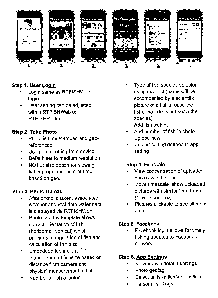
RTFISH combines multiple visuals into a single graphical user interface,
complete with real-time water condition graphs, fish success prediction
charts,
location maps, optimized tackle selections and real-time social media feeds.
RTFISH is an integrated field (app) and online software (computer) solution
designed to alert and help fisherman determine the optimal times and
locations where to fish, for a specific species of fish. RTFISH mathematically
analyzes real-time and historical water and weather data and compares
physical and species-specific biological preferences to calculate the
probabilities of a stream, river, lake, reservoir or any monitored body of
water, meeting the ideal fishing conditions for any given species of fish.
Traditionally, fisherman have relied on local contacts, or their own personal
knowledge of a body of water, to plan for a fishing trip that yields strong
numbers of hookups. With RTFISH, any fisher person now has the ability to
predict the probability of ideal fishing conditions and locations based on
scientific and mathematically-based calculations This removes the guess-
work when predicting the best times and locations to fish based on fishing
conditions and provides fisher people with the knowledge to more effectively
plan their next fishing trip and prepare themselves with the right baits and
fishing techniques necessary to improve their fish catch/hook-up ratio.
RTFISH also provides the platform for social sharing of fishing photos and
associated meta data for future use and based on user-preferences defined
by the user.
RTFISH combines multiple visuals into a single graphical user interface,
complete with real-time water condition graphs, fish success prediction
charts,
location maps, optimized tackle selections and real-time social media feeds.
Note: Claims are shown in the official language in which they were submitted.
Sorry, the claims for patent document number 2860278 were not found.
Text is not available for all patent documents. The current dates of coverage are on the
Currency of Information
page
Note: Descriptions are shown in the official language in which they were submitted.
2024-08-01:As part of the Next Generation Patents (NGP) transition, the Canadian Patents Database (CPD) now contains a more detailed Event History, which replicates the Event Log of our new back-office solution.
Please note that "Inactive:" events refers to events no longer in use in our new back-office solution.
For a clearer understanding of the status of the application/patent presented on this page, the site Disclaimer , as well as the definitions for Patent , Event History , Maintenance Fee and Payment History should be consulted.
| Description | Date |
|---|---|
| Inactive: Dead - Application incomplete | 2017-03-15 |
| Application Not Reinstated by Deadline | 2017-03-15 |
| Deemed Abandoned - Failure to Respond to Maintenance Fee Notice | 2016-08-22 |
| Deemed Abandoned - Failure to Respond to Notice Requiring a Translation | 2016-03-15 |
| Inactive: Cover page published | 2016-03-01 |
| Application Published (Open to Public Inspection) | 2016-02-21 |
| Inactive: Incomplete | 2015-12-15 |
| Inactive: Request under s.37 Rules - Non-PCT | 2015-08-21 |
| Inactive: Reply to s.37 Rules - Non-PCT | 2014-11-05 |
| Inactive: Filing certificate - No RFE (bilingual) | 2014-10-10 |
| Inactive: IPC assigned | 2014-09-21 |
| Inactive: First IPC assigned | 2014-09-21 |
| Reinstatement Requirements Deemed Compliant for All Abandonment Reasons | 2014-08-28 |
| Inactive: Applicant deleted | 2014-08-28 |
| Correct Applicant Requirements Determined Compliant | 2014-08-28 |
| Inactive: Request under s.37 Rules - Non-PCT | 2014-08-27 |
| Application Received - Regular National | 2014-08-26 |
| Inactive: QC images - Scanning | 2014-08-21 |
| Small Entity Declaration Determined Compliant | 2014-08-21 |
| Inactive: Pre-classification | 2014-08-21 |
| Abandonment Date | Reason | Reinstatement Date |
|---|---|---|
| 2016-08-22 | ||
| 2016-03-15 |
| Fee Type | Anniversary Year | Due Date | Paid Date |
|---|---|---|---|
| Application fee - small | 2014-08-21 |
Note: Records showing the ownership history in alphabetical order.
| Current Owners on Record |
|---|
| MARTIN D. DRAEGER |
| Past Owners on Record |
|---|
| None |

