Note: Descriptions are shown in the official language in which they were submitted.
CA 02862762 2014-07-25
290405-7
METHOD AND APPARATUS FOR DETECTION OF
FOREIGN OBJECT DEBRIS
TECHNICAL FIELD
The invention relates to vision systems for the automated inspection of
transportation infrastructures and more particularly, to the detection of
objects using 3D laser
sensors.
BACKGROUND OF THE ART
The term Foreign Object Debris, or FOD, is generally used to describe the
loose
bits and pieces that can be found on airport operating surfaces. It can also
refer to any debris
or article alien to an infrastructure which would potentially cause damage or
degrade the
required safety or performance characteristics of the infrastructure. Although
typically useful
in the context of the aviation industry, the detection of objects which are
alien to a surface can
be useful for other transportation infrastructures such as railways, roads,
etc.
The Federal Aviation Administration (FAA) Advisory Circular (AC) 150/5220-24
indicates that "FOD can be generated from personnel, airport infrastructure
(pavements,
lights, and signs), the environment (wildlife, snow, ice) and the equipment
operating on the
airfield (aircraft, airport operations vehicles, maintenance equipment,
fueling trucks, other
aircraft servicing equipment, and construction equipment)". Furthermore the AC
notes that
"FOD can be composed of any material and can be of any color and size".
Moreover, the
Master's thesis of S. Graves entitled "Electro-Optical Sensor Evaluation of
Airfield
Pavement" indicates that "of these sources of FOD, pavement debris is one of
the most
prevalent". Raveling, the wearing away of the pavement surface caused by the
dislodging of
aggregate particles and loss of asphalt binder, ultimately leads to a very
rough and pitted
surface with FOD.
Most of the time, debris are harmless. In some cases, they cause minor damage
such as flat tires or nicked engine blades. In rare cases, they cause
catastrophic failures. The
crash of the Concorde in July 2000 was caused by FOD on the runway. FOD costs
airlines
- 1 -
CA 02862762 2014-07-25
290405-7
large expenses in aircraft repairs, flight delays, plane changes and fuel
inefficiencies.
Furthermore, there are other costs that cannot be calculated like the loss of
life and the
suspicion of malpractice.
Traditional approaches to FOD detection involve the use of manual driving
surveys wherein a single inspector, or a team of inspectors, drives an
inspection vehicle down
the center of the runway at speeds typically ranging from 80-100 km/h and
visually scans the
surface for FOD. However, research has shown that this approach misses upwards
of 96% of
FOD actually present on the runway.
Following the Concorde crash, automated scanning systems capable of detecting
debris emerged. Patents US 8,022,841, US 7,782,251, US 7,982,661, US 7,592,943
and patent
application publications US 2009/0243881, US 2011/0063445 and WO 2006/109074
disclose
several electro-optical and radar FOD detection systems. These systems seem
capable of
detecting FOD with a detection threshold of a few centimeters depending on the
weather,
lighting conditions, material, color, size and cross-section that the debris
present to the
detectors. It is acceptable for most FOD systems to emphasize detection of the
larger debris as
those pose a more significant safety risk. Nevertheless, data taken in an
operational context
shows that few FOD smaller than 1 cm are found on runways by current scanning
methods.
The Concorde was downed by FOD less than 5 mm in height.
Airports operating multiple crossing runways and taxiways may not be able to
build permanent installations along each runway and may have minimal space in
the safety
areas adjacent to runways.
None of the currently available solutions are able to provide the required
sensitivity to locate smaller debris and cover the entire infrastructure
operational area
(runways, taxiways and aprons) efficiently.
SUMMARY
According to one broad aspect of the present invention, there is provided a
method
for the detection of Foreign Object Debris (FOD) on a surface of a transport
infrastructure.
¨2¨
CA 02862762 2014-07-25
290405-7
The method comprises receiving 3D profiles of the surface from at least one 3D
laser sensor,
the 3D laser sensor including a camera and a laser line projector, the 3D
laser sensor being
adapted to be displaced to scan the surface of the transport infrastructure
and acquire 3D
profiles of the surface; analyzing the 3D profiles using a parametric surface
model to
determine a surface model of the surface; identifying pixels of the 3D
profiles located above
the surface using the surface model; generating a set of potential FOD by
applying a threshold
on the pixels located above the surface model to identify a set of at least
one protruding
object; providing detection information about the potential FOD.
In one embodiment, the method further comprises receiving known object data,
the known object data being information about a previously known object and
wherein the
generating the set of potential FOD further includes eliminating the known
object from the set
of protruding objects using the known object data.
In one embodiment, the method further comprises receiving geographical data
for
the 3D profiles and extracting a location for the protruding object using the
geographical data.
In one embodiment, the detection information includes the location.
In one embodiment, the method further comprises receiving known object data,
the known object data being information about a previously known object and
wherein the
generating the set of potential FOD further includes eliminating the known
object from the set
of protruding objects using the known object data, the location of the
protruding object and a
known location of the known object.
In one embodiment, the method further comprises extracting at least one of a
shape and a size of the protruding object from the 3D profiles.
In one embodiment, eliminating the known object includes using the shape
and/or
size of the protruding object.
¨3¨
CA 02862762 2014-07-25
290405-7
In one embodiment, the method further comprises assigning a severity level to
the
potential FOD using the shape and/or size, the detection information including
the severity
level.
In one embodiment, the method further comprises triggering an alarm upon
detection of the potential FOD, the alarm including an indication of the
severity level.
In one embodiment, the method further comprises generating a surface condition
assessment using the surface model and the 3D profiles, the surface condition
assessment
providing information about a surface condition of the surface.
In one embodiment, the threshold is determined based on at least one of size,
height and shape requirements for the detection.
In one embodiment, analyzing the 3D profiles using the parametric surface
model
to determine the surface model includes considering at least one surface
characteristic, the
surface characteristic including rutting, surface texture, joint, faulting
between concrete slabs,
crack, longitudinal profile, slope, cross-fall, lane marking and in-pavement
fixture.
In one embodiment, the method further comprises combining 3D profiles of each
of a plurality of 3D laser sensors for the steps of analyzing and identifying.
According to another broad aspect of the present invention, there is provided
a
system for the detection of Foreign Object Debris (FOD) on a surface of a
transport
infrastructure. The system comprises a processor adapted for receiving 3D
profiles of the
surface from at least one 3D laser sensor, the 3D laser sensor including a
camera and a laser
line projector, the 3D laser sensor being adapted to be displaced to scan the
surface of the
transport infrastructure and acquire 3D profiles of the surface; analyzing the
3D profiles using
a parametric surface model to determine a surface model of the surface;
identifying pixels of
the 3D profiles located above the surface using the surface model; generating
a set of potential
FOD by applying a threshold on the pixels located above the surface model to
identify a set of
at least one protruding object; and a FOD detection generator for providing
detection
information about the potential FOD.
-4-
CA 02862762 2014-07-25
290405-7
In one embodiment, the processor is further adapted for receiving known object
data, the known object data being information about a previously known object
and wherein
the processor is adapted for eliminating the known object from the set of
protruding objects
using the known object data for the generating the set of potential FOD.
In one embodiment, the processor is further adapted for receiving geographical
data for the 3D profiles and extracting a location for the protruding object
using the
geographical data.
In one embodiment, the processor is further adapted for receiving known object
data, the known object data being information about a previously known object
and wherein
the processor is adapted for eliminating the known object from the set of
protruding objects
using the known object data, the location of the protruding object and a known
location of the
known object for the generating the set of potential FOD.
In one embodiment, the detection information includes the location.
In one embodiment, the processor is adapted for extracting at least one of a
shape
and a size of the protruding object from the 3D profiles.
In one embodiment, eliminating the known object includes using the shape
and/or
size of the protruding object.
In one embodiment, the processor is further adapted for assigning a severity
level
to the potential FOD using the shape and/or size, the detection information
including the
severity level.
In one embodiment, the processor is further adapted for triggering an alarm
upon
detection of the potential FOD, the alarm including an indication of the
severity level.
In one embodiment, the processor is further adapted for generating a surface
condition assessment using the surface model and the 3D profiles, the surface
condition
assessment providing information about a surface condition of the surface.
-5-
CA 02862762 2014-07-25
290405-7
In one embodiment, the threshold is determined based on at least one of size,
height and shape requirements for the detection.
In one embodiment, analyzing the 3D profiles using the parametric surface
model
to determine the surface model includes considering at least one surface
characteristic, the
surface characteristic including rutting, surface texture, joint, faulting
between concrete slabs,
crack, longitudinal profile, slope, cross-fall, lane marking and in-pavement
fixture.
In one embodiment, the processor is further adapted for combining 3D profiles
of
each of a plurality of 3D laser sensors for the steps of analyzing and
identifying.
BRIEF DESCRIPTION OF THE DRAWINGS
Having thus generally described the nature of the invention, reference will
now be
made to the accompanying drawings, showing by way of illustration example
embodiments
thereof and in which:
FIG. 1 includes FIG. IA and FIG. 1B in which a vehicle provided with an
example Laser Foreign Object Debris (LFOD) detection system is shown from a
front
perspective view (FIG. 1A) and a rear perspective view (FIG. 1B) in operation;
FIG. 2 shows an example trajectory for an inspection vehicle to cover a
surface
with a width larger than the detection field-of-view of the 3D laser sensors;
FIG. 3 includes FIG. 3A and FIG. 3B which are screen shots of a graphical user
interface on which are shown a picture of the scene (FIG. 3A) and the results
of the detection
by the Laser Foreign Object Debris (LFOD) detection system (FIG. 3B);
FIG. 4 includes FIG. 4A, FIG. 4B and FIG. 4C which show a picture (FIG. 4A), a
3D image (FIG. 4B) and an image from a graphical user interface (FIG. 4C) on
which
detection results are shown for a set of keys planted on a surface to inspect;
¨6¨
CA 02862762 2014-07-25
290405-7
FIG. 5 includes FIG. 5A, FIG. 5B and FIG. 5C which show a picture (FIG. 5A), a
3D image (FIG. 5B) and an image from a graphical user interface (FIG. 5C) on
which
detection results are shown for a wrench planted on a surface to inspect;
FIG. 6 is a range image showing a variety of FOD;
FIG. 7 shows an example 3D laser sensor casing;
FIG. 8 includes FIG. 8A and FIG. 8B in which are shown range data (FIG. 8A)
and intensity data (FIG. 8B) obtained for a location on a surface to be
inspected;
FIG. 9 includes FIG. 9A, FIG. 9B and FIG. 9C which show example graphical
representations of the severity level : high severity (FIG. 9A), medium
severity (FIG. 9B) and
low severity (FIG. 9C);
FIG. 10 includes FIG. 10A, FIG. 10B and FIG. 10C which shows another example
of a severity rating assigned to each detected FOD, the picture is shown in
FIG. 10A, the
intensity image is shown in in FIG. 10B and the representation of the
detections on a graphical
user interface is shown in FIG. 10C;
FIG. 11 includes FIG. 11A and FIG. 11B which show two examples of aerial
maps overlapped with data about detected FOD wherein a FOD with a high
severity rating is
shown in FIG. 11A and a FOD with a low severity rating is shown in FIG. 11B;
FIG. 12 is a flow chart of example steps of the method for detection of FOD;
and
FIG. 13 is a block diagram of example components of the detection system.
It will be noted that throughout the appended drawings, like features are
identified
by like reference numerals.
DETAILED DESCRIPTION
A Laser Foreign Object Debris (LFOD) detection system for reliably detecting
objects that could degrade the required safety or performance characteristics
of infrastructures
¨7¨
CA 02862762 2014-07-25
290405-7
is described hereinafter. The infrastructure can be a road, railway, race
track, airport runway,
taxiway, apron, tunnel lining, or any other surface. These objects will be
referred to herein as
Foreign Object Debris, or FOD. The LFOD system can detect FOD as small as a
few
millimeters under a variety of lighting conditions (daytime and night-time,
surfaces lit by the
sun or covered in shadows). The LFOD system can also assess the pavement
condition in
order to identify areas where pavement debris could eventually originate by
detecting
raveling. It can be used on various pavement types ranging from dark asphalt
to concrete.
3D LASER SENSOR
The LFOD system for the detection of Foreign Object Debris (FOD) on a surface
of a transport infrastructure includes at least one 3D laser sensor to acquire
high-resolution 3D
profiles of the surface. Each 3D laser sensor has a camera and a laser line
projector.
Additional optical components, such as filters, are included as necessary. The
laser line is
projected onto the pavement surface and its image is captured by the camera.
The 3D laser sensors is adapted to be displaced to scan the surface of the
transport
infrastructure and acquire 3D transversal profiles of the surface at a
plurality of longitudinal
locations. For example, the 3D laser sensors can be provided on a vehicle
which is adapted to
circulate on or along the surface to be inspected. The translation mechanism
which displaces
the sensors to acquire the 3D profiles at a plurality of positions along the
longitudinal
direction can be a car or truck if the surface is a road but can also be any
type of vehicle, man
driven or robotized, such as a train wagon, a plane, a subway car, a
displaceable robot, etc.
The inspection vehicle on which are installed the 3D sensors can travel at
speeds up to 100
km/hr.
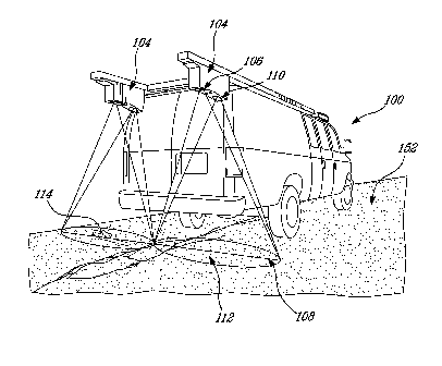
FIG. 1A shows an example vehicle 100 on which is provided the LFOD system
102. This vehicle 100 is adapted to travel, for example, on the runway,
taxiway or apron of an
airport or on a road. Two 3D laser sensors 104 are mounted on the vehicle and
are oriented to
scan the surface to be inspected 152.
¨8¨
CA 02862762 2014-07-25
290405-7
The 3D laser sensor 104 has a field-of-view. The size of the field-of-view
depends
on the optics used in the 3D laser sensor and on the installation height and
orientation of the
3D laser sensors. The field of view of an example installation of the 3D laser
sensors 104 is
shown in FIG. 1B. The laser line projector 106 projects a laser line 108 on
the surface 152.
The camera 110 captures the image of the laser line 108 in its field of
detection 112. A FOD
114 is present on the surface.
The LFOD system can offer a modular approach as to the number of 3D laser
sensors used in order to adapt to the various needs of infrastructure
authorities. In one
embodiment, two 3D laser sensors are provided and cooperate to produce the set
of 3D
profiles of the surface. The field-of-view of the 3D laser sensors can be made
to overlap to
ensure a continuous coverage of the detection zone.
For example, each pair of sensors can scan a transversal width of 4-6 m with a
transversal resolution of 1-1.5 mm. If three pairs are used simultaneously,
the total combined
scanning width is 12-18 m. The 18 m width is advantageous since it ensures
coverage of the
critical landing gear footprint of the Boeing 747-8 Code F and Boeing 747-400
Code E.
In the example sensor installation shown in FIG. 1B, the 3D laser sensors 104
are
installed at an installation height of 2.2 m. They are separated by a
transversal distance of 2 m.
Their combined field of view has a transversal width of 4 m.
An example casing of the 3D laser sensor 104 is shown in FIG. 7. The example
casing dimensions are 428 mm (h) x 265 mm (1) x 139 mm (w), its weight is 10
kg and its
power consumption (max) is 300 W at 120/240 VAC.
In example embodiments, the 3D laser sensor has a sampling rate of 5,000 to
12,000 profiles/s, for example 11200 profiles/s. In some embodiments, 4096 3D
points are
acquired per profile. The vertical resolution is 0.5-1 mm. The depth range of
operation can
reach 250 mm.
As shown in FIG. 2, if the surface to inspect 152 is larger than the width of
the
(individual or combined) field-of-view, the vehicle 100 can travel in a back-
and-forth fashion
¨9--
CA 02862762 2014-07-25
290405-7
154 on the surface to inspect 152 to scan the whole area. Surrounding grounds
156 may be
omitted from the inspection as per the specific requirements of the
application.
As the inspection vehicle is being driven, the LFOD system 102 scans the
surface.
The 3D data scans are transferred to an onboard or remote processing computer.
The
connection between the laser sensors and the processor can be a high-speed
network
connection.
The 3D laser sensor therefore acquires a series of 3D profiles of a
transversal
section of the surface which are then cumulated and aggregated to recreate the
longitudinal
profile of the surface.
The LFOD captures range date. Optionally, intensity data can be acquired
simultaneously. Relevant data on FOD which are detected to be present can be
extracted from
the 3D profiles. Examples of such relevant data include FOD location (linear
reference and/or
GPS coordinates), FOD height (max, min, average), FOD area, etc.
Intensity profiles provided by the LFOD are used to form a continuous image of
the scanned surface. Intensity images can be used to identify the type of FOD
present on the
surface. Intensity images can also be used to detect highly reflective painted
surfaces such as
pavement striping and informational messages as such markings are highly
contrasted
compared to the surrounding pavement. A threshold operation can thus be
applied to extract
the location of the marking. With the proper pattern recognition algorithms,
various markings
can be identified and surveyed.
The intensity data can be transformed into an image in grey-scale. An
intensity
image is formed by the aggregation of a plurality of transversal intensity
profiles along the
longitudinal direction. If an intensity value of 0 is assigned to the color
black and an intensity
value of 255 is assigned to the color white, the intensity data can be
represented in varying
shades of grey. Alternatively, the intensity data can be obtained from a color
or a black and
white image obtained using an external camera or device or a range image.
- 10 -
CA 02862762 2014-07-25
290405-7
The range data acquired by the LFOD system measures the distance from the
sensor to the surface for every sampled point on the road. The range data,
also referred to as
3D data, includes transversal, longitudinal and elevation information for each
point in the 3D
profile. A range image is formed by the aggregation of a plurality of
transversal range profiles
along the longitudinal direction. Elevation data can been converted to a gray
scale. In range
images, the lighter the point, the higher the surface is; so features above
the surface (such as
FOD) appear light grey or white in range images whereas features whose depth
extends
beneath the surface (such as cracks, raveling, rutting, potholes, etc.) appear
as dark grey or
black. FOD are sometimes readily visible on range images with the naked eye.
However, FOD
detection is actually performed using automated algorithms which analyze the
3D range data
and apply minimum criteria for detection.
The range image can be combined with the intensity data to create a 3D image
including the transverse position, the longitudinal position, the elevation
and the intensity data
for all acquired points. The 3D image is useful for reporting purposes since
it provides a
detailed graphical representation of the surface to inspect. The 3D image
gives a sense of
depth using the range data and ensures that the object is visible by using the
intensity data.
FIG. 4A and FIG. 5A show a picture of a FOD planted on a surface to inspect.
In
Fig. 4A, the FOD is a set of keys in a rut of the pavement surface. In FIG.
5A, the FOD is a
wrench. As will be readily understood, the picture of FIG. 4A and 5A is not
required for the
processor to carry out its detection of FOD. The picture may be useful for
display to an
operator but is superfluous in most cases. FIG. 4B and FIG. 5B show 3D images
corresponding to the pictures of FIG. 4A and FIG. 5A. FIG. 6 is a range image
showing a
variety of FOD.
OPTIONAL SENSORS
In one embodiment, the LFOD system also acquires pictures of the surface being
profiled by the 3D laser sensors. The pictures can be captured by a standalone
camera (not
shown). Pictures from the cameras can be digitized by high-speed frame
grabbers and
- 11 -
CA 02862762 2014-07-25
290405-7
compressed, for example to 1/40th of their raw size, using data compression
algorithms, such
as lossless data compression algorithms, to minimize data storage
requirements.
In one embodiment, the LFOD system also has at least one right-of-way imaging
camera 118 for acquiring images of the surface for visual inspection and
detection of poor
surface conditions such as excessive vegetation, excessive amounts of FOD,
poor drainage,
etc. which could impede the displacement of the 3D laser sensors. The right-of-
way camera
118 can also be used to acquire pictures of the surface as discussed above.
In one embodiment, the LFOD system also has at least one geographical location
sensor for acquiring geographical data for the 3D profiles. The geographical
location sensor
has at least one antenna 120. The geographical location sensor can be provided
by a Global
Navigation Satellite System (GNSS) such as GPS, GLONASS or Galileo.
In one embodiment, the LFOD system also has an optical encoder used as an
odometer to synchronize sensor acquisition as the inspection vehicle 100
travels across the
surface 152. An example of such an optical encoder is a Distance Measuring
Interval Module
(DMI) wheel encoder 130. The DMI can control image capture rates for the 3D
laser sensors
104 and other cameras (104, 118 and others) and geographical data acquisition
rates for the
geographical location sensor 120.
PROCESSOR
In the processor, FOD detection algorithms scan the 3D profiles for presence
of
debris which exceed operator-specified thresholds for minimum height and area.
Objects
meeting the minimum height and area criteria are recorded as FOD and their
position as well
as height, area and an actual image of the object can be recorded for each
detected FOD.
In other words, the processor is adapted for receiving the 3D profiles of the
surface from the 3D laser sensor, analyzing the 3D profiles using a parametric
surface model
to determine a surface model of the surface, identifying pixels of the 3D
profiles located
above the surface using the surface model and generating a set of potential
FOD by applying a
¨ 12 ¨
CA 02862762 2014-07-25
290405-7
threshold on the pixels located above the surface model to identify a set of
at least one
protruding object.
The range data is used to detect FOD. The intensity data is optionally used to
filter
the detection made using the range data and/or to prepare a clearer detection
report for an
operator.
FIG. 3 shows example screen shots of a detection software interface where the
results of the automatic FOD detection 162 are displayed to an operator (see
FIG. 3B) together
with a picture 160 of the scene (FIG. 3A). In the scene, a plurality of FOD
having different
textures, colors, heights, areas, durability and flexibility are present and
can be seen on the
picture 160. After automatic FOD detection, the system has identified the
objects as being
FOD and has graphically indicated the presence of a FOD on image 162 by
coloring the pixels
corresponding to the detected object and by circling the area in which the
object is located.
The detected object can be identified for display to an operator on either the
intensity image,
the range image or a 3D image combining the range data with the intensity
image.
FIG. 4C shows a detected set of keys and FIG. 5C shows a detected wrench. The
detected objects are identified on the 3D images of FIG. 48 and FIG. 5B
respectively. As will
be readily understood, the detected objects could be identified on a picture,
a range image or
an intensity image of the scene.
From a pavement condition inspection perspective, most features are located in
the
high-spatial frequency portion of the range data. FIG. 8A shows a 2 m-wide
transverse range
profile. The general depression of the range profile corresponds to the
presence of a rut 170,
the sharp drop in the center of the profile corresponds to a crack 172 and the
height variations
around the surface model line correspond to the macro-texture of the surface
174. The
parametric surface model determines the surface model using the actual surface
condition
assessment. The parametric model is adapted to fit and track the 3D data to
take into
consideration active contour models, snakes and balloons, in order to
delineate the surface 176
from the FOD to detect.
- 13 -
CA 02862762 2014-07-25
290405-7
FIG. 8B shows a 2 m-wide transverse intensity profile. In the intensity
profile, the
rut, crack and macro-texture of the surface are not apparent. However, a
marking 178 which
has high reflectivity is apparent. This marking 178 was not apparent on the
range profile of
FIG. 8A because the layer of paint used to create the marking has negligible
thickness. The
detection of the marking from the intensity image can allow advanced filtering
of the
detections made by the processor using the range data (3D profiles).
The LFOD system can generate a surface condition assessment. Algorithms for
the detection and quantification of a wide range of pavement distresses are
available
including: longitudinal profile, roughness, transverse profile, rutting,
potholes, longitudinal
cracking, transverse cracking, pattern cracking, joint seal failure, concrete
slab faulting,
macrotexture, bleeding, raveling. These data items can be used to support a
full pavement
management program for an airport's paved surfaces using Micr0PAVERTM or other
Pavement Management System software applications.
A severity rating can be given to each detected FOD based upon its height and
area with the operator being able to configure the height and area ranges
according to multiple
levels of severity such as high, medium and low. An example graphical
representation of the
severity level is shown in FIG. 9. High severity FOD is marked in images using
a red color
(see FIG. 9A), medium severity is marked using an orange color (see FIG. 9B)
and low
severity FOD is marked using a green color (see FIG. 9C).
FIG. 10 shows another example of a severity rating assigned to each detected
FOD
for a detection of FOD in a water puddle. In FIG. 10A, the picture of the FOD
is shown. In
FIG. 10B, the intensity image is shown. Since most FOD in FIG. 10A are
metallic, they reflect
light are therefore appear very clearly on the intensity image of FIG. 10B,
even if partly
submerged in the water puddle. In FIG. 10C, the intensity image is
superimposed with the
detection markings (surrounding circle and colored object). Moreover, the
severity rating
color code detailed above is used to indicate which FOD present a higher risk.
As will be readily understood, the processing of the acquired 3D profiles to
detect
the FOD can be done in real-time, as the data is being acquired by the 3D
laser sensor.
¨ 14 ¨
CA 02862762 2014-07-25
290405-7
Alternatively, the detection can be performed off-line, after acquisition has
ended and data has
been retrieved from the LFOD system.
It will be understood that the connection between the LFOD system and the
processor which detects the FOD can be a wired or wireless connection. The
processor can be
provided as part or external to the LFOD system. Additionally, the
communication between
the processor and the LFOD system can be carried over a network. Processing of
the data can
be split in sub-actions carried out by a plurality of processors for example
using cloud
computing capabilities.
In an example embodiment, the thresholds listed in Table 1 are used by the
processor:
Minimum size FOD Surface area between 1.5 cm2 and 5.0cm2
Average height between 3 mm and 5 mm
Medium size FOD Surface area between 5.0 cm2 and 20 cm2
Average height between 5 mm and 10 mm
Large size FOD Surface area between 20 cm2 and 50 cm2
Average height greater than 10 mm
Extra large size FOD Surface area greater than 50 cm2
Average height greater than 10 mm
Table 1. Example thresholds for the detection of FOD
KNOWN FIXTURES FILTER
In one embodiment, known object data containing information about a previously
known object can be provided to the processor. The known object data can
include height,
area, shape and geographical location data about known objects, such as in-
pavement fixtures.
If the set of potential FOD includes a potential FOD whose characteristics
correspond to one
element of the known object data, the potential FOD can be identified as a
known object and
filtered out of the list of potential FOD. Example surface fixtures are a
transition (drop-off,
edge, curb), a rail, a rail tie, a lighting module, a drain port, a flag pole,
a weather instrument,
- 15 -
CA 02862762 2014-07-25
290405-7
a sign, etc. Algorithms can be used to determine if a potential FOD is
sufficiently similar to a
known object in the known object database to be filtered out.
For example, if lighting fixtures are known to be circular and to have a
certain
diameter, the known fixtures filter may identify potential FOD objects having
a circular or
semi-circular shape and having a diameter corresponding to the diameter of the
lighting
fixtures (within an acceptable precision range) to be these known lighting
fixtures. The
potential FOD objects can then be discarded as being known. If the
geographical location of
the potential FOD object and of the known lighting fixtures are known, this
additional
information can further be used to discard the potential FOD as being known.
The detection of the marking from the intensity image can allow advanced
filtering of the detections made by the processor. For example, objects
detected at regular
intervals on a marking can be excluded from the FOD list if it is known that
lighting fixtures
are present on the marking at regular intervals. However, should objects
matching the shape of
the lighting fixtures be detected outside of the marking, a detection of a
displaced/errant
lighting fixtures can be included on the FOD list.
Other filters can be implemented using correlation, template matching, neural
networks, supervised classification, etc. to refine the identification of the
FOD.
REPORT
A FOD detection generator is used for providing detection information about
the
potential FOD. This FOD detection generator can provide detection information
to an operator
via a graphical user interface or other user interaction module, such as a
speaker adapted to
produce an audible alarm. The FOD detection generator can also store the
detection
information in a database for future access by an operator.
If a graphical user interface is used, the system can indicate the presence of
a FOD
using a plurality of ways. In some embodiments, the presence of a FOD is shown
on an image
by coloring the pixels corresponding to the detected object and by circling
the area in which
the object is located. The detected object can be identified for display to an
operator on either
- 16 -
CA 02862762 2014-07-25
290405-7
the intensity image, the range image or a 3D image combining the range data
with the
intensity data. Examples of such images prepared for display to an operator
include FIG. 3B,
FIG. 4C, FIG. 5C, FIG. 10C.
Alarms can be set by the operator to trigger only upon the detection of FOD of
a
minimum height and area. This is particularly useful considering the high
sensitivity of the
system and its ability to detect FOD down to a size of a few millimeters. The
GPS
coordinates, dimensions and images of small FOD which does not meet the
airport-set criteria
for immediate retrieval can be stored and used to create a targeted work
program for weekly
runway sweeping or vacuuming.
The advantage of performing the processing of the 3D profiles in real-time
while
the vehicle is carrying out the scan of the surface is that identified FOD can
be readily
collected by an operator seconds or minutes after the FOD has been detected.
The inspection
of the surface therefore guides the sweeping and/or vacuuming of the surface
in real-time. The
operator can travel onboard the inspection vehicle, can walk or run along the
inspection
trajectory or can travel in a separate vehicle which may be adapted for
cleaning of the surface.
A number of different data elements are available as outputs from the system
so as
to allow the user to better manage their risk due to FOD. For each detected
FOD the system
can record the following: FOD location (linear as well as latitude, longitude
and elevation),
FOD height (max, min and average), FOD area or size, FOD shape, images of the
FOD
(range, intensity and 3D), FOD "severity rating" (High, Medium, Low). The
system can also
output data concerning the objects which did not meet the criteria to be
identified as FOD but
which were still identified by the system before being filtered out.
Data can be stored in an XML data format which can be readily imported into a
variety of database and/or file formats such as Microsoft Access, Microsoft
SQL, Oracle,
Microsoft Excel, etc.
¨ 17 ¨
CA 02862762 2014-07-25
290405-7
Over time, a database of detected FOD can be created documenting the date and
time, location, shape, size and type of FOD detected at the airport. This
information can serve
as a valuable input into an airport's Safety Management System.
Additionally, a report can be generated using maps, such as Google EarthTM
maps
or high-definition transport infrastructure aerial maps, such that the
locations of detected FOD
are highlighted on a satellite or aerial photo along with a data file for each
item detailing the
FOD's key characteristics. FIG. 11 shows two examples of such maps overlapped
with data
about detected FOD.
In FIG. 11A, the FOD has a high severity rating. The aerial photo 180 bears an
indicator 182 indicating where a FOD is located. Other markings 184 show where
known
fixtures are located. A data file 186 contains the intensity image 188 on
which the FOD 190 is
color coded (red) and circled for emphasis. A table 192 gives information
about the FOD such
as the FOD area (61 mm2), the maximum height of the FOD (39.10 mm), the
average height
of the FOD (12.40 mm), the GPS coordinates of the FOD including longitude,
latitude and
altitude and the bounding box data including the MinX, MaxX, MinY and MaxY
data.
In FIG. 1111, the FOD 194 has a low severity rating. The aerial photo 180
bears
indicators 182, 194 indicating where FOD are located. Other markings 184 show
where
known fixtures are located. A data file 186 contains the intensity image 188
on which the
FOD 196 is color coded (green) and circled for emphasis. A table 192 gives
information about
the FOD such as the FOD area (13.93 mm2), the maximum height of the FOD (14.40
mm), the
average height of the FOD (6.30 mm), the GPS coordinates of the FOD including
longitude,
latitude and altitude and the bounding box data including the MinX, MaxX, MinY
and MaxY
data.
DEPLOYMENT
The LFOD system can be deployed in a number of ways depending on the
operational needs of the user. During peak hours, when the time between take-
offs and
landings is at a minimum, the system can be operated in a single pass mode
with the inspector
¨ 18 ¨
,
CA 02862762 2014-07-25
290405-7
following the same survey route as they normally would for a visual survey. In
this way the
inspector can concentrate on visually scanning the surface of the runway at
its edges for the
presence of FOD while the LFOD scans the middle portion of the runway using
its high-speed
lasers and automated algorithms.
During off-hours (e.g., at night-time during no fly times), the LFOD can be
used
to quickly perform a detailed FOD survey that would be practically impossible
to perform
using visual methods due to lighting conditions. In these situations the
inspector can scan the
runway surface using just a few passes to ensure 100% coverage at 1 mm
scanning resolution.
FLOW CHART
FIG. 12 is a flow chart of example steps of the method for detection of FOD.
The
first step is the acquisition of 3D profiles 200. The parametric modeling of
the surface is then
carried out 202. This yields a model of the surface which follows its
characteristics and takes
into account transversal and longitudinal features of the surface itself It
allows to determine
the height of the modeled surface at all points.
Next, the thresholding of the 3D data points above the surface model 204 is
carried out. This thresholding is done on the height of the 3D data points.
All data points
below a threshold are no longer considered as belonging to a potential FOD.
All data points
above the threshold are kept as candidates who may belong to a potential FOD.
A clustering of connected points 206 is done to group the candidate points
into
objects using a proximity criteria. This yields an object list.
The measurement of size, height, area, volume, location, etc. of the clusters
is
determined 208 from the 3D profiles and information which may come for
additional sensors
such as a GPS. The object list is augmented with the object feature
information.
Then, the objects on the object list are filtered 210. They can be filtered
based on
dimensional and size constraints pre-determined by the system operator and/or
filtered using
a known object list which give information about known objects including their
characteristics
-19-
CA 02862762 2014-07-25
290405-7
and their location. Filtering the known objects may include matching locations
of objects on
the object list with locations for known objects and/or correlating the
dimension or the shape
characteristics.
The remaining objects are identified FOD. A severity rating may be assigned to
the FOD 212 based on their location and/or dimension characteristics and can
be added to the
detection information about the FOD.
The FOD list with their features and optional severity rating can be stored
and/or
outputted for use by an operator. Optionally, the filtered out objects may
also be stored and/or
outputted.
BLOCK DIAGRAM
FIG. 13 is a block diagram of example components of the detection system.
3D sensors 300 acquire 3D profiles. The 3D profiles are transmitted to a
processor
which carries out data processing. The processor includes the following
components. A
surface model determiner 304 receives the 3D profiles and generates a surface
model for the
surface to be inspected. The surface model and the 3D profiles are transferred
to a 3D data
point thresholder 302 which outputs the thresholded points which are above the
surface and
which may belong to protruding objects. An object cluster assembler 306
assembles the
neighboring thresholded points into object cluster and creates an object list.
The object feature
builder 308 uses data from the 3D profiles, from an optional GPS sensor 310
which provides
GPS data and from a database of severity constraints 312 to generate features
data for each
object on the object list. The object list with the features is transmitted to
the object sensitivity
filter 314 and the known object filter 318. The object sensitivity filter 314
uses dimensional
constraints obtained from a database of dimensional constraints 316 to filter
out objects on the
object list. For example, objects which are too small to be marked as FOD can
be eliminated.
The known object filter 318 receives known object data from the database of
known objects
320 to filter out objects which are known to be present on the surface and
which do not need
to be reported as FOD. The filters can work in parallel or in series and may
exchange their
¨ 20 ¨
CA 02862762 2014-07-25
290405-7
filtered lists. The known object filter 318 is optional and all objects with a
size sufficient to be
kept as a potential FOD could be identified as a FOD regardless of whether
their presence is
known. The filtered lists are provided to a FOD list generator 322 which can
output of list of
FOD with their relevant features.
The embodiments described above are intended to be exemplary only. The scope
of the invention is therefore intended to be limited solely by the appended
claims.
¨ 21 ¨