Note: Descriptions are shown in the official language in which they were submitted.
CA 02866174 2014-09-02
WO 2013/128212 PCT/GB2013/050526
1
Fault Detection for Pipelines
The present invention relates to the detection of faults or otherwise
assessing the integrity
of structures such as pipelines.
Structural problems with existing pipelines are of significant concern to a
pipeline
operator. An aging pipeline infrastructure means that such problems are
generally
becoming more prevalent over time. The cost of excavating and replacing or
repairing
existing pipeline is considerable, not only due to the cost of the engineering
works but also
due to the potential need to shut down a pipeline whilst works are carried
out.
This problem has been documented in the past and there have been proposed
methods
to allow pipelines to be inspected such that faults can be detected and
maintenance or
overhaul work to be scheduled in a manner which minimises the impact for the
pipeline
operator.
Existing techniques for pipeline inspection involve insertion of an In-Line-
Inspection (ILI)
tool such as a pipeline inspection gauge (commonly referred to as a 'pig')
into the pipeline.
Pigs have historically been used for cleaning pipelines but have, more
recently, been
provided with sensors and associated electronics for detecting faults, such as
cracks,
corrosion or other geometric defects in the wall of the pipeline. It is also
known to use
calliper pigs to determine any deviation of the cross-section of the pipe from
a desired,
circular profile. Such pigs are propelled along the pipeline and record a
plurality of
measurements along the desired section of pipeline.
Whilst it is possible to insert pigs into pipelines for a number of industries
and/or pipelines
without stemming the flow along the pipeline, this is not always the case. In
addition to the
material conveyed by the pipeline, any of the geometry, curvature and/or
valves within a
pipeline can make pigging impossible. If a pig becomes stuck part way along
the pipeline
section under inspection, it will require retrieval, which causes further
problems for the
operator.
Furthermore, and perhaps more importantly, pigging represents an invasive
process and
risks contamination of the pipeline. Hence, even where pigging is possible, it
is generally
desirable to minimise the frequency with which any such activity is
undertaken.
CA 02866174 2014-09-02
WO 2013/128212 PCT/GB2013/050526
2
As an alternative to pigging, Russian Patent RU 2 264 617 discloses a non-
invasive
system for detecting areas of questionable structural integrity within a
pipeline by
recording changes in the magnetic field a short distance from the pipeline.
It is an aim of the present invention to provide a method and system for non-
invasive
assessment of the integrity of a structure, which can offer results having
improved
accuracy and/or which provides an alternative to the use of pigs.
According to a first aspect of the invention, there is provided a method of
assessment of
the integrity of a structure comprising: positioning one or more magnetic
field sensors at a
first location remote form the structure; taking one or more magnetic field
readings at the
first location and a plurality of further locations spaced from the first
location in a known
direction; processing the plurality of magnetic field reading values or a
plurality of
parameter values derived therefrom so as to identify a feature within said
values; and
outputting an indication of said region of reduced structural integrity.
The method may comprise receiving or recording a further data input indicative
of an
operational parameter at said first or further locations; verifying that said
feature
corresponds to the location of a region of reduced structural integrity for
the structure
based on said further data input; and outputting the indication of said region
of reduced
structural integrity in dependence upon said verification.
The output may comprise an indication of the location of said region of
reduced structural
integrity. The indication may be output on a plan, map schematic or other
graphical output
of the structure.
The present invention is particularly advantageous in that it can improve the
accuracy with
which a region of questionable structural integrity can be identified and/or
located. This
allows the invention to be used with greater certainty such that future
maintenance or
repairs works can be scheduled based on the results attained.
The invention can be used as a predictive tool to assess the nature or
severity of an
anomaly detected in the structure. The structure may comprise an accessible,
buried, or
otherwise readily inaccessible structure, such as a pipeline. The known, or
first, direction
may be aligned with a longitudinal axis of the pipeline.
CA 02866174 2014-09-02
WO 2013/128212 PCT/GB2013/050526
3
The method may comprise moving the sensor or instrumentation relative to the
structure
in the known direction and taking one or more further readings at further
locations, at
known distance from said first location.
The method may comprise recording the location of said first and/or further
locations
using a co-ordinate positioning system. The co-ordinate positioning system may
comprise
a satellite positioning receiver. The method may comprise recording values of
latitude and
longitude and/or altitude, typically at each location. The method may comprise
recording
accuracy measurements for each location.
The method may comprise providing a plurality of sensors in an array, the
spacing of each
sensor in the array being known and/or fixed. The array may comprise three or
more
sensors aligned along a common axis. The array may comprise a two-dimensional
array,
having at least two sensors aligned along a first axis and at least two
sensors aligned
along a further axis, said further axis being perpendicular to the first axis.
The array may
comprise a three-dimensional array having at least two sensors aligned in each
of three
perpendicular axes.
The receiving or recording a further data input may comprise recording
magnetic field
values at a plurality of locations, typically using any one of the sensor
arrays defined
above, and determining a change in magnetic field values in at least a first
and a second
direction. The validation may comprise identifying a feature in one of the
plurality of
directions and identifying a corresponding feature in one or more other
(typically linearly
independent) directions. The first and second directions may be opposing
directions (e.g.
to and/or from said first location). The first and second directions may be
perpendicular
directions. Such a process may be performed for first, second and third
directions. Such a
process may be performed in respect of three or more directions, such as four,
five or six
directions, which may comprise any combination of opposing and/or
perpendicular
directions.
In one embodiment the potential feature may be compared or correlated with the
further
data input so as to either confirm or deny the presence of said region of
reduced structural
integrity.
The region of reduced structural integrity may comprise a region of increased
or
decreased stress in the structure. A level or value or type of stress anomaly
in the
CA 02866174 2014-09-02
WO 2013/128212 PCT/GB2013/050526
4
structure may be determined in dependence upon the plurality of magnetic field
reading
values or a plurality of parameter values derived therefrom.
The feature may comprise a peak, trough, zero-crossing, or other similar
feature in the
The method may comprise measuring an inclination of said one or more magnetic
field
sensor, typically about one or more axes. The further data input may comprise
an angular
orientation reading for said sensor at one or more of said locations. The
verifying said
The magnetic field readings may be processed, typically using a computer or
other
The method may comprise receiving or obtaining survey results for the
structure and the
of the structural integrity, for example in dependence upon said verification
step. The
method may comprise outputting a numerical value or score indicative of the
degree of
certainty of verification of the structural integrity. The method may comprise
outputting an
estimated value of internal stress within the structure at said location.
The method may comprise scheduling maintenance or overhaul work for the
structure
dependent on the outputting an indication of reduced structural integrity. The
method may
comprise setting operational parameters or limits for the structure dependent
on the
indication of reduced structural integrity.
CA 02866174 2014-09-02
WO 2013/128212 PCT/GB2013/050526
The method may comprise outputting one or more graphical or textual displays
of the
results of the method, such as a map, plan or schematic of the structure
indicating the one
or more determined locations of reduced structural integrity. The method may
comprise
outputting a plot or chart of magnetic field strength or a parameter derived
therefrom, such
5 as a magnetic field gradient, for example in one or more directions.
According to a second aspect there is provided a method of operation of a
pipeline
comprising the method of the first aspect.
According to a third aspect of the invention, there is provided a system for
assessment of
the integrity of a structure corresponding to the first aspect.
According to a fourth aspect of the invention, there is provided a data
carrier comprising
machine readable instructions for the control of one or more processors to
perform the
steps of the method of the first aspect.
Any of the preferable features described above with reference to any one
aspect may be
applied to any further aspect, wherever practicable.
Practicable embodiments of the present invention are described in further
detail below by
way of example only with reference to the accompanying drawings, of which:
Figure 1 shows a schematic flow diagram of the occurrence of change in
magnetic field
surrounding a structure;
Figure 2 shows a schematic three-dimensional view of an apparatus for
determining a
change in magnetic field according to an example of the invention;
Figure 3 shows the basic architecture of an apparatus for determining a change
in
magnetic field according to an example of the invention;
Figure 4 shows a sensor array according to a first example of the invention;
Figure 5 shows a sensor array according to a second example of the invention;
CA 02866174 2014-09-02
WO 2013/128212 PCT/GB2013/050526
6
Figure 6 shows a schematic of an example of results obtained according to one
example
of the present invention;
Figure 7 shows a flow diagram of data handling steps performed according to an
example
of the invention;
Figures 8A to 8D show plots of magnetic field gradient in different directions
in the vicinity
of an anomaly;
Figure 9 shows plots of position data for a pipeline recorded according to one
example of
the invention;
Figure 10 shows a graphical output of a pipeline surveyed in accordance with
an example
of the invention;
Figure 11 shows an example of a graphical output of a stress model of a
structural
anomaly determined as an output of the invention; and,
Figure 12 shows a detailed three-dimensional view of a model of the magnetic
field in the
vicinity of the anomaly of Figure 11.
The present invention is derived from the understanding that it is possible to
determine an
indication of the stress experienced by a structure, such as a pipeline,
remotely there-from
by measurement of changes in the magnetic field in the vicinity of the
structure. This
determination can be used to identify regions of high and/or abnormal stress
concentration and thereby identify unsafe regions for which further
investigation or
repair/maintenance works are required.
Turning firstly to Figure 1, there is shown a schematic diagram of the steps
involved in a
change in the condition of a structure leading to a change in the surrounding
magnetic
field. The present invention is concerned with the occurrence of a geometric
or
metallurgical (e.g. corrosion) anomaly in a metallic (typically ferromagnetic)
structure such
as, in this example, in the wall of a pipeline. Such an anomaly may occur due
to a
particular event or else over a period of time, for example due to movement in
the
surrounding subsoil; due to cyclic loading by seasonal changes in temperature;
and/or
due to the pressure/flow regime within the pipeline.
CA 02866174 2014-09-02
WO 2013/128212 PCT/GB2013/050526
7
The anomaly in the pipeline leads to a local stress concentration or profile
focussed about
the anomaly. This stress concentration has been found by the inventors to
cause a
measurable change in the magnetic field surrounding the pipeline according to
the inverse
magnetostrictive (or Villari) effect. Thus the dipoles within the structure
become
misaligned from their at-rest state, thereby generating a global or
macroscopic
magnetisation of the structure in the vicinity of the anomaly. The nature of
the resulting
magnetic field will vary dependent on the crystal alignment within the
structure and the
direction of the tensile or compressive loading of the structure.
Field Apparatus
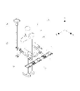
An example of equipment 10 used to detect and measure changes in the magnetic
field
due to the above-described phenomena is shown in Figure 2. The equipment 10 in
this
example is arranged to be portable by mounting the relevant instruments to a
frame 12
such that the assembly can be carried by an individual 14. The
instruments/sensors
comprise, in brief, a plurality of magnetic field sensors 16 assembled in a
predetermined
array, as will be described in further detail below, and a position
determining system 18.
The sensors in this embodiment comprise directional or vector magnetometers,
such as
fluxgate magnetometers, which each measure the magnetic field in the X, Y and
Z
directions. In this example, the sensors create an analogue voltage output
that is
proportional to the magnetic field component in each direction. The particular
magnetometers selected in this embodiment comprise Three-Axis Fluxgate
Magnetic
Field Sensors. These magnetometers have been found to have beneficial low
noise and
low power characteristics, although it may be possible to use other vector
magnetometers.
The term "sensor" as used herein may include the use of a plurality or
sensors, which may
for example be co-located in the form of a sensor device.
The sensors 16 are mounted on one or more rigid spacer arm 20, which may be
referred
to herein as a sensor arm, such that the relative positions and spacing of the
sensors are
known and remain fixed during use of the equipment. In this regard, the
sensors are
mounted onto support blocks which in turn mount onto the sensor arm 20. The
sensors in
the present embodiment are located in front of the operator. These are located
in the left,
centre and right hand mounting blocks along the sensor arm 20.
CA 02866174 2014-09-02
WO 2013/128212 PCT/GB2013/050526
8
The position determining system comprises a receiver arranged to receive
electro-
magnetic signals, typically from a plurality of satellites, such that an
associated processor
can determine the location of the receiver based on the location of the signal
transmitters
and the time taken for the received signals to reach the receiver. A further
support 22 arm
is used to maintain the position determining system 18 above the sensors 16
when
oriented for use as shown in Figure 2.
An axis system can be established as shown in Figure 2, wherein the direction
of travel in
use is substantially in the Y direction. The apparatus is oriented in use such
that the Y
direction is substantially parallel with the longitudinal axis of a pipeline
being assessed. In
this context, the arm 20 and array of sensors 16 extend in a direction (i.e.
in the X
direction) which is lateral/perpendicular to the direction of travel and/or
the longitudinal
axis of the pipeline. The sensors 16 in this configuration lie in a
substantially horizontal
plane. The position determining receiver 18 is maintained in a known spaced
relationship
with respect to the sensors 16 above the sensors, in the Z direction. In this
example, the
position determining receiver 18 is also behind, and to the left hand side of
the operator
14 and/or the centre of the array of sensors 16.
The frame 12 and the further arm 22 maintain the desired spacing of the
sensors and
receiver 18 during use of the equipment. This spacing is important since it is
used in
determining the precise location of the sensors 16.
It is also important that the receiver 18, which comprises electronic
equipment is suitably
displaced relative to the sensors so as to avoid interference with the
magnetic field
caused by the pipeline which will typically be below the sensors 16 in use. In
addition, the
receiver 18 is positioned above the operator to maintain the receivers direct
view of the
sky.
The arm 20, frame 12 and further arm 22 comprise a support structure that is
preferably
formed of materials which are transparent with respect to the magnetic field
as far as
possible. Carbon fibre and/or plastic materials are used to this end. In the
particular
embodiment of Figure 2, the support structure is formed of carbon fibre tubes,
coupled
together using plastic joints. Where metal components are necessary, aluminium
is used
as far as possible to minimise distortion of the surrounding magnetic field.
CA 02866174 2014-09-02
WO 2013/128212 PCT/GB2013/050526
9
Whilst it is apparent from Figure 2, that the support structure is configured
to allow it to be
carried or worn by an operator on foot, it is possible according to other
embodiments that
the support structure could also be arranged for mounting on a vehicle such as
a trailer or
cart or similar wheeled structure. The carrying of the apparatus on foot is in
many ways
preferred due to the varying terrain which is often experienced when following
the path of
a pipeline above ground.
Furthermore, the operator will typically steady him/herself when carrying the
apparatus
such that the sensors will be maintained substantially in the desired
horizontal orientation
when taking magnetic field readings. To further guarantee a predictable
orientation of the
sensors 16, it is possible to provide the support arm 20 and/or structure with
one or more
orientation indicators, such as a spirit level, such that the operator can
confirm or adjust
the orientation accordingly. Additionally or alternatively it is possible to
provide the support
structure with a levelling mechanism, allowing the support arm to pivot with
respect to the
remainder of the support structure and thereby maintain a desired,
substantially horizontal
orientation.
Whilst the above support structure embodiments may help to retain the sensors
in a
predictable orientation, the inventors have determined that the accuracy of
the readings
can be improved by providing an orientation sensor, such as an inclinometer,
to determine
the angular orientation of the array with respect to the horizontal and/or
vertical axis.
Figure 3 shows the key components that comprise the electronic system of the
apparatus,
in order to allow collection of the required data by a control unit 24. The
sensors 16
comprise vector magnetometers, each capable of measuring the magnetic field in
three
dimensions.
The position-determining system comprises the aforementioned receiver 18,
which is
portable with the apparatus and comprises a high resolution global navigation
satellite
system (GNSS). Such a system utilises signals from multiple satellite
positioning
constellations to provide increased accuracy over using a single satellite
constellation.
A static base unit 26 is also provided which also comprises a GNSS receiver
module. The
static base unit functions in the manner of a conventional satellite
positioning unit in that it
receives a plurality of satellite signals which are used to determine its
location. However
the fixed nature of the base unit 26 allows a highly accurate position
determination for use
CA 02866174 2014-09-02
WO 2013/128212 PCT/GB2013/050526
as a reference point. The base unit 26 calculates and transmits satellite
correction data to
the mobile receiver 18 such that it can correct its position determination
with reference to
the base unit 26 in the manner of a so-called Real Time Kinematic (RTK)
system. The
base unit monitors errors in the received satellite signals and transmits real
time
5 corrections to the mobile unit 18, typically over a UHF radio link. In
this regard, either unit
may have a plurality of antenna. Using this technique, the position
determination can be
carried out with a relative accuracy between the two receivers of below 1 cm
and typically
approximately 15mm.
10 The receivers also record the raw satellite data so that, should the
radio link be lost,
corrections can be applied using post processing software.
The inventors have found this accurate positioning capability to be highly
beneficial for the
location of pipeline anomalies with a greater degree of certainty that can
allow meaningful
action to be taken in response to those findings.
The system comprises an analogue-to-digital converter (ADC) 28 for digitising
the
analogue output signal of the magnetometers 16. In this embodiment, nine
channels are
required to digitise the output of the three magnetometers in each direction.
Each ADC is
capable of digitising eight signals and thus two ADC chips are used to
digitise the outputs
from the magnetometers. This also allows some redundancy to accommodate
further
sensor arrays as will be described in further detail below, although further
ADC
chips/channels could be added as necessary. The ADCs are preferably selected
to offer
high resolution and low noise. 24-bit ADCs are used in this embodiment.
Analogue filtering is performed on the magnetometers output before
digitisation to remove
undesired frequencies, such as, for example, 50 or 60 Hz interference from
power lines
and/or general electronic noise such as that present due to digital
electronics and radio
waves. Additional or alternative filtering steps may be used to eliminate
background or
environmental effects on the magnetic field. Such filtering may allow the
invention to be
used in a variety of different environments (e.g. at different altitudes, on
land, in enclosed
spaces and/or underwater).
An inclinometer 30 may be provided in this embodiment to provide real-time
indication of
the angular orientation of the magnetometer array relative to one or more of
the X, Y
and/or Z axes. In this embodiment a reading of angular inclination relative to
each of those
CA 02866174 2014-09-02
WO 2013/128212 PCT/GB2013/050526
11
axes is taken. A microelectromechanical system (MEMS) based inclinometer may
be used
for this purpose and preferably a precision, triaxial device.
The inclinometer is typically mounted on the sensor arm 20 such that its
relative
orientation with respect to the magnetic field sensors is fixed.
A control unit 24 is provided on the support structure as shown in Figure 2,
typically on a
cross bar or other support formation in front of the user.
The control unit 24 receives and manages the incoming data signals from the
magnetometers (via the ADC) as well as the GNSS receiver 18 and, optionally,
also the
inclinometer output. The control unit 24 comprises one or more processor 32.
In this
embodiment a Field Programmable Gate Array (FPGA) is used, which provides a
flexible,
reprogrammable device that is provided with custom digital logic for the
purpose of the
present invention. Alternatively, the processor 32 could be realised using a
dedicated
microprocessor integrated circuit.
In the current configuration the FPGA contains two microprocessors and custom
real-time
digital interface to the ADC chips 28. The first control unit processor is an
autonomous
processor that receives and interprets data from the satellite positioning
system 18. This
processor directly interfaces to the main processor so that the satellite
positioning
parameters are updated in real-time (i.e. without delay, or else wherein any
delay is
sufficiently small that it would not significantly affect the accuracy of any
readings taken
for a given location).
The main processor 32 controls or coordinates the entire operation of the
instrument 10,
with the primary function being to record magnetometer and satellite
positioning data to a
memory device, typically in real-time. This is achieved by co-ordinating
concurrent
readings for the magnetic field (typically in all directions) with position
data and time
stamping a memory entry or record of all those readings. The memory entry may
also
comprise the current inclinometer reading. Such co-ordinated, time-stamped
data capture
from all sensors facilitates effective processing of the data at a later time.
Since a
significant volume of data can be gathered for any single survey, it will be
appreciated that
the reliability of the data for later processing is of particular importance.
CA 02866174 2014-09-02
WO 2013/128212 PCT/GB2013/050526
12
In addition to the main processor 32, the control unit comprises a non-
volatile data store
34, which may take the form of a USB Flash drive, and a power source, in the
form of a
rechargeable battery 36. The control unit preferably also comprises a visual
display unit or
screen, via which pertinent information can be provided to the operator, such
as any, or
any combination of, battery life, inclination readings, position information
and/or field
strength readings.
During use, the operator walks along the path of a, typically buried, pipeline
in the Y
direction with the sensors 16 oriented and spaced in the X direction as shown.
The
known, fixed spacing of the sensors 16 is important to note, as will be
discussed below.
The parameters recorded by the control unit comprise any, or any combination,
of: the X,
Y and Z data from each magnetometer (identified in the further figures as
parameters X1,
Yl, Z1, X2, Y2, Z2, X3, Y3 and Z3); GNSS Date, Time, Longitude, Latitude,
Altitude;
Satellite Positioning Fix Mode; Number of satellites used for positional
computation;
Horizontal dilution of precision (HDOP); RMS latitude error [meters]; RMS
longitude error
[meters]; RMS altitude error [meters]; and Inclination about X, Y and Z axes.
Recording the RMS error of each measurement provides confidence in the
absolute
position of each magnetic field measurement, which data is not available from
single
receiver GNSS systems. As the data is saved to the USB Flash device, error
checking
information is appended to each data record so that any data corruption can be
detected
at a later time and the corrupted data record can be subsequently removed.
Additionally, the main processor outputs positional and status information to
the control
unit display.
In embodiments which include an inclinometer system, the instantaneous angle
of the
sensors is determined, which may also be time stamped and recorded in the
manner
described above.
Magnetic Field Sensor Arrays
Figure 4 shows the arrangement of magnetic field sensors shown in Figure 2 for
detecting
the direction and strength/magnitude of the external magnetic field.
Accordingly each
CA 02866174 2014-09-02
WO 2013/128212 PCT/GB2013/050526
13
sensor is a three-dimensional sensor in that it can record the magnitude of
the magnetic
field in the X, Y and Z directions.
In this embodiment, three such sensors 16A, 16B and 160 are provided in a
linear array.
The sensors 16A, B and C are aligned with respect to the X axis, such that the
Y and Z
axes are perpendicular to the linear array of sensors. Each of the sensors is
spaced from
the adjacent sensor by an equal, fixed distance, 'd'.
This arrangement of sensors is used to determine the rate of change of the
magnetic field
in the X direction, which typically represents a lateral direction across the
pipeline, when
the Y axis is the direction of travel along the pipeline. However it will be
appreciated that
the array of Figure 4 could alternatively be oriented in the Y or Z axes if
the rate of change
in those axes is required. Whilst it will be noted that a minimum of two
sensors could be
used to measure a gradient, the inventors have determined that the use of
three sensors
provides beneficial results as will be described below.
Further embodiments of sensor arrays in accordance with the invention are
described with
reference to Figure 5. In one such embodiment a further sensor 16D is
provided, which is
spaced by the same distance, 'd', from one of the sensors 16A, B or C. Ideally
the sensor
16D is adjacent the middle sensors 16B. However, unlike the linear array of
Figure 4, the
further sensor 16D is spaced from the other sensors in the Y direction. Thus
the combined
sensors 16A-D now define a two-dimensional, or planar, array extending in the
XY plane.
The known, fixed distance between the sensors 16D and 16B allows a
corresponding
magnetic field gradients (i.e. for all three axes) to be determined in the Y
direction.
Whilst sensor 16D is provide in the positive Y direction (i.e. in the
direction of travel), it
could also be provided in the negative Y direction (i.e. behind or trailing
the array 16A-C).
Additionally a further sensor 16D could be provided in both the positive and
negative Y
directions with respect to sensor 16B so as to define a three sensor linear
array extending
in the Y direction.
In another embodiment, further sensor 16E is provided, which is spaced by the
same
distance, 'd', from one of the sensors 16A, B or C. Ideally the sensor 16E is
adjacent the
middle sensors 16B. However, unlike the linear array of Figure 4, the further
sensor 16D
is spaced from the other sensors in the Z (typically substantially vertical)
direction. Thus
CA 02866174 2014-09-02
WO 2013/128212 PCT/GB2013/050526
14
the combined sensors 16A-C and E now define a two-dimensional, or planar,
array
extending in the XZ plane.
The known, fixed distance between the sensors 16E and 16B allows a
corresponding
magnetic field gradients (i.e. for all three axes) to be determined in the Z
direction.
Whilst sensor 16E is provide in the positive Z direction (i.e. upwards), it
could also be
provided in the negative Z direction (i.e. downwards). Additionally a further
sensor 16E
could be provided in both the positive and negative Z directions with respect
to sensor
16B so as to define a three sensor linear array extending in the Z direction.
As shown in Figure 5, further sensors 16D (in the Y direction) and 16E (in the
Z direction)
are provided so as to provide a three-dimensional array, in which each sensor
is spaced
from an adjacent sensor by an equal distance in either of the X, Y or Z axes.
As described
above, such an arrangement could be supplemented with further sensors in the
negative
Y and Z directions.
Whilst the above embodiments can provide up to three sensors aligned in each
axis/direction, it is to be noted that further sensors could be provided in
any or all of those
directions to improve the accuracy of gradient determination and/or identify
any spurious
sensor readings.
In one embodiment, the field strength for each sensor is recorded such that
the gradient
between all the individual sensors of the array can be determined.
Additionally or
alternatively, the gradients between the individual sensors may be recorded by
the control
unit. The gradient between sensor 16A and 16B is determined by calculating the
difference in sensor readings, AX23, and dividing by distance 'd' to give the
change per
unit length. This process of gradient determination can be repeated for all
the sensors in
the array, including values AX23, AX12, AY24 and AZ25 in the example of Figure
5.
Anomaly Identification
The magnetic field and position readings are taken at a rate of between
approximately 20
and 50 Hz. If it is assumed that the operator moves in the direction of the
pipeline at a rate
of approximately 1 m/s, then this results in readings at approximately 2-5 cm
intervals
along the length of the pipeline. However it will be appreciated that by
simple adjustment
CA 02866174 2014-09-02
WO 2013/128212 PCT/GB2013/050526
of the sample rate or speed of travel, readings could be taken with spacing of
anywhere
between 0.5 and 50 cm. Whilst it is entirely possible to take data readings at
finer length
intervals, the added potential accuracy is offset against the size of the
resulting data set
and the additional processing power required to generate the results. It is to
be noted in
5 this regard that time stamping of the satellite positioning data can be
achieved up to 100
Hz, thereby accommodating further accuracy or quicker travel speeds as
necessary.
The sensors in the array each provide an output for the total magnetic field
which
comprises a component representing the Earth's magnetic field and an
additional, variable
10 component corresponding to the variations in the pipeline under
inspection. For a reading
of the Earth's magnetic field typically in the region of 30 to 60 I, the
additional
component due to the pipeline can be expected to have a magnitude in the
region of a
few, such as, for example between 0-5 or 10, T.
15 The magnetic field measurements and/or gradient values can be plotted
along the length
of the pipeline 38. Figure 6 shows schematically the changes or disturbances
in the
magnetic field 40 that are produced by individual, or a plurality of,
anomalies A, B and C in
the pipeline structure. As described above, those anomalies correspond to
regions of
stress in the pipeline structure, whereby the magnetic flux leakage emanating
from a
stress concentration zone under applied conditions of stress can be modelled
in
accordance with the theory of magnetostriction. The plot 42 of magnetic field
variations
thus shows changes in magnetic field which correspond to the location of the
anomalies
41. Thus the degree of stress experienced by the pipeline is deduced from the
characteristics of the magnetic field along/across the pipeline structure.
As can be seen in Figure 6, the magnetic field spreads or dissipates with
distance from
the anomaly 41. This dissipation of the magnetic field disturbances occurs in
three
dimensions, i.e. over the surface of a sphere having a radius equal to the
distance from
the anomaly, which is represented as a series of concentric circles 43 in
Figure 6. Thus a
correction factor can be applied to the disturbances recorded in the magnetic
field at a
distance from the anomaly in order to more closely identify the anomaly. A
correction
factor may be estimated or accurately determined based on a known or estimated
depth
of the pipeline and/or the magnetic permeability of the medium between the
pipe and the
sensors.
CA 02866174 2014-09-02
WO 2013/128212 PCT/GB2013/050526
16
Depending on the processing power available within the control unit, data
processing may
be conducted locally whilst magnetic field measurements are being recorded, or
with a
slight delay thereafter. However in the present embodiment, the recorded data
is
processed later or remotely using a computer running one or more modules of
machine-
readable code as will be described below with reference to Figure 7. The
software system
imports the data files produced by the instrument and then performs data
analysis to allow
visualisation and post-processing of the results.
At step 44 in Figure 7 the software suite selects and processes the raw data
files created
by the instrument by parsing the raw data files into the computer memory in
order to place
the data into a predefined data structure for interrogation.
The software also determines an expected count or summation of data entries
and checks
each data entry against the expected value within an iterative loop 46.
Erroneous data
entries are removed and for the retained data entries, the magnetic field
sensor readings
are converted to standard, recognised units. In this case the sensors readings
are
converted and scaled to SI derived units of magnetic flux density in Tesla.
The determined
value is also modified using a calibration factor that is applied based on
magnetometer
calibration data, such as a calibration chart, which may be predetermined for
each sensor
either before and/or after field readings are taken.
Once calibrated, the software then calculates the magnetic field gradients at
step 48
according to the differences between adjacent sensors readings in the manner
described
above. In this calculation, it will be appreciated that the Earth's magnetic
field, which is
substantially constant, cancels out, thus leaving the relative variation
between the sensors
in the array. At this point the software can also determine the resultant
field (i.e.
magnitude and direction) based on the components recorded in each direction by
the
sensors.
In the event that an inclinometer is used, the angle of the sensor array
relative to the X, Y
and/or Z axes will be known and a correction is applied at 48 to the magnetic
field values
in each direction to compensate for any variations in orientation at the time
the sensor
readings were taken. When perfectly aligned, the Y axis will be aligned with
the
longitudinal axis of the pipeline and the X axis will be horizontal and thus
any offset from
these values can be determined by the inclinometer, possibly in conjunction
with a
direction of travel derived from the satellite positioning data. If any angle
of offset is known
CA 02866174 2014-09-02
WO 2013/128212 PCT/GB2013/050526
17
the resultant magnetic field magnitude in the direction of the X, Y and Z axes
can be
determined prior to calculation of the gradients and the overall resultant
filed.
In this regard, the inclination data may be considered to be used in a further
calibration
step and can compensate for the walking movement of the operator, operator
error,
variations in terrain, etc.
Whilst the terms a "horizontal" and "vertical" are used above in relation to
the sensor
orientation, it will be appreciated that those terms relate to a situation in
which it is
assumed that the pipeline runs in a substantially horizontal direction. If
gradients (i.e.
variations in depth relative to the ground's surface) of the pipeline are
known, then true
alignment with respect to the inclination of the pipeline can be determined,
which may
vary with respect to a horizontal and/or vertical alignment.
The extra calibration/compensation process(es) can increase confidence and
accuracy in
the raw recorded data and eliminate a majority of false detection of pipeline
anomalies.
At stage 50, the survey path is calculated based on the GNSS data recorded.
Using the above-determined information, a significant number of 2D or 3D
graphical
outputs, such as plots can be generated and displayed to a user on screen or
saved/printed using conventional computing means. Figure 9 shows the different
two-
dimensional plots of location which may be produced, on or against which
pipeline
anomaly information may be provided.
In particular, the raw data (absolute field, gradient and/or resultant field)
can be output as
a graphic for display in any combination of 2D and/or 3D plots showing:
Data vs distance along survey route, or
Data vs any combination of Latitude, Longitude and Altitude.
Whilst such plots in themselves can hold significant value for the pipeline
operator, the
invention can offer improved automation of anomaly detection and/or improved
accuracy
of anomaly detection/quantification according to the following processes.
The software can process the data described in relation to Figure 7 by
automatically
identifying features in the data indicative of anomalies. In one embodiment,
such features
CA 02866174 2014-09-02
WO 2013/128212 PCT/GB2013/050526
18
are identified by setting a threshold value of magnetic field gradient. Thus
the software
can step through the data entries and identify anomalies based on locations at
which the
gradient meets or exceeds the threshold value. Such thresholding may be
applied to the
raw data sets.
In one example, the user may set the threshold value, for example based on
experience,
such that it is above the background fluctuations in the magnetic data.
Alternatively, the
software may run a routine in order to assess data and apply probability
distribution
parameters thereto, for example by assuming a Gaussian distribution and
assigning
values of mean and standard deviation to best approximate the actual
distribution of the
data. The software can thus automatically set a threshold to identify only a
portion of the
results in which the highest gradient values are achieved.
The centre of any peaks or local maxima (e.g. spikes) in the absolute gradient
and/or
resultant fields along the length of the pipeline above the threshold can thus
be defined as
anomaly locations. In one embodiment, a location of a peak in the magnetic
field may be
compared by the software the gradient data to determine whether there is a
maxima in
magnitude of the gradient on either side of said location. Such comparisons
can serve to
qualify the finding of a supposed anomaly.
In an alternative or additional embodiment, the software runs a validation
routine upon
determination of a potential anomaly (i.e. based on peaks in the gradient or
resultant field
data discussed above) by checking one or more further parameters associated
with the
potential anomaly.
In this regard, the provision of three sensors, for example in a linear array,
as described in
relation to Figures 4 and 5, is particularly beneficial in that the software
can determine the
gradient from a first sensor, 16B, in opposing directions by determining a
first gradient in
the direction of one adjacent sensor, 16A, and a second gradient in the
direction of the
other adjacent sensor, 160. The calculation of two X-axis gradients has been
found to
allow determination of whether a converging or diverging magnetic field across
the
pipeline is present. This determination can be used to greatly improve the
assessment of
an anomaly by acknowledging, for example, convergence of the field from
opposing
directions onto a common location.
CA 02866174 2014-09-02
WO 2013/128212 PCT/GB2013/050526
19
Whilst this method provides an increased accuracy of determination using
sensors in a
linear array, the method can additionally or alternatively use the sensors of
two or three-
dimensional arrays to validate suspected anomalies.
For example, by using the sensors in the Y-direction, the Y-axis gradient can
be
calculated for the vicinity of the suspected anomaly in order to determine
whether there is
the presence/absence of a peak (i.e. a convergence/divergence) or else another
feature in
the gradient surrounding the suspected anomaly. This process may be
substituted or
repeated to determine whether a corresponding feature exists in the Z-
direction using the
sensors aligned in the Z axis.
Thus if a corresponding feature is detected in either or both of the Y and Z
directions, a
location of stress concentration can be identified with greater certainty than
has been
hitherto possible.
It is to be noted, that in this context, a feature to be identified in the
gradient or magnetic
field data is not limited only to peaks (i.e. maxima and/or minima) in the
data. With
reference to Figure 8, it can be seen that corresponding features can manifest
themselves
in different forms in varying directions.
Figures 8A-C represent plots of magnitude in the X, Y and Z directions for a
test case
comprising a length of pipe having a known, substantially symmetrical, anomaly
provided
in the upper side of the pipe, the outline of which is marked at 52, about the
point 0,0 in
each plot. In Figure 8A, it can be seen that the magnitude in a first
direction varies from a
negative to a positive value as it passes through the known anomaly. Thus in
that
direction, the location of the anomaly can be identified by the point at which
the magnitude
crosses or is equal to zero, i.e. a zero-crossing, which can be considered to
represent a
feature in the context of the invention.
In the plot of Figure 8B, the corresponding feature can be identified as a
point/peak of
minimum negative value which is flanked on either side by regions of maximum
negative
value. Accordingly the corresponding feature in this direction may be defined
as a
minimum negative value or else a point between two negative peaks.
In the plot of Figure 80, the feature can itself be identified as a peak, such
that the
maxima or centre of the peak can be recorded as the centre of the anomaly. A
similar
CA 02866174 2014-09-02
WO 2013/128212 PCT/GB2013/050526
assessment of the corresponding feature can be made in the resultant magnitude
plot of
Figure 8D.
Other features dependent on the type and positioning of an anomaly relative to
the
5 circumference of a pipe may comprise inflections, troughs, step-changes
(e.g. a steep
gradient between local maximum and minimum values) or the like. Thus any such
observable relationships in the absolute, gradient and/or resultant magnetic
fields along
the pipeline axis, across the pipeline and/or above the pipeline can be used
as feature
combinations to determine or verify the presence of a stress-related anomaly.
Developments of this process of searching for features in sets of readings
have lead to
the provision of automated searching tools based on mathematical models for
magnetic
flux leakage (i.e. changes in the magnetic field) caused by stress
concentration zones in
the pipeline material. This is achieved by generating a two dimensional
expression for the
magnetisation density for a stress concentration zone in terms of geometry
(i.e. length and
depth in 2-D), assuming the elastic strain reaches a maximum value at the
centre of the
defect. Using this value of magnetisation density, the total magnetic leakage
in the
perpendicular directions of a two-dimensional system for different distances
in the x and y
directions. Accordingly, such modelling steps allow a family of waveforms to
be plotted to
capture the different changes in the magnetic field that can occur in the x
and y directions
for varying distances from the stress concentration zone and also for
different dimensions
of stress concentration zone itself. This family of waveforms can then be used
to define
the set of features in the magnetic field measurements that are considered to
be indicative
of stress concentration zones and/or potential defects in a pipeline.
In an additional or alternative embodiment, a continuous wavelet transform may
be used
to define the range of features in the sensor readings to be identified and
stress
concentration zones. For example the mathematically modelled wave forms
representing
stress concentration zones can be processed to assess the variations that may
occur due
to changes in scale (time/distance) and magnitude (value). Thus the attributed
variations
in a common mother waveform can be identified in the sensor data that has been
regularly sampled.
A search routine can then be established to identify the presence of such
waveforms in
the data derived from the magnetic field sensor readings. A feature detected
in one
direction can be cross-referenced with a feature determined in another
direction at the
CA 02866174 2014-09-02
WO 2013/128212 PCT/GB2013/050526
21
same location to automatically confirm the presence of a stress concentration
zone
without the need for manual inspection of the sensor readings. This presents a
particularly
powerful and quick system for detecting anomalies in a submerged or buried
structure
using non-invasive sensing techniques.
In the manner described above converging or diverging magnetic fields will be
detected
along the pipeline in one or more directions, typically in the X and/or Y
directions, using
the various arrays of sensors described above. The location of a zero
vertical, Z-axis,
gradient may also be used to indicate vertical magnetic field lines, thereby
indicating a
concentration of the field on an anomaly. Accordingly, the multi-directional
or multi-
dimensional gradient data made possible by embodiments of the invention will
allow the
user to ignore background magnetic anomalies (which may not manifest
themselves in
multiple corresponding features in different directions) and more accurately
locate pipeline
anomalies.
Once correctly identified, the locations of the identified stress
concentrations in the
pipeline can be determined based on the corresponding location information
stored
against the relevant data entry by the control unit. The anomaly locations can
be output as
markers on a display of the raw data.
The magnitude of the recordings can also be used to correlate to the magnitude
of the
stress concentration at the anomaly. This can provide a direct, numerical
correlation to the
severity of the anomaly or the determination of the actual stress.
Additionally or alternatively, in further embodiments of the invention, the
type of anomaly
may be identified by the varying features in different directions/axes,
whereby, for
example a hoop-stress induced anomaly may comprise a different combination of
features
to that of say a bending moment in the pipeline, which may in turn differ from
an
indentation or stress caused by a unidirectional, point load on the pipeline.
Thus the
present invention may allow for qualitative as well as quantitative assessment
of the
anomaly, which can in turn allow diagnosis of a cause of the anomaly and the
proposition
of likely required maintenance or overhaul work needed to reduce to
operational risk
posed by the anomaly.
The anomaly locations and survey route can be automatically shown, for example
as an
overlay, on satellite photographs or maps of the survey site as shown in
Figure 10. The
CA 02866174 2014-09-02
WO 2013/128212 PCT/GB2013/050526
22
route is shown by line 54 and the markers are identified at 54. Those markers
in this
embodiment are colour coded to provide a representation of severity. However,
as
described above, a significant volume of additional information could be
provided to the
user by way of a graphical or textual output in relation to each anomaly else
for the whole
region being surveyed. Corresponding outputs or reports including numerical
indication of
the level of stress can also be output based on the above discussed data.
Correlation of Results and Stress Modelling
In pipelines for which existing survey results are available from use of ILI
tools, the results
generated by any of the above-described embodiments can be compared to
corresponding ILI results. This comparison of results obtained using two
fundamentally-
different techniques provides the operator with a highly accurate and
validated
assessment of the structural integrity of a pipeline. The numerical output,
such as the
ratings, determined by the remote magnetic field sensors can be combined with
the output
of ILI results to give a total risk rating.
In a more sophisticated embodiment, a user or the software could compare
features
identified by the present embodiments with corresponding features in existing
ILI data.
Fuzzy logic algorithms can be constructed to automate the assessment of any of
the
embodiments described above or else the combined ILI and magnetometer readings
to
determine further attributes of a region of questionable structural integrity.
Certain features in existing pipeline are conventionally recorded during
installation or later
works, such as joins/welds between pipeline sections and the location of
valves or other
fixtures. Such data provides alternative sources of feature locations, which
can be
checked against any findings made using the techniques of the present
invention in order
to validate or discard findings of stress concentration zones in a manner
similar to the
above-discussed ILI results.
Also, as field surveys are performed and magnetic field characteristics are
correlated with
anomalies detected by physical inspection, whether internal, external,
automated or
manual, further relationships between each magnetic field measurement and
anomaly
characteristics will be established. A database linking magnetic field
characteristics and
CA 02866174 2014-09-02
WO 2013/128212 PCT/GB2013/050526
23
anomaly properties can thus be populated. Such a database will serve to assist
a trained
operator to detect and characterise pipeline anomalies.
It is proposed that automated software algorithms, possibly using fuzzy logic,
will be
created where by the observed magnetic fields will be compared against the
database
linking magnetic field properties and anomaly characteristics.
In Figures 11 and 12 there is shown the outputs of stress modelling tools, for
which the
results of the above described surveys can be provided as inputs into a model
of a
structure, such as a pipeline. Models, varying in complexity from a one-
dimensional model
along the pipeline, to a two dimensional cross-section or longitudinal
section, and/or a
three dimensional stress model can be configured using the results of the
present
invention. In this regard, a model for the structure is typically defined
using suitable CAD
tools and a mesh is applied to the model such that physical properties of the
model are
calculated from cell to cell of the mesh, each cell representing a fraction of
the area or
volume of the material making up the structure of the model.
Stress is determined based on the geometry and physical parameters of the
model. In this
manner the effect of the anomaly through the structure can be modelled and
outputs of
displacement or stress or strain through the structure can be generated. The
modelling
tool then calculates the magnetic field created due to stress-magnetisation or
magnetostriction. The model calculates the magnetic field at any point in the
model,
whether within or surrounding the structure, as shown in Figure 12.
Correlation of
magnetic field to the stress concentration in the manner described above and
can be fed
into the model as boundary conditions.
Using the above described techniques, the pipeline operator can not only
identify the
location of structural issues but also obtain a quantitative and/or
qualitative understanding
of the issue. This leads to more effective assessment of safety issues and the
possibility
of scheduling maintenance or repair work with greater certainty and greater
efficiency so
as to provide minimal disturbance to the operation of the pipeline.
The above described invention has lead to improved methods for non-invasively
locating
stress concentration zones in structures. The inventors and Applicant have
coined the
phrase "Stress Concentration Tomography" (SCT) to refer to such methods.