Note: Descriptions are shown in the official language in which they were submitted.
EXTRACTING SV SHEAR DATA FROM P-WAVE MARINE DATA
[0001] Continue to next paragraph.
BACKGROUND
[0002] The present application relates generally to systems and methods for
seismic exploration,
including the acquisition and/or processing of seismic data to estimate
properties of the Earth's
subsurface.
[0003] The principal type of data used to explore for oil and gas resources
is seismic reflection data
that image subsurface geology. There are three seismic wave modes that can be
used for subsurface
imaging - a compressional-wave (P) mode and two shear-wave modes (SV and SH).
When geophysicists
acquire seismic data that have all three of these modes, the data are called
full elastic-wavefield data.
Full elastic-wavefield data are acquired by deploying three separate
orthogonal seismic sources at every
source station across a prospect area. One source applies a vertical force
vector to the Earth, a second
source applies a horizontal force vector in the inline (X) direction, and a
third source applies a second
horizontal force vector in the crossline (Y) direction.
[0004] The wavefields produced by each of these three orthogonal-force
sources are recorded by
3-component geophones that have orthogonal (XYZ) sensing elements. The
resulting data are called 9-
component data because they consist of 3-component data produced by three
different sources that
occupy the same source station in sequence, not simultaneously. Full
descriptions and illustrations of
the sources, sensors, and field procedures used to acquire full elastic-
wavefield data can be found in
Chapter 2, Multicomponent Seismic Technology, Geophysical References Series
No. 18, Society of
Exploration Geophysicists, authored by B.A. Hardage, M. Y. DeAngelo, P. E.
Murray, and
- 1 -
CA 2866311 2019-02-06
CA 02866311 2014-09-03
WO 2013/134145 PCT/US2013/028908
D. Sava (2011). Vertical, single-component, surface-based geophones are used
for the
purpose of acquiring P-wave seismic data
[0005] Marine seismic data are generated by an air gun source (e.g., an air
gun array)
towed a few meters (e.g., 3 to 15 m) below the sea surface. Data are recorded
by a long
cable (e.g., as long as 10 or 15 km) that has hydrophones spaced at intervals
of a few meters
(e.g., 10 to 20 m). Several of these hydrophone cables can be towed by the
same boat that
tows the air guns, or the source and the hydrophone cables can be towed by
separate boats.
Sometimes there are two cable boats moving along parallel tracks, maybe 6 or 8
km apart,
and each towing 10 or more cables as long as 15 km that span a lateral
distance of 1 to 2
km. In these modern long-offset, multi-azimuth marine surveys, there are 2 to
4 source
boats stationed around the cable boats. The whole procedure involves a small
armada
moving at a slow speed with each boat performing its assignment with precise
GPS
positioning and atomic-clock timing. The amount of data recorded across a
large survey
area can be staggering.
[0006] Water has a shear modulus of zero, thus S waves cannot propagate in sea
water.
Because a marine source and receiver are in a water layer, marine seismic data
are
considered to be only P-wave data.
SUMMARY
[0007] A system and method of processing seismic data obtained using a towed
receiver
in a marine environment is described, the towed receiver configured to measure
compressional P waves. The method comprises retrieving seismic data from a
storage
device, the seismic data comprising P-P data and shear mode data, wherein the
P-P data and
shear mode data were both received at the towed receiver configured to measure
compressional P waves to generate the seismic data. The method further
comprises
processing the seismic data to extract SV-P shear mode data and generating
shear mode
image data based on the extracted shear mode data. .
BRIEF DESCRIPTION OF THE DRAWINGS
[0008] FIG. 1 is a diagram illustrating a full-elastic, multicomponent seismic
wavefield
propagating in a homogeneous Earth, according to an exemplary embodiment.
[0009] FIG. 2 is a diagram showing SH and SV shear wave displacements,
according to
an exemplary embodiment.
-2-
CA 02866311 2014-09-03
WO 2013/134145
PCT/US2013/028908
[0010] FIG. 3 is a map view of SH and SV illumination patterns for orthogonal
(X and Y)
horizontal-displacement sources.
[0011] FIG. 4 is a comparison of SH, SV and P velocity behavior for elastic
wave
propagation in horizontally layered media.
100121 FIG. 5 is a cross-sectional view of a theoretical calculation of P and
SV radiation
patterns produced when a vertical force F is applied to the surface of the
Earth, shown for
two different values of the Poisson's ratio of the Earth layer, according to
an exemplary
embodiment.
[0013] FIGs. 6A and 6B show an S-wave radiation pattern from FIG. 5 displayed
as a 3D
object, according to an exemplary embodiment.
[0014] FIG. 7A is a chart of VSP data acquired using a vertical-displacement
source,
according to an exemplary embodiment.
[0015] FIG. 7B is a chart of VSP data acquired using a vertical-displacement
source,
according to an exemplary embodiment.
[0016] FIG. 8 is a diagram showing a source-receiver geometry used to analyze
P and S
radiation patterns emitted by seismic sources, according to an exemplary
embodiment.
[0017] FIG. 9 is a diagram illustrating takeoff angle apertures, according to
an exemplary
embodiment.
[0018] FIG. 10 is a diagram illustrating transformation of X, Y, Z receivers
to P, SV, SH
receivers, according to an exemplary embodiment.
[0019] FIG. 11 is a set of charts showing example X, Y, Z data acquired with a
vertical
array from a vertical-impact source, and corresponding data rotated to P, SV
and SH data
space, according to an exemplary embodiment.
100201 FIG. 12 is a set of charts showing example X, Y, Z data acquired with a
vertical
array from a shot hole explosive source, and corresponding data rotated to P,
SV and SH
data space, according to an exemplary embodiment.
[0021] FIG. 13 is a set of charts showing example X, Y, Z data acquired with a
vertical
array from a vertical vibrator source, and corresponding data rotated to P, SV
and SH data
space, according to an exemplary embodiment.
-3-
CA 02866311 2014-09-03
WO 2013/134145 PCT/US2013/028908
[0022] FIG. 14 is an illustration of the principle of data-polarity reversals
applied to
vertical-force source data to create constant-polarity S-wave data across
seismic image
space, according to an exemplary embodiment.
[0023] FIG. 15 illustrates a first example of polarities of vertical-force
seismic data and
the result of reversing polarities in the negative-polarity domain to convert
vertical-force
source data to constant-polarity dipole-source data, according to an exemplary
embodiment.
[0024] FIG. 16 illustrates a second example of polarities of vertical-force
seismic data and
the result of reversing polarities in the negative-polarity domain to convert
vertical-force
source data to constant-polarity dipole-source data, according to an exemplary
embodiment.
[0025] FIG. 17 is a block diagram of a data acquisition and processing system
and method
for acquiring and processing full elastic waveform data from a vertical-force
source using
surface-based sensors, according to an exemplary embodiment.
[0026] FIG. 18 is a block diagram of a data acquisition and processing system
and method
for acquiring and processing full elastic waveform data from a vertical-force
source using
sub-surface sensors, according to an exemplary embodiment.
[0027] FIG. 19 is a block diagram of a data processing system for processing
full elastic
wavefield data, according to an exemplary embodiment.
[0028] FIG. 20 is a flow diagram illustrating a method of processing full
elastic wave
data, according to an exemplary embodiment.
[0029] FIG. 21 is a raypath diagram illustrating a comparison of P-P and SV-P
imaging of
subsurface geology, according to an exemplary embodiment.
[0030] FIG. 22 is a raypath diagram illustrating an approach direction of
upgoing P-P and
SV-P raypaths at a receiver station when the top Earth layer is low-velocity
unconsolidated
sediment, according to exemplary embodiment.
[0031] FIG. 23 is a raypath diagram showing principles of SV-SV and SV-P
imaging,
according to an exemplary embodiment.
[0032] FIG. 24 is a raypath diagram showing approach direction of upgoing P
and SV
raypaths at a receiver stations when the top Earth layer is high-velocity
rock, according to
an exemplary embodiment.
-4-
CA 02866311 2014-09-03
WO 2013/134145 PCT/US2013/028908
[0033] FIG. 25 is a raypath diagram illustrating a comparison of P-SV and SV-P
raypaths,
according to an exemplary embodiment.
[0034] FIGs. 26A and 26B are diagrams illustrating size and position of SV-P
image
space for two 3D P-wave data-acquisition geometries, according to an exemplary
embodiment.
100351 FIG. 27 is a diagram of a subsurface geology illustrating positive-
offset and
negative-offset domains for SV-P data and Facies A and B causing different
velocities,
according to an exemplary embodiment.
[0036] FIGs. 28A and 28B are examples of SV-P primary and multiple reflections
extracted from vertical-geophone P-wave seismic data, according to an
exemplary
embodiment.
[0037] FIG. 29 is a diagram illustrating SV-P and P-SV CCP imaging principles,
according to an exemplary embodiment.
[0038] FIG. 30 is a diagram and table illustrating prestack migration,
according to an
exemplary embodiment.
[0039] FIG. 31 is a tabulation of some similarities and differences between SV-
P and P-
SV data, according to an exemplary embodiment.
[0040] FIG. 32 is a block diagram of a data processing system for processing
shear wave
data from a vertical sensor, according to an exemplary embodiment.
[0041] FIG. 33 is a block diagram of a data acquisition and processing system
and method
for acquiring and processing shear wave data from a vertical-force source
using surface-
based sensors, according to an exemplary embodiment.
[0042] FIG. 34 is a flow diagram illustrating a method of processing shear
wave data from
a vertical receiver in a situation involving a low-velocity Earth surface,
according to an
exemplary embodiment.
[0043] FIG. 35 is a flow diagram illustrating a method of processing shear
wave data from
a vertical receiver in a situation involving a high-velocity Earth surface,
according to an
exemplary embodiment.
[0044] FIG. 36 is a diagram of approach angles of P waves to a vertical
geophone,
according to an exemplary embodiment.
-5-
CA 02866311 2014-09-03
WO 2013/134145
PCT/US2013/028908
[0045] FIG. 37 is a diagram of approach angles of SV waves to a vertical
geophone,
according to an exemplary embodiment.
[0046] FIG. 38 is a schematic diagram of equipment used in marine seismic data
acquisition and raypaths of seismic modes, according to an exemplary
embodiment.
[0047] FIG. 39 is a schematic diagram illustrating raypaths associated with a
virtual
seafloor source and a virtual seafloor receiver, according to an exemplary
embodiment.
[0048] FIG. 40 is a diagram of a subsurface geology illustrating positive-
offset and
negative-offset domains for SV-P data and Facies A and B causing different
velocities,
according to an exemplary embodiment.
[0049] FIG. 41 is a diagram illustrating (a) positive-offset marine data, (b)
negative-offset
marine data, and (c) a combination of positive-offset and negative-offset
marine data,
according to an exemplary embodiment.
[0050] FIG. 42 illustrates SV-P and P-SV CCP imaging principles, according to
an
exemplary embodiment.
[0051] FIG. 43 illustrates a time-space distribution of velocities for each
specific seismic
mode, according to an exemplary embodiment.
[0052] FIG. 44 is an exemplary calculation used in prestack time migration of
seismic
data, according to an exemplary embodiment.
[0053] FIG. 45 is a flow diagram illustrating a process of prestack time
migration,
according to an exemplary embodiment.
[0054] FIG. 46 is a flowchart illustrating a system and method for processing
marine SV-
P data, according to an exemplary embodiment.
100551 FIG. 47 is a system diagram illustrating a system for acquisition and
processing of
marine SV-P data, according to an exemplary embodiment.
DETAILED DESCRIPTION OF EXEMPLARY EMBODIMENTS
[0056] One or more embodiments described herein may provide a method by which
full
elastic-wavefield seismic data (P, SV and SH modes) can be acquired and
processed using
only one source, a vertical-force source. The embodiments may be simpler and
lower-cost
than using three orthogonal-force sources. The embodiments may be used in oil
and gas
exploration and exploitation, or any other activity where seismic reflection
data are widely
-6-
CA 02866311 2014-09-03
WO 2013/134145 PCT/US2013/028908
used. The embodiments may remove numerous technical, environmental, and cost
barriers
that limit applications of full elastic-wavefield seismic data.
[0057] One or more embodiments described herein may involve departures from
conventional seismic data processing strategy.
100581 One or more embodiments described herein may reduce the cost of
acquiring
complete elastic-wavefield seismic data. The daily rate for utilizing a single
vertical-force
source is less than the rates of deploying both a vertical-force source and a
horizontal-force
source to acquire equivalent data. Further, data may be acquired quicker by
deploying a
single source at each source station to create full elastic-wavefield data
rather than
deploying a vertical-force source and a horizontal-force source. The longer a
contractor
works to acquire data, the greater the cost of the data.
[0059] One or more embodiments described herein may provide the ability to
acquire
elastic-wavefield seismic data across a wider range of surface conditions,
such as swamps,
marshes, rugged mountain terrain, dense timber, and agricultural regions.
Vertical-force
sources can operate in a wide variety of surface terrains. For example, shot
hole explosives
can be used in swamps, marshes, heavy timber, or rugged mountains, all of
which are places
horizontal sources cannot be deployed at all, or at great cost because of site
preparations.
Vertical vibrators can be deployed in high-culture and residential areas
without causing
physical damage to buildings and infra-structure.
[0060] One or more embodiments described herein may provide a wider choice of
seismic
sources. There is a limited choice of horizontal-force seismic sources ¨ such
as heavy,
horizontal vibrators or inclined-impact sources. The total number of
horizontal vibrators
across the world is small. The number of inclined-impact sources is less. More
of each
type of source could be manufactured if demand appears. In contrast, there are
hundreds of
vertical-force sources. The dominating classes of vertical-force sources are
vertical
vibrators (hundreds around the world) and shot hole explosives (available
anywhere).
Vertical-impact sources are few, but they too can be manufactured in mass if a
market is
created. For vertical seismic profile (VSP) data acquisition in remote areas
(for example
equatorial jungles), an air gun fired in a mud pit would be a vertical-force
source. One or
more embodiments described herein may allow geoscientists to select from a
large menu of
vertical-force sources: vertical vibrators, shot-hole explosives, vertical-
impactors, or mud
pit air guns.
-7-
CA 02866311 2014-09-03
WO 2013/134145 PCT/US2013/028908
Wave Components
[0061] Referring to FIG. 1, a full-elastic, multicomponent seismic wavefield
propagating
in a simple homogenous Earth is illustrated. Three independent, vector-based,
seismic wave
modes propagate in the Earth: a compressional mode, P, and two shear modes, SV
and SH
(Fig. 1). Each mode travels through the Earth at a different velocity, and
each mode distorts
the Earth in a different direction as it propagates. Double-headed arrows 102
are particle-
displacement vectors indicating the direction in which each mode displaces the
Earth.
Arrows 104 illustrate a direction of wave propagation. Acquisition of the
multicomponent
modes results in full elastic-wavefield data. The orientations of the P, SV,
and SH
displacement vectors relative to the propagation direction of each mode are
illustrated in
Figure 1.
[0062] The propagation velocities of the SH and SV shear modes may differ by
only a few
percent, but both shear velocities (Vs) are significantly less than the P-wave
velocity (Vp).
The velocity ratio VpNs can vary by an order of magnitude in Earth media, from
a value of
50 or more in deep-water, unconsolidated, near-seafloor sediment to a value of
1.5 in a few
dense, well-consolidated rocks.
[0063] Referring to FIG. 2, an exemplary distinction between SH and SV shear
modes is
illustrated. SH and SV shear modes may be distinguished by imagining a
vertical plane
passing through a source station A and a receiver station B. SV vector
displacement occurs
in this vertical plane, as indicated at arrow 202; SH vector displacement is
normal to the
plane, as indicated at arrow 204. This vertical plane passing through the
coordinates of a
source station A, a receiver station B, and a reflection point C or D produced
by that source-
receiver pair may be called a sagittal plane or propagation plane.
Horizontal-Force Sources and SH/SV Illumination
[0064] Referring to FIG. 3, a map view of theoretical SH and SV radiation
patterns
produced by orthogonal horizontal-displacement sources 302, 304 will be
described.
Mathematical expressions that describe the geometrical shape of P, SV, and SH
radiation
patterns produced by seismic sources in an isotropic Earth are described by
White (1983).
Viewed from directly above the horizontal-displacement source, SV and SH modes
propagate away from the source stations 302, 304 as expanding circles or
ellipses. To
simplify the graphic description, the patterns will be shown as circles.
Because SV radiation
from a horizontal-displacement source 302, 304 is usually more energetic than
SH radiation,
-8-
CA 02866311 2014-09-03
WO 2013/134145 PCT/US2013/028908
SV radiation circles are drawn larger than SH radiation circles. These circles
indicate which
parts of the image space each mode affects and the magnitude of the mode
illumination that
reaches each image coordinate. The relative sizes of these circles are
qualitative and are not
intended to be accurate in a quantitative sense.
[0065] A horizontal source-displacement vector 306 oriented in the Y direction
(left side
of figure) causes SV modes to radiate in the +Y and ¨Y directions and SH modes
to
propagate in the +X and ¨X directions. A horizontal source-displacement vector
310
oriented in the X direction (right side of figure) causes SV modes to radiate
in the +X and ¨
X directions and SH modes to propagate in the +Y and ¨Y directions. If a line
is drawn
from the source station 302, 304 to intersect one of these radiation circles,
the distance to
the intersection point indicates the magnitude of that particular mode
displacement in the
azimuth direction of that line. The orientation of the particle-displacement
vectors 308 and
312 remains constant across the image space, but the magnitude of the SH and
SV particle-
displacement vectors vary with azimuth as shown by the SH and SV radiation
circles on
FIG. 3.
[0066] Referring to FIG. 4, velocity behavior of SH and SV modes propagating
through a
layered Earth have been described by Levin, F., 1979, Seismic velocities in
transversely
isotropic media I: Geophysics, 44, 918-936 and Levin, F., 1980, Seismic
velocities in
transversely isotropic media II: Geophysics, 45, 3-17. The layered Earth is
horizontally
layered, vertical transverse isotropic (VTI) media. Note that at all take-off
angles (except
angle 402) SV and SH propagate with different velocities, with SH having a
significantly
faster velocity at shallow take-off angles (such as angle 404) from a source
station 406.
This wave physics will be useful when examining seismic test data described
later.
Vertical-Force Sources and Direct-S Illumination
[0067] One type of source used in onshore seismic data acquisition applies a
vertical
displacement force to the Earth. Among these vertical-force sources are
vertical weight
droppers and thumpers, explosives in a shot hole, and vertical vibrators. Such
sources are
traditionally viewed as only P-wave sources, but they also produce robust S
wavefields.
[0068] Referring to FIG. 5, an illustration of a theoretical calculation, in
cross-sectional
views, is presented to illustrate how energy is distributed between P-wave and
SV-shear
mode radiation patterns when a vertical force is applied to an elastic half-
space 502 from a
vertical force source or vertical displacement source. See Miller, G., and H.
Pursey, 1954,
-9-
CA 02866311 2014-09-03
WO 2013/134145 PCT/US2013/028908
The field and radiation impedance of mechanical radiators on the free surface
of a semi-
infinite isotropic solid: Proc. Royal Soc. London, Series A, v. 223, p. 521-
541 and White, J.
E., 1983, Underground sound¨applications of seismic waves: Elsevier Science
Publishers.
Calculations are shown for two different values of the Poisson's ratio of the
Earth layer,
with the first image 500 representing a Poisson's ratio of 0.44 and the second
image 502
representing a Poisson's ratio of 0.33. This analysis focuses only on body
waves and
ignores horizontally traveling energy along the Earth-air interface. The semi-
circles
indicate the relative strength of the radiation. Radial lines define the take-
off angle relative
to vertical. In each model, more SV energy is generated than P energy.
[0069] The calculation of FIG. 5 shows that a vertical-force source 504
produces more SV
energy 506 than P energy 508, and that at take-off angles of 20-degrees and
more this
direct-SV mode is significantly stronger than the P mode. This particular SV
radiation may
not result in a robust illumination of geology directly below the source
station; whereas, its
companion P radiation does. In order to take advantage of the direct-SV mode
produced by
vertical displacement onshore sources, two features can be implemented in data
acquisition
systems. First, three component (3C) geophones are used rather than single-
component
geophones. Second, longer recording times are used to accommodate the slower
propagation velocity of the downgoing and upgoing direct-SV mode. For example,
P-wave
recording times of four seconds to six seconds may be extended to at least
eight seconds or
at least 12 seconds. Recording times for large offsets between source and
receiver may be
at least three times or at least four times the vertical travel time to the
deepest target of
interest. Modern seismic data acquisition systems can accommodate the long
data-
acquisition times required to image deep targets at far-offset receiver
stations. A processing
circuit within the data acquisition system may be configured to control the
geophones or
other receivers or sensors to listen or record received seismic data for at
least a minimum
recording time.
[0070] A definitive way to illustrate the P and direct-SV radiation produced
by a vertical-
displacement source is to analyze its downgoing wavefield using vertical
seismic profile
(VSP) data. One example of VSP data acquired in the Delaware Basin of New
Mexico with
a vertical vibrator used as a source is provided as FIG. 7A. The downgoing
mode labeled
SV is not a tube wave because it propagates with a velocity of approximately
2400 mis
(8000 ft/s), which is almost twice the velocity of a fluid-borne tube wave.
The downgoing
-10-
CA 02866311 2014-09-03
WO 2013/134145 PCT/US2013/028908
P and SV illuminating wavelets produced immediately at the point where this
vibrator
applies a vertical force to the Earth surface are labeled and extended back to
the surface
source station 700 to illustrate that an SV mode is produced directly at the
source. The
absence of data coverage across the shallowest 3000 ft of strata leaves some
doubt as to
where downgoing event SV is created, so a second example of VSP data produced
by a
vertical vibrator in a South Texas well is illustrated on FIG. 7B. Again this
vertical-
displacement source creates a robust direct-SV wavefield in addition to the
customary P
wavefield. In this example, the downgoing SV mode can be extended back to the
source
station at the Earth surface with confidence. In the case of FIG. 7B, the
source was offset
only 100 ft from the VSP well. The top diagram shows a vertical geophone
response. The
bottom diagram shows the response of a horizontal geophone.
[0071] The VSP data examples of FIGs. 7A and 7B show that a vertical vibrator
is an
efficient producer of direct-SV radiation and creates an SV-SV mode that can
be utilized.
An explosive shot also applies a vertical-displacement force to the Earth and
generates a
direct-SV mode.
[0072] The SV mode exhibited by the data in FIGS. 7A and 7B is produced at the
same
Earth coordinate as the P mode and is a source-generated direct-SV wave. The
propagation
medium at this location has unusually low Vp and Vs velocities. The SV mode
produces a
large population of upgoing SV reflections that are observable in these raw,
unprocessed
data.
[0073] The term "SV" is used above to describe the S-wave radiation. However,
as will
be seen below, the term "SV" should be replaced with the broader term "S",
meaning the
radiated S-wave energy is both SV and SH when the radiation is considered in a
3D context
rather than as a single vertical profile.
[0074] To illustrate the principle that S-wave radiation produced by a
vertical-force source
consists of both SV and SH modes, the pattern displayed on the right of FIG. 5
is converted
to a 3D object and displayed as FIGS. 6A and 6B. For ease of understanding,
the 3D
radiation pattern is simplified to contain only the major S lobe 512, 514
shown in FIG. 5.
Both the P-wave component 516 and the smaller secondary S lobe 518 seen on
FIG. 5 are
omitted. The solid is further altered by removing a 90-degree section 602 to
allow better
viewing of the 3D geometry by which S energy spreads away from the vertical-
force source
station VFS.
-11-
CA 02866311 2014-09-03
WO 2013/134145 PCT/US2013/028908
[0075] In FIG. 6A, SV and SH planes and displacement vectors are shown
relative to a
receiver station RA. In FIG. 6B, SV and SH planes and displacement vectors are
drawn
relative to a receiver station RB. These two arbitrary receiver stations RA
and RB, separated
by an azimuth of 90 degrees, are positioned on the Earth surface around a
station VFS
where a vertical-force source is deployed. Oblique views and map views are
shown of a
vertical plane passing through the source station and each receiver station.
As discussed for
FIG. 2, this source-receiver plane is the SV plane for each receiver station.
For each
receiver, an SH plane is also shown perpendicular to each SV plane. The SH
plane for
receiver RA is the SV plane for receiver RB, and inversely, the SH plane for
receiver RB is
the SV plane for receiver RA. Regardless of where a receiver station is
positioned in
azimuth space away from a vertical-force station, both SV and SH modes will
propagate to
that station. SH shear information is available as is SV shear information
when vertical-
force source data are acquired.
Field Test
[0076] The Exploration Geophysics Laboratory (EGL) at the Bureau of Economic
Geology initiated a field-test program to quantify the geometrical shapes and
relative
strengths of compressional (P)-wave and shear (S)-wave modes produced by a
variety of
seismic sources. The first test program was done at the Devine Test Site owned
by The
University of Texas at Austin and managed by EGL researchers. Sources deployed
for this
initial test were: 1-kg package of explosive positioned at a depth of 20 ft, a
horizontal
vibrator, a vertical vibrator, and an accelerated-weight that impacted the
Earth vertically and
at inclined angles.
Source-Receiver Geometry
[0077] Referring to FIG. 8, an illustration of the source-receiver geometry is
shown. The
source-receiver geometry used to evaluate P and S source radiation patterns
combined the
concepts of horizontal wave testing (involving only a horizontal receiver
array) and vertical
wave testing (involving only a vertical receiver array) as described by
Hardage, B.A., 2009,
Horizontal wave testing: AAPG Explorer, v. 30, no. 12, p. 26-27 and Hardage,
B.A. 2010,
Vertical wave testing: AAPG Explorer, v. 31, no. 1, p. 32-33. A 24-station
vertical array of
three-component geophones was deployed in a selected test well, with receiver
stations
spanning a depth interval extending from 500 to 1632 ft (Fig. 8). Three-
component (3C)
geophones are configured to acquire all three dimensions of a full elastic
wave. Several 25-
-12-
CA 02866311 2014-09-03
WO 2013/134145 PCT/US2013/028908
station horizontal arrays of 3C sensors spaced 10 ft apart spanned the offset
range 0 to 250
ft immediately next to the receiver well. Source stations were offset from the
well at
intervals of 250 ft, the linear dimension of the horizontal surface-receiver
arrays.
Vertical Aperture
[0078] Referring to FIG. 9, an approximation of the aperture range created by
the source-
receiver geometry is shown. Downgoing P and S modes were recorded over a wide
aperture of vertical takeoff angles (14 degrees to 81 degrees in this example)
from the
surface source stations to define the geometrical shape of P and S radiation
patterns in
section view. The shallowest takeoff angle involved data generated at source
station 9
(offset 1920 ft) and recorded at downhole receiver station 24 (depth of 500
ft). The steepest
takeoff angle involved source station 2 (offset 250 ft) and downhole receiver
station 1
(depth of 1632 ft). A first approximation of the aperture range created by the
source-
receiver geometry can be created by assuming straight raypaths from source to
downhole
receiver, which yields the result shown in FIG. 9. In actual wave propagation,
raypaths are
curved as dictated by refractions at interfaces between velocity layers.
Raypaths refract
(bend) when they advance from an Earth layer having velocity VI into a layer
having
velocity V2. Raypath curvature can be calculated if velocity layering is
known. Straight
raypath assumptions are used to explain the principles described with
reference to FIG. 9.
Transforming VSP Data to Wave-Mode Data
[0079] In a vertical well, azimuth orientations of X,Y horizontal geophones
deployed by
twisted-wire cable differ at each downhole station because of receiver-module
spin. As a
result, phase shifts and amplitude variations introduced into data by station-
to-station
variations in receiver orientation do not allow individual events or distinct
wave modes to
be recognized, particularly S-wave events that tend to dominate horizontal-
sensor
responses. In this case, receivers are mathematically oriented to specific
azimuths and
inclinations to define downgoing and upgoing P and S modes.
100801 Referring to FIG. 10, a graphical description of the transformation of
receivers
from X, Y, Z data space to P, SV, SH data space is shown. Transformations of
borehole
receivers from in situ X, Y, Z orientations to a data space where receivers
are oriented to
emphasize P, SV, and SH events have been practiced in vertical seismic
profiling (VSP)
technology. DiSiena, J.P., Gaiser, J.E., and Corrigan, D., 1981, Three-
component vertical
seismic profiles ¨ orientation of horizontal components for shear wave
analysis: Tech. Paper
-13-
CA 02866311 2014-09-03
WO 2013/134145 PCT/US2013/028908
S5.4, p. 1990-2011, 513' Annual Meeting of Society of Exploration
Geophysicists. Hardage,
B.A., 1983, Vertical seismic profiling, Part A, principles: Geophysical Press,
450 pages
(The VSP Polarization Method for Locating Reflectors, pages 307 ¨315).
Examples of
this receiver orientation procedure applied to vertical-impact, shot-hole
explosive, and
vertical-vibrator sources at selected source stations are illustrated on FIGs.
11, 12, and 13,
respectively. Data windows spanning 100 ms immediately following the onset of
interpreted P-wave direct arrivals were used to determine azimuth and
inclination angles 0
and 1? (FIG. 10) at each receiver station
[0081] Figure 10 illustrates a 2-step rotation of coordinate axes to determine
directional
angles from a subsurface receiver to a surface-positioned seismic source. When
a 3-
component sensor is lowered several hundreds of feet down a well, the azimuth
orientations
of horizontal sensors are not known because the receiver package rotates on
the twisted wire
cable used for deployment. As a consequence, P, SH, and SV modes are
intermingled on
each sensor response because sensors are not oriented in the directions of P,
SV, and SH
particle displacements. Therefore, each subsurface receiver is mathematically
oriented so
that one sensor points directly along the raypath of the downward traveling P
wave from a
surface source. Once such rotation is done, the sensor pointing at the source
is dominated by
P data, the second sensor in the same vertical plane as the P sensor (this
vertical plane
passes through the source and receiver stations) is dominated by SV, and the
third sensor
(perpendicular to this vertical plane) is dominated by SH. Two angles ¨ a
horizontal
rotation angle 0 and a vertical rotation angle (I) ¨ have to be determined to
achieve this
sensor orientation.
[0082] To determine horizontal azimuth angle 0 (Fig. 10), data are analyzed in
a short
time window spanning only the downgoing P-wave first arrival from the source.
Only
responses of the two horizontal sensors X and Y are analyzed in this first
rotation step.
Data acquired by sensors X and Y are mathematically transformed to responses
that would
be observed if these two orthogonal sensors were rotated to new coordinate
axes that are
successively incremented by one-degree of azimuth. This rotation is done 180
times to
create sensor responses that allow the sensor axes to point over an azimuth
range of 180
degrees from the unknown azimuth in which the sensors actually point. When
sensor X is
positioned in the vertical plane passing through the receiver and the source,
the response of
the X sensor will be a maximum, and the response of the Y sensor will be a
minimum.
-14-
CA 02866311 2014-09-03
WO 2013/134145 PCT/US2013/028908
When this maximum-X and minimum-Y response is found, the angle between the in
situ
sensor axes and the desired rotated axes that isolate P, SV, and SH wave modes
is B.
[0083] To determine inclination angle (I) (Fig. 10), the sensor responses
after transforming
the data to coordinate axes oriented in azimuth 0 are then analyzed in the
short data window
spanning only the downgoing P-wave first arrival, as defined in this new data-
coordinate
space. Data from only sensor Z (vertical) and from the new X sensor that has
been rotated
into the vertical source-receiver plane are used in this second rotation. In
this second axis
rotation, these two sensor responses are mathematically transformed to
responses that would
be observed if these two sensors were tilted in successive inclinations of one
degree of tilt
over a tilt range of 90 degrees. When the Z receiver is pointing in the
direction of the
incoming P-wave first arrival, its response will be a maximum, and the
companion sensor in
the same vertical plane (the new rotated and tilted X sensor) response will be
a minimum.
When this condition is found, angle (I) has been defined.
[0084] Data transformed to this second coordinate system defined by an azimuth
rotation
of 0 and an inclination angle of have optimal separation of P, SV, and SH
modes, with P,
SV, and SH being the dominant data on the rotated and tilted Z, X, and Y
sensors,
respectively.
[0085] Referring to FIG. 11, charts 1100, 1102 and 1104 illustrate X, Y, Z
data acquired
at the Devine Test Site with the vertical receiver array when a vertical-
impact source was
positioned at source station 9, offset 1920 ft from the receiver array. Charts
1106, 1108 and
1110 illustrate the same data rotated to P, SV, SH data space. No P or SV
events appear on
the SH data panel. Because SH displacement is orthogonal to both P and SV
displacements,
the absence of P and SV events defines SH data. SV events appearing on the P
data panel
such as the event shown at 1112 are downgoing P-to-SV conversions. Downgoing P-
to-SV
conversions are caused only by non-normal incidence of a P wave on an
impedance contrast
interface. P and SV modes exchange energy freely when reflecting and
refracting at
interfaces because the displacement vectors of these two modes are in the same
vertical
plane. Neither P nor SV can convert energy to SH, and conversely SH can not
convert into
P or SV, because SH displacement is orthogonal to the vertical plane in which
P and SV
propagate. To confirm that a data panel is an SH mode, we search for evidence
of P and SV
events embedded in the data panel. If no P or SV events can be identified, the
mode is pure
SH, by definition. Note at shallow take-off angles (top 4 or 5 receiver
stations), SH waves
-15-
CA 02866311 2014-09-03
WO 2013/134145 PCT/US2013/028908
travel faster than SV waves as predicted by Levin (1979, 1980), supra, and
measured by
Robertson, J.D. and D. Corrigan, 1983, Radiation patterns of a shear-wave
vibrator in near-
surface shale: Geophysics, 48, 19-26.
[0086] SV waves produced directly at the source means SV waves are generated
exactly
at the point where a vertical force is applied to the Earth. There does not
have to be an
impedance-contrast interface close to the source to cause SV to come into
existence. SV
will propagate away from a vertical-force source even in a thick, homogeneous
medium in
which there are no interfaces.
[0087] In contrast, P-to-SV conversions occur only at interfaces where there
is an
impedance contrast. Any time a P-wave arrives at an interface at any incident
angle other
than 0 degrees (normal to the interface), some of the illuminating P energy
converts into
reflected and refracted P, and some converts into reflected and refracted SV.
Thus P-to-SV
conversion occurs at interface coordinates remote from a source, not directly
at the source
point. A converted SV mode requires two conditions be present: 1) an interface
across
which there is a contrast in acoustic impedance, and 2) a P-wave raypath
arriving at that
interface at an angle that is not normal to the interface. When the incident
angle is 0 degrees
(raypath perpendicular to the interface), the P-to-SV reflection coefficient
is zero. At other
incident angles, the P-SV reflection coefficient is non-zero.
[0088] Referring to FIG. 12, charts 1200, 1202 and 1204 illustrate actual X,
Y, Z data
acquired at the Devine Test Site with the vertical receiver array when a shot-
hole explosive
source was positioned at source station 5, offset 1250 ft from the array.
Charts 1206, 1208
and 1210 illustrate the same data rotated to P, SV, SH data space. No P or SV
events
appear on the SH data panel. SV events appearing on the P data panel are
weaker than is
the case for a vertical-impact source, perhaps due to more accurate receiver
rotations. Note
at shallow take-off angles (top 4 or 5 receiver stations), SH waves travel
faster than SV
waves as predicted by Levin (1979, 1980), supra, and measured by Roberson and
Corrigan
(1983), supra.
[0089] Referring to FIG. 13, charts 1300, 1302 and 1304 illustrate actual X,
Y, Z data
acquired at the Devine Test Site with the vertical receiver array when a
vertical-vibrator
source was positioned at source station 6, offset 1500 ft from the array.
Charts 1206, 1208
and 1210 illustrate the same data rotated to P, SV, SH data space. No P or SV
events
appear on the SH data panel. Measurements made at shallow take-off angles have
larger
-16-
CA 02866311 2014-09-03
WO 2013/134145 PCT/US2013/028908
amplitudes than measurements made with vertical-impact and explosive sources
(FIGs. 11
and 12).
100901 A constant plot gain is applied to each data panel on each of FIGs. 11-
13. Thus,
within individual figures, P, SV, and SH amplitudes can be compared visually
to judge
relative energy levels of P and S modes. Such comparisons confirm SV and SH
modes
radiating away from a vertical-force source have amplitudes greater than the
associated P
mode. Data-display gains differ for each source, so P and S amplitudes
produced by
explosives should not be visually compared with P and S amplitudes produced by
vertical-
impact or vertical-vibrator sources.
100911 According to theory, SH data do not convert to either P or SV modes as
an elastic
wavefield propagates through a layered Earth, and conversely, P and SV modes
do not
convert to SH modes. No SH data panel contains P or SV events, which indicate
the
wavefield separations displayed on FIGs. 11 through 13 are properly done.
Theory also
establishes energy is freely exchanged between P and SV modes as they
propagate through
layered media. All SV data panels on Figures 11-13 show P-to-SV conversion
events 1114,
1214, and 1314, which again indicate correct wave physics. Although minor
amounts of SV
energy remain on the P data panels, we consider our wave-mode separation to be
sufficiently accurate to establish the fundamental principle that both SH and
SV shear
modes are produced by a vertical-force source in addition to the expected P-
wave mode.
100921 Another piece of evidence confirming the two S modes shown on FIGs. 11
to 13
are SV and SH is the fact the wavefront labeled SH travels faster at shallow
(near
horizontal) takeoff angles than does the wavefront labeled SV. This
distinction in SH and
SV velocity behavior is emphasized by the theory documented by Levin (FIG. 4).
The
differences in SH and SV velocities is best seen by comparing the arrival
times of S
wavefronts on FIGs. 11 and 12 at shallow receivers positioned over the depth
interval 500
to 700 ft.
-17-
CA 02866311 2014-09-03
WO 2013/134145 PCT/US2013/028908
Data Processing
[0093] There is a difference between S-wave source displacement vectors
produced by
vertical-force sources and conventional horizontal-force sources. The S-wave
displacement
applied to the Earth by a horizontal-force source is shown on Figure 3. That
displacement is
oriented in a fixed azimuth direction (e.g., indicated by arrow 306), and
Earth displacements
around the point of application all point in the same direction (e.g., as
indicated by arrows
308) as the direction of the applied force. In contrast, the S displacement
created by a
vertical-force source points in every azimuth direction around its point of
application, and
the corresponding Earth displacement vectors likewise point in all azimuth
directions away
from the source station (see FIG. 6). The effect seen in seismic reflection
data is that 5-
wave data produced by a dipole source (FIG. 3) have the same polarity in every
azimuth
quadrant surrounding a source station, but S-wave data produced by a vertical-
force source
have different polarities when viewed in azimuth directions that differ by 180
degrees.
[0094] S-wave data-processing strategies across the seismic industry are based
on the
assumption that data polarities are constant across the entirety of seismic
image space. Thus
the polarities of S-wave data acquired with a vertical-force source can be
adjusted to look
like constant-polarity data produced by a dipole source via a data-polarity
adjustment.
[0095] Referring to FIG. 14, a process of data-polarity adjustment will be
described. FIG.
14 shows a map view of a vertical-force source station VFS positioned in a 3D
seismic data-
acquisition grid 1400. In seismic parlance, the direction receiver lines are
deployed is
called "inline," and the direction source lines are oriented is called
"crossline." In most 3D
seismic data-acquisition designs, inline and crossline directions are
perpendicular to each
other.
[0096] The azimuth direction of positive polarity in crossline and inline
directions is
arbitrary. However, once a data processor selects certain inline and crossline
directions as
being positive polarities, he/she has automatically divided inline and
crossline seismic
image space around a vertical-force source station into two polarity domains ¨
a positive-
polarity domain and a negative-polarity domain. FIG. 14 illustrates the
principle of data-
polarity reversals applied to vertical-force source data to create constant-
polarity S-wave
data across seismic image space. An exemplary 3D seismic data-acquisition
geometry
called orthogonal geometry is shown in which source line and receiver lines
are orthogonal
to each other. VFS is a vertical-force station on one source line. A positive-
polarity
-18-
CA 02866311 2014-09-03
WO 2013/134145 PCT/US2013/028908
direction is selected (arbitrarily) for both the crossline (source line)
direction and the inline
(receiver line) direction. This decision divides seismic image space into two
domains ¨ a
positive-polarity domain and a negative-polarity domain.
[0097] A real-data example of this data-polarity principle is illustrated in
FIGs. 15 and 16.
These 3D seismic data were acquired using a vertical vibrator. The data-
acquisition grid is
shown between each pair of data panels to define the position of a fixed
source station and
various receiver stations where data produced by this vertical-force source
were recorded.
The positive inline (IL) and crossline (XL) directions assigned to the grid
are indicated at
each receiver station. The wiggle trace displays on the left show the
polarities of the
recorded data. Wiggle trace displays on the right show the data after polarity
reversals have
been applied as described in FIG. 14. After these polarity flips, all data
have consistent
polarity across the entirety of seismic image space and can be processed by
standard seismic
software.
[0098] The data processing for SV and SH wave modes produced directly at the
point of
application of a vertical-force source differs from that of processing
converted-SV data.
With direct-source data, data polarities are reversed in the negative-offset
domain, and once
this data-polarity correction is done, data in the two offset domains are
processed as a single
data set, not as two separate data sets. Direct-source S-wave data can be
processed with
common-midpoint (CMP) strategies; whereas, P-SV data are processed with common-
conversion-point (CCP) strategies. Velocity analyses of data are done
differently in these
two data-processing domains ¨ common midpoint versus common conversion point.
[0099] FIG. 15 illustrates a first example of polarities of vertical-force
seismic data
recorded in azimuth directions that differ by 180 degrees away from a source
station (left).
On the right, FIG. 15 illustrates the result of reversing polarities in the
negative-polarity
domain to convert vertical-force source data to constant-polarity dipole-
source data.
[0100] FIG. 16 illustrates a second example of polarities of vertical-force
seismic data
recorded in azimuth directions that differ by 180 degrees away from a source
station (left).
On the right, FIG. 16 illustrates the result of reversing polarities in the
negative-polarity
domain to convert vertical-force source data to constant-polarity dipole-
source data.
101011 Although vertical-force source data do not produce the same S-wave data
polarities
as conventional horizontal-force sources, data polarity reversals,
corrections, inversions or
-19-
CA 02866311 2014-09-03
WO 2013/134145 PCT/US2013/028908
adjustments in appropriate portions of seismic image space transform vertical-
force
polarities to horizontal-force polarities. After these polarity adjustments,
vertical-force
source data can be processed just as horizontal-force source data are, using
known
algorithms.
Findings
[0102] The EGL test data show that vertical-force sources, commonly perceived
as P-
wave sources, generate more S energy directly at the force application point
than they do P
energy. In one embodiment, the S energy is generated directly at the force
application point
of the source, rather than through applications of P-to-SV mode conversions at
sub-surface
interfaces.
[0103] In addition, field tests show vertical-force sources produce a high-
energy, high-
quality SH mode directly at the source station in addition to an SV mode. This
statement is
confirmed by:
= The mode claimed to be SH produces an Earth displacement normal to the
SV mode, and
= Has a velocity greater than the SV mode at shallow takeoff angles.
[0104] Thus, the EGL source test program evidences that full-elastic-wavefield
data (P,
SV, SH) can be acquired using vertical-force sources.
[0105] The existence of SV mode data directly at the source station can be
contrasted with
SV data which is converted at impedance-contrast interfaces in the Earth from
P to SV
mode by some layers of media below the Earth's surface, which can be referred
to as "near
the source." There are only two ways to generate an SV shear mode: 1) use a
source that
produces an SV displacement directly at the source station, or 2) use a source
that generates
a robust P wave and utilize the converted SV modes that P wave produces when
it
illuminates an interface at any incident angle other than 0 degrees.
[0106] As explained above, SH data are observed in data produced by the three
general
types of vertical-force sources (vertical vibrator, vertical impact, shot hole
explosive),
which means an SH displacement occurs directly at the point where a vertical-
force source
applies its force vector to the Earth.
-20-
CA 02866311 2014-09-03
WO 2013/134145 PCT/US2013/028908
Data Acquisition and Processing
[0107] Referring now to FIG. 17, a diagram of a data acquisition and
processing system
1700 and method for acquiring and processing full elastic waveform data from a
vertical-
force source using surface-based sensors will be described. A vertical-force
seismic source
1702 is disposed on, near, or within a shallow recess of the Earth's surface
1704. Source
1702 is configured to impart a vertical-force to surface 1704 to provide
seismic waves into
Earth media 1706. Source 1702 may comprise a vertical vibrator, shot-hole
explosive,
vertical-impactor, air gun, vertical weight-dropper or thumper, and/or other
vertical-force
sources. In this example, vertical-force source 1702 produces compressional P
mode and
both fundamental shear modes (SH and SV) in Earth 1706 directly at a point of
application
1708 of the vertical-force source. In this embodiment, at least some of the SH
and SV shear
waves are generated at source 1702 and not by subsurface conversion caused by
portions of
Earth media 1706. The frequency waves may be provided in a frequency sweep or
a single
broadband impulse. A vertical-force source may be used without any horizontal-
force
sources.
[0108] A seismic sensor 1710 is along the Earth's surface, which may include
being
disposed on, near, or within a recess of the Earth's surface 1704. For
example, in one
embodiment, shallow holes may be drilled and sensors 1710 deployed in the
holes to avoid
wind noise, noise produced by rain showers, etc. Sensor 1710 is configured to
detect or
sense upgoing wave modes, reflected from subsurface sectors, formations,
targets of
interest, etc. In this embodiment, sensor 1710 comprises a multi-component
geophone, for
example a three-component geophone configured to sense compressional P mode
and both
fundamental shear modes (SH and SV). As described in FIGs. 1-14, various
arrays and
configurations of sources 1702 and sensors 1710 may be implemented in
different
embodiments. For example, two-dimensional or three-dimensional acquisition
templates
may be deployed across Earth's surface 1704. As another example, a plurality
of sources
1702 (e.g., at least two, at least five, at least ten, etc.) may be disposed
along a line and be
configured to transmit seismic waves together or simultaneously. Vertical
seismic profiling
may be used in one embodiment. In an alternative embodiment, a reverse
vertical seismic
profiling arrangement may be used, in which one or more sources is disposed in
a hole or
well and one or more 3-component sensors or receivers are disposed along the
Earth's
surface. In another alternative embodiment, an interwell arrangement may be
used, in
which sources arc disposed in one well or hole and 3-component receivers or
sensors are
-21-
CA 02866311 2014-09-03
WO 2013/134145
PCT/US2013/028908
disposed in another well or hole. An in-hole source may be a wall-locked
mechanical
vibrator in an air-filled or fluid-filled well, or an air gun, water gun, or
high-energy piezo-
ceramic transducer freely suspended in a fluid column, or other source.
[0109] A seismic recording system 1712 is configured to receive seismic data
sensed by
sensor(s) 1710 via a wired or wireless communication link and to store the
data in a
database. System 1712 may comprise any type of computing device. System 1712
may be
configured to acquire and/or process the received data. For example,
processing may
comprise polarity-reversal as previously described, the processing steps of
FIG. 18 below,
or other seismic data processing algorithms.
[0110] A digital media output device 1714 may be coupled to system 1712, or
data may
be transferred to device 1714 from system 1712 using any of a variety of
technologies, such
as a wired or wireless network, memory device, etc. Device 1714 may comprise
one or
more of a display device, a printer, a speaker, and/or other output devices.
[0111] According to one embodiment, system 1712 can be configured to acquire
or
capture SH-SH mode data with surface-based sensors. According to another
embodiment,
system 1712 can be configured to acquire both SV and SH mode data with surface-
based
sensors.
[0112] Referring now to FIG. 18, a diagram of a data acquisition and
processing system
1800 and method for acquiring and processing full elastic waveform data from a
vertical-
force source using sub-surface sensors will be described. A vertical-force
seismic source
1802 is disposed on, near, or within a shallow recess of the Earth's surface
1804. Source
1802 is configured to impart a vertical-force to surface 1804 to provide
seismic waves into
Earth media 1806. In this example, vertical-force source 1802 produces
compressional P
mode and both fundamental shear modes (SH and SV) in Earth 1806 directly at a
point of
application 1808 of the vertical-force source. In this embodiment, at least
some of the SH
and SV shear waves arc generated at source 1802 and not by subsurface
conversion caused
by portions of Earth media 1806. Contamination of S data produced directly at
a source
station by converted-SV data produced at interfaces remote from the source
station may
occur. A data processing system may be configured to resolve, remove, reduce
or identify
this converted-SV data (and/or other noise modes, such as P events, P and S
multiples,
reverberating surface waves, wind noise, etc.) and to emphasize, amplify, or
identify the
target signal.
-22-
CA 02866311 2014-09-03
WO 2013/134145 PCT/US2013/028908
[0113] A plurality of seismic sensors 1810 are disposed at a plurality of
locations within
each of one or more shallow or deep holes drilled at any deviation angle.
Sensors 1810 may
be deployed permanently (e.g., by cementing or otherwise securing them in
place) or they
may be retrievable via wireline or coil tubing. Sensors 1810 are configured to
detect or
sense upgoing wave modes, reflected from subsurface sectors, formations,
targets of
interest, etc. In this embodiment, sensors 1810 each comprise at least one
multi-component
geophone, for example a three-component geophone configured to sense
compressional P
mode and both fundamental shear modes (SH and SV). As described in FIGs. 1-14,
various
arrays and configurations of sources 1802 and sensors 1812 may be implemented
in
different embodiments.
[0114] Sensor deployment equipment and seismic recording system 1812 may be
configured to position sensors 1810 within hole 1809, provide power to sensors
1810, and
provide other functions needed to deploy sensors 1810. System 1812 comprises a
computing system configured to receive seismic data sensed by sensors 1810 via
a wired or
wireless communication link 1813 and to store the data in a database. System
1812 may be
configured to acquire and/or process the received data. For example,
processing may
comprise polarity-reversal as previously described, the processing steps of
FIG. 18 below,
or other seismic data processing algorithms.
[0115] A digital media 1815 may be coupled to system 1812 using any of a
variety of
technologies, such as a wired or wireless network, etc. Media 1815 may be
configured to
store and transfer the sensed and/or processed to data to other computing
devices.
[0116] Referring now to FIG. 19, a data processing system for processing full
elastic
wavefield data will be described. System 1900 comprises a digital computation
system
1902, such as a personal computer, UNIX server, single workstation, high-end
cluster of
workstations, or other computing system or systems. System 1902 comprises
sufficient
processing power to process large quantities of complex seismic data. A mass
storage
device 1904 or other memory is coupled to digital computation system 1902,
which is
configured to receive data from the field recorders or sensors stored on a
digital media
1906, such as a memory card, hard drive, or other memory device. Mass storage
device
1904 is configured to download or receive the multi-component seismic data
from digital
media 1906 and to store the data in a database.
-23-
CA 02866311 2014-09-03
WO 2013/134145 PCT/US2013/028908
[0117] A user interface 1908, such as a keyboard, display, touch screen
display, speaker,
microphone, and/or other user interface devices may be coupled to system 1902
for two-
way communication between system 1902 and a user. According to one exemplary
embodiment, multiple user terminals 1910 may access data processing system
1902 through
a user interface using a network of computers, terminals, or other
input/output devices (e.g.,
a wide-area network such as the Internet).
[0118] A software library 1912 is coupled to data processing system 1902 and
comprises
one or more non-transitory computer-readable media programmed to perform one
or more
processing algorithms. The processing algorithms may comprise any of a number
of known
seismic data processing algorithms or algorithms described herein or which may
be
developed in the future. The algorithms can comprise algorithms in two
categories: (1)
algorithms required to process data acquired by surface-based 3-component
sensors, and (2)
algorithms required to process data acquired with 3-component sensors
positioned in deep
wells.
Surface-Based Sensors
[0119] For surface-based sensors, data computation system 1902 may be
programmed
with existing code, both proprietary code and public commercial code. System
1902 may
be programmed with new code to optimize data handling and image construction.
System
1902 may be programmed to extract P, SH, and SV modes from recorded data, as
described
herein with reference to FIGS. 1-14.
Deep Well Sensors
[0120] When data are acquired with sensors in deep wells, the procedure is
called vertical
seismic profiling (VSP). VSP data-processing systems are not as widely
distributed as are
systems for processing surface-sensor data. VSP data may be processed using
data-
processing systems made or used by VSP contractors, such as Schlumberger,
Halliburton,
Baker Atlas, READ, and/or other companies. The data processing systems may be
configured to extract P, SH, and SV modes from recorded data, by looking for
SV and SH
radiating directly from a surface source station.
[0121] System 1900 may further comprise one or more output devices 1914
coupled to
digital computation system 1902. Output devices 1914 may comprise plotters,
tape drives,
disc drives, etc. configured to receive, store, display and/or present
processed data in a
useful format.
-24-
CA 02866311 2014-09-03
WO 2013/134145 PCT/US2013/028908
[0122] Referring now to FIG. 20, a flow diagram illustrating a method 2000 of
processing
full elastic wave data will be described. The method may be operable on one or
more
processing circuits, such as digital computation system 2002. At a block 2002,
a processing
circuit is provided with mixed P, SH and SV modes in field-coordinate data
space (inline
and crossline) from acquisition steps described previously. At block 2004, the
processing
circuit is configured to or programmed to segregate, separate or otherwise
remove P mode
data by applying velocity filters to reject or filter out SH and SV modes.
[0123] A velocity filter is any numerical procedure applied to seismic data
that
emphasizes events that propagate with a certain targeted velocity behavior and
attenuates
events that propagate with velocities different from this targeted velocity.
There are
numerous algorithms available to seismic data processors that perform velocity
filtering.
Some of these filters operate in the frequency-wavenumber (f-k) domain, some
in the time-
slowness (tau,p) domain, some are median filters in the time-depth domain,
etc. Velocity
filters allow primary P reflections to be segregated from P multiples, and S
events to be
isolated from P events.
[0124] Converted SV events have a faster velocity than do direct-S events
because a
converted SV involves a downgoing P wave; whereas, the downgoing raypath for a
direct-S
event is S (much slower than P). Velocity filters can be designed that pass
the slow
velocities associated with an S-S event (downgoing S and upgoing S) and reject
the faster
velocities of P-SV events (downgoing P and upgoing SV).
[0125] At a block 2006, the processing circuit is configured to reverse
polarities of inline
and crossline horizontal-sensor data acquired at negative offsets, as
described above with
reference to FIGS. 10-14. At a block 2008, the processing circuit is
configured to transform
horizontal sensor data from inline/crossline data space to radial/transverse
data space, as
described above with reference to FIGS. 10-14. As a result, the SH and SV
modes
(SH=transverse data; SV = radial data) are segregated and processed
separately. The order
of blocks of method 2000 may be rearranged in various embodiments; for
example, the
order of blocks 2006 and 2008 can be exchanged.
[0126] At a block 2010, radial sensor data are set aside as an SV data base,
and transverse
sensor data are set aside as an SH data base. This segregation of SV and SH
modes allows
the modes to be individually introduced (e.g., as separate data sets) into the
data-processing
stream starting at block 2012.
-25-
CA 02866311 2014-09-03
WO 2013/134145 PCT/US2013/028908
[0127] At a block 2012, any one of numerous velocity analysis procedures
available in the
seismic data-processing industry may be applied to each wave mode, P, SV, and
SH,
separately. Popular velocity-analysis options are semblance stacking,
frequency-
wavenumber analysis, and time-slowness analysis. This step identifies an
optimal velocity
function for each wave mode that will emphasize primary reflection events for
that wave
mode and attenuate noise, interbed multiples, and spurious events from
competing wave
modes.
[0128] At a block 2014, static corrections are applied to improve reflector
alignment.
These corrections involve time shifts of data acquired at each source and
receiver station.
Because these time shifts are applied to an entire data trace, they are termed
static
corrections to differentiate them from dynamic time adjustments done by other
processes.
One static correction removes timing differences caused by variations in
station elevations
by adjusting time-zero on each data trace to mathematically move all source
and receiver
stations to a common datum plane. A second static correction removes timing
differences
cause by different velocities being local to different source and receiver
stations. The end
result of these static corrections is an improvement in reflection continuity.
[0129] At a block 2016, any one of many noise rejection procedures may be
applied to the
data to improve the signal-to-noise ratio. Some noise rejection options may be
simple
frequency filters. Others may be more sophisticated tau-p, f-k, or
deconvolution
procedures.
[0130] At a block 2018, the data are stacked (or summed) to create an initial
image.
Embedded in this step is a dynamic time adjustment of reflection events called
a moveout
correction that is applied to flatten reflection events to the same time
coordinate at all
source-receiver offsets. A data-acquisition geometry may cause many source-
receiver pairs
to produce reflection events at the same subsurface coordinate. In stacking,
the flattened
reflections from all source-receiver pairs that image the same subsurface
coordinate are
summed to make a single image trace at that image-space coordinate. When this
stacking
process is extended across the entire seismic image space, a single image
trace with high
signal-to-noise character is produced at each image point in the image space.
It is at this
step that a data processor gets his/her first look at the quality of the
velocity analysis and
static corrections that have been applied to the data (e.g., by displaying the
data on an
electronic display, printing the data using a printer, etc.).
-26-
CA 02866311 2014-09-03
WO 2013/134145 PCT/US2013/028908
[0131] At a block 2020, the data processor has to decide if the image is
satisfactory or if
the data processing should be repeated to improve the accuracy of the velocity
analyses that
perform the dynamic moveout corrections of reflection events and to improve
the accuracies
of the static corrections that time shift reflection events at each source and
receiver station.
If the decision is to repeat the imaging process, the procedure returns to
block 2012 and
proceeds to block 2020 again. If the Earth consists of flat horizontal layers,
these stacked
data are a good image of the subsurface geology. If Earth layers are dipping
or faulted,
these stacked data are not a true image of the geology, but they still
indicate the quality of
the true image that will be created when the data are migrated (Block 2022).
[0132] At a block 2022, the data are migrated. Migration is a procedure that
utilizes a
seismic-derived velocity model of the Earth to move reflection events from
their coordinate
positions in offset-vs-time image space to their correct subsurface positions
in the Earth.
Numerous migration algorithms are available in the seismic data-processing
industry. Some
algorithms are proprietary to data-processing companies; others are available
as
commercially leased software or as shared freeware.
[0133] The position of the data migration step on Figure 20 is a post-stack
migration
procedure. The migration step can be moved to be positioned between blocks
2016 and
2018 to do pre-stack migration. Pre-stack migration is often more desirable
than post-stack
migration but is more computer intensive. Pre-stack time migration and depth
migration
allow the vertical coordinate axis of the image to be either depth or time,
depending on the
data processor preference. The possibility of imaging using reverse time
migration
techniques can be utilized at this point if desired.
[0134] The teachings herein may be implemented by seismic contractors, oil and
gas
companies, and others. The teachings herein may be used in other industries as
well, such
as geothermal energy, CO2 sequestration, etc.
Extant Data
[0135] The systems and methods described herein may be applied to processing
of extant
or pre-existing or legacy sets of seismic data. According to one example, a
memory
comprises seismic data which may be raw, unprocessed or partially processed.
The seismic
data may have been generated months or years prior to the processing of the
data. A
processing circuit may be configured to process the seismic data to generate,
provide, or
achieve full elastic waveform data. For example, the processing circuit may be
configured
-27-
CA 02866311 2014-09-03
WO 2013/134145 PCT/US2013/028908
to reverse polarities of horizontal sensor data acquired at negative offsets
as described
herein to generate S mode data, such as SH mode and SV mode data. The
processing circuit
may further be configured to extract P, SH, and SV modes from the previously
recorded
data. In one embodiment, the seismic sensors will have been receiving data for
a sufficient
period of time, such as at least ten seconds or at least twelve seconds, in
order to receive all
of the slower-moving SH and SV modes in addition to the P mode data.
[0136] According to one embodiment, sources other than explosive sources (i.e.
non-
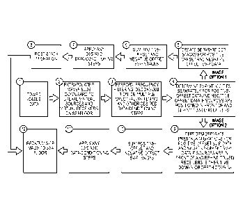
explosive sources, such as vertical vibrators and vertical-impact sources) may
be used to
construct S-mode images, such as SV and SH images. The advantages of non-
explosive
sources include that they are acceptable sources in environments where
explosive sources
are prohibited or impractical. Exemplary advantages include:
= Explosives cannot be used in urban environments. In contrast, vibrators
can
operate down streets, alleys, and in close proximity to buildings.
= Explosives cannot be used along road right-of-ways. County roads and
public highways are popular profile locations for vibrators.
= In areas contaminated by mechanical noise (road traffic, gas-line pumping
stations, oil well pump jacks, active drilling rigs, etc.), the compact
impulsive wavelet (typically spanning only 100 to 200 ms) produced by an
explosive shot can be overwhelmed by short noise bursts from noise sources
local to one or more receiver stations. In contrast, a vibrator creates a
wavelet by inserting a long (10 to 12 seconds) chirp into the Earth in which
frequencies vary with a known time dependence. Unless mechanical noise
has exactly the same frequency variation over a 10-second or 12-second time
duration as does a vibrator chirp signal, the cross correlation procedure used
to identify vibroscis reflection events suppresses the noise. Explosive
sources are less practical than vibrators in high-noise environments.
= Vertical impact sources have appeal because they are lower cost than
explosive sources (and usually lower cost than vibrators). Operators often
choose the lowest cost source even if the source has some technical
shortcomings.
[0137] While non-explosive sources are used in some embodiments described
herein,
explosive sources may be used in other embodiments described herein.
-28-
CA 02866311 2014-09-03
WO 2013/134145 PCT/US2013/028908
[0138] S data can be acquired in the widest possible range of environments
when vertical-
force sources are utilized. Explosive sources can be used in swamps,
mountains, etc. where
non-explosive sources are not feasible or practical, and vibrators and
vertical impact sources
can be used in high-culture areas (cities, roads, etc) where explosives are
prohibited, and
when budget constraints limit source options.
[0139] The systems and methods described with reference to FIGs. 17-20 may
implement
any of the features or principles described with reference to FIGs. 1-16.
Extracting SV Shear Data from P-Wave Seismic Data
[0140] Referring now to FIGs. 21-35, system and methods for extracting SV
shear-wave
data from P-wave seismic data will be described.
[0141] Systems and methods are described for extracting SV shear-wave data
from P-
wave seismic data acquired with a vertical-force source and vertical
geophones. The P-
wave seismic data may comprise legacy P-wave data (e.g., P-wave data acquired
at some
time days, months, or years, such as at least one year, in the past), P-wave
data acquired in
the present day, two dimensional data, three dimensional data, single-
component sensor
data, and/or three-component sensor data acquired across a wide variety of
Earth surface
conditions.
[0142] These systems and methods are based on the use and application of the
SV-P mode
produced by a vertical-force seismic source. The SV component of this seismic
mode
provides valuable rock and fluid information that cannot be extracted from P-
wave seismic
data. The systems and methods may produce an S-wave image from seismic data
acquired
with surface-based vertical geophones.
[0143] According to some embodiments, vertical, single-component or one-
component,
surface-based seismic sensors are used to acquire SV shear data. In some
embodiments,
only a vertical, single-component receiver may be present (or have been
present in the case
of legacy data) at each receiver station.
[0144] Systems and methods are described for extracting SV-SV data from P-wave
seismic data acquired with a vertical-force source and vertical geophones in
situations
where P-wave data are acquired across areas of exposed high-velocity rocks.
-29-
CA 02866311 2014-09-03
WO 2013/134145 PCT/US2013/028908
[0145] Systems and methods are described for extracting P-SV data from P-wave
seismic
data acquired with a vertical-force source and vertical geophones in
situations where P-
wave data are acquired across areas of exposed high-velocity rocks.
[0146] In some embodiments, there is no requirement of any specific
positioning of
receiver relative to source. In some embodiments, the systems and methods
described
herein may apply whether source and receiver are both on the Earth surface, at
the same
elevation, or at distinctly different elevations.
[0147] In some embodiments, upgoing SV events are not used in imaging;
instead, only
the upgoing P part of SV-P data are used in imaging.
[0148] In some embodiments, the sources may have known or predetermined
locations
relative to surface-based receivers and the direction of travel of energy that
reaches the
receivers at their receiver stations may be known before processing of the
received data.
[0149] The principal seismic reflection data that are acquired to evaluate
geological
conditions across onshore areas are compressional-wave (P-wave) data. From a
historical
perspective, numerous large libraries of legacy seismic data exist, with the
ages of these
data extending back into the 1950's and 1960's. Most legacy seismic data are P-
wave data.
[0150] The term "land-based" seismic data refers to any seismic data acquired
in non-
marine environments, which would include data acquired across swamps, marshes,
and
shallow coastal water, as well as data acquired across exposed land surfaces.
Land-based P-
wave data are generated using vertical-force sources. This term -vertical-
force source"
includes any seismic source that applies a vertical force to the Earth.
Included in the broad
range of vertical-force seismic sources are vertical vibrators, vertical
impacts, and shot-hole
explosives.
[0151] P-wave land-based seismic data are recorded using vertical geophones or
other
vertically oriented seismic sensors. When acquiring P-wave seismic data, the
sensor
deployed at each receiver station can be either single-component or three-
component as
long as sensor elements in each receiver package measure vertical movement of
the Earth.
[0152] One or more embodiments described herein may allow SV shear-wave data
to be
extracted from P-wave data acquired with vertical-force sources and vertical
sensors. One
or more embodiments may apply whether a sensor package is single-component or
three-
-30-
CA 02866311 2014-09-03
WO 2013/134145 PCT/US2013/028908
component. One or more embodiments may apply to legacy P-wave seismic data as
well as
to P-wave data acquired in the present day.
[0153] One or more embodiments described herein may allow SV shear-wave data
to be
extracted from either 2D or 3D P-wave data.
SV-to-P Seismic Mode
101541 The embodiments that are configured to extract SV shear-wave data from
P-wave
data use the SV-to-P converted seismic mode. The notation SV-P will be used to
designate
this wave mode. In this notation, the first term identifies the downgoing
seismic wave (SV)
that illuminates geologic targets, and the second term designates the upgoing
reflected wave
(P) from those targets. To maintain consistent notation, standard P-wave data
will be labeled
as P-P data, meaning the downgoing illuminating wavefield is a P-wave, and the
upgoing
reflected wavefield is also a P-wave.
[0155] Raypath diagrams comparing SV-P imaging of subsurface geology and
conventional P-P imaging are illustrated on Figure 21. The bold arrows 2100,
2102 drawn
at the source station 2104 and receiver station 2106 are vertical to
illustrate: (1) the seismic
source applies a vertical force vector to the Earth, and (2) each sensing
geophone is oriented
vertically or otherwise configured to sense or measure vertical movement of
the Earth.
Receiver 2102 may be a vertical geophone, a vertical component of a multi-
component
geophone, or another single- or multi-component geophone configured to sense,
measure or
detect vertical movement of the Earth (e.g., a "54 degree" geometry geophone
or Gal'perin
geophone). As described hereinabove, a vertical-force seismic source produces
not only P
waves but also SV and SH shear waves. Consequently, both downgoing P and
downgoing
SV raypaths are shown propagating away from the vertical-force source station
2104 on
Figure 21. Segments of downgoing and upgoing raypaths are labeled either P or
SV to
indicate the specific wave mode that travels along each segment of each
raypath. Circled
arrows on each raypath segment identify the direction in which the wave mode
acting on
that raypath segment displaces the Earth. The data polarities indicated by
these particle
displacement vectors agree with the polarity conventions defined by Aki and
Richards
(1980).
[0156] "Common-midpoint" imaging may be used to produce P-P stacked images of
the
Earth's subsurface. In a flat-layered Earth, when the velocity of the
downgoing wavefield
that illuminates a geologic target is the same as the velocity of the upgoing
reflected
-31-
CA 02866311 2014-09-03
WO 2013/134145 PCT/US2013/028908
wavefield from that target, as it is for P-P data, the reflection point (image
point) is half way
between the source and the receiver. Therefore, the terms "common midpoint" or
"CMP"
are used to describe this imaging concept.
[0157] When seismic images are made using a downgoing illuminating wavefield
that has
a velocity that differs from the velocity of the upgoing reflected wavefield,
a different
concept called "common-conversion-point" imaging is used to construct stacked
images of
geologic targets. The abbreviation "CCP" is used to indicate this seismic
imaging strategy.
CCP imaging techniques are used to construct stacked images from SV-P data
because the
downgoing SV mode has a velocity that differs from the velocity of the upgoing
P mode
(Fig. 21).
[0158] As shown on Figure 21, the upgoing events that arrive at a receiver
station are P-
wave events for both P-P and SV-P modes. A concept not illustrated in this
simplified,
straight-raypath model is that a P raypath curves to become almost true-
vertical when it
enters an unconsolidated, low-velocity layer 2100 that covers most of the
Earth's surface.
This principle is illustrated on Figure 22. When upgoing P raypaths 2200, 2202
bend to
almost true-vertical as they approach a receiver station 2106, their particle
displacement
vectors 2204, 2206 align with vertically oriented geophones at receiver
station 2106 and
induce a strong response in a vertical geophone. Because both legacy P-wave
seismic data
and present-day P-wave data are recorded with vertical geophones, these P-wave
data
contain not only P-P modes, but also SV-P modes, such as raypath 2200
illustrated in
Figure 22.
[0159] As illustrated in Figure 36, if a P-wave is traveling in a true
horizontal direction
when it arrives at a vertical geophone, the P-wave will not generate any
response in the
geophone. If a P-wave is traveling in a true vertical direction when it
arrives at a vertical
geophone, the P-wave will induce a maximum geophone response (A). At any
intermediate
angle of approach, the geophone response produced by an arriving P-wave will
be A
cos(t), where c1) is the approach angle measured relative to true vertical,
and A is the
maximum response the P-wave produces when it travels in a true vertical
direction. At
some non-vertical approach angle (IN, a P-wave will still have a small
vertical component
that will produce a small response in a vertical geophone, but not a "usable"
signal. The
exact value of cutoff angle (13õ varies from location to location, and varies
day to day at any
given location, depending on the level of background noise that is present.
Background
-32-
CA 02866311 2014-09-03
WO 2013/134145 PCT/US2013/028908
noise includes wind-generated shaking of local vegetation, mechanical
vibrations from
nearby machinery or vehicular traffic, water drops falling from the sky or
dripping from
close-by trees and bushes, and other factors that induce disturbances close to
a geophone
station.
[0160] An additional imaging option is illustrated on Figure 23. In this
scenario, the
raypath labeling acknowledges a vertical-force source 2104 causes an SV-SV
mode 2300
which arrives at a receiver station 2106 just as does a P-P mode 2108 (Figure
21).
However, when the principle is applied that, in most Earth surface conditions,
raypaths
approach a surface receiver in an almost or substantially vertical direction,
the orientation of
the particle displacement vector 2302 associated with an upgoing SV raypath
2301 does not
activate a vertical geophone (as the upgoing P waves do in Figure 22). Thus
for some P-
wave data acquired with vertical geophones, it may not be possible to extract
SV-SV
reflection events (or P-SV reflection events) from the response of vertical-
geophone data.
[0161] An exception to the principle described on Figure 23 occurs when
vertical
geophones are deployed across an Earth surface where the top Earth layer is a
hard, high-
velocity material, as in layer 2400 in Figure 24. In this type of surface
condition, an SV
raypath 2400 will arrive at a receiver station 2106 along a substantially
nonvertical
trajectory, and the vertical component of an SV particle displacement vector
2402 will
activate a vertical geophone 2106 (Figure 24). Thus, when P-wave data are
acquired across
high-velocity surfaces with vertical geophones, data having an upgoing SV mode
are
recorded by vertical geophones in addition to SV-P data. As a result, both P-
SV and SV-SV
data, which both have upgoing SV modes, are recorded by vertical geophones in
situations
where geophones are deployed across a high-velocity surface layer. Both
upgoing P and SV
raypaths in Figures 24 approach receiver station 2106 from a direction that
differs
significantly from near-vertical.
[0162] As illustrated in Figure 37, where the upgoing mode is SV, the response
that an SV
arrival induces in a vertical geophone is Asin(0), rather than Acos(0) as it
is for an
upgoing P mode. The larger 0 is, the stronger the SV response is. As S
velocity increases in
the top-most Earth layer, 0 increases. How big 0 should be, and how large S
velocity
should be to ensure there is an appreciable value of (I), depend again on the
magnitude of
the background noise at the receiver station.
-33-
CA 02866311 2014-09-03
WO 2013/134145 PCT/US2013/028908
[0163] One or more embodiments described herein may acquire P-SV data without
the
use of three-component geophones and without extracting the upgoing SV mode
from
horizontal-geophone responses. One or more embodiments described herein allows
P-SV
data to be acquired with single-component vertical geophones, for example in
situations
where the top Earth layer is high-velocity rock. One or more embodiments
described herein
may acquire P-SV data without the use of a receiver configured to sense,
detect or measure
horizontal movement of the Earth.
[0164] P-SV and SV-P raypaths are compared on Figure 25. Because upgoing
raypaths
become near-vertical in a low-velocity surface layer (Fig. 22), the
orientation of particle
displacement associated with the upgoing SV segment 2500 of a P-SV mode 2502
fails to
activate a vertical geophone in many Earth surface environments. Thus, in some
vertical-
geophone P-wave data, there will be no usable P-SV data. However, P-SV data
will be
recorded by a vertical geophone in cases where the top Earth layer has high
velocity (Figure
24).
SV-P Image Space
[0165] The imaging principles of P-SV and SV-P modes 2502, 2504 illustrated on
Figure
25 emphasize an SV-P mode images geology 2506 closer to a source station 2508
than to a
receiver station 2510. When P-wave data are acquired with a source-receiver
geometry in
which receivers occupy an area that differs significantly from the area
occupied by sources,
it is useful to understand how the image space spanned by SV-P data differs
from the image
space spanned by the P-SV mode.
[0166] Figures 26A and 26B show two options in which P-wave data are acquired
across
the same image space using vertical-force sources and vertical geophones. The
figures
illustrate source-receiver geometries from an aerial view looking downward,
showing the
size and position of SV-P image space (IL 12, 13, 14) for two three-
dimensional P-wave
data-acquisition geometries. With the source-receiver geometry shown on Figure
26A, the
area spanned by source stations 2600 is larger than the area spanned by
receiver stations
2602. In the option shown as Figure 26B, the reverse is true, and receivers
span an area
2604 larger than the area spanned by sources 2610. The CMP P-wave image space
will be
the same for both geometries because the same number of source-receiver pairs
is involved,
and these station pairs occupy the same Earth coordinates in both geometries.
To avoid
graphic clutter, the boundaries of P-P image space are not shown on the
drawings, but if
-34-
CA 02866311 2014-09-03
WO 2013/134145 PCT/US2013/028908
drawn, the boundaries of P-P image space would be half-way between the
boundaries of
receiver area R1-to-R4 and the boundaries of source area S 1 -to-S4 in both
Figures 26A and
26B, reflecting the midpoint aspect of the CMP method.
[0167] The size and position of SV-P image space resulting from these two
distinct data-
acquisition geometries of Figures 26A and 26B differ. SV-P image space covers
a large
area 2608 when the geometry option of Figure 26A is used and a relatively
smaller area
2606 when the geometry option of Figure 26B is used. For both geometries, SV-P
image
points are positioned closer to source stations than to receiver stations.
Because of the
reciprocal relationships between the image coordinates of SV-P and P-SV modes
(Figure
25), the image space spanned by P-SV data when the geometry of Figure 26A is
used would
be the image space spanned by SV-P data in Figure 26B. If the geometry of
Figure 26B is
used, then P-SV data would span the SV-P image space drawn on Figure 26A.
Because the
same number of source-receiver pairs is involved in each data-acquisition
geometry in this
exemplary embodiment, SV-P stacking fold across the larger area (Fig. 26A)
will be lower
than SV-P stacking fold across the smaller area (Fig. 26B). Each geometry
offers
advantages for the SV-P mode, depending on the signal-to-noise ratio of SV-P
data. If the
SV-P signal-to-noise ratio is rather high, then the option of Figure 26A
extends good-
quality SV information over a larger area than what is imaged by P-SV data. If
the SV-P
signal-to-noise ratio is low, then increasing SV-P fold over a smaller area as
in Figure 26B
should create better quality SV information than what is provided by P-SV data
that extend
over a larger area with reduced fold.
SV-P Data Processing ¨ Data Polarity
[0168] As explained with reference to the embodiments of Figures 1-20, to
extract SV-
SV and SH-SH modes from data generated by a vertical-force source, the
processing
reverses the polarity of data acquired by horizontal geophones stationed in
the negative-
offset direction relative to the polarity of data acquired by horizontal
geophones deployed in
the positive-offset direction. That data polarity adjustment does not apply to
SV-P data in
this embodiment because the SV-P wave mode is recorded by vertical geophones,
not by
horizontal geophones.
[0169] Raypaths involved in positive-offset and negative-offset SV-P imaging
are
illustrated on Figure 27. In this diagram, SV-P data generated at vertical
source A and
recorded at vertical receiver A are labeled SVA for the downgoing SV mode and
PA for the
-35-
CA 02866311 2014-09-03
WO 2013/134145 PCT/US2013/028908
upgoing P mode. The offset direction from vertical source A to vertical
receiver A is
arbitrarily defined as positive offset. When the positions of source and
receiver are
exchanged, creating vertical source B and vertical receiver B, the offset
direction reverses
and is defined as negative offset. The raypath for negative-offset SV-P data
is labeled SVB
for the downgoing SV mode and PEI for the upgoing P mode. The polarities shown
for the
downgoing SV particle-displacement vector conform to the polarity convention
established
by Aki and Richards (1980) and documented by Hardage et al. (2011). Note that
for both
positive-offset data and negative-offset data, the vertical component of the
particle-
displacement vectors for the upgoing P modes are in the same direction
(pointing up), hence
there is no change in SV-P data polarity between positive-offset data and
negative-offset
data.
101101 If the SV-SV mode is extracted from P-wave data in situations where a
high-
velocity Earth surface allows the upward traveling SV mode to energize a
vertical geophone
(Fig. 24), it likewise is not necessary to adjust the polarity of the vertical-
geophone data in
either offset-direction domain. Adjusting the polarity of upward traveling SV
modes in the
negative-offset domain to agree with the polarity in the positive-offset
domain is used when
the SV mode is recorded by horizontal geophones, not when they are acquired by
vertical
geophones.
SV-P Data Processing - Velocity Analysis
101711 The embodiments described herein may be configured to perform a
velocity
analysis as a data-processing step when constructing seismic images. When CMP
data are
processed, it is not necessary to be concerned about which offset domain
(positive or
negative) data reside in when performing velocity analyses. If the velocities
of downgoing
and upgoing wave modes are the same (CMP data processing), the same velocity
behavior
occurs in both offset directions. However, when converted modes are involved,
the method
may comprise two velocity analyses¨one analysis for positive-offset data and a
second
analysis for negative-offset data.
101121 The reason for this dual-domain velocity analysis is illustrated on
Figure 27, which
shows two distinct rock facies between two surface-based source and receiver
stations.
Laterally varying rock conditions such as shown on this diagram can be found
in many
areas. For purposes of illustration, assume the P and S velocities in Facies A
are
significantly different from the P and S velocities in Facies B. The travel
time required for
-36-
CA 02866311 2014-09-03
WO 2013/134145 PCT/US2013/028908
a positive-offset SV-P event to travel raypath SVA-PA is not the same as the
travel time for a
negative-offset SV-P event to travel raypath SVB-PB. This difference in travel
time occurs
because the SVA mode is totally in Facies A, but the SVB mode is almost
entirely in Facies
B. Likewise, all of mode Pg is in Facies A, but mode PA has significant travel
paths inside
Facies A and Facies B. Because travel times differ in positive-offset and
negative-offset
directions, one velocity analysis is done on positive-offset data, and a
separate velocity
analysis is done for negative-offset data.
[0173] Examples of SV-P reflection events extracted from P-wave data by
velocity
analysis are displayed as Figures 28A and 28B. Figures 28A and 28B illustrate
SV-P
reflections extracted from vertical-geophone P-wave seismic data. The seismic
source was
a shot-hole explosive (a vertical-force source). Two shot signal gathers or
acquisitions
generated at source stations 1007 and 1107 are displayed after velocity
filtering. For each
shot gather, velocity analyses were done separately for positive-offset data
and negative-
offset data. In these examples, there is not a large difference between
positive-offset and
negative-offset velocities. As a result, the curvatures of negative-offset SV-
P reflections are
approximately the same as the curvatures of positive-offset SV-P reflections.
[0174] Only reflection events having curvatures coinciding with downgoing Vs
velocities
and upgoing Vp velocities appropriate for the rock sequence where these data
were acquired
are accepted. Other velocities are rejected. These examples come from a
seismic survey for
which the energy sources were vertical-force sources, and the analyzed data
were recorded
by vertical geophones. Analyses for two common-shot trace gathers are shown.
For each
shot gather, positive-offset data were subjected to velocity analysis
separately from
negative-offset data. Each velocity analysis rejected reflection events having
velocities that
differed by more than 20-percent from the velocities used to create high-
quality P-SV
images across the same image space. The result is that high-quality SV-P
reflections are
extracted from vertical geophone data for both positive-offset P-wave data and
negative-
offset P-wave data. The principal difference in P-SV and SV-P velocity
analyses in this
exemplary embodiment is that P-SV velocity analyses are done on data recorded
by
horizontal geophones; whereas, SV-P velocity analyses are done on data
recorded by
vertical geophones.
[0175] To make seismic images from the reflection events shown in FIGs. 28A
and 28B,
reflection events for a number of source stations in the survey (e.g., at
least 10, at least 100,
-37-
CA 02866311 2014-09-03
WO 2013/134145
PCT/US2013/028908
at least 1000, etc.) would be generated. The reflection event data then would
be binned,
stacked and migrated. For example, the reflection event data may be binned
using CCP or
ACP binning strategies to define those coordinates. The reflection event data
may then be
stacked and then migrated after stack to generate an image. Migration
physically moves
reflections from where they are in reflection time to where they should be in
image time.
[0176] The reflection events shown in FIGs. 28A and 28B comprise primary
reflection
events and multiple reflection events. Multiple reflection events result from
multiple
reflections of seismic waves caused by reverberations between interfaces of
layers of the
Earth. Multiple reflection events can cause an image to not be positioned
correctly in travel
time space. Multiple reflections may be filtered out of the reflection events
in subsequent
processing.
[0177] The reflection events shown in FIGs. 28A and 28B comprise an
interpreted
primary reflection at a point where reflection events in negative offset and
positive offset
domains meet, such as point 2800. The reflection events comprise an
interpreted multiple
reflection at a point where reflection events in negative offset and positive
offset domains
do not meet, such as point 2802.
SV-P Data Processing: Constructing SV-P Images
[0178] The processing of SV-P data for generating images can be done in a
number of
ways, such as: (1) by CCP binning and stacking of SV-P reflections, followed
by post-stack
migration of the stacked data, or (2) by implementing prestack time migration,
depth
migration or reverse-time migration of SV-P reflections. Each method has its
own benefits.
For example, method 2 (prestack migration) is a more rigorous approach; method
1 (CCP
binning/stacking and post-stack migration) is lower cost. To perform CCP
binning and
migration of SV-P data, CCP coordinates of SV-P image points are mirror images
of CCP
image points associated with P-SV data, as illustrated on Figure 29. The SV-P
data-
processing strategy may be based on this mirror-image symmetry of CCP image-
point
profiles for P-SV and SV-P modes.
[0179] Because positive-offset and negative-offset SV-P data have different
velocity
behaviors, two separate CCP binning/stacking steps are done to create an SV-P
stacked
image. In a first step, positive-offset data are binned and stacked into an
image using
velocities determined from positive-offset data, and in a second step,
negative-offset data
are binned and stacked into a second image using velocities determined from
negative-
-38-
CA 02866311 2014-09-03
WO 2013/134145 PCT/US2013/028908
offset data. The final SV-P image is the sum of these two images. This same
dual-image
strategy may be implemented when binning and stacking P-SV data. The three
stacked
images (negative-offset image, positive-offset image, and summed image) can be
migrated
and used in geological applications. As documented by Hardage et al. (2011)
relative to P-
SV imaging, some geologic features are sometimes better seen in one of these
three images
than in its two companion images. Thus all three stacked and migrated images
may be used
in geological interpretations.
SV-P Data Processing: Method 1¨CCP Binning, Stacking, and Post-Stack Migration
[0180] Some commercial seismic data-processing software that can be purchased
or
leased by the geophysical community can calculate converted-mode image
coordinates
called asymptotic conversion points, which are abbreviated as ACP. Two
examples are
Vista seismic data processing software, sold by Geophysical Exploration &
Development
Corporation, Alberta, Canada and ProMAX seismic data processing software, sold
by
Halliburton Company, Houston, Texas. An ACP is an image coordinate where the
trend of
correct CCP image points for a specific source-receiver pair becomes quasi-
vertical (Figure
29). Deep geology is correctly imaged using P-SV data binned using ACP
coordinates, and
would also be correctly imaged by SV-P data binned using ACP concepts that are
adjusted
for SV-P data. However, shallow geology is not correctly imaged for either P-
SV data or
SV-P data when ACP binning methods are used. True CCP binning can produce
correct
stacked images of both shallow and deep geology for converted modes
appropriate for post-
stack migration. On Figure 29, the asymptotic conversion point for the P-SV
mode is
labeled ACP1, and the asymptotic conversion point for the SV-P mode is labeled
ACP2.
Neither image point is correct except where their associated CCP binning
profile is quasi-
vertical (i.e., for deep targets). As emphasized above, these two image points
are mirror
images of each other relative to the common midpoint (point CMP on Figure 29)
for any
source-receiver pair involved in a seismic survey.
[0181] One exemplary method of producing SV-P CCP/ACP binning comprises
adjusting
software that performs CCP binning for P-SV data so that the coordinates of
sources and
receivers are exchanged when determining image-point coordinates. Referring to
the
source-receiver pair drawn on Figure 29, an exchange of station coordinates
has the effect
of moving the receiver station to the source station and the source station to
the receiver
station. Software used to process P-SV data will then calculate the image
point trend
-39-
CA 02866311 2014-09-03
WO 2013/134145
PCT/US2013/028908
labeled CCP2 rather than the trend labeled CCP1. Using coordinates specified
by profile
CCP2 to bin SV-P reflections extracted from vertical-geophone data can produce
SV-P
images. The SV-P images should be equal in quality to what is now achieved
with P-SV
data.
[0182] Curve CCP1 shows the trend of common-conversion points for P-SV data.
Curve
CCP2 shows the trend of common-conversion points for SV-P data. ACP1 and ACP2
are
asymptotic conversion points for trends CCP1 and CCP2, respectively. CCP1 and
CCP2
are mirror images of each other relative to the common midpoint CMP for this
source-
receiver pair.
SV-P Data Processing: Method 2¨Prestack Migration
[0183] According to an alternative embodiment, prestack migration can be done
so as to
create a time-based seismic image or a depth-based seismic image. Referring to
Figure 30,
prestack migration may be done by numerically propagating a specific seismic
wavefield
downward from each source station to illuminate geologic targets, and then
numerically
propagating a specific seismic wavefield upward from reflecting interfaces to
each receiver
station.
[0184] The specific wavefields used in prestack time migration, depth
migration, or
reverse-time migration may be created by applying velocity filters to data
recorded by
vertical geophoncs so that reflection events having only a predetermined
velocity behavior
remain after velocity filtering. The predetermined velocity behaviors of
interest are those
associated with the following seismic modes: P-P, P-SV, SV-SV, and SV-P. If 3C
geophones are used in combination with a vertical-force source, a fifth
velocity filtering
option is to extract SH-SH reflection events. However, for this latter option,
the filtering
action is applied to data recorded by transverse horizontal geophones. The
result is an
image of geologic interfaces seen by each specific seismic mode. For
simplicity, only one
source station and only one receiver station are shown on Figure 30.
[0185] The table on Figure 30 considers only wave modes produced by a vertical-
force
source as described hereinabove with reference to Figures 1-20 (P, SV, SH) and
the
responses of only vertical geophones. For an Earth with isotropic velocity
layers, there are
five possible combinations of downgoing (D) and upgoing (U) modes. These
possibilities
are labeled Option 1 through Option 5 in the figure table.
-40-
CA 02866311 2014-09-03
WO 2013/134145 PCT/US2013/028908
[0186] As indicated by the table on Figure 30, prestack migration software can
create an
SV-P image if the velocity of the downgoing wavefield is that for a
propagating SV
wavefield and the velocity of the upgoing wavefield is that for a P wavefield.
Examples of
SV-P data that would be used for pre-stack migration Option 3 listed on Figure
30 (SV-P
imaging) are exhibited on Figure 28. For a 3D P-wave seismic survey, velocity
filtering
similar to that done to produce these two example shot-gathers would be done
for all shot
gathers across a survey area. If a survey involves 1000 source stations, then
1000 velocity-
filtered shot-gathers similar to those on Figure 28 would be created. All 1000
sets of SV-P
reflections would be pre-stack migrated downward through an Earth model having
layers of
SV velocities and then migrated upward through an Earth model having layers of
P-wave
velocities.
[0187] In Figure 30, a time-space distribution of velocities for a specific
seismic mode is
defined so that a specific downgoing wavefield (D) can be propagated through
this Earth
velocity model from every source station to illuminate targets. A second time-
space
distribution of velocities for a second specific seismic mode is then imposed
to propagate
that specific reflected upgoing wavefield (U) to every receiver station. The
combinations of
downgoing and upgoing velocities that can be implemented for a vertical-force
source and
vertical geophones are listed in the table of Figure 30.
SV-P Data Processing - Determining S-Wave Velocity
[0188] To calculate either of the CCP binning profiles shown on Figure 29, the
processing
system is configured to determine the S-wave velocity within the geology that
is being
imaged. If the alternate option of creating converted-mode images with
prestack migration
techniques is used (Fig. 30), the processing system is configured to generate
reliable
estimates of S-wave velocities within the rocks that are illuminated by the
seismic data.
Determining the S-wave velocity for calculating SV-P image points can be done
in the same
way that S-wave imaging velocities are determined for P-SV data. Methods for
determining
S-wave velocity for calculating converted-mode image points comprise:
1. Use 3-component vertical seismic profile (VSP) data acquired local to
the
seismic image area to calculate interval values of Vp and Vs velocities.
2. Use dipole sonic log data acquired local to the seismic image space to
determine Vp and Vs velocities.
-41-
CA 02866311 2014-09-03
WO 2013/134145 PCT/US2013/028908
3. Combine laboratory measurements of VpNs velocity ratios for rock types
like those being imaged with seismic-based estimates of P-wave velocities to
calculate S-wave velocities.
4. Calculate CCP binning profiles for a variety of VpNs velocity ratios,
make
separate stacks of converted-mode data for each CCP trend, and examine the
series of stacked data to determine which CCP profile produces the best
quality image.
[0189] Any of these methods will provide reliable S-wave velocities to use for
binning
SV-P data. Alternate methods may be used.
Comparison of SV-P data to P-SV data
[0190] This application shows there are several similarities between SV-P data
and P-SV
data, according to some exemplary embodiments. There are also differences
between the
two wave modes, according to some exemplary embodiments. Some of these
similarities
and differences are listed in the table shown as Figure 31. Similarities
between SV-P and P-
SV data include items 1, 5, and 6 (same energy source, same velocity analysis
strategy, and
same normal moveout (NMO) velocity behavior). Differences include items 2, 3,
4, and 7
(different receivers, different image coordinates, different CCP profiles, and
different
polarity behavior).
SV-P Data Processing Apparatus
101911 Referring now to FIG. 32, a data processing system for processing SV-P
data will
be described. System 3200 is configured to extract SV shear data from vertical-
sensor
responses. System 3200 comprises a digital computation system 3202, such as a
personal
computer, UNIX server, single workstation, high-end cluster of workstations,
or other
computing system or systems. System 3202 comprises sufficient processing power
to
process large quantities of complex seismic data. A mass storage device 3204
or other
memory is coupled to digital computation system 3202, which is configured to
receive data
from the field recorders or sensors stored on a digital media 3202, such as a
memory card,
hard drive, or other memory device. Mass storage device 3204 is configured to
download
or receive the multi-component seismic data from digital media 3206 and to
store the data in
a database.
[0192] In this embodiment, digital media 3206 comprises data received from a
vertical
sensor using a field recorder or receiver. The data on digital media 3206 may
have been
-42-
CA 02866311 2014-09-03
WO 2013/134145 PCT/US2013/028908
acquired recently or days, months, or years in the past. The data may have
been recorded
using a vertical force sensor having a sufficient listening time, for example
of at least 5
seconds, at least 8 seconds, at least 10 seconds, or other periods of time.
The data may have
been acquired without the expectation of recovering SV-P data by the entity
handling the
acquisition of data and without knowledge of the presence of SV-P data in the
data acquired
from seismic reflections.
[0193] The remaining elements in FIG. 32 may comprise any of the embodiments
described hereinabove with reference to FIG. 19, or other components. Software
library
3212 may comprise processing algorithms configured to process the data
according to any
of the principles described hereinabove, for example with reference to FIGs.
21-31, and
FIGs. 34 and 35 below.
SV-P Data Acquisition
[0194] Referring now to Figure 33, a diagram of a data acquisition system 3300
and
method for acquiring SV-P data from a vertical-force source using surface-
based sensors
will be described. A vertical-force seismic source 3302 is disposed on, near,
or within a
shallow recess of the Earth's surface 3304, which may comprise relatively high-
velocity
layers or portions or relatively low-velocity layers or portions. Source 3302
is configured to
impart a vertical-force to surface 3304 to provide seismic waves into Earth
media 3306.
Source 3302 may comprise a vertical vibrator, shot-hole explosive, vertical-
impactor, air
gun, vertical weight-dropper or thumper, and/or other vertical-force sources.
In this
example, vertical-force source 3302 produces compressional P mode and both
fundamental
shear modes (SH and SV) in Earth 3306 directly at a point of application 3308
of the
vertical-force source. In this embodiment, at least some of the SH and SV
shear waves are
generated at source 3302 and not by subsurface conversion caused by portions
of Earth
media 3306. The frequency waves may be provided in a frequency sweep or a
single
broadband impulse. A vertical-force source may be used without any horizontal-
force
sources.
101951 A seismic sensor 3310 is along the Earth's surface, which may include
being
disposed on, near, or within a recess of the Earth's surface 3304. For
example, in one
embodiment, shallow holes may be drilled and sensors 3310 deployed in the
holes to avoid
wind noise, noise produced by rain showers, etc. Sensor 3310 is configured to
detect or
sense upgoing wave modes, reflected from subsurface sectors, formations,
targets of
-43-
CA 02866311 2014-09-03
WO 2013/134145 PCT/US2013/028908
interest, etc. In this embodiment, sensor 3310 may comprise a vertical-
response sensor
(either single-component or 3-component package) configured to sense
compressional P
modes and, as described herein, other modes such as SV-P (e.g., direct SV-P).
In one
embodiment, sensor 3310 may comprise a vertical-response sensor without
horizontal-
response sensors, for example only a single, vertical-response sensor. Various
arrays and
configurations of sources 3302 and sensors 3310 may be implemented in
different
embodiments.
[0196] The remaining elements in FIG. 32 may comprise any of the embodiments
described hereinabove with reference to FIG. 17, or other components.
Data Processing in Low-Velocity Earth Surface
[0197] Referring now to FIG. 34, a flow diagram illustrating a method 3400 of
processing
vertical sensor data for low-velocity Earth surface will be described. The
method may be
operable on one or more processing circuits, such as digital computation
system 3202. The
method 3400 may use similar techniques to those described above with reference
to FIG.
20, which contains further explanation of some of the processing procedures
described in
FIG. 34. At a block 3402, a processing circuit is provided with mixed P-P and
SV-P modes
in vertical-sensor data from acquisition steps described previously. At block
3404, the
processing circuit is configured to or programmed to segregate, separate or
otherwise
remove P-P and SV-P mode data by applying velocity filters to reject or filter
out improper
wave-mode propagation velocities.
[0198] At a block 3406, the processing circuit is configured to determine NMO,
stacking
and/or migration velocities for P-P and SV-P modes. Separate velocity analyses
should be
done for positive-offset SV-P data and for negative offset SV-P data. The
processing circuit
performs separately velocity analyses for positive-offset data and negative-
offset data to
determine how the magnitudes of interval velocities differ in these two offset
domains. If
there is no lateral variation in P and SV velocities around a source station,
there is no need
to do two separate SV-P velocity analyses ¨ one velocity analysis for positive-
offset data,
and a second velocity for negative-offset data. In such a simple, uniform-
velocity Earth,
positive-offset SV-P reflections and negative-offset SV-P reflections have the
same velocity
curvatures, and a velocity analysis done in one offset domain can be used for
the opposite-
azimuth offset domain. However, it is rare for there to not be lateral
variations in P and SV
velocities around a source station as illustrated on Figure 27. When layer
velocities vary
-44-
CA 02866311 2014-09-03
WO 2013/134145 PCT/US2013/028908
laterally for any reason, positive-offset and negative-offset SV-P data should
undergo
separate velocity analyses as previously discussed using Figure 27. To ensure
lateral
velocity variations are accounted for, converted-mode data are processed as
two separate
data sets. One data set involves only positive-offset data, and the second
data set involves
only negative-offset data. Velocity filtering may be done separately for
positive-offset data
and negative-offset data to determine offset dependent interval velocities
that can be used to
image SV-P data. Velocity filtering may be done separately for positive-offset
data and
negative-offset data to output SV-P reflection data corresponding to the
calculated SV-P
velocities. The velocities used in some embodiments are the magnitudes of
interval
velocities and average velocities needed to stack and/or migrate SV-P data.
These
velocities may have no algebraic sign.
[0199] At a block 3408, static corrections are applied to improve reflector
alignment.
These corrections involve time shifts of data acquired at each source and
receiver station.
Because these time shifts are applied to an entire data trace, they are termed
static
corrections to differentiate them from dynamic time adjustments done by other
processes.
One static correction removes timing differences caused by variations in
station elevations
by adjusting time-zero on each data trace to mathematically move all source
and receiver
stations to a common datum plane. A second static correction removes timing
differences
cause by different velocities being local to different source and receiver
stations. The end
result of these static corrections is an improvement in reflection continuity.
102001 At a block 3410, any one of many noise rejection procedures may be
applied to the
data to improve the signal-to-noise ratio. Some noise rejection options may be
simple
frequency filters. Others may be more sophisticated tau-p, f-k, or
deconvolution
procedures. At block 3410, multiple attenuation may be applied to attenuate
noise
attributable to multiples.
[0201] As described, multiple methods are available for processing the data to
identify
SV-P mode data and use it for generating an image, such as Method 1 and Method
2
described above. If Method 1 is used, at a block 3412, the processing circuit
is configured
to stack (or sum) P-P, SV-P positive-offset and SV-P negative-offset data
separately using
either CCP coordinates or ACP coordinates. At a block 3414, the processing
circuit is
configured to sum SV-P positive-offset and SV-P negative offset stacks. Block
3414 may
use a CCP binning process. At a block 3416, the processing circuit is
configured to migrate
-45-
CA 02866311 2014-09-03
WO 2013/134145 PCT/US2013/028908
post-stack data to make four images: a P-P image, an SV-P positive offset
image, an SV-P
negative-offset image and an SV-P summed image.
[0202] If Method 2 is used, at a block 3420, the processing circuit is
configured to do
separate pre-stack time migrations, depth migrations, or reverse-time
migrations of P-P, SV-
P positive offset data and SV-P negative-offset data and, at a block 3422, sum
SV-P
positive-offset and SV-P negative-offset images.
[0203] At block 3418, an operator views the images created by either or both
of Method 1
and Method 2 and makes a determination as to whether the image quality is
acceptable. If
not, the process returns, for example to block 3406 for further processing. An
operator may
adjust static corrections, recalculate velocities, etc. Alternatively, block
3418 may be
automated to not require a person to make the determination, but rather to
have the
processing circuit make the determination based on certain image goals.
Data Processing in High-Velocity Earth Surface
[0204] Referring now to FIG. 35, a flow diagram illustrating a method 3500 of
processing
vertical sensor data for high-velocity Earth surface will be described. The
method 3500
may use similar techniques to those described above with reference to FIGs. 20
and 34,
which contains further explanation of some of the processing procedures
described in FIG.
35. As explained previously, in high-velocity Earth surface situations,
upgoing SV data can
be detected by a vertical-force source, meaning that the data that can be
processed into
images now includes the SV-SV mode and the P-SV mode.
102051 At a block 3502, a processing circuit is provided with mixed P-P, SV-
SV, P-SV
and SV-P modes in vertical-sensor data from acquisition steps described
previously. At
block 3504, the processing circuit is configured to or programmed to
segregate, separate or
otherwise remove P-P, SV-SV, P-SV and SV-P mode data by applying velocity
filters to
reject or filter out improper wave-mode propagation velocities.
[0206] At a block 3506, the processing circuit is configured to determine NMO,
stacking
and/or migration velocities for P-P, SV-SV, P-SV and SV-P modes. Separate
velocity
analyses are required for positive-offset P-SV and SV-P data and for negative
offset P-SV
and SV-P data.
[0207] At a block 3508, static corrections are applied to improve reflector
alignment, as
described with reference to block 3408. At a block 3510, any one of many noise
rejection
-46-
CA 02866311 2014-09-03
WO 2013/134145 PCT/US2013/028908
procedures may be applied to the data to improve the signal-to-noise ratio.
Some noise
rejection options may be simple frequency filters. Others may be more
sophisticated tau-p,
f-k, or deconvolution procedures. At block 3510, multiple attenuation may be
applied to
reduce noise attributable to multiples.
[0208] As described, multiple methods are available for processing the data to
identify
SV-P mode data and use it for generating an image, such as Method 1 and Method
2
described above. If Method 1 is used, at a block 3512, the processing circuit
is configured
to stack (or sum) P-P, SV-P positive-offset and SV-P negative-offset data and
P-SV
positive-offset data and P-SV negative-offset data, each to be stacked
separately. At a block
3514, the processing circuit is configured to sum SV-P positive-offset and SV-
P negative
offset stacks and separately sum P-SV positive-offset and P-SV negative-offset
stacks. At a
block 3516, the processing circuit is configured to migrate post-stack data to
make eight
images: a P-P image, an SV-P positive offset image, an SV-P negative-offset
image, an SV-
SV image, a P-SV positive offset image, a P-SV negative offset image, P-SV
summed
image and an SV-P summed image.
[0209] If Method 2 is used, at a block 3520, the processing circuit is
configured to do
separate pre-stack time migrations, depth migrations, or reverse-time
migrations of P-P, SV-
SV, SV-P and P-SV positive offset data and SV-P and P-SV negative-offset data
and, at a
block 3522, sum SV-P positive-offset and SV-P negative-offset images.
[0210] At block 3518, an operator views the images created by either or both
of Method 1
and Method 2 and makes a determination as to whether the image quality is
acceptable. If
not, the process returns, for example to block 3506 for further processing. An
operator may
adjust static corrections, recalculate velocities, etc. Alternatively, block
3518 may be
automated to not require a person to make the determination, but rather to
have the
processing circuit make the determination based on certain image goals.
[0211] As illustrated in a comparison of Figures 20, 34 and 35, it is not
necessary in the
methods of Figures 34 and 35 to change the polarity of negative-azimuth SV-P
data to agree
with the polarity of positive-azimuth SV-P data when dealing with vertical-
sensor data.
Also, two separate velocity analyses are performed when processing SV-P data
as in the
methods of Figures 34 and 35 because that imaging is based on common-
conversion point
concepts, not on common-midpoint concepts as used in the methods of Figure 20.
In the
methods of Figures 34 and 35, one velocity analysis is done for positive-
azimuth data and a
-47-
CA 02866311 2014-09-03
WO 2013/134145 PCT/US2013/028908
second analysis is done for negative-azimuth data (as explained with reference
to Figure
27).
Extracting Shear Wave Information from Towed Cable Marine Seismic Data
[0212] According to one or more embodiments, S-wave information can be
extracted
from towed-cable marine data when certain data-processing steps are
implemented by a data
processor.
[0213] In some embodiments, a single-component compressional P wave sensor is
used as
a receiver to receive both P-P and SV-P modes.
[0214] In some embodiments, multi-component sensors are not needed.
[0215] In some embodiments, the single-component compressional P wave sensor
is
disposed in the water well above the sea floor, within the water column, for
example being
towed behind a boat. The single-component compressional P wave sensor may be
similarly
disposed. In some embodiments, neither the P wave source nor P wave receiver
are
disposed on, in contact with, or within the seafloor.
[0216] In some embodiments, an SV-P mode is sensed in a marine environment and
processed to generate a visual image of one or more formations beneath the sea
floor.
[0217] In some embodiments, a virtual source and/or virtual receiver are used
in the
acquisition of the seismic data, wherein the virtual source or receiver is
computationally
derived from data from an actual source or receiver, respectively.
[0218] In some embodiments, a single-component or one-component P wave source
towed by a boat generates a downgoing P wave which upon contact with the
seafloor
generates a downgoing S V shear wave mode directly at the point of contact of
the P wave
with the seafloor, at the seafloor surface. In some embodiments, this
downgoing SV mode
is not a converted shear mode created by reflections of a downgoing P mode off
formations
below the sea floor, but is instead an SV mode generated directly at the point
of contact of
the P wave with the seafloor.
[0219] In some embodiments, image processing is based on towed-cable marine
data in
which there are no receivers other than those in the towed cable.
-48-
CA 02866311 2014-09-03
WO 2013/134145 PCT/US2013/028908
Marine Seismic Sources
[0220] Marine seismic data are generated by towing a seismic source below the
sea
surface. Although some seismic sources, primarily shear-wave generators, have
been
devised that function on the seafloor, seafloor-positioned sources are
generally not used to
generate seismic reflection data because of deployment challenges and
environmental
regulations that protect seafloor biota. Thus, marine seismic data acquisition
typically
involves sources that can be towed at a desired depth below the sea surface
(e.g., 3 to 15
meters or other depths).
[0221] One energy source that may be used in marine environments is a towed
air gun.
Air gun sources can be a single air gun, an array of air guns, or several
arrays of air guns
with each array containing numerous air guns. Sources other than air guns can
be
encountered when legacy marine data are considered. Among source types that
may be used
to acquire marine seismic data are vibrators, explosives, sparkers, and
various mechanisms
that produce impulsive wavelets in the water column. The embodiments described
herein
may use any types of source, such as towed sources, used to generate marine
seismic
reflection data.
Marine Seismic Sensors
[0222] Marine seismic data may be recorded by towing an array of hydrophones
below
the sea surface. These hydrophones are embedded in one or more long cables
that trail
behind a seismic recording boat. Geophones and/or accelerometers are used in
some towed-
cable systems. Marine seismic data can also be acquired with stationary
sensors placed on
the seafloor. Stationary seafloor sensors typically involve combinations of
hydrophones and
geophones or combinations of hydrophones and accelerometers. The embodiments
described herein may use any type of sensor, such as towed-cable sensors,
whether the
sensors comprise hydrophones, geophones, accelerometers, etc.
Virtual Sources and Receivers
102231 Referring now to FIG. 38, a diagram illustrates exemplary components of
a marine
seismic data-acquisition system and raypaths of compressional (P) and vertical
shear (SV)
seismic modes generated during seismic illumination of sub-seafloor geology. P-
wave
raypaths are shown as solid lines. S-wave raypaths are shown as dashed lines.
A source
3800 is towed by a boat 3802. Only P waves propagate in the water layer
because water has
a shear modulus of zero and cannot support shear-mode propagation. When the
downgoing
-49-
CA 02866311 2014-09-03
WO 2013/134145 PCT/US2013/028908
P mode 3800 produced by a marine energy source impinges on the seafloor 3804
at any
incident angle other than true vertical, two downgoing modes¨a P mode 3806 and
an SV
mode 3808¨are created at the seafloor interface 3804 and continue to propagate
downward
and illuminate sub-seafloor targets, such as target 3812. The downgoing P
raypath 3800 in
the water layer 3812 originates at a real seismic source 3800. The origin
point 3810 of the
downgoing SV raypath at the seafloor is a virtual seismic source. The
acquisition and
processing described herein exploits the downgoing SV mode 3808 produced at
virtual-
source coordinates along seafloor 3804.
[0224] The embodiment of Figure 38 may use any type of towed marine energy
sources,
any type of seismic sensors, and may use sensor stations that are towed in the
water layer
and/or stationary sensors on the seafloor.
[0225] Referring now to Figure 39, a simplified version of the diagram of
Figure 38
illustrates the wave physics of exemplary embodiments.
= A is the real seismic source where a downgoing P wave is generated.
= B is the position of the virtual source on the seafloor where, by
downward
wavefield extrapolation, the downgoing P wave from source A segregates
into downgoing P and SV transmitted wave modes and an upgoing P
reflected mode. The upgoing P reflection from seafloor coordinate 3810 is
not shown.
= C is a reflection point from a sub-seafloor target where the downgoing SV
from virtual source B creates an upgoing P reflection event, as described
herein with reference to, for example, Figures 21 through 25, 27, etc.
= D is the position of a virtual receiver created when the upgoing P
reflection
recorded by towed-sensor E is projected downward to the seafloor by
wavefield extrapolation, as will be described below.
= E is a real, towed receiver that records the upgoing P reflection from
target
point C.
Downward Wavefield Extrapolation
[0226] As illustrated in Figure 39, real source A generates a downgoing P wave
that
reaches the seafloor and creates a virtual source. Any coordinate along a
raypath associated
with a propagating seismic wave mode can be defined as the position of a
virtual source or a
virtual receiver for that wave mode. For this reason, the position of a
virtual source in this
-50-
application may be defined by downward extrapolation of a seismic wavefield
from the position of an
actual towed marine seismic source to a desired source-origin point on or near
the seafloor, and the
position of a virtual sensor may be defined by extrapolating a seismic
wavefield downward from a real
towed seismic receiver to a preferred location for that receiver on or near
the seafloor. For an
explanation of recent virtual source/receiver principles, see, for example,
U.S. Patent No. 7,706,211 to
Bakulin et al. titled "Method of Determining a Seismic Velocity Profile" and
U.S. Patent Application
Publication No. 2010/0139927 published June 10, 2010 to Bakulin et al. titled
"Method of Imaging a
Seismic Source Involving a Virtual Source, Methods of Producing a Hydrocarbon
Fluid, and a Computer
Readable Medium." Similarly, the SV-P wave from virtual source B is received
at point D, which may be a
virtual receiver. Point D becomes a virtual receiver by way of wavefield
extrapolation processing.
Downward wavefield extrapolation may be used to transform data generated by a
real source and
recorded by a real receiver to data equivalent to that generated by a deeper
source and recorded by a
deeper receiver. In this manner, virtual sources and virtual receivers may be
computationally,
numerically, or mathematically created, though in alternative embodiments
other techniques may be
used.
[0227] Downward wavefield extrapolation is used for wave-equation migration
of seismic data,
whether migration is done in the depth domain or in the image-time domain. In
one embodiment,
wavefield extrapolation may be implemented as described in Wapenaar, C.P.A.,
and A. J. Berkhout,
1989, Elastic wavefield extrapolation-redatuming of single and multi-component
seismic data: Elsevier
Science, 468 pages. The principles of wavefield extrapolation and
computational procedures used to
perform the data transformations described in Wapenaar may be used in an
exemplary embodiment.
The processing of waveforms may comprise redatuming sources and receivers, and
redatuming that
applies to S wavefields as well as P wavefields. In another embodiment, the
wavefield extrapolation
process of U.S. Patent No. 7,035,737 to Ren, J., 2006, Method for seismic
wavefield extrapolation, may
be used.. Alternative methods and procedures of wavefield extrapolation may be
used in one or more of
the embodiments described herein, and reference to wavefield extrapolation
herein is not to be
construed as limiting to any particular method or algorithm.
- 51 -
CA 2866311 2019-02-06
CA 02866311 2014-09-03
WO 2013/134145 PCT/US2013/028908
[0228] According to some embodiments, wavefield extrapolation may refer to any
process
by which the downgoing, P-only, wavefield produced by a towed marine seismic
source is
computationally or numerically replaced by downgoing P and SV wavefields
produced by a
virtual source at an interface illuminated by the downgoing, real-source, P-
wavefield.
Wavefield extrapolation may also refer to any process by which the upgoing, P-
only
wavefield received at towed receiver E is computationally replaced by virtual
receiver D on
the seafloor. In one embodiment, the interface where a virtual source should
be
computationally positioned is the seafloor. However, according to an exemplary
embodiment, a virtual source could be computationally positioned below the
seafloor or
even above the seafloor as long as the medium below the source station
physically has, or is
numerically assigned, a non-zero shear modulus that will allow a downgoing SV
mode to
propagate.
102291 Referring to Figure 39, downward wavefield extrapolation is used in
this
embodiment to migrate data generated by real towed-source A and recorded by
real towed-
receiver E downward so that the data are transformed to data that would have
been
generated by virtual-source B on the seafloor and recorded by virtual-receiver
D also on the
seafloor.
Marine Shear Waves
[0230] An example of a P-SV reflection is shown on Figure 38 by the downgoing
P
raypath 3806 from the towed source that converts to an upgoing SV raypath 3816
at
reflection point RP2. Because S-waves cannot propagate in water, this upgoing
SV mode
must be recorded by a multicomponent sensor, preferably a 4-component (4C)
sensor
package that has horizontal geophones or accelerometers and is deployed on the
seafloor at
position 4C3.
[0231] According to one embodiment, a system and method involves acquiring and
processing an SV-P mode in a marine seismic application, which is an event
comprising a
downgoing SV raypath produced at the virtual seafloor source position 3810
that converts to
an upgoing P raypath at reflection point RP1. In Figure 38, the SV-P mode is
illustrated for
example by SV raypath 3808 and P raypath 3814. An SV-P mode is the inverse of
the P-
SV mode utilized by marine geophysicists. Because this upgoing P raypath
extends upward
to towed sensor H1, SV-P data are embedded in conventional towed-cable marine
data (e.g.,
-52-
CA 02866311 2014-09-03
WO 2013/134145 PCT/US2013/028908
legacy data). No seafloor sensor is required to capture SV-P data, although
the technology
applies if seafloor sensors are used rather than towed-cable sensors.
Positive-Offset and Negative-Offset Data
[0232] Raypaths involved in positive-offset and negative-offset marine SV-P
imaging are
illustrated on Figure 40. Vp and Vs velocities in Facies A are different than
they are in
Facies B. Straight raypaths are drawn for simplicity.
[0233] In this diagram, SV-P data generated at virtual source A and recorded
at virtual
receiver A are labeled SVA for the downgoing SV mode and PA for the upgoing P
mode.
The offset direction from virtual source A to virtual receiver A is
arbitrarily defined as
positive offset. When the positions of source and receiver are exchanged,
creating virtual
source B and virtual receiver B, the source-to-receiver offset direction
reverses and is
defined as negative offset. The raypath for negative-offset SV-P data is
labeled SVB for the
downgoing SV mode and Pg for the upgoing P mode. The polarities shown for the
downgoing SV particle-displacement vector conform to the polarity convention
established
by Aki and Richards (1980) and documented by Hardage et al. (2011). Note that
for both
positive-offset data and negative-offset data, the vertical component of the
particle-
displacement vectors for the upgoing P modes are in the same direction
(pointing up), hence
there is no change in SV-P data polarity between positive-offset data and
negative-offset
data.
[0234] The consideration of positive-offset and negative-offset data is used
in land-based
seismic data acquisition where receivers extend in all azimuths away from a
source point.
The possibility of positive-offset and negative-offset data is also considered
for marine
seismic data. Most towed-cable marine seismic data involve only positive-
offset data
because the source is usually positioned in front of the receiver cable (Fig.
41 at (a)).
However, a source could be attached to a separate boat trailing at the rear of
a towed
receiver cable (Fig. 41 at (b)). In such a case, the data would be negative-
offset data. In
modern marine surveys, source boats often precede and trail towed cables as
shown on
Figure 41 at (c), and the recorded data then involve both positive-offset and
negative-offset
data.
SV-P Velocity Analysis
[0235] One or more embodiments described herein may comprise performing a
velocity
analysis as a data-processing step when constructing seismic images. When
converted
-53-
CA 02866311 2014-09-03
WO 2013/134145 PCT/US2013/028908
modes are involved, two velocity analyses can be done¨one analysis for
positive-offset
data and a second analysis for negative-offset data. The reason for this dual-
offset-domain
velocity analysis is illustrated on Figure 40 which shows two distinct rock
facies A and B
between two source and receiver stations. Laterally varying rock conditions
such as shown
on this diagram are found in many marine basins. For purposes of illustration,
assume the P
and S velocities in Facies A are significantly different from the P and S
velocities in Facies
B. The travel time required for a positive-offset SV-P event to travel raypath
SVA-PA is not
the same as the travel time for a negative-offset SV-P event to travel raypath
SVB-PB. This
difference in travel time occurs because the SVA mode is totally in Facies A,
but the SVB
mode is almost entirely in Facies B, Likewise, all of mode PB is in Facies A,
but mode PA
has significant travel paths inside both Facies A and Facies B. Because travel
times differ in
positive-offset and negative-offset directions, seismic interval velocities
determined from
positive-offset data differ from interval velocities determined from negative-
offset data.
Thus, in some embodiments, one velocity analysis is done on positive-offset
data, and a
separate velocity analysis is done for negative-offset data.
[0236] Figure 42 illustrates SV-P and P-SV CCP imaging principles. Curve CCP1
shows
the trend of common-conversion points for P-SV data. Curve CCP2 shows the
trend of
common-conversion points for SV-P data. ACP1 and ACP2 arc asymptotic
conversion
points for trends CCP1 and CCP2, respectively. CCP1 and CCP2 are mirror images
of each
other relative to the common midpoint CMP for this source-receiver pair.
Constructing SV-P Images
[0237] The processing of SV-P data for generating SV-P images can be done in a
number
of ways, such as: (1) by common-conversion-point (CCP) binning and stacking of
SV-P
reflections, followed by post-stack migration of the stacked data, or (2) by
implementing
prestack migration of SV-P reflections. Method 2 (prestack migration) is a
more rigorous
approach; method 1 (CCP binning/stacking and post-stack migration) is lower
cost. To
perform CCP binning and migration of S\7-P data, CCP coordinates of S\7-P
image points
relative to this common-midpoint between a source and a receiver are mirror
images of CCP
image points associated with P-SV data, as illustrated on Figure 42. The SV-P
data-
processing strategy may be based on this mirror-image symmetry of CCP image-
point
profiles for P-SV and SV-P modes.
-54-
CA 02866311 2014-09-03
WO 2013/134145 PCT/US2013/028908
[0238] Because positive-offset and negative-offset SV-P data have different
velocity
behaviors, two separate CCP binning/stacking steps are done to create an SV-P
stacked
image. In Step 1, positive-offset data are binned and stacked into an image
using velocities
determined from positive-offset data, and in Step 2, negative-offset data are
binned and
stacked into a second image using velocities determined from negative-offset
data. The final
SV-P image is the sum of these two images. This same dual-image strategy may
implemented when binning and stacking P-SV marine data. The three stacked
images
(positive-offset, negative-offset, and summed offsets) can be migrated and
used in
geological applications. As documented by Hardage et al. (2011) relative to P-
SV imaging,
some geologic features are sometimes better seen in one of these three images
than in its
two companion images. Thus all three stacked and migrated SV-P images may be
used in
geological interpretations.
Marine SV-P Data Processing: Imaging Method 1 ______________________ CCP
Binning, Stacking, and Post-
Stack Migration
[0239] Some commercial seismic data-processing software that can be purchased
or
leased by the geophysical community can calculate converted-mode image
coordinates
called asymptotic conversion points, which are abbreviated as ACP. Two
examples are
Vista seismic data processing software, sold by Geophysical Exploration &
Development
Corporation, Alberta, Canada and ProMAX seismic data processing software, sold
by
Halliburton Company, Houston, Texas. Such software calculates converted-mode
image
coordinates called asymptotic conversion points, which are abbreviated as ACP.
An ACP is
an image coordinate where the trend of correct CCP image points for a specific
source-
receiver pair becomes quasi-vertical (Fig. 42). Deep geology is correctly
imaged using P-
SV data binned by ACP principles, and would also be correctly imaged by SV-P
data
binned using ACP concepts that are adjusted for SV-P data. However, shallow
geology is
not correctly imaged for either P-SV data or SV-P data when ACP binning
methods are
used. True CCP binning can produces correct stacked images of both shallow and
deep
geology for converted modes appropriate for post-stack migration. On Figure
42, the
asymptotic conversion point for the P-SV mode is labeled ACP1, and the
asymptotic
conversion point for the SV-P mode is labeled ACP2. Neither image point is
correct except
where their associated CCP binning profile is quasi-vertical (i.e., for deep
targets). As has
been emphasized, these two image points are mirror images of each other
relative to the
-55-
CA 02866311 2014-09-03
WO 2013/134145 PCT/US2013/028908
common midpoint (point CMP on Figure 42) for any source-receiver pair involved
in a
seismic survey.
[0240] One exemplary method of producting CCP or ACP binning for marine SV-P
data
comprises adjusting software that performs CCP binning for marine P-SV data so
that the
coordinates of sources and receivers are exchanged when determining image-
point
coordinates. Referring to the source-receiver pair drawn on Figure 42, an
exchange of
station coordinates has the effect of moving the receiver station to the
source station and the
source station to the receiver station. Software used to process P-SV data
will then calculate
the image point trend labeled CCP2 rather than the trend labeled CCP1. Using
coordinates
specified by profile CCP2 to bin marine SV-P reflections extracted from marine
towed-
sensor data will produce SV-P images, which should be equal in quality to what
is now
achieved with marine P-SV data.
Marine SV-P Data Processing: Imaging Method 2¨Prestack Migration
[0241] According to an alternative embodiment, prestack migration can be done
to create
a time-based seismic image or a depth-based seismic image. Referring to Figure
43,
prestack migration can be done by numerically propagating a specific seismic
wavefield
downward from each source station to illuminate geologic targets, and then
numerically
propagating a specific seismic wavefield upward from reflecting interfaces to
each receiver
station.
[0242] The specific wavefields used in prestack migration may be created by
applying
velocity filters to seismic data so that reflection events having only a
predetermined velocity
behavior remain after velocity filtering. Velocity wavefields are listed in
the table of Figure
43. The specific velocity behaviors of interest in this exemplary embodiment
are those
downgoing and upgoing velocities associated with P-P and SV-P seismic modes.
These
modes are listed as option 1 and option 3 on Figure 43. The result of prestack
migration is
an image of geologic interfaces seen by each specific seismic mode (P-P and SV-
P). For
simplicity, only one source station and only one receiver station are shown on
Figure 43.
[0243] As indicated by the table on Figure 43, prestack time migration, depth
migration,
or reverse-time migration processing can create a SV-P image if the velocity
of the
downgoing wavefield is that for a propagating SV wavefield and the velocity of
the upgoing
wavefield is that for a P wavefield.
-56-
CA 02866311 2014-09-03
WO 2013/134145
PCT/US2013/028908
[0244] In Figure 43, a time-space distribution of velocities for a specific
seismic mode is
defined so that a specific downgoing wavefield (D) can be propagated through
this Earth
velocity model from every source station to illuminate targets. A second time-
space
distribution of velocities for a second specific seismic mode is then imposed
to propagate
that specific upgoing wavefield (U) to every receiver station. The
combinations of
downgoing and upgoing velocities that can be implemented for towed-cable
marine seismic
in this exemplary embodiment involve options 1 and 3 listed in the table.
Prestack Time Migration
[0245] Prestack time migration of seismic data may be done by constructing
common-
source trace gathers and calculating where individual data points in each
trace of each shot
gather need to be positioned in seismic image space. An exemplary calculation
is illustrated
in Figure 44. In this diagram, S is the position of a source station in
migrated image space,
R is the position of a specific receiver station in migrated image space, and
A is the position
of an image point that is being constructed.
[0246] The position of image point A is defined as space-time coordinates
(XA,t). To
perform prestack time migration, coordinate XA is defined by a data processor,
and time
coordinate t then is incremented from 0 to tmAx, where tmAx is the length of
the migrated
data trace. The diagram shows the migration of only one data point from only
one trace of
only one shot gather. The objective is to calculate the time coordinate T of
the data sample
from the S-to-R data trace that needs to be placed at image-space coordinates
(XA, t).
[0247] The calculation is done by the two square-root equations shown on
Figure 44 and
shown below:
, 2 .N2
t D SA
TSA
- -
Vs,/
rt.2 /D
AR
TAR = ¨
VAõ
in which:
A=Image point
tAmage-trace time coordinate
XA=Image-trace coordinate
DsA=Horizontal distance from S to A
-57-
CA 02866311 2014-09-03
WO 2013/134145 PCT/US2013/028908
DAR=Horizontal distance from A to R
TsA=One-way time from S to A
TAR=One-way time from A to R
VsA=RMS velocity for downgoing mode at (XA, t)
VAR=RMS velocity for upgoing mode at (XA, t)
T=Tsa+TAR=Time coordinate of data sample placed at image coordinates
(XA, t)
[0248] Figure 44 illustrates the double square root calculation used in
prestack time
migration of seismic data. Image coordinate XA is defined by the data
processor. Image time
t varies from zero to the maximum time coordinate of the migrated data.
Velocities VsA and
VAR are nns velocities determined by a separate velocity analysis and
preserved in a file that
can be accessed to calculate time coordinate T of the data sample that needs
to be moved to
image coordinate at (XA, t).
[0249] One square-root equation calculates one-way time TsA for the downgoing
raypath
from S to A. The second square-root equation calculates the one-way time TAR
for the
upgoing raypath from A to R. The time coordinate T of the data sample from
shot-gather
trace S-to-R which needs to be placed at migration coordinates (XA, t) is the
sum of TsA and
T. This prestack time-migration procedure is called the double square-root
calculation.
An assumption built into the calculation is that down and up one-way travel
times can be
represented as travel times along straight, not curved, raypaths.
102501 Another view of prestack time migration is shown as Figure 45. This
diagram
illustrates a process of prestack time migration, according to an exemplary
embodiment. In
step 1, a data processor or processing circuit is configured to select from a
memory a
particular data trace recorded by receiver R of a particular Shot Record for
performing
prestack time migration. Image coordinate XA defined by the data processor may
or may not
coincide with the position of a receiver station. In this example, XA is not
coincident with a
receiver station. In step 2, the data processor is configured to build one
migrated image trace
at image-space coordinate XA. Image-time coordinate t is a time coordinate of
this migrated
data trace. Raypaths SA and AR shown relative to step 2 are the raypaths from
Figure 44.
[0251] In step 3, the data processor is configured to access from memory a
velocity file
that defines rms velocities at every coordinate in the migrated image space.
In step 4, one-
way travel times TsA and TAR defined by the square-root equations on Figure 44
are
-58-
CA 02866311 2014-09-03
WO 2013/134145 PCT/US2013/028908
calculated to define the time coordinate T of the input data trace that needs
to be moved to
image coordinates (XA, t). In step 5, the data processor is configured to move
the data
sample from shot-gather data space to migrated image space.
[0252] Referring now to FIG. 46, a system and method for processing marine SV-
P data is
shown, according to an exemplary embodiment. This system is configured to
produce (1)
trace gathers, and (2) images of sub-seafloor geology that describe S-wave
propagation
through imaged strata. At block 1, towed-cable seismic data are retrieved from
a storage
device or memory. The seismic data may have been acquired using any of the
processes
described herein, such as those described with reference to FIGs. 38, 39
and/or 41. As
stored in the storage device, the seismic data may comprise P-P data as well
as shear mode
data, such as SV-P data, said P-P and SV-P data having been received through a
towed
receiver or other sensor configured to measure compressional P waves to
generate the
seismic data.
[0253] At block 2, the data processor is configured to extrapolate the P
wavefields of the
seismic data downward to create virtual sources and virtual receivers on the
seafloor, for
example as described above with reference to Figure 39. At block 3, the data
processor is
configured to perform data conditioning steps, such as frequency filtering,
deconvolution,
de-multiple, spectral whitening and/or other data conditioning processes that
adjust the
appearance of seismic data. Deconvolution may refer to a numerical process
that restores
the shape of a seismic wavelet to the shape it had before it was distorted by
interfering
wavelets or by any phase and amplitude changes caused by sensor responses,
equipment
filtering, background noise, etc. De-multiple may refer to a numerical process
that removes
interbed multiple reflections from seismic data. De-multiple is one type of
deconvolution,
i.e., the removal of interfering wavelets. Spectral whitening may refer to a
process of
adjusting the frequency spectrum of a seismic wavelet so that the spectrum is
as flat as
possible over the widest possible frequency range. Wide, flat spectra result
in compact time
wavelets that have optimal resolution. At block 4, the data processor is
configured to
determine SV-P velocities separately for positive-offset data and negative-
offset data if the
sources were positioned in front of and behind towed receivers during the
acquisition of the
data being processed, as described for example with reference to Figures 40
and 41 herein.
[0254] As described above, two illustrative image processing methods are
described
herein, though others may be used. In a first imaging option, at block 5, the
data processor
-59-
CA 02866311 2014-09-03
WO 2013/134145 PCT/US2013/028908
is configured to create separate CCP stacks for positive-offset and negative-
offset SV-P
data. At block 6, the data processor may be configured to sum the positive-
offset and
negative-offset SV-P stacks. At block 7, the data processor may be configured
to apply any
desired data conditioning steps, such as those described above with reference
to block 3. At
block 8, the data processor is configured to migrate post-stack data to make
SV-P and P-P
images.
[0255] If the second imaging option is used, at block 9 the data processor is
configured to
perform separate prestack migrations for positive-offset SV-P data and
negative-offset SV-P
data if sources are in front of and behind towed receivers (either time domain
or depth
domain). At block 10, the data processor is configured to sum positive-offset
and negative-
offset SV-P images. At block 11, the data processor is configured to apply any
desired
data-conditioning steps.
[0256] Once an image is made by either image processing option 1 or image
processing
option 2, that image is difficult to compare against normal towed-cable image
because the
image uses the seafloor (or near seafloor) as a datum (datum = depth where
seismic image
time is defined to be zero). In contrast, towed-cable images use sea level as
a datum. The
images look significantly different when the seafloor has considerable slope
or topographic
relief. Thus the seafloor datum image can be re-datumed to sea level so image
comparisons
are easier to do, as shown at block 12. This re-datuming may comprise a time
shift of each
trace that accounts for the two-way P-wave travel time through the water layer
to the
seafloor coordinate where each trace is positioned in SV-P image space. The SV-
P image
was created by stripping off the water layer. After SV-P imaging is completed,
the
processing can then add the water layer back into the picture.
SV-P Data Acquisition
[0257] Referring now to Figure 47, a diagram of a data acquisition system 4700
and
method for acquiring SV-P data in a marine environment will be described. A
marine
towed source 4702 is disposed under, near, or about a surface of a marine
environment, near
sea level 4704. Source 4702 is towed by a boat while in operation, while
transmitting
compressional P waves into the water column 4706. Source 4702 is configured to
impart an
impulsive force to water column 4706 to provide seismic waves to point A on a
seafloor
4708. Source 4702 may comprise an air gun or other impulsive or swept-
frequency force
sources. In this example, source 4702 produces compressional P mode, but not
shear modes
-60-
CA 02866311 2014-09-03
WO 2013/134145 PCT/US2013/028908
(SH and SV) because the shear modulus of water is zero. However, upon contact,
encounter, or impingement of the P mode wavefield with seafloor 4708 at point
A, a
downgoing P and a downgoing shear wave mode (SV) is produced. In this
embodiment, at
least some of the SV shear waves are generated at point A and not by sub-
seafloor mode
conversion at sub-seafloor interfaces within Earth media 4710.
[0258] A seismic sensor 4712, in this case a marine towed sensor, is towed by
a boat
attached to the sensor by a cable, which also may be disposed under, near, or
about a
surface of the marine environment at sea level 4704. Sensor 4712 is configured
to detect or
sense upgoing wavefields, reflected from subsurface sectors, formations,
targets of interest,
etc. within Earth media 4710 to point B. Upgoing waves within Earth media 4710
comprise
P-P waves (P waves downgoing from point A and upgoing to point B) and upgoing
SV
waves (both SV-SV waves and P-SV waves). The upgoing SV waves cannot propagate
through water column 4706 to marine towed sensor 4712 and, therefore, only the
upgoing P
waves reach marine towed sensor 4712. In this embodiment, sensor 4712
comprises a
sensor configured to sense compressional P modes and, as described herein,
other modes
such as SV-P (e.g., direct SV-P). In one embodiment, sensor 4712 is a
hydrophone, which
may be configured to provide an output which has no directional information
about the
waves being sensed. Various arrays and configurations of sources 4702 and
sensors 4712
may be implemented in different embodiments. Towed sources and receivers may
be in
constant motion throughout the acquisition of seismic data.
102591 In alternative embodiments, marine towed source 4702 and/or marine
towed sensor
4712 may instead by disposed on, at, embedded within or in contact with
seafloor 4708. In
this case, the sensor may be a vertical-force sensor configured to record a
vertical response.
[0260] Data sensed by marine towed sensor 4712 are configured to be stored by
a suitable
processing circuit in a digital media or data storage device 4714, which may
be any type of
memory or other data storage device described herein. Block 4716 illustrates a
data
processor configured to perform wavefield extrapolation to create virtual SV
source A and
virtual P sensor B on seafloor 4708, and/or other processing steps described
herein. One or
more of the aspects described with reference to FIG. 17 and FIG. 33 may be
used with
aspects of FIG. 47 in alternative embodiments.
-61-
CA 02866311 2014-09-03
WO 2013/134145 PCT/US2013/028908
Determining S-Wave Velocity
[0261] To calculate either of the CCP binning profiles shown on Figure 42, a
data
processor may be configured to determine S-wave velocities within the
geological layering
that is being imaged. If the second option of creating converted-mode images
with prestack
migration techniques is used, the data processor uses estimates of S-wave
velocities within
the rocks that are illuminated by the seismic data. Determining the S-wave
velocities needed
for calculating SV-P image points can be done using techniques for determining
S-wave
imaging velocities when processing P-SV data.
[0262] Exemplary methods for determining S-wave velocity needed for
calculating
converted-mode image points include: 1) using vertical seismic profile data
acquired local
to the seismic image area to calculate interval values of Vp and Vs
velocities, 2) using
dipole sonic log data acquired local to the seismic image space to determine
Vp and Vs
velocities, 3) combining laboratory measurements of VpNs velocity ratios for
rock types
like those being imaged with seismic-based estimates of P-wave velocities to
back-calculate
S-wave velocities, 4) calculating CCP binning profiles for a variety of Vp/Vs
velocity ratios,
making separate stacks of converted-mode data for each CCP trend, and
examining the
series of stacked data to determine which CCP profile produces the best
quality image, or
other methods. These methods can be used to provide reliable S-wave velocities
to use for
velocity filtering to define S-wave modes, stacking, and migrating SV-P data.
102631 It is understood that principles, steps, components, or teachings from
any of the
embodiments described herein may be combined with other embodiments described
herein
to provide yet further embodiments.
[0264] In an alternative embodiment, as taught herein, a downgoing P wave that
impinges
on point A on the seafloor generates both an SV shear wave mode and an SH
shear wave
mode. This is because the vertical component of the downgoing P wave can be
viewed as a
low-energy vertical force source at point A that produces the radiation
patterns shown as
Figure 6. In this alternative embodiment, seafloor-based sensors, such as 4
component (4C)
sensors may be used to receive a variety of upgoing wavemodes and store them
in a
memory for further processing.
[0265] Various embodiments disclosed herein may include or be implemented in
connection with computer-readable media configured to store machine-executable
instructions therein, and/or one or more modules, circuits, units, or other
elements that may
-62-
CA 02866311 2014-09-03
WO 2013/134145 PCT/US2013/028908
comprise analog and/or digital circuit components (e.g. a processor or other
processing
circuit) configured, arranged or programmed to perform one or more of the
steps recited
herein. By way of example, computer-readable media may include non-transitory
media
such as RAM, ROM, CD-ROM or other optical disk storage, magnetic disk storage,
flash
memory, or any other non-transitory medium capable of storing and providing
access to
desired machine-executable instructions. The use of circuit or module herein
is meant to
broadly encompass any one or more of discrete circuit components, analog
and/or digital
circuit components, integrated circuits, solid state devices and/or programmed
portions of
any of the foregoing, including microprocessors, microcontrollers, ASICs,
programmable
logic, or other electronic devices. In various embodiments, any number of
sources and
receivers may be used, from one to hundreds, thousands, or more.
102661 While the detailed drawings, specific examples and particular
formulations given
describe exemplary embodiments, they serve the purpose of illustration only.
The hardware
and software configurations shown and described may differ depending on the
chosen
performance characteristics and physical characteristics of the computing
devices. The
systems shown and described are not limited to the precise details and
conditions disclosed.
Furthermore, other substitutions, modifications, changes, and omissions may be
made in the
design, operating conditions, and arrangement of the exemplary embodiments
without
departing from the scope of the present disclosure as expressed in the
appended claims.
-63-