Language selection

Search

Patent 2867430 Summary

Third-party information liability

Some of the information on this Web page has been provided by external sources. The Government of Canada is not responsible for the accuracy, reliability or currency of the information supplied by external sources. Users wishing to rely upon this information should consult directly with the source of the information. Content provided by external sources is not subject to official languages, privacy and accessibility requirements.

Claims and Abstract availability

Any discrepancies in the text and image of the Claims and Abstract are due to differing posting times. Text of the Claims and Abstract are posted:

  • At the time the application is open to public inspection;
  • At the time of issue of the patent (grant).
(12) Patent: (11) CA 2867430
(54) English Title: VSP SYSTEMS AND METHODS REPRESENTING SURVEY DATA AS PARAMETERIZED COMPRESSION, SHEAR, AND DISPERSIVE WAVE FIELDS
(54) French Title: SYSTEMES ET PROCEDES DE PROFIL SISMIQUE VERTICAL (PSV) REPRESENTANT DES DONNEES DE PROSPECTION EN TANT QUE COMPRESSION, CISAILLEMENT ET CHAMPS D'ONDES DISPERSIFS PARAMETRISES
Status: Expired and beyond the Period of Reversal
Bibliographic Data
(51) International Patent Classification (IPC):
  • G01V 01/40 (2006.01)
  • G01V 01/42 (2006.01)
(72) Inventors :
  • FOY, RICHARD D. (United States of America)
(73) Owners :
  • LANDMARK GRAPHICS CORPORATION
(71) Applicants :
  • LANDMARK GRAPHICS CORPORATION (United States of America)
(74) Agent: PARLEE MCLAWS LLP
(74) Associate agent:
(45) Issued: 2018-09-04
(86) PCT Filing Date: 2012-04-02
(87) Open to Public Inspection: 2013-10-10
Examination requested: 2014-09-15
Availability of licence: N/A
Dedicated to the Public: N/A
(25) Language of filing: English

Patent Cooperation Treaty (PCT): Yes
(86) PCT Filing Number: PCT/US2012/031788
(87) International Publication Number: US2012031788
(85) National Entry: 2014-09-15

(30) Application Priority Data: None

Abstracts

English Abstract

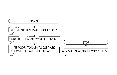
Disclosed vertical seismic profiling (VSP) survey systems and method acquire multi-component signal data and represent the signal data in terms of a combination of parameterized compression, shear, and dispersive wavefields. Multiples of each wavefield type may be included, e.g., to separate upgoing and downgoing wavefield components. A nonlinear optimization is employed to concurrently estimate an incidence angle and a slowness value for each wavefield. For the dispersive wavefield(s), the slowness may be parameterized in terms of a phase slowness and a group slowness with respect to a central wave frequency. The parameter values may vary as a function of depth.


French Abstract

La présente invention porte sur des systèmes et un procédé de prospection de profil sismique vertical (PSV) qui acquièrent des données de signal multi-composante et représentent les données de signal en termes d'une combinaison de compression, de cisaillement et de champs d'ondes dispersifs paramétrisés. De multiples de chaque type de champs d'ondes peuvent être compris, par exemple, pour séparer des composantes de champs d'ondes montantes et descendantes. Une optimisation non-linéaire est employée pour estimer simultanément un angle d'incidence et une valeur de lenteur pour chaque champ d'ondes. Pour le ou les champs d'ondes dispersifs, la lenteur peut être paramétrisée en termes d'une lenteur de phase et d'une lenteur de groupe par rapport à une fréquence d'onde centrale. Les valeurs de paramètre peuvent varier en fonction de la profondeur.

Claims

Note: Claims are shown in the official language in which they were submitted.


CLAIMS
WHAT IS CLAIMED IS:
1. A vertical seismic profiling survey method that comprises:
positioning an array of seismic sensors in a borehole;
receiving multi-component signal data from the array of seismic sensors;
constructing a parameterized wavefield model that includes at least one
compression
wavefield, at least one shear wavefield, and at least one dispersive
wavefield;
applying a nonlinear optimization to fit the model to the multi-component
signal data,
wherein the optimization concurrently estimates an angle of incidence onto the
array of the
seismic sensors for each wavefield and a slowness for each wavefield; and
deriving a subsurface image from one or more of the optimized model's
wavefields,
the image providing a vertical seismic profile of a formation surrounding the
borehole.
2. The method of claim 1, wherein the slowness for the dispersive wavefield
is estimated
as a combination of phase slowness and group slowness with respect to a
central wave
frequency.
3. The method of claim 1, wherein the angle of incidence and slowness for
each
wavefield varies with respect to depth.
4. The method of claim 1, further comprising clamping each of the sensors
against a
wall of the borehole before said receiving.
5. The method of claim 1, wherein the multi-component signal data includes
a vertical
displacement and a radial displacement.
6. The method of claim 1, further comprising:
initiating shots on a surface, wherein said receiving is performed in response
to said
initiating.
7

7. The method of claim 1, wherein the optimized model's wavefields include
an upward-
going compression wavefield, a downward-going compression wavefield, an upward-
going
shear wavefield, a downward-going shear wavefield, and a dispersive wavefield.
8. A vertical seismic profiling survey system that comprises:
an array of multicomponent seismic sensors in a borehole;
a data acquisition system that records multi-component signal data from the
array; and
a processing system that fits a parameterized wavefield model to the multi-
component
signal data using a concurrent determination of an angle of incidence onto the
array of the
seismic sensors for each wavefield and a slowness for each wavefield, the
wavefields
including at least one compression wavefield, at least one shear wavefield,
and at least one
dispersive wavefield, the system providing a vertical seismic profile of a
formation
surrounding the borehole.
9. The system of claim 8, wherein the processing system further derives a
subsurface
image from one or more of said wavefields and displays, on a display device,
said image to a
User.
10. The system of claim 8, wherein the slowness for the dispersive
wavefield is estimated
as a combination of phase slowness and group slowness with respect to a
central wave
frequency.
11. The system of claim 8, wherein the angle of incidence and slowness for
each
wavefield varies with respect to depth.
12. The system of claim 8, wherein the sensors are clamped to a wall of the
borehole or
cemented in place.
13. The system of claim 12, wherein the multi-component signal data
includes a vertical
displacement and a radial displacement.
14. The system of claim 8, further comprising a seismic source that
provides shots at one
or more locations on a surface above the borehole.
8

15. The system of claim 8, wherein the processing system concurrently
determines angle
of incidence and slowness for an upward-going compression wavefield, a
downward-going
compression wavefield, an upward-going shear wavefield, a downward-going shear
wavefield, and a dispersive wavefield.
16. A non-transitory computer readable medium containing computer
instructions stored
therein for causing a computer processor to:
obtain multi-component vertical seismic profiling signal data recorded from an
array
of seismic sensors in a borehole;
construct a parameterized wavefield model that includes at least one
compression
wavefield, at least one shear wavefield, and at least one dispersive
wavefield;
apply a nonlinear optimization to fit the model to the multi-component signal
data,
wherein the optimization concurrently estimates an angle of incidence onto the
array of the
seismic sensors for each wavefield and a slowness for each wavefield.
17. The medium of claim 16, wherein the slowness for the dispersive
wavefield is
estimated as a combination of phase slowness and goup slowness with respect to
a central
wave frequency.
18. The medium of claim 16, wherein the angle of incidence and slowness for
each
wavefield varies with respect to depth.
19. The medium of claim 16, wherein the multi-component signal data
includes a vertical
displacement and a radial displacement.
20. The medium of claim 16, wherein the optimized model's wavefields
include an
upward-going compression wavefield, a downward-going compression-wavefield, an
upward-going shear wavefield, a downward-going shear wavefield, and a
dispersive
wavefield.
21. A vertical seismic profiling survey method that comprises:
positioning an array of seismic sensors in a borehole;
initiating shots on a surface;
9

receiving multi-component signal data from the array of seismic sensors,
wherein said
receiving is performed in response to said initiating;
constructing a parameterized wavefield model that includes at least one
compression
wavefield, at least one shear wavefield, and at least one dispersive
wavefield;
applying a nonlinear optimization to fit the model to the multi-component
signal data,
wherein the optimization concurrently estimates an angle of incidence onto the
array of the
seismic sensors for each wavefield and a slowness for each wavefield;
deriving a subsurface image from one or more of the optimized model's
wavefields,
the image providing a vertical seismic profile of a formation surrounding the
borehole; and
displaying the subsurface image on a display device.
22. A vertical seismic profiling survey system that comprises:
a seismic source that provides shots at one or more locations on a surface
above a
borehole;
an array of seismic sensors in the borehole;
a data acquisition system that records multi-component signal data from the
array of
seismic sensors;
a processing system that fits a parameterized wavefield model to the multi-
component
signal data using a concurrent determination of an angle of incidence onto the
array of
seismic sensors for each wavefield and a slowness for each wavefield, the
wavefields
including at least one compression wavefield, at least one shear wavefield,
and at least one
dispersive wavefield, the system providing a vertical seismic profile of a
formation
surrounding the borehole, deriving a subsurface image from one or more of said
wavefields,
and displaying said image on a display device to a user.

Description

Note: Descriptions are shown in the official language in which they were submitted.


CA 02867430 2014-09-15
WO 2013/151524
PCT/US2012/031788
VSP Systems and Methods Representing Survey Data as
Parameterized Compression, Shear, and Dispersive Wave Fields
BACKGROUND
Vertical seismic profiling (VSP) surveys are useful for measuring the
properties of geological
formations surrounding a borehole. One technique for performing a VSP survey
employs an array of seismic
sensors positioned in an approximately-vertical borehole. A seismic source
creates seismic waves at various shot
locations on the surface. The sensors' responses to each shot are recorded and
analyzed to extract the desired
formation properties.
One formation property commonly measured in this manner is compressional wave
velocity. We note
here that compressional waves can also be termed compression waves,
longitudinal waves, pressure waves.
primary waves, or P-waves. Though the term "velocity" is commonly used, the
measured value is normally a
scalar value, i.e., the speed. This speed, or "velocity", can also be
equivalently expressed in terms of slowness,
which is the reciprocal of speed. (In other words, the product of speed and
slowness is unity.)
Other types of waves may also be generated, either by the seismic source
itself, or by the interaction of
the seismic wave energy with faults, formation interfaces, and solid-fluid
interfaces (e.g., the earth's surface, the
borehole). Such waves include shear waves and dispersive waves. Shear waves
are often termed transverse
waves, secondary waves, or S-waves. Dispersive waves are those waves whose
frequency is not proportional to
their wavenumber, i.e., different wavelengths propagate at different speeds.
As not-necessarily distinct
examples, dispersive waves include guided waves, interface waves, Lamb waves,
Love waves, Q-waves,
Rayleigh waves, Scholte waves, surface waves, Stoneley waves, and tube waves.
Generally speaking, compressional waves have higher velocities and higher
amplitudes, making them
easier to identify and measure particularly because they are the first wave
type to reach the sensor array.
However, shear modulus is a key formation property that can only be derived
from shear wave velocity
measurements. Unfortunately, dispersive waves and delayed compressional wave
arrivals (e.g., delayed due to
reflection and refraction) can obscure the shear waves as they reach the
sensor array, making such
measurements difficult and unreliable.

CA 02867430 2014-09-15
WO 2013/15152-f
PCTTUS2012/031788
BRIEF DESCRIPTION OF THE DRAWINGS
Accordingly, there are disclosed herein in the drawings and detailed
description specific embodiments
of vertical seismic profiling (VSP) survey systems that separate the survey
data into compressional, shear, and
dispersive wavefields. In the drawings:
Fig. 1 shows an illustrative VSP survey environment;
Fig. 2 shows an illustrative VSP survey system;
Fig. 3 shows illustrative seismic traces;
Fig. 4 is a flowchart of an illustrative VSP survey method;
Fig. 5 shows illustrative multi-component VSP survey data;
Figs. 6-8 show illustrative compressional;shear, and dispersive wavefields,
respectively;
Figs. 9a-9c show extracted dispersive wavefield parameters;
Fig. 10 shows illustrative VSP data reconstructed from the wavefields; and
Fig. 11 shows illustrative residual noise components.
It should be understood, however, that the specific embodiments given in the
drawings and detailed description
do not limit the disclosure. On the contrary, they provide the foundation for
one of ordinary skill to discern the
alternative forms, equivalents, and modifications that are encompassed
together with one or more of the given
embodiments in the scope of the appended claims.
DETAILED DESCRIPTION
The disclosed systems and methods are best understood in an illustrative usage
context. Accordingly,
Fig. 1 shows an illustrative vertical seismic profiling (VSP) survey
environment, in which surveyors position an
array of seismic sensors 102 in a spaced-apart arrangement in a vertical
borehole 104. For multi-component
sensing, the sensors are clamped to the borehole wall or cemented in place.
The sensors 102 communicate
wirelessly or via cable to a data acquisition unit 106 that receives,
processes, and stores the seismic signal data
collected by the sensors. The surveyors trigger a seismic energy source 110
(e.g., a vibrator truck) at multiple
positions ("shot locations") on the earth's surface 108 to generate seismic
energy waves that propagate through
the earth 112. Such waves reflect from acoustic impedance discontinuities to
reach the sensors 102. Illustrative
discontinuities include faults, boundaries between formation beds, and fluid
interfaces. The discontinuities may
appear as bright spots in the subsurface structure representation that is
derived from the seismic signal data.
2

CA 02867430 2014-09-15
WO 2013/151521
PCT/US2012/0.31788
Fig. 1 further shows an illustrative subsurface structure. In this figure, the
earth has three relatively flat
formation layers and a dipping formation layer of varying composition and
hence varying speeds of sound. The
formation pores may be filled with gas, water, or oil, which also affect the
speed of sound through the formation.
Fig. 2 shows an illustrative VSP survey recording system having the sensors
102 coupled to a bus 302
to communicate digital signals to data recording circuitry 306. Position
information for the sensors and other
parameters useful for interpreting the recorded data can be detected with
other sensors 304 and provided to the
data recording circuitry 306 for storage. Illustratively, such additional
information can include the precise
locations of the sensors and source firings, source waveform characteristics,
digitization settings, detected faults
in the system, etc.
The seismic sensors 102 may each include multi-axis accelerometers and/or
geophones and, in some
environments, hydrophones, each of which may take high-resolution samples
(e.g., 16 to 32 bits) at a
programmable sampling rate (e.g., 400 Hz to 1 kHz). Recording circuitry 306
stores the data streams from
sensors 102 onto a nonvolatile storage medium such as a storage array of
optical or magnetic disks. The data is
stored in the form of (possibly compressed) seismic traces, each trace being
the signal detected and sampled by
a given sensor in response to a given shot. (The shot and sensor positions for
each trace are also stored and
associated with the trace.)
A general purpose data processing system 308 receives the acquired VSP survey
data from the data
recording circuitry 306. In some cases the general purpose data processing
system 308 is physically coupled to
the data recording circuitry and provides a way to configure the recording
circuitry and perform preliminary
processing in the field. More typically, however, the general purpose data
processing system is located at a
central computing facility with adequate computing resources for intensive
processing. The survey data can be
transported to the central facility on physical media or communicated via a
computer network. Processing
system 308 includes a user interface having a graphical display and a keyboard
or other method of accepting
user input, enabling users to view and analyze the images and other
information derived from the VSP survey
data.
Fig. 3 shows illustrative seismic signals that might be recorded by the system
of Fig. 2. The signals
indicate some measure of seismic wave energy as a function of time (e.g.,
displacement, velocity, acceleration,
pressure). We note, however, that there are normally dozens if not hundreds of
traces, so it is usually infeasible
to show the set of traces associated with any given shot in the separate,
isolated manner of Fig. 3. Rather. the
signals are typically shown in a "waterfall" format such as that seen in Fig.
5, where each signal is given a small
3

CA 02867430 2014-09-15
WO 2013/151524
PCT/US2012/031788
offset from the signals associated with neighboring sensors, but they are
otherwise shown with curves that are
allowed to overlap each other. The overlapping lines create patterns that
reveal trends in the data such as, e.g..
the sloping lines indicating the arrival of seismic waves at the sensor array.
Fig. 4 is a flowchart of a VSP survey method that may be implemented by the
system of Fig. 2. In
block 402, the system obtains the VSP survey data as outlined above. In block
404, the system constructs a
parameterized wavefield model having parameters for at least compressional
waves, shear waves, and dispersive
waves. The structure of this model is set forth in detail below. In block 406,
the system fits the model to the data,
using a nonlinear optimization method to determine the parameters that provide
the best fit. In at least some
embodiments, the system employs the Levenberg-Marquardt algorithm to achieve a
best fit, but other
optimization methods are known and may be employed, including Gauss-Newton,
gradient descent, simulated
annealing, and particle swarm optimization. The parameters determined for each
wavefield are expected to
include slowness and angle of incidence onto the sensor array.
In many cases, the wavefield slowness values may provide sufficient
information to derive logs of the
desired formation properties (e.g., shear modulus as a function of depth). In
other cases, the parameterized
model wavefields are used for further processing, as their noise content is
sharply reduced relative to the
acquired data. Thus the flowchart in Fig. 4 includes a block 408, in which the
system derives a subsurface image
from the parameterized model wavenelds. The fundamentals of seismic imaging
are well-known and accessible
in various textbooks including Jon F. Claerbout, Imaging the Earth's Interior,
Blackwell Scientific Publications,
Oxford, 1985. The derived images, logs, or other representations of derived
formation properties are displayed
by the system as the VSP method reaches completion.
Turning now to the model, we represent the incidence angles of the P-
wavefield, S-wavefield, and
dispersive wavefield, respectively, as ep, 8,, and 61,14. These incidence
angles cause the seismic energy to be
distributed across the vertical and radial signal components in accordance
with the polarization vectors dp, dõ
and ddiv:
¨sin(8 ) [cos(0,) ¨sin(Odisp)
d =Lcos(19P)I ds= ddisp= =
sin(Os)- cos(Odisp)
p _
Thus, if the wavefields have the frequency domain waveforms of wp(w).
tv,(ct;), and wd.p(c0). the two-component
displacements at (reference) sensor 0 can be written
/10 (0= dpwp(0+ il5w5(0+ ddisp;vdisp(0.
4

CA 02867430 2014-09-15
WO 2013/151524 PCT/US2012/031788
-- The measurements at adjacent sensors are related by the frequency-domain
time-shift operators for the P-
wavefield, S-wavefield, and dispersive wavefield, respectively:
lePq 1, Az A hug AZ (mo ( 1
phase + (co-m(4) grrup)Az
= c jisp c s =
where Az is the distance between adjacent sensors, qp and q, are the
slownesses (inverse speed) of the P- =
wavefield and S-wavefield, qp, and qqrp are the phase and group slownesses of
the dispersive wavefield, and
-- oh is a central wave frequency of the dispersive wavefield. For a four-
sensor array, the model equations would
be:
0 0 0
4((t)) d2 d525 ddispA disp
W (CO)
111(co) = d2 dsthd = AI
p p s y', (lisp
ws(a))1.
u2 (01 1 di,22p ds22, ddisp/12di, I
P (Wdis(Mi
,u3 CO)j 3 3 3
d). dA d p
pp ss ch=spA disp
Of course, more sensors (and sensor equations) can be added. In generalized
form the equations can be
expressed:
11(0= G(OW(0
where U(CO) is the measured sensor data, W(CO) is the wavefield vector, and
G(0.)) is the parameterized
model. The eight parameters to be determined are or , qõ. 8., q,, adisp, co),
ciph¨,, and qs,õõp. Given an estimated set
of parameters, the corresponding wavefield estimate is found by the least
squares solution:
( CO) = (GTG)-I G Tt1(0,
and the error between the observed and modeled data is:
E= G(ow(w) - U(01112
The nonlinear optimization algorithm seeks to find the parameter values that
minimize this error. A sliding
window approach may be employed, with signals from, e.g., 9 adjacent sensors
being analyzed at a time. In
addition to making the computation less demanding, this approach enables the
parameter values to change with
-- position to accommodate potential wavefield variations with depth.
We further note that the wavefield vector can be expanded to provide for
multiple wavefields of each
type. Thus, for example, the equations might provide for an upgoing P-
wavefield, a downgoing P-wavefield, an
upgoing S-wavefield, a downgoing S-wavefield, and a downgoing dispersive
wavefield. A greater or lesser
number of wavefields might be chosen based on the experience and intuition of
the user.
5
=

CA 02867430 2014-09-15
WO 2013/151524
PCT/US2012/031788
Figs. 5-11 provide an illustrative use of the disclosed systems and methods.
Fig. 5 shows the geophone-
measured VSP survey signals in terms of vertical and radial displacements. The
sloping lines indicative of
downgoing and upgoing wave fronts are apparent in both components, though the
different wave fronts overlap
and create interference patterns that make their interpretation more
difficult.
Figs. 6-8 show the wavefields extracted from the data of Fig. 5 using the
foregoing method. Fig. 6
shows the downgoing and upgoing P-wavefields. Fig. 7 shows the downgoing and
upgoing S-wavefields. Fig. 8
shows the dispersive wavefield. It can be observed that substantially less
interference exists between wavefields.
Figs. 9a-9c show the extracted parameter values for the dispersive wavefield
of Fig. 8. Fig. 9a shows
the phase velocity as a function of depth. Fig. 9b shows the group velocity as
a function of depth. Fig. 9c shows
the central wave frequency as a function of depth. A gradual decrease of group
velocity and central frequency
can be observed with depth. The phase velocity exhibits a substantial amount
of variation but otherwise does not
seem to have a systematic dependence on depth.
Fig. 10 shows a reconstruction of the vertical and radial signal components
derived by summing the
wavefields of Figs. 6-8. As expected, there is a strong resemblance to the
original data of Fig. 5. Fig. 11 shows
the vertical and radial noise component obtained by subtracting the
reconstructed signals of Fig. 10 from the
original data of Fig. 5. A faint residue of the strongest wavefield components
(the downgoing P-wave and the
dispersive wave) can be seen, attributable to un-modeled nonlinearities.
Numerous variations and modifications will become apparent to those skilled in
the art once the above
disclosure is fully appreciated. It is intended that the following claims be
interpreted to embrace all such
variations and modifications.
6

Representative Drawing
A single figure which represents the drawing illustrating the invention.
Administrative Status

2024-08-01:As part of the Next Generation Patents (NGP) transition, the Canadian Patents Database (CPD) now contains a more detailed Event History, which replicates the Event Log of our new back-office solution.

Please note that "Inactive:" events refers to events no longer in use in our new back-office solution.

For a clearer understanding of the status of the application/patent presented on this page, the site Disclaimer , as well as the definitions for Patent , Event History , Maintenance Fee  and Payment History  should be consulted.

Event History

Description Date
Time Limit for Reversal Expired 2022-03-01
Letter Sent 2021-04-06
Letter Sent 2021-03-01
Letter Sent 2020-08-31
Inactive: COVID 19 - Deadline extended 2020-08-19
Inactive: COVID 19 - Deadline extended 2020-08-06
Inactive: COVID 19 - Deadline extended 2020-07-16
Inactive: COVID 19 - Deadline extended 2020-07-02
Inactive: COVID 19 - Deadline extended 2020-06-10
Inactive: COVID 19 - Deadline extended 2020-05-28
Inactive: COVID 19 - Deadline extended 2020-05-14
Inactive: COVID 19 - Deadline extended 2020-04-28
Inactive: COVID 19 - Deadline extended 2020-03-29
Common Representative Appointed 2019-10-30
Grant by Issuance 2018-09-04
Inactive: Cover page published 2018-09-03
Pre-grant 2018-07-25
Inactive: Final fee received 2018-07-25
Notice of Allowance is Issued 2018-02-02
Letter Sent 2018-02-02
Notice of Allowance is Issued 2018-02-02
Inactive: Approved for allowance (AFA) 2018-01-25
Inactive: Q2 passed 2018-01-25
Amendment Received - Voluntary Amendment 2017-08-02
Inactive: S.30(2) Rules - Examiner requisition 2017-03-10
Inactive: Report - No QC 2017-03-09
Amendment Received - Voluntary Amendment 2016-08-02
Inactive: Report - QC passed 2016-06-02
Inactive: S.30(2) Rules - Examiner requisition 2016-06-02
Amendment Received - Voluntary Amendment 2016-01-28
Inactive: S.30(2) Rules - Examiner requisition 2015-11-16
Inactive: Report - No QC 2015-11-09
Appointment of Agent Requirements Determined Compliant 2015-05-07
Inactive: Office letter 2015-05-07
Revocation of Agent Requirements Determined Compliant 2015-05-07
Appointment of Agent Request 2015-04-02
Maintenance Request Received 2015-04-02
Revocation of Agent Request 2015-04-02
Inactive: Cover page published 2014-12-03
Letter Sent 2014-10-23
Inactive: Acknowledgment of national entry - RFE 2014-10-23
Inactive: First IPC assigned 2014-10-22
Inactive: IPC removed 2014-10-22
Inactive: First IPC assigned 2014-10-22
Inactive: IPC removed 2014-10-22
Inactive: IPC assigned 2014-10-22
Application Received - PCT 2014-10-22
National Entry Requirements Determined Compliant 2014-09-15
Request for Examination Requirements Determined Compliant 2014-09-15
All Requirements for Examination Determined Compliant 2014-09-15
Application Published (Open to Public Inspection) 2013-10-10

Abandonment History

There is no abandonment history.

Maintenance Fee

The last payment was received on 2018-02-21

Note : If the full payment has not been received on or before the date indicated, a further fee may be required which may be one of the following

  • the reinstatement fee;
  • the late payment fee; or
  • additional fee to reverse deemed expiry.

Patent fees are adjusted on the 1st of January every year. The amounts above are the current amounts if received by December 31 of the current year.
Please refer to the CIPO Patent Fees web page to see all current fee amounts.

Fee History

Fee Type Anniversary Year Due Date Paid Date
MF (application, 2nd anniv.) - standard 02 2014-04-02 2014-09-15
Basic national fee - standard 2014-09-15
Registration of a document 2014-09-15
Request for examination - standard 2014-09-15
MF (application, 3rd anniv.) - standard 03 2015-04-02 2015-04-02
MF (application, 4th anniv.) - standard 04 2016-04-04 2016-02-18
MF (application, 5th anniv.) - standard 05 2017-04-03 2017-02-13
MF (application, 6th anniv.) - standard 06 2018-04-03 2018-02-21
Final fee - standard 2018-07-25
MF (patent, 7th anniv.) - standard 2019-04-02 2019-02-15
Owners on Record

Note: Records showing the ownership history in alphabetical order.

Current Owners on Record
LANDMARK GRAPHICS CORPORATION
Past Owners on Record
RICHARD D. FOY
Past Owners that do not appear in the "Owners on Record" listing will appear in other documentation within the application.
Documents

To view selected files, please enter reCAPTCHA code :


To view images, click a link in the Document Description column. To download the documents, select one or more checkboxes in the first column and then click the "Download Selected in PDF format (Zip Archive)" or the "Download Selected as Single PDF" button.

List of published and non-published patent-specific documents on the CPD .

If you have any difficulty accessing content, you can call the Client Service Centre at 1-866-997-1936 or send them an e-mail at CIPO Client Service Centre.


Document
Description 
Date
(yyyy-mm-dd) 
Number of pages   Size of Image (KB) 
Drawings 2014-09-14 8 1,465
Claims 2014-09-14 3 108
Representative drawing 2014-09-14 1 6
Description 2014-09-14 6 222
Abstract 2014-09-14 1 60
Claims 2016-01-27 3 108
Claims 2016-08-01 3 104
Claims 2017-08-01 4 150
Representative drawing 2018-08-06 1 7
Acknowledgement of Request for Examination 2014-10-22 1 176
Notice of National Entry 2014-10-22 1 202
Courtesy - Certificate of registration (related document(s)) 2014-10-22 1 103
Commissioner's Notice - Application Found Allowable 2018-02-01 1 163
Commissioner's Notice - Maintenance Fee for a Patent Not Paid 2020-10-18 1 549
Courtesy - Patent Term Deemed Expired 2021-03-28 1 540
Commissioner's Notice - Maintenance Fee for a Patent Not Paid 2021-05-17 1 536
Final fee 2018-07-24 2 68
PCT 2014-09-14 5 353
Correspondence 2015-04-01 3 85
Fees 2015-04-01 2 68
Correspondence 2015-05-06 1 25
Correspondence 2015-05-06 1 27
Examiner Requisition 2015-11-15 3 225
Amendment / response to report 2016-01-27 18 772
Examiner Requisition 2016-06-01 3 221
Amendment / response to report 2016-08-01 20 854
Examiner Requisition 2017-03-09 4 242
Amendment / response to report 2017-08-01 21 939