Note: Descriptions are shown in the official language in which they were submitted.
CA 02875913 2014-12-05
WO 2013/186559
PCT/GB2013/051545
1
Methods for Determining Material and/or Subsurface Composition
This invention relates to methods, apparatus, and computer code for
determining
composition of different materials, and in particular for producing Virtual
Borehole
logs, more particularly electromagnetic (EM) data from an EM field survey to
provide a representation of the underlying geology of the surveyed region.
In a first aspect of the invention there is provided a method of determining
subsurface composition of a surveyed region comprising the steps of:
using a transmitter to transmit a pulsed electromagnetic signal into the
ground;
using a receiver to detect a return signal following interaction of said
transmitted
signal with features of the subsurface;
imaging a profile image of the subsurface (this may be in in one, two, three
or four
dimensions);
calculating one or more spectra of said return signal, said one or more
spectra
comprising one or more of an energy-frequency spectrum, a phase-frequency
spectrum, a phase-energy and an energy-frequency spectrum;
analysing said one or more spectra to determine a characteristic energy-
frequency
signature, phase-frequency signature, phase-energy signature and/or energy-
frequency signature for one or more layers of said subsurface; and
comparing said determined signature(s) of the one or more layers to a database
of
equivalent signatures of known materials in order to determine a composition
of
said one or more layers.
Said profile image may be obtained by performing a profile scan wherein the
transmit and detect steps are repeated at a plurality of different points over
said
subsurface, in each case said transmitter and receiver being maintained at a
set
separation.
.. Said method may comprise a further scan in order to obtain depth
information for
said profile image of the subsurface. Said further scan may comprise a Wide
Angle
Reflection and Refraction scan. This Wide Angle Reflection and Refraction scan
may
CA 02875913 2014-12-05
WO 2013/186559
PCT/GB2013/051545
2
comprise repeating the transmit and detect steps at a plurality of different
points
over said subsurface, with each repetition being performed with either one of
said
transmitter and receiver being moved, and the other of said transmitter and
receiver remaining stationary. Alternatively said scan may comprise a common
midpoint scan wherein the transmit and detect steps are repeated with each
repetition being performed with said transmitter and receiver being moved
apart
from one another in equal distance steps, or at equal velocities, from a
common
point. In either case the depth information may be obtained using ray tracing
and/or
Normal Move-out techniques. In one embodiment, both of these techniques are
performed and subsurface features are only attributed with depth information
when the solutions using both techniques are in correlation.
Said method may comprise obtaining a phase-frequency spectrum based upon the
variation of phase of the return signal in the frequency domain, and
determining
characteristic phase-frequency signatures. In one embodiment the calculation
step
provides both an energy-frequency spectrum, and a phase-frequency spectrum and
said analysing step comprises analysing said energy-frequency spectrum and
phase-
frequency spectrum to obtain a characteristic energy-phase-frequency signature
for
one or more layers of said subsurface.
In one embodiment, said step of analysing said one or more spectra comprises
performing a statistical analysis of said one or more spectra.
Said statistical analysis may include at least one of principal components
analysis,
maximum likelihood classification and multivariate classification. Said step
of
analysing said one or more spectra may comprise frequency classification using
energy bins and/or frequency bins.
Said method may comprise performing a rank matching operation wherein each
determined signature is compared against every other equivalent signature, and
covariance and correlation matrices are computed.
CA 02875913 2014-12-05
WO 2013/186559
PCT/GB2013/051545
3
Said energy-frequency signatures and/or phase-frequency signatures may be
output
as spectral lines and compared to a database of spectral lines in said
comparison
step.
Said method may comprise obtaining energy-frequency signatures defined by
energy changes at a plurality of different harmonics for a plurality of
derivatives.
Said number of derivatives may comprise more than 5 derivatives, more than 10
derivatives, or more than 15 derivatives. Said plurality of different
harmonics may
comprise more than 5 harmonics, more than 10 harmonics, more than 20 harmonics
or more than 30 harmonics. In this embodiment said signatures may be defined
by
the sign of the energy change at each of said harmonic.
Said method may further comprise building said database by performing said
method on subsurfaces and/or material of known composition.
Said pulsed signal may be a broadband electromagnetic signal (such as radar
frequencies, radiowaves, microwaves)..
In a second aspect of the invention there is provided a method of typecasting
a
subject comprising the steps of irradiating the subject with a pulsed signal
transmitted by at least one transmitter antenna; detecting a return signal
following
interaction of said transmitted signal with said subject, using at least one
receiver
antenna; calculating a phase-frequency spectrum of said return signal; and
analysing said phase-frequency spectrum to obtain a characteristic phase-
frequency
signature of said subject.
Said pulsed signal may be a broad band electromagnetic signal (such as radar
frequencies, radiowaves, microwaves)..
Said phase-frequency spectrum may be based upon the variation of phase of the
return signal in the frequency domain. In one embodiment the calculation step
provides both an energy-frequency spectrum, and a phase-frequency spectrum and
CA 02875913 2014-12-05
WO 2013/186559
PCT/GB2013/051545
4
said analysing step comprises analysing said energy-frequency spectrum and
phase-
frequency spectrum to obtain a characteristic energy-phase-frequency signature
for
one or more layers of said subsurface.
In one embodiment, said step of analysing said phase-frequency spectrum
comprises performing a statistical analysis of said phase-frequency spectrum.
Said statistical analysis may include at least one of principal components
analysis,
maximum likelihood classification and multivariate classification. Said step
of
analysing said phase-frequency spectrum may comprise frequency classification
using energy bins and/or frequency bins.
Said method may comprise performing a rank matching operation wherein each
phase-frequency signature is compared against every other phase-frequency
signature, and covariance and correlation matrices are computed.
Said phase-frequency signatures may be output as spectral lines and compared
to a
database of spectral lines in said comparison step.
Said method may further comprise building said database by performing said
method on subsurfaces and/or material of known composition.
Said method may be performed on similar solutions of differing concentrations
in
order to distinguish between and/or determine the concentrations of said
solutions.
.. Said method may be performed on one of a gas mixture, liquid mixture, solid
mixture, powder mixture or multiphase mixture in order to distinguish between
and/or determine the amounts of the constituents comprised in said mixtures.
4a
The invention further provides a method of determining subsurface composition
of a surveyed region
comprising the steps of: using a transmitter to transmit a pulsed
electromagnetic signal into the ground;
using a receiver to detect a return signal following interaction of said
transmitted signal with features of
.. the subsurface; imaging a profile image of the subsurface; calculating one
or more spectra of said return
signal, said one or more spectra comprising at least a phase-frequency
spectrum based upon the
variation of phase of the return signal in the frequency domain and an energy-
frequency spectrum;
analysing said one or more spectra to determine a characteristic phase-
frequency signature and an
energy-frequency signature for one or more layers of said subsurface; and
comparing said determined
signatures of the one or more layers to a database of equivalent signatures of
known materials in order
to determine a composition of said one or more layers; wherein said analysing
step comprising defining
said energy-frequency signature by energy changes at more than 10 different
harmonics for each of
more than 10 derivatives of the energy-frequency spectrum, such that said
energy-frequency signature
is defined by the sign of the energy change at each of said harmonics.
Date recu/Date Received 2020-07-09
CA 02875913 2014-12-05
WO 2013/186559
PCT/GB2013/051545
BRIEF DESCRIPTION OF THE DRAWINGS
Embodiments of the invention will now be described, by way of example only, by
reference to the accompanying drawings, in which:
5
Figure 1 is a high-level flow diagram of a method according to an embodiment
of the
present invention;
Figure 2 is a flow diagram of the data processing elements forming part of a
method
according to an embodiment of the present invention;
Figure 3 is an illustration of a survey site during three phases of a survey
scan;
Figure 4 is a time domain representation of a transmitted EM pulse transmitted
in
embodiments of the invention;
Figure 5 is an illustration of the axial ray paths between transmitter and
receiver;
Figure 6 shows an illustration of the matching step of the HILDA workflow
according to an embodiment of the invention;
Figure 7 is a polar plot of cumulative energy, phase and amplitude against
frequency;
Figure 8 is a flow diagram of a typecasting process forming part of a method
according to an embodiment of the present invention; and
Figure 9 is Spectral Line output representation obtained using a method
according
to an embodiment of the present invention.
CA 02875913 2014-12-05
WO 2013/186559
PCT/GB2013/051545
6
DETAILED DESCRIPTION OF THE EMBODIMENTS
Glossary of Terms Used In the Description
E-ADR
Energy-ADR - the resonant energy measurement of a subsurface layer of measured
thickness
FFT Analysis
Fast Fourier Transform Analysis is a technique for spectral analysis of
signals. The
analysis of the returned ADR signals from the subsurface to the ADR receiving
system is performed by FFT analysis of the received spectrum (which includes
radio
waves and microwaves). This results in mathematical and statistical analysis
of the
received spectrum and the recognition of energy, frequency and phase
relationships. More detailed spectrometric analysis is achieved through the
quantum electrodynamic (QED) approach (Feynman, 1985) by quantising the entire
ADR receive spectrum. In ADR quantum theory, this is similar to the equal
temperament system of tuning musical instruments - in which each pair of
adjacent
musical notes has an identical frequency ratio. In this "tuning" methodology,
an
interval (usually an octave) is divided into a series of equal steps, with
equal
frequency ratios between successive notes. For example, a violin is tuned in
perfect
fifths. The notes are G - D - A - E; where the fundamental G is 192 Hertz, D
is 288
Hertz, A is 432 Hertz and E is 648 Hertz. Note that a perfect fifth is in a
3:2
relationship with its base tone. The octave frequency interval is covered in
seven
steps (A, B, C, D, E, F and G) and each tone is the ratio of the 7th root of
3/2, or in
mathematical form [(3/2) ^ (1/7)]. For ADR, the quantised frequency spectrum
includes 3 octaves of the radiowave spectrum and 33 octaves of the microwave
spectrum. When ADR is applied to geological analysis, rocks can be genetically
classified by notes and octaves using the above spectrometric approach.
Harmonic Analysis
Harmonic analysis is the branch of mathematics that studies the representation
of
functions or signals as the superposition of basic waves. It investigates and
generalizes the notions of Fourier series and Fourier transforms. The basic
waves
CA 02875913 2014-12-05
WO 2013/186559
PCT/GB2013/051545
7
are called "harmonics" (in physics), hence the name "harmonic analysis," but
the
name "harmonic" in this context is generalized beyond its original meaning of
integer frequency multiples.
Harmonic Analysis is a widely accepted technique for assessing materials in a
laboratory setting in the chemical industry. However, to date, it has not been
commercially applied to classify subsurface geology or mineralogy using remote
sensing geophysical technology from the ground surface. Unique harmonic energy
frequency and phase peaks are produced and can be analysed in a number of ways
producing a range of parametric statistical tests. Different rock types with
different
mineral assemblages will exhibit different spectral harmonic relationships
over
these levels.
Harmonic Phase
The phase information is stored such that a pixel with a phase angle of zero
will
have an intensity of zero. The intensity increases linearly with phase angle,
until
almost 360 degrees.
HILDA - Hyperspectral Invisible Light Dynamic Analysis
A differential method of correlating spectral energy datasets to allow the
spectral
discrimination of materials.
P- Scan
Profile Scan of the subsurface with fixed focus Antenna spacings at ground
level.
Both Transmitting and Receiving Antennas are moved simultaneously in parallel
along the length of the scan line. This produces an image of the subsurface
(from
ground level) based on the two-way travel time of Adrok ADR Scanner's beams
from
Transmitter to Receiver Antenna. The WARR data converts the P-Scan time-stamps
into depths in metres.
RADAMATIC
Suite of Processing Software (Adrok Proprietary)
Rank Matching
A statistical matching method developed by Adrok for comparing one image to a
database of many images. Utilises eigen distance measurement to "rank" closest
matches
CA 02875913 2014-12-05
WO 2013/186559
PCT/GB2013/051545
8
Sub-Images
2-dimensional cross-sectional images of the subsurface are produced from the P-
Scans. Sub-images are specific blocks of these images.
Survey Points
.. The ground location of the Adrok Virtual Borehole scan (akin to the collar
position
of a physically drilled borehole)
Typecasting
Term used by Adrok to describe the process of identifying and classifying
materials
(e.g. rocks, soil and sediments).
V-bore
Short for "Virtual Borehole" produced by the Adrok Scanner
WARR
Wide Angle Reflection and Refraction scan to triangulate subsurface depths
from the
surface ground level. The Transmitting Antenna is moved at ground level along
the
scan line, away from the stationary Receiving Antenna which is fixed to the
start of
the scan line. Collected by ADR Scanner at ground level (that produces depth
calculations).
The goal of most geophysical field surveys is to deduce the sub-surface
geology. The
electromagnetic (EM) survey, described herein, searches for signatures which
potentially indicate valuable mineral deposits, rock types and fluid content,
based
on dielectrics, EM energy, frequency and phase relationships. The method may
be
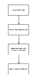
expressed in general terms using the flow diagram shown in Figure 1.
Figure 1 shows that, initially one or more scanning steps are performed, where
an
EM pulse is transmitted from a transmitter into the ground. The EM pulse is
reflected from the boundaries between different subsurface layers and the
reflected
signals are received at a receiver. Transmitter and receiver may be of a type
as
described in WO 01/18533. The reflected signals are processed to determine the
depth and dielectric constant of each layer within the subsurface. Processing
may
involve conducting WARR and/or CMP analyses to produce depth information for
the time registered image. This is integrated with profile scan data to
provide a
CA 02875913 2014-12-05
WO 2013/186559
PCT/GB2013/051545
9
depth correlated image of the subsurface. Triangulation of each subsurface
interface
is enabled by ray tracing and NMO computations. The received signals, depth
data
and/or dielectric constant data are compared with known data (from physically
drilled or cored boreholes) and also EM data collected from core samples in
the
laboratory to determine the type of material of each subsurface layer and its
depth
below ground. The determined material and depth information may be used to
produce a virtual borehole log.
Other methods employ "chamber" modes in which a sample of material under
investigation is enclosed in a chamber, the transmitter antenna being arranged
to
irradiate the interior of the chamber and the receiver antenna being arranged
to
receive signals modified by the interaction of the transmitted signals with
the
chamber and its contents. This method is particularly useful for typecasting
particular substances.
Figure 2 shows an overview of an embodiment of the main process described in
detail below. It shows the process steps in obtaining a Virtual Borehole Log.
CA 02875913 2014-12-05
WO 2013/186559
PCT/GB2013/051545
Atomic Dielectric Resonance (ADR)
The concepts described herein employ a technique known as Atomic Dielectric
Resonance (ADR). ADR is an investigative technique which involves the
5 .. measurement and interpretation of resonant energy responses of natural or
synthetic materials to the interaction of pulsed electromagnetic radio-waves,
micro-
waves, millimetric or sub-millimetric radio-waves from materials which permit
the
applied energy to pass through the material. The resonant energy response can
be
measured in terms of energy, frequency and phase relationships. The precision
with
10 which the process can be measured helps define the unique interactive
atomic or
molecular response behaviour of any specific material, according to the energy
bandwidth used. ADR is measurable on a very wide range of hierarchical scales
both
in time and space. Time scales may range from seconds to femtoseconds, and
spatial
scales from metres to nanometres.
One of the best ways of thinking about rock layers underground is to consider
an
"Einstein-type conceptual model" of relatively regular rock layers like
shelves in a
bookcase. This can be readily visualised in the laboratory. Geologists should
imagine themselves standing on the roof of the laboratory bookcase, above the
top
shelf, and scanning a line across the top-shelf roof, parallel to the shelves
but looking
vertically down at 90 degree inclination angle to the horizontal. The ADR beam
of
radio waves and microwaves is first lased in the telescope and then it is
launched
into the air medium from the aperture of the telescope, from which it speeds
up and
then it hits the first interface, which is the wood at the top of the
bookcase. It is
.. transmitted through the wooden top into the first empty shelf canopy which
is air
filled only (imagine no books on the top shelf) and then it hits the wooden
base of
the shelf and is reflected back to the top. Because the beam is continually
being
pulsed and it is lased it now resonates up and down in a series of peg-legs
between
the top and bottom of the first shelf.
It is then forced by transmission to move down into the second shelf and
repeat this
process by resonating in a series of peg-legs between the top and bottom of
the
CA 02875913 2014-12-05
WO 2013/186559
PCT/GB2013/051545
11
second shelf. The geologist should now imagine that the first four or five
shelves are
not empty (air-filled) but are made up of rectangular blocks of rock-
sandstone,
siltstone, shale, coal, etc.( so that the beam slows down through different
dielectric
layers depending on the variable dielectric constants) . He will then see that
the
resonance (peg-leg reflections) between the top and bottom of each rock layer
in
each shelf are different and most important are measurable. The transmission
times
and delay times of the resonant reflections through each rock layer are
variable
depending on the rock physics parameters such as dielectric constants,
absorbance,
porosity, for example. In addition, there are special spectral associations
related to
the physical parameters such as energy, frequency and phase relationships and
the
statistical parameters associated with these spectral variables such as means,
medians and modes together with minimum, maximum and standard deviations, for
example.
This is the whole process of what can be described as "atomic dielectric
resonance"
(or ADR) of photon beams being transmitted through materials) and geologists
can
precisely map what happens to the confocal ADR laser beam as it is being
transmitted through these layers. They can precisely track this beam as it
progresses through the bookcase of rock layers, and as it passes through each
layer
software can tell the geologist the mean velocity through each layer, the mean
dielectric constant, the delay times and three-dimensional dispersion of the
beam
with depth (in the radial Y-direction as it proceeds down in the Z-direction)
so that
they can map the three dimensional structure of the beam (which tells him its
precise footprint through each rock layer). This is how the geologist can
confirm
that the laser beam of radio waves and microwaves is not only coherent but
also
confocal with an intensity pattern which slightly decreases with depth. The
beam
gradually narrows with depth as it goes deeper but the energy values with each
layer are consistently high. This is why it is so useful for geologists
involved in
mineral prospecting because it can identify narrow veins with great precision.
Some aspects of the field and laboratory ADR equipment involve certain
conditions
being satisfied during the set up of the apparatus so as to obtain "standing
wave
CA 02875913 2014-12-05
WO 2013/186559
PCT/GB2013/051545
12
oscillations" in ADR test sample chambers and / or in ADR remote sensing
antenna
system assemblies. In this respect, it is desirable to selectively control the
group
velocity of the radio wave and microwave radiation as it is emitted or
"launched" by
the transmitting antennas into the ground. In particular, for deep scanning
the
launch speed of the wave should be sufficiently slow to ensure that the wave
can be
accurately registered at a precise "zero time" location by the receiver
antennas, after
the pulse has been transmitted. The zero time position t(z) in remote sensing
or t(0)
in geophysics, is the start position for ADR range measurements and must be
identified on the received ADR signal to determine the true time range (in two
way
travel time, (TWT- usually measured in nanoseconds)) represented by the
received
signal, returning from each resonant subsurface reflection layer.
The Wide Angle Reflection and Refraction (WARR) tracking method, which is one
of
the scanning methods comprised in ADR and will be described further, is able
to (a)
identify the upper and lower boundaries of each stratum, (b) determine the
inter-
layer beam velocity and mean dielectric constant of the material in each
stratum and
(c) identify the materials in the various strata from both the dielectric
constants,
known molecular or atomic spectral lines (after FFT Analysis of the received
signals) and spectral ADR statistical parameters data-based for known rock
types.
Three main measurements may be comprised in the proposed ADR method:
(1) Dielectric permittivity measurement
Conventional radar can locate objects in a less dense medium (e.g. a plane in
the sky
or a shallow buried object in the ground) because those objects reflect back
some of
the signal. Radar can also detect the dielectric constants of materials
penetrated.
Ground penetrating radar can therefore detect boundaries with different
dielectric
constants (rather as seismic detects changes in acoustic impedance). ADR is
not
depth constrained whereas conventional ground penetrating radar is limited to
very
shallow depths.
CA 02875913 2014-12-05
WO 2013/186559
PCT/GB2013/051545
13
ADR accurately measures the dielectric permittivity of materials encountered
and
determines the Dielectric Constant (DC) of each layer of rock to an accuracy
of at
least 1:400. With deeper penetration and a narrower ADR beam, the accuracy of
dielectric mapping improves and at 1km depth an accuracy of 1:4000 can be
achieved for the mean dielectrics of narrow layers at this depth. The
dielectric
constant is basically a measure of how much a given material will slow down
the
ADR transmission signal. Determining the dielectric constant of each layer
enables
each rock layer to be mapped with a depth computation from ground level and
can
also determine physical properties of the rock layer, such as moisture
content,
porosity and density indices.
Dielectrics also allows preliminary identification of the composition of each
layer
e.g. shale or sandstone.
In general, dielectric measurements for hydrocarbon layers in the earth tend
to be
between two and five for an ADR Scanner as disclosed herein, if water is
absent. In
geological terms, the main effect on the signals velocity as it propagates
through the
material is the water content. For example, air has a DC of one, whilst water
has a DC
of approximately 80. Most geological materials lie within these boundaries.
(2) Accurate Depth measurements (by two independent methods)
The ADR Scanner can measure depths to each subsurface horizon that provides
reflectance and a change of beam velocity. Two independent methods are
proposed
on order to calculate depths to each horizon: (a) Normal Move Out (NMO), and
(b)
Ray Tracing. Only when both methods give the same depth measurement will that
depth reading be accepted (this is called parallax). These depth measurements
can
be used to help tie-in or improve depth measurements made by seismic tools.
CA 02875913 2014-12-05
WO 2013/186559
PCT/GB2013/051545
14
(3) Spectrometric measurement
The most important result of ADR's ability to penetrate all materials is that
all the
current imaging techniques of spectrometry become available to identify all
materials encountered subsurface. Identification of these materials is based
upon:
= absorption and reflection and emission of different wavelengths of
electromagnetic radiation
= many different relationships of components in the returned signals e.g.
energy /
frequency/ phase relationships
After the subsurface has been divided into its geological horizons by
determining its
dielectric constant, spectrometry is used. The principle is as follows. The
ADR
system analyses many components of the return signal from a location where the
geology is known and learns what return signals each material emits (i.e. the
material is "typecast"). When ADR encounters an unknown material in the
subsurface, it performs a comparison of the return signals obtained from that
material with the contents of a database of known typecast materials until it
finds a
match. The material encountered is then identified. For example, oil bearing
sands,
water bearing sands and shales encountered in previous wells are typecast in
an
area. Then the ADR response from a target formation in an undrilled prospect
is
compared to those typecast formations until a match is achieved. This
identifies the
undrilled target formation. The database may be include signatures of many
different rocks containing different combinations of oil, gas, water, etc.
Ultimately
ADR will be able immediately to classify any formation encountered by
comparing it
with this database. Other, already existing databases can also be used. These
include
NASA's JPL spectral library or the NIST Atomic Spectra Database.
Output
For the oil and mining industry ADR may be used to generate a virtual well log
i.e.
information equivalent to that derived from a drilled and logged well.
CA 02875913 2014-12-05
WO 2013/186559
PCT/GB2013/051545
The output may take the form of:
1. Spectrometric material classification of subsurface layers - e.g.
Virtual
log providing material classification
5 2. Image of the subsurface - e.g. Profile scan
3. Logs:
a. Dielectric Log - showing dielectric permittivity curves- a
dielectric curve is produced by processing the WARR image.
Hyperbolic curves are fitted to image features, the severity of the
10 curve determining the dielectric constant of that layer. A
specific
example uses a WARR sampling interval of 2.5m and utilise two
depth calculation algorithms to produce accurate depth
information from the dielectric curve fits.
b. Energy Log: the energy log is produced by sub-sampling the P-
15 Scan image data in equal time intervals. A Fourier Transform is
conducted on each sub-image, whereby the energy and frequency
content is computed. A mean energy decibel value is calculated
for each sub-image, which provides the energy reading at that
depth.
c. Weighed Mean Frequency: the weighed mean frequency (WMF)
log is produced by sub-sampling the P-Scan image data in equal
time intervals. A Fourier Transform is conducted on each sub-
image, whereby the energy and frequency content is computed.
The frequency values are then modulated with the energy values
to produce the WMF reading per depth interval.
Outputs of its Dielectric Log and the Virtual Logs can be provided, for
example, in
ASCII format, to allow a client to input these measurements into their own
software
models of the survey site(s).
CA 02875913 2014-12-05
WO 2013/186559
PCT/GB2013/051545
16
Scanning Techniques
The following sections outline a number of scanning techniques that may be
utilised.
These comprise:
1. Profile Scans (or PScans) with a fixed base separation between Tx and Rx
antenna(s). These
show a 2-Dimensional (2D) cross-section of the
material(s) under inspection with distance on the x-axis and time on the y-
axis; and
2. Wide Angle Reflection and Refraction (or WARR Scans) which converts y-
axis of PScan data into depth units (by measurement triangulations between
Tx and Rx antenna(s)).
3. Common Midpoint (CM F)
4. Transillumination
5. Stare scan
In each case, the antennas can be used in a variety of ways. The following
list is a
selection of the ways in which they can be used:
= Monostatic - one sensor acts as a Transmitter (Tx) and a Receiver
(Rx), however direct depth calculation can not be achieved by this
method unless the permittivity of the materials of propagation are
known prior to data analysis
= Bistatic - consists of two antennas, one Tx and one Rx. These can be
moved together or independently which provides great flexibility in
the type of measurement that can be performed.
= Array - consists of either:
a) One Tx and more than one Rx
b) One Rx and more than one Tx
c) More than one Tx and More than one Rx
CA 02875913 2014-12-05
WO 2013/186559
PCT/GB2013/051545
17
Array sizes are normally limited by the physical space in which to scan, the
electronic systems available to collect multiple data channels and the cost
and
complexity involved in developing such systems.
Note that "monostatic" and "bistatic" do not mean that the antenna systems are
stationary as they can be moved and operated in any axis.
All the different scan types described below can be used to develop a database
of
known situations or materials (depending on how they require to be scanned).
This
database becomes a reference datum for other measurements and spectral
matching techniques can be employed to match unknown situations/materials to
the known situations. A description of the scan types employed by the Inventor
follows after a general overview of the transmitter and receiver techniques
employed.
Transmitting EM Pulse and Receiving Reflected Signals
Figure 3 shows a survey site during three phases of a survey scan (here a WARR
scan). Shown is a transmitter Tx and a Receiver Rx, Rx' Rx" in three different
positions. Also shown is the subsurface comprising a number of reflective
horizons
200, defining subsurface layers therebetween. At each of these horizons, the
transmitted signal 210 is reflected. Features of the signal are altered by
subsurface
features resulting in a return signal 220 with unique signature depending on
the
path taken by the signal between transmitter and receiver and the subsurface
composition/geology through this path. In particular, each of the layers of
the
subsurface has a dielectric constant. The dielectric constant of a subsurface
layer
affects the rate of propagation of the transmitted signal through the material
of that
layer.
The transmitted signal travels through the layers of the subsurface. Some of
the
energy of the signal is reflected by each boundary between the layers. The
remainder of the energy in the Signal continues through the further layers.
The
CA 02875913 2014-12-05
WO 2013/186559
PCT/GB2013/051545
18
reflected signals are received at the receive antenna some time after signal
transmission. The time of receipt of the reflected signal is dependent on the
dielectric constant of the material(s) of the subsurface layer(s) travelled
through
and the thickness of the subsurface layer(s). In addition, the transmitted
pulse may
be refracted at the boundary between the layers according to Snell's Law.
The signal 210 is initially sent to the transmitting antenna where it is
conditioned
before being launched remotely, e.g. vertically or at a declined look-angle
into the
ground. The transmitting antenna contains dielectric lenses that helps focus
the
signal inside the antenna. This helps condition the velocity with which the
signal
exits the end aperture of the antenna before it is sent into the ground.
The optimum lasing performance of the antennas was achieved by selection of
appropriate dielectric lens configurations to optimise the standing wave
effects
within the transmission chambers and minimise aperture attenuation. The best
lasing performance for imaging can be achieved by plotting of the Transmission
Coefficient (S21, dB) against frequency, which shows a progressive standing
wave
transmission through the chamber with sequential pulsing nodes at key
frequency
levels but a balanced pure input reflection coefficient (S11, dB) when plotted
against
frequency.
The production of the pulse triggers a signal to be sent to the receive
circuitry to
listen for reflected signals from subsurface features. The reflected signals
220 are
collected by the receive antenna Rx, amplified in a pre amplifier and then
have a
time varying gain applied. The time varying gain increases the level of gain
as the
time from EM pulse transmission passes. This compensates for the increased
attenuation of the reflected signal with depth travelled. The reflected
signals are
then passed through an analogue to digitial converter (ADC) and stored within
the
receive antenna apparatus. The storage of reflected signals at the receive
antenna
apparatus allows the data to be transferred to a data logger and/or data
processor
at a later time. Additionally or alternatively the reflected signals may be
transmitted
CA 02875913 2014-12-05
WO 2013/186559
PCT/GB2013/051545
19
across a data link to a data logger and/or data processor. Data can be backed-
up
and removed on a removable storage device (such as a flash drive).
A time domain representation of the transmitted EM pulse is shown in Figure 4.
The
y-axis of this image shows Energy (or amplitude, represented by 0 to 100%) and
the
x-axis represents time (typically in nanoseconds, us). The amplitude of the
pulse
displayed can be seen to be 1.5volts from the major tick marks at 0.5volt
intervals.
Note the 500mv scale is stated bottom left.
The transmitted waves have two components: (i) a long wavefront standing wave
to
obtain deep penetration; and (ii) shorter resonance waves within the standing
wave
to enhance vertical resolution.
Profile scanning (P-scan)
Profile scanning (P-scan) is a type of scan used to produce an image of the
subsurface. It can also be used in spectral analysis, whereby different sub-
images
are used to match against the database. Sub-images are generally in two forms:
= Fixed time (vertical) across the whole area to be analysed
= Fixed time (vertical) across part of the area to be analysed
A P-Scan is conducted by holding transmit and receive antennas at a fixed
separation, and moving these antennas along a measured lateral distance along
a
ground surface, called a survey line. Electromagnetic (EM) pulses are
transmitted
vertically (or at an angle off-vertical) into the subsurface as the transmit
and receive
antennas are moved along the survey line. Each transmitted EM pulse is
reflected
from features within the subsurface to produce, at the receive antenna, a
continuous
signal trace.
The amplitude of the signal received from a reflector varies with the
propagation
coefficient of the material through which the pulse is transmitted, which is
related
to the dielectric constant of this material. Because a resonant (ringing)
pulse has
CA 02875913 2014-12-05
WO 2013/186559
PCT/GB2013/051545
been generated, the pulse also being optimised by lasing, it is possible to
observe the
reflected ringing pulse. Of particular interest is the modulation of the
rings, which
can be used as a diagnostic tool to identify material types. Modulation
effects can be
studied by energy, frequency and phase relationships caused by the modulated
5 ringing reflections. It is then possible to mathematically evaluate the
returns by
typecasting different materials in the laboratory under controlled boundary
conditions such as (a) totally dry rocks (e.g. cooked in a microwave to remove
all
moisture) and (b) totally saturated in water (over 10 days for example) to
study
responses of totally saturated rock materials.
A number of P-Scans are conducted along a survey line. The scan traces may be
placed adjacent one another to produce a P-Scan image wherein the amplitude of
each scan trace is represented by contrast to show the subsurface layers. The
P-Scan
image has two axes: an x-axis comprising the number of P-Scan traces that are
placed adjacent to each other to obtain the image, which is proportional to
distance
along the survey line; and a y-axis that comprises the time after EM pulse
transmission of receipt of the reflected signal.
The P-Scan is a time domain measurement, with time in the y-axis. The depths
obtained from a WARR Scan or CMP scan (see below) can be applied to the P-Scan
to
give the P-Scan a depth dimension in the y-axis.
WARR Scanning
The WARR analysis method generates information about the sub-surface
reflectors
that the ADR signals propagates through and is reflected from. WARR analysis
is
time based and utilises two calculation methods that individually calculate a
travel
time to the sub-surface reflectors. The calculation methods are called NMO
(Normal
Move-out) and Ray Tracing. Both methods are widely used in seismic data
processing. From this travel time, two important factors can be derived,
firstly
dielectric constant of the material through which the signal has been
propagated.
Secondly, the thickness of the layers that the signal has propagated through
can be
CA 02875913 2014-12-05
WO 2013/186559
PCT/GB2013/051545
21
summed to provide an overall depth of penetration from the sensor datum (for
example, the ground surface).
WARR scans are conducted over a set horizontal distance, whereby the first
half of
the horizontal line contains data, averaged over the horizontal distance,
regarding
the depth information to reflectors.
A WARR Scan is conducted by holding one of the transmit antenna or the receive
antenna stationary and moving the other of the transmit antenna or the receive
antenna across the ground over a survey line of the survey site. In the
example
shown in Figure 3, the transmit antenna remains stationary and the receive
antenna
is moved away. The separation of the transmitter antenna and the receive
antenna
increases in equal separation distances, s. Alternatively, the location of the
transmit
and receive antennas may be derivable using a positioning system such as the
GPS
and the separation calculated accordingly. EM pulses are transmitted
vertically (or
at an angle pointing downward to the ground) into the subsurface and the
reflected
to the receive antenna at each separation. The transmitted and reflected
signals are
shown in Figure 3.
In one embodiment, it is proposed to collect data at a survey site for post
processing
by conducting a P-Scan over a series of survey lines at the site, and
conducting a
WARR Scan over the same survey lines. The P-Scan provides an image of the
subsurface and the WARR Scan provides depth and dielectric constant data for
each
of the subsurface layers.
Common Mid Point scan
Like a WARR scan, a Common Mid Point (CMP) scan can be used to determine the
depth to a reflector or sub-surface horizon. This method is employed by moving
both the Tx and Rx antennas away from one another in equal distance steps, or
at
equal velocities, from a common point. By doing this the same reflection point
will
be maintained. The depth to the reflector is then derived from the following
CA 02875913 2014-12-05
WO 2013/186559
PCT/GB2013/051545
22
equation, assuming two measurements have been recorded away from the common
point:
,t2 ¨ x2t2
ti2, ti2;
where, x = antenna distance from common point (measured in metres)
t = two way travel time (measured in nanoseconds)
This method is repeated until the depth to all reflectors seen in the ADR
images have
been recorded, the velocities of which can be derived from the aforementioned
equations.
The derivation of the above equation is as follows:
In a homogeneous material, the relative velocity, V, is equal to:
17, ¨ ___
VE ms-1
Therefore the depth, d can be derived as:
d = V ¨t
2 ms-1
where, s, = dielectric constant (i.e. relative permittivity)
t = measured travel time to the reflector (the 2 in the equation related to
the two
way travel time, meaning the signal travels to the target and back again)
CA 02875913 2014-12-05
WO 2013/186559
PCT/GB2013/051545
23
Trans-illumination scan
For a Trans-illumination scan the Tx and Rx antennas are directed toward one-
another. They can be held stationary, moved in tandem, or moved independently
(i.e. like a WARR scan) to produce image and depth information. The processing
required for each will depend on the scan type and the geometries involved.
Stare scan
The Tx and Rx antennas are held at a fixed separation and do not move, i.e.
stare like
a camera taking a long exposure. Data is collected over a period of time to
build up
an image of that area under observation.
Antennas can then be moved to another point whereby the same measurement can
be repeated.
Images generated this way can be added together to make a synthetic P-scan or
WARR image. Stares are very useful for spectral typecasting of target
signatures.
Look-Angle of Antennas
It is important for determining the best look angle and Ray Path spacings for
focusing the Transmit and Receive antennas at the start of a WARR and for
fixed
spacing P-scans.
Figure 5 shows an example with a one metre spacing between Tx and Rx and a
40cm
height above the ground surface. Note that only the axial ray paths have been
drawn. Of note are the time delays for each of the important ray paths.
These are summarised:
(1) AE - the direct shortest air path =3.281ns (=BD)
(2) ACE - the symmetrical mid ground reflection path = 4.202ns
CA 02875913 2014-12-05
WO 2013/186559 PCT/GB2013/051545
24
(3) ABE (Nadir Tx) and ADE (Nadir Rx) = 4.846ns
(4) ABDE - The long way round (Bookcase effect) = 5.906ns
These are the principal axial ray paths for four ray bundles and this
information plus
the averages can be used to precisely identify the ground surface on any image
for
this field condition.
There are two separate modes of operation: (1) as an outdoor field survey
system
for surveying the earth's subsurface on land or at sea; and (2) as a
laboratory system
for scanning rock samples and core samples. The table below illustrates these
two
modes:
Method Principle Physical Property Interpreted
Measured Parameters
Onshore / Offshore Scan the subsurface from the Dielectric
permittivity. Stratigraphic logs.
geophysical ground surface. Detects Amplitude-time Dielectric
values.
survey electromagnetic propagation, offsets. Velocities
of High resolution
reflections and resonance in wave returns, vertical depths and
subsurface materials. Data acquired inter-layer rock
in time-domain and then converted horizons. Structural
into energy-and-frequency spectra. analysis (thin-bed
analysis)
Core Sample Dielectric properties of rock are Moisture content.
Pore-fluid analysis,
Petophysics indicators of wettability, porosity, Dielectric
permittivity. presence of
mineralogy, pore structure and pore Dielectric carbonates, shaly
geometry. spectrography. sands. Rock type
classification based
on spectra.
Depth Scan Data Processing
In practice the method of determining depth and dielectric constant from the
raw
WARR data involves user input to processing software. The user input is
characterised by fitting hyperbola to a WARR Scan image. A WARR Scan image may
comprise adjacent scan trace data collected during a WARR Scan. A typical WARR
Scan image shows time on the y-axis and separation distance between the
transmit
CA 02875913 2014-12-05
WO 2013/186559
PCT/GB2013/051545
and receive antennas on the x-axis. The subsurface layers are shown at an
angle as
the reflected signal takes longer to reach the receiver at greater separations
of
transmit and receive antennas. Although the WARR Scan image may appear to show
a linear increase in reflection time with distance, the actual increase is
hyperbolic.
5
The user of the software therefore firstly inputs a first layer boundary
(horizon) on
the WARR Scan image to represent the end of the air wave. This is done by
placing
on the image a series of markers that combine to define a hyperbolic
polynomial.
The air wave is the transmission of the EM pulse from the transmit antenna
into the
10 ground, which is received directly by the receive antenna through the
air. The input
of the first horizon is done visually by the user. The first horizon is used
as a
reference for further horizons as it represent to and, as the medium is air
the
dielectric constant is 1.
15 Subsequent horizons are fitted to the WARR Scan image in the same way
(i.e.
visually by the user). The horizons are then "tested" to see whether they are
consistent with both NM 0 and ray trace methods of determining depth (see
below).
If there is a match then the manually input horizon can be fixed and the
average
dielectric constant determined between the last horizon and the current
horizon
20 determined.
Normal Move-out (NMO) and Ray Tracing
The WARR analysis method can be used to generate information about the sub-
25 surface reflectors that the ADR signals propagated through and were
reflected from.
Alternatively, the Common Mid-Point (CMP) method may be used to generate depth
information for the ADR scans. WARR analysis is time based and utilises two
calculation methods that individually calculate a travel time to the sub-
surface
reflectors. From this travel time, two important factors can be derived,
firstly
dielectric constant of the material through which the signal has been
propagated.
Secondly, the thickness of the layers that the signal has propagated through
can be
CA 02875913 2014-12-05
WO 2013/186559
PCT/GB2013/051545
26
summed to provide an overall depth of penetration from the sensor datum (for
example, the ground surface).
In order to track discrete layers within the material(s) under inspection, a
pixel
filter may be applied in X and Y on the WARR scan image (e.g., usually a 3 by
3 filter
in X and Y) to smooth out random signal undulations. Layers are then picked
for
WARR tracking, which enables the fitting of a hyperbolic polynomial to compute
depth in the Y direction by two methods: (i) normal move-out (NMO); and (ii)
ray-
tracing (RT). This WARR program selects a unique depth solution once the NMO
depth equals the RT depth.
It is assumed that under the ground there are a series of horizons which
reflect the
ADR signal. It is also assumed that the signal obeys Snell's refraction law:
sin i _ v
sin r v
where i and r are the angles of incidence & refraction, and v, & vr are the
incident &
refracted signal speeds.
The reflection times for each horizon for a range of antenna separations are
recorded. Using Snell's law, the horizon depths can then be computed by the
ray
tracing method. The NMO method is an approximation to ray tracing for small
angles of incidence and gives the same result for the topmost horizon. It is
simpler
to implement and is more stable for larger angles.
If D, and T, are the distance and times between adjacent horizons then for NMO
the
time for a given antenna separation X for the reflected signal from the 1th
horizon is:
4(T)2 +X2 __________
D,2
T
I a
CA 02875913 2014-12-05
WO 2013/186559
PCT/GB2013/051545
27
where Di/T, is the signal speed V; in layer i. T; is the time for a vertical
signal to pass
through a layer. DC; = (C/V1)2 is the dielectric constant in layer i, where C
is the
speed of light.
By adjusting the horizon depth and signal speed interactively horizon by
horizon to
match the displayed horizons, the horizon depths and dielectric constants can
be
determined.
The time offset for the image can be determined by fitting the direct wave T =
X/C.
Putting this theory into practise involves Data Processing operator(s) firstly
setting
the time zero of the recorded pulse. This finds the air wave that is
travelling
between the Tx and Rx antennas and is then used as a measurement datum for the
remainder of the WARR fittings.
Subsurface layers are tracked on an ADR image by fitting hyperbola to the
layers of
the image. The operator gains confidence in the fact a layer is present at a
particular
position when the results of the NMO and Ray tracing methods are similar (this
is
when the crosses on the screen do not move vertically (parallax) when each
method
of calculation is selected. If there is parallax of the crosses then it is
apparent that
there is 'no' mathematical solution to that curve and another must be found.
This
parallax is removed through the software operator changing the input depth
and/or
dielectric constant parameters, the dielectric constant changing the severity
of the
hyperbolic curve. Once the eccentricities in the shape between the NMO and Ray
tracing curve has been removed (which is minimised by careful adjustment of
the
coarse and fine positional buttons and coarse and fine dielectric buttons)
then the
layer is deemed to be a good fit.
CA 02875913 2014-12-05
WO 2013/186559
PCT/GB2013/051545
28
Image Data Processing
For each depth layer within the material under inspection, a sub-image is
selected
over a common sized dimension and compared with other sub-image layers. The
comparison is made by FFT analysis.
The sub-images are prepared for material composition analysis and comparison
to a
pre-determined materials database (typecasting). Two types of sub-image
analysis
are conducted: (i) Energy (E) analysis (Minimum, Maximum, Mean,
Maximum/Minimum,Range/(Maximum + Minimum), Range/(Maximum/Minimum),
Standard Deviation, Reflection Coefficient, Range, ADR); and (ii) Frequency
(f)
analysis (Minimum, Maximum, Mean, Maximum/Minimum, Range/. (Maximum +
Minimum), Range/(Maximum/Minimum), Standard Deviation, Reflection
Coefficient, Range, ADR). This Step also generates Rank Matching Tables of
statistics
as an output file which the software end-user can conduct statistical analysis
upon.
Furthermore, data may be produced as graphical output files in the form of
graphs,
histograms, bar charts, circular diagrams, etc.
Rank Matching
Rank Matching has been developed for grading image spectral attributes
according
to Energy / Frequency Relationships. The mathematical method of operation is
to
compare each spectral material in the database against every other spectral
material and compute both the covariance and correlation matrices. Discrete
spectral clusters can then be linearised in n-dimensional space and the linear
distance between clusters measured by some D-statistic such as the
Mahalanoblis D-
square statistic, or Euclid Mean Distances. From such distance measures a
correlation coefficient is computed based on highest spectral correlation and
this
parameter is used to grade the order of the material spectra by ranking from
the
highest correlation to the lowest correlation.
CA 02875913 2014-12-05
WO 2013/186559
PCT/GB2013/051545
29
In another step a scan trace image may be converted to a wiggle trace image.
For
example, the left wiggles display increasing amplitude values, whereas the
wiggles
to the right show decreasing amplitude values. Using the real time pan zoom
facility
in "display" image mode, the actual time (e.g., nanoseconds (ns)) and
amplitude
.. (e.g., 0 to 255) per pixel are highlighted on the screen. This enables
strongly
reflecting horizons to be selected for tracking in WARR mode.
The two-step training process employed helps to set covariance and correlation
limits in n-dimensional space which helps to refine internal predictive models
and
expert systems developed from limited material datasets. The analyst should
train
on a known material (where the user knows the material properties input to the
database) and/or borehole data (where the user knows the data properties from
the
borehole/drilling logs). The output of this process is a table of interlayer
dielectrics,
material thicknesses, and depths computed by NMO and RT methods. This table
also indicates that several tracked layers may occur within one material
and/or rock
type, usually due to slightly varying dielectric constant values or moisture
contents.
Next, the material(s) under inspection are analysed for classification. This
process
requires the software programme reading two files: (i) the depth corrected
file from
WARR output and (ii) the time domain P-Scan image or WARR image. If a borehole
record is available as a text file, the horizons may be read into the software
as a
third file input A whole range of mathematical functions can be selected and
used
by the end-user. For example, the Minimum, Maximum, Mean, Maximum/Minimum,
Range/(Maximum + Minimum), Reflection Coefficient, Range, AD R,
.. Range/(Maximum/Minimum), and Standard Deviation functions can be applied to
the frequency spectrum, the harmonic conjugate of the frequency spectrum or
both.
Frequency analysis is normally applied when a large number of frequencies are
required for output analysis. If this is not the case, and a smaller number of
frequencies are required the autocorrelation function may be applied to the
data set,
instead. For subsurface geological applications, "analysis by depth" is
usually
CA 02875913 2014-12-05
WO 2013/186559
PCT/GB2013/051545
selected in preference to "analysis by time range" so that results can be
directly
compared to borehole depth records (where available).
Hyperspectral Invisible Light Dynamic Analysis (HILDA)
5
A new FFT analysis procedure based on spreadsheet analysis of higher order
energy
derivatives has been devised, "Hyperspectral Invisible Light Dynamic
Analysis".
These higher order energy derivatives show changes of photon acceleration and
higher orders of differentiating between rates of change of rates of changes
of
10 acceleration. The aim is to explain more coherently the exact dynamic
behaviour or
response of Atomic Dielectric Resonance behaviour of the invisible light beam
interactions with different materials.
The first derivative of the energy spectrum from the FFT analysis measures the
rate
15 of change of energy and these rates of energy change can be
explored/quantified
with every frequency bin for the given microsecond, nanosecond or picoseconds
time range investigated. This procedure is in contrast to energy bin analysis
which
provides ADR frequency ratios.
20 The second derivative of the energy spectrum measures the accelerated
change of
energy and again these rates of change can be explored/quantified with every
frequency bin.
A new f-bin analysis procedure is based upon observations that very
interesting
25 sequences of energy changes occur with frequency by producing a new
range of
higher order derivatives, starting from the 3rd derivative and extending the
procedure to higher orders, at present, up to the 16th derivative.
The f-Bin analysis procedure is complex to visualise in multi-dimensional
space it is
30 recommended that it is viewed as a Matrix Analysis Test (MAT). The form
of
analysis recommended is a sophisticated screening procedure, performed on the
AD R-Dynamic E-matrix of higher derivatives.
CA 02875913 2014-12-05
WO 2013/186559
PCT/GB2013/051545
31
In one embodiment this analysis process comprises an analysis of positive and
negative harmonic energy changes at 32 harmonics for 16 derivatives, for all
geological samples (which can include; cores, chippings, fluids gas and
minerals).
Matching of subsequent field images is based on matching of the positive and
negative energy change patterns. All tests use the positive and negative
energy
changes at each derivative as a 'fingerprint' of the core samples. Tables are
generated, each containing the positive and negative energies for each
Geological
sample. Each derivative can be taken as a separate 'test' whereby field image
HILDA
results can be matched 16 times to determine how many times there is a match
to a
particular rock. Additional tests may be performed by producing one or more
tables
of the difference between the changes of energy for two different derivatives;
for
example a table of the differences between the changes of energy for the 16th
and
15th derivatives may be produced.
These tables of energy changes can then be compared to a library of similar
tables of
energy changes for the corresponding derivative and the rock which obtains the
highest 'score' is considered to be representative of that particular rock
type. A
direct comparison of the tables is not made as the magnitude of the numbers at
each
derivative are significantly different when moving from a laboratory to an in
situ
environment. Consequently each table is reduced to the sign of each energy
change.
In a specific embodiment, each library of rock samples is converted such that
each
positive energy change value is assigned a "1" and each negative energy change
value is assigned a "2". Similarly the field image tables under test are
converted such
that each positive energy change value is assigned a "10" and each negative
energy
change value is assigned a "20". Of course, the actual values assigned may
differ
from these specific examples. To match an unknown sample to a library sample,
the
unknown sample is subtracted from the library sample. In the specific example
shown, results of 9 and 18 indicate agreement (positive hit and negative hit
respectively), while results of 8 and 19 indicate disagreement (positive hit
and
negative hit respectively)
CA 02875913 2014-12-05
WO 2013/186559
PCT/GB2013/051545
32
Figure 6 shows an example of this matching method. An unknown sample energy
change signature 60 (shown here as harmonics 7 through to 38 for a single
derivative) has subtracted therefrom each entry of a library 62 (shown here is
a
library of 4 samples) of different energy change signatures of known rock
samples
for the same derivative. The result of each subtraction is shown the next
table 64.
The sample with the most agreements (best correlation- shown at bottom of
table
64) is considered the best match for this test. In this example it is the
fourth column
with total of 27 agreements). The results of all the tests, for the different
derivatives
and derivative differences, are aggregated to obtain the best overall match.
Both the
amount of tests that identify a rock as a potential match and, where the
library
samples are grouped according to rock type, the Rock Group that has the
highest
frequency collectively may be considered.
Cluster Analysis
Outputs should be generated for all geological samples using energy statistics
which
may include: E-ADR, E-Gamma, E-Mean, E-Max, E-Min, E-Range, E-R/(Mx+Mn), E-
R/(Mx/Mn) and E-SD.
In a language such as Matlab, these outputs are summed across their
frequencies to
provide a single value answer for each variable. To perform cluster analysis
in 3D
space, the various triplet combinations of statistics can be plotted (there
are a total
of 504 possible combinations). When a suitable combination of statistics is
selected
(if possible), which is able to discriminate between different geological
specimens,
the ratio between the 3 is taken, i.e. X:Y and Y:Z. This is to account for the
change in
the magnitude of values when moving from the labratory to the field: while the
numbers might change, the ratio between the variables should not.
All variables should be checked. However, if there a time constraints the
recommended variables to begin with are: E-ADR, E-Range and E-Max.
CA 02875913 2014-12-05
WO 2013/186559
PCT/GB2013/051545
33
Peak and Trough Analysis
Peak and Trough harmonic data for all geological samples should also be
generated
using energy statistics which may include: E-ADR, E-Gamma, E-Mean, E-Max, E-
Min,
E-Range, E-R/(Mx+Mn), E-R/(Mx/Mn) and E-SD. In particular, peak and trough
analysis using only E-ADR statistics is by itself very beneficial.
A MATLAB script has been generated that systematically matches the peaks and
troughs for each energy variable of the known specimens to field data,
providing a
score for the best possible match, i.e. the most variables that correspond to
the
library specimen. However, this method may not be the best for all new
libraries.
It may also be the case that the peaks and trough data are good for
identifying one
geological sample but not another. In this instance, a combination of peak and
trough data can be used with other classifying techniques such as HILDA or
cluster
analysis.
Spectral Line Analysis
Spectral Line Analysisis often utilised for field images, where extracted
lines are
matched to a harmonic library that has been generated using data collected by
external sources such as the JPL Aster database.
However, for the purposes of identifying spectral lines unique to newly
acquired
geological specimens, in the newly developing library, spectral line
extraction can
also been done on all new library rock samples. These can be used as unique
identifiers for classifying the subsurface and to create a spectral line
library,
removing the need to use external sources and allowing a like for like
comparison.
Spectral line analysis in one embodiment may comprise, for each sub-surface
layer
or sub-image, detecting the total number of spectral lines, and noting which
of these
spectral lines is attributable to a particular element or mineral. The
percentage of
CA 02875913 2014-12-05
WO 2013/186559
PCT/GB2013/051545
34
the total spectral lines that are attributed to a particular element/mineral
is taken to
be indicative of the percentage content of that element/mineral in that
layer/sub-
image.
Phase Analysis
An excellent signature for comparison and analysis is the variation of phase
in the
frequency domain of the returned signal. This may be represented by way of a
circular, or polar plot. For evaluation of Harmonic changes over different
frequency
bandwidths, the Circular Plots have proven to be the simplest way to evaluate
phase
changes. This is particularly the case when analysing concentrations of
molecular
solutions. It can be shown that different concentrations of the same solutions
have
quite unique phase plots. The plots may also show the changes in signal
amplitude
or radiance values, and /or cumulative energy. An example of such a plot is
shown in
Figure 7.
Typecasting
The next stage of the process is typecasting. This comprises making a
statistical
comparison of the processed scan trace images (spectral lines) to a database
of (for
example) spectral lines in order to determine composition of the material
being
considered. The database may already exist, or else a new database may be
built.
Three main software modules are used to operate an EM typecasting experiment,
firstly the data collection software is required to collect and display the
digitised
waveform returns captured by the hardware system. Secondly, image processing
software is required to conduct specific tasks on the data that may assist in
highlighting the material in question. For example, if it is known that
material X has
a specific amplitude response between 300MHz and 45 OMHz then the image can be
band-passed to capture data only within this spectrum, thus making it easier
to
identify the data in this spectral range. Finally, the EM data processing and
CA 02875913 2014-12-05
WO 2013/186559
PCT/GB2013/051545
databasing software stores material information and relate unknown samples to
this information.
Deciding upon the correct data analysis method is a factor within the
typecasting
5 experiment. For example, it may be possible to use the "raw" data to
match to the
database, however, it might be necessary (depending on scanning conditions) to
conduct some form of image processing such as smoothing or background removal
of the data. Initial experimentation studies are useful in determining the
level of
processing required so that future material examination can be conducted in a
10 similar manner.
Image processing (inter alia):
= Filtering
= Smoothing
15 = Background Removal
= Subtraction (e.g. image with sample minus image with no sample)
All the relevant EM signal parameters may be studied to provide enough
information to make an informed decision regarding the material based on its
20 energy frequency relationships.
Methods of conducting EM signal parameter relationships may include:
= Conduct amplitude analysis
= Conduct image-time analysis
25 = Conduct data matching Sz. correlations
= Study energy frequency relationships
O Total Frequency
o ADR Value (Standard Deviation)
o ADR Ratio (Mean / Standard Deviation)
30 0 Energy Amplitude
o Energy Log Amplitude
O 1st derivative of energy
CA 02875913 2014-12-05
WO 2013/186559
PCT/GB2013/051545
36
O 2" derivative of energy
o n'th derivative of energy
o Energy of dominant frequency
= Build (or match unknown samples) results to a database of data developed
from the energy frequency relationships listed above
= Report on results from database matching
The next step in conducting a typecasting experiment, after the data has been
collected and processed (or not processed) is to use the data for typecasting.
At this
stage (immediately prior to data processing) there are two possible
situations; the
collected data can either be:
1. used to start building a database
2. used to match to a current database (as has been described in the
previous section and is expanded on below)
Building a Database
Building a database consists of storing information pertaining to material or
.. material types. EM models of these materials/material types are constructed
through energy, frequency and phase relationships. By building up this
relationship
information and storing it for future use it can be used to discriminate
between
materials located in other environments as opposed to that where the
typecasting
database was collected. An overview of this process can be seen in Figure 8
below.
If building a database from scratch, one of the most important factors to
consider is
the time range over which to collect the database data. This has a major
effect on
the way this data can be used later when comparing to other databases or
images.
For example, it is easier and more accurate to match a database of 25ns to a
25ns
.. image. Further if matching a sub-image to a database, this will only work
if the sub
image and database time ranges match.
CA 02875913 2014-12-05
WO 2013/186559
PCT/GB2013/051545
37
Another method that can be used for comparing images to the database is if the
database time range is an exact multiple of the image time range, for example
if the
image is SOOns long, a database time range of 25ns would be a suitable time
range
for matching to that image.
The image data is combined with the matching data to produce an output for the
user in the form of a thematic map. It should be noted that the data can be
accessed
at any point throughout the process to allow the user to establish and control
the
development of the database.
Matching to a Database
Once the database has been developed it is very simple to match the data to
the
database. Whole images or sub-images can be matched. However if one requires
to
automatically match a sub-image to a database it is important the time and
frequency parameters match in order to allow the software to provide a
suitable
match. Time range and sampling rate of the data is an important factor as the
number of frequency steps (per image) have to be identical to allow the
software to
provide the match.
Outputs of Typecasting
A whole range of mathematical or statistical parameters are related to the
behaviour or response of a wide range of material substances to EM signals.
Statistical descriptions of materials using mathematical or statistical
parameters
with reference to the statistical significance levels of the relationship(s)
investigated
and the formulation of these statistical results into an expert system using
logic
decisions to enable the typecasting outputs to be used in the exploration,
identification and blind testing of unknown materials.
Some of the tools available to ascertain the EM signal signature relationships
are:
CA 02875913 2014-12-05
WO 2013/186559
PCT/GB2013/051545
38
Image parameters for testing:
Band passing
Smoothing
Filtering (X, Y)
Amplitude analysis (e.g. Max-Min, foreground to background variations,
amplitude)
Principal Components Analysis (PCA)
EM Signal variables and parameters for testing:
Frequency and Phase variations over 360 degrees
Frequency and amplitude analysis
Phase Analysis
Vertical and Horizontal Phase Changes
Progressive Wave ratios (Vertical Phase Changes / Horizontal Phase Changes)
Frequency and phase analysis
Amplitude, Frequency and phase analysis
Energy analysis
Statistical Methods for EM analysis:
Interrelationships of ADR variables and parameters associated with the
variables
Correlation and regression techniques
Multi-variate (Multiple Correlation and Regression Analysis)
Analysis of variance (within group and between group)
The statistical process from typecasting to classification of unknown material
involves hypothesis testing, and there are six basic steps each of which
should be
followed whatever statistical parameters or EM variables are being tested. The
process can be summarised and formalised in six steps (originally formalised
by
Seigel, S. 1956. Non parametric statistics for the behavioural sciences, 6-17.
New York:
Mcgraw-Hill).
Step #1: Stating the null hypothesis related to the material being tested:
CA 02875913 2014-12-05
WO 2013/186559
PCT/GB2013/051545
39
The null hypothesis (usually symbolised by Ho) is a hypothesis of no
differences
being detected by the EM apparatus or statistical parameter being tested. The
alternative hypothesis (in a yes/no situation) is symbolised as Hi. This
symbol may
describe the test observers hypothesis that the material is of a type Hi.
Step #2: Selection of the statistical test and EM parameter to be tested:
A large number of statistical tests are available for any particular situation
(there is
usually a measurement requirement and a statistical model associated with each
test which together imply or make some ascertainment about the sampled
population. In this case for example the sample population could be related to
a
range of frequencies contained in a sub-image of the sample material.
Sometimes
we can test whether or not the conditions of a particular model or a
particular EM
relationship are met, but more often we have to make some assumptions. These
assumptions usually form what we would describe mathematically as "logical
conditional relationships". These logical conditional relationships are then
listed in
sequential orders of importance and used in the formulation of an expert
system to
test the Ho/Hi situation being investigated.
Step #3: Choose size of sample, So and define probability pa
At this stage the choice of sample size (So) is likely to be influenced by the
choice of
the statistical test (for example in a small sub-image stacking would not be
appropriate during FFT analysis if the image pixel dimensions were small). A
fair
judge of yes or no for type of material being identified could be a
probability of 0.05
(1 in 20, meaning there is only a probability that the outcome of this
classification
could have happened by chance). Selection of a probability of 0.01 is more
convincing because this represents the fact that the outcome could only have
occurred 1 in 100 by chance. A really convincing argument is a probability
greater
than 0.001 (1 in 1000 by chance).
Step #4: Evaluation of the statistical frequency distribution of the "test
statistic"
We define a "test statistic" as the number we observe or calculate having
completed
a test experiment and having completed a statistical test from the test
experiment.
CA 02875913 2014-12-05
WO 2013/186559
PCT/GB2013/051545
The documentation or derivation of the statistical test will include a written
description and reference to the test procedure by which the numerical value
of the
test statistic is found (for example the F-ratio of the sub-image of a sub
sample).
"Test statistic" is not to be confused with statistical parameter. It is more
common
5 to derive test statistics from EM parameters, or AD R parametric
relationships.
For the test statistic the Null hypothesis has to be tested to establish
whether it is a
unique situation or whether the relationship is common (i.e. no difference).
In order
to decide which values of the invention's EM test statistic are "common" and
which
10 are "rare", under our null hypothesis true (criteria for a yes answer)
we need to
know the frequency distribution (or probability density function) of the test
statistic, or at least the "critical value" at the boundary between "common"
and
"rare". In general a whole range of probabilities of different situations may
be
calculated, but the critical values of the test statistic are usually
tabulated in the
15 expert system logic control and there will be a series of conditions to
pass in the
expert system logic before a yes/no answer can be guaranteed.
Step #5: Definition of the "Critical Region" (or region of rejection)
The critical region is the region of the frequency distribution of the test
statistic
20 which contains those extreme values of the test statistic associated
with which,
under Ho true there is a probability of occurrence of pa or less.
Step #6: Decision making or classification process
If the EM test experiment gives a value of the test statistic in the critical
region then
25 Ho is rejected. There are two possible explanations:
(a) Ho is actually true and a rare event has occurred by chance
(b) Ho is false
When reporting a decision the size of the critical region used should never be
omitted.
CA 02875913 2014-12-05
WO 2013/186559
PCT/GB2013/051545
41
Results
One visual output following data processing is dubbed as a "Virtual Wellbore
Log"
chart. This shows material composition classifications and depths of the
material
scanned by the EM apparatus. Data can also be displayed in graph form as line
spectra. The Virtual Wellbore Log output provides two-dimensional (2D) areal
content using spectral analysis techniques.
When the 2D logs are integrated together spatially then the Invention provides
three-dimensional (3D) volumetric content of the subsurface lithology. When
time
is added to the 3D volumetric content, four-dimensional (4D) data
representation is
produced.
The process described herein provides three outputs (image, material
classification
and thematic map). The output is pictorial and for subsurface mapping, for
example, shows each and every major subsurface stratigraphic horizon down to
total depth, classified and with thickness measured.
The type of materials or rocks at any distance or depth is classified with a
high
degree of certainty (eg. Sandstone, limestone, clay). A measure of moisture
content
of the material or rock at all depths, is provided.
Thresholds are set by training EM signals on material samples (such as core
samples
and hydrocarbon samples) either in a laboratory or at remote locations in the
field.
Thresholds are set for frequency, energy, phase and permittivity (dielectric)
relationships.
Field training (or typecasting) is conducted in a similar manner, but by
training on
materials or borehole data live, in their natural environment (in situ).
In a Virtual Wellbore Log result, the following properties are shown:
= the general geologic subsurface layers
CA 02875913 2014-12-05
WO 2013/186559
PCT/GB2013/051545
42
= vertical subsurface depth
= thicknesses of stratigraphic layers/horizons
= dielectric properties of each layer/horizon
= matching results against a predetermined materials database (such as Gas
Show
Indicators from a pre-determined materials database or rank matching of rocks
from a pre-determined rocks database) correlated to the live data at this Log
location.
For oil and gas exploration and appraisal applications, for example, the
invention
produces information of rock type, rock sequence, moisture content, dielectric
permittivity, and presence of hydrocarbons with geographical coordinates.
Figure 9 shows the Spectral Line output of the apparatus showing EM signal
properties (e.g., energy, frequency, amplitude, phase) in the material(s)
under
inspection over distance (e.g., depths underground in geological
applications).
In essence, the concepts herein provide the end users with enough depth and
lithological information to reduce the requirement for appraisal drilling.
Applications
This concepts herein have multiple applications. For example:
= Subsurface geological mapping;
= Subsurface minerals exploration, appraisal and mapping;
= Subsurface oil, gas, hydrocarbons, water exploration, appraisal and mapping;
= Non-invasive Medical imaging and material classification (e.g., imaging
and
diagnosing the human body or body parts in vivo and/or in vitro);
= Biological imaging and material classification;
= Industrial quality assurance of production lines of materials and parts
= Acoustic measurements for seismic applications.