Note: Descriptions are shown in the official language in which they were submitted.
CA 02876632 2014-12-12
WO 2014/018132 PCT/US2013/036206
SYSTEM AND METHOD FOR MIGRATION VELOCITY MODELING
BACKGROUND
Field
[0001] The present invention relates generally to seismic imaging and more
particularly to
velocity model correction.
Background
[0002] Seismic surveying is used to characterize subsurface formations and
in particular for
locating and characterizing potential hydrocarbon reservoirs. One or more
seismic sources at the
surface generate seismic signals that propagate through the subsurface,
reflect from subsurface
features, and are collected by sensors. Raw data is generally in the form of
travel times and
amplitudes, which must be processed in order to obtain information about the
structure of the
subsurface.
[0003] Typically, processing includes inversion of the collected time
information to produce
a velocity model of the subsurface structure. Because there are usually
multiple velocity
solutions that satisfactorily explain any given set of time data, it is not
always known whether
the velocity models accurately depict the subsurface structure. In this
regard, even the most
geophysically advanced techniques for inverting seismic data may result in
velocity models that,
when used as the basis of subsurface imaging techniques, produce geologically
implausible
seismic images. For example, a seismic image might show crossing beds, which
cannot
represent the real geological structure. Also, there may be reflection events
that are believed to
have simple structure but are not simple in a seismic image. This often occurs
for reflection
events in fault shadows and for basement reflection events where they are
beneath a complex
overburden.
[0004] Geophysical inversion techniques that rely on flattening image
gathers often cannot
correct the image. In noisy conditions and complex geology, it can be hard to
see events on the
prestack gathers, and, even if the events can be seen, it is sometimes hard to
modify the velocity
model so that they become flat. Moreover, even if velocity model changes lead
to flat gathers,
the image can still turn out to be implausible because a range of velocity
models often will flatten
the gathers but produce significantly different structure in the image.
1
SUMMARY
[0005] An
aspect of an embodiment of the present invention includes a method of
modifying
a seismic image of a subsurface region includes identifying a location within
the seismic image
that includes a distortion, indicating a structural change associated with the
distortion, that is
selected to at least partially correct for the distortion, identifying a
region causing the distortion
in which corrections to a velocity model corresponding to the seismic image
are to be applied,
performing an inversion for the region in accordance with the indicated
structural change,
updating the velocity model on the basis of the inversion, and producing a
modified seismic
image on the basis of the updated velocity model.
[0005a] Another aspect of an embodiment includes a computer-implemented method
of
selecting a site for exploratory drilling for extracting hydrocarbons from a
reservoir by modifying
a seismic image of a subsurface region, the method comprising: acquiring
seismic data from
collected sensors at the subsurface region; identifying a plurality of
locations within the seismic
image that include an anomalous feature, comprising locating a dip bar at each
location within
the plurality of locations; indicating a plurality of structural changes
associated with the
anomalous feature, the structural changes selected to at least partially
correct for the anomalous
feature, comprising indicating a position correction of each dip bar within
the seismic image as a
shift along a normal ray; identifying a region causing the anomalous feature
in which corrections
to a velocity model, produced from the acquired seismic data and corresponding
to the seismic
image, are to be applied; performing an inversion for the region in accordance
with the indicated
structural changes to determine changes in slowness for the region, wherein
the inversion
comprises a simultaneous inversion along a plurality of rays normal to dip
bars; updating the
velocity model based on the changes in slowness; producing a modified seismic
image on the
basis of the updated velocity model; and selecting the site for exploratory
drilling for extracting
hydrocarbons from the reservoir based on the modified seismic image.
[0005b] Another aspect of an embodiment includes a system for selecting a site
for
exploratory drilling for extracting hydrocarbons from a reservoir by modifying
a seismic image
of a subsurface region comprising: a computing system, the computing system
comprising: a
graphical user interface; a data storage device; and a processor, the
processor being in operative
communication with the graphical user interface and the data storage device
and being
configured and arranged to execute computer executable instructions for
performing a method
2
CA 2876632 2018-09-26
comprising: acquiring seismic data from collected sensors at the subsurface
region; identifying a
plurality of locations within the seismic image that include an anomalous
feature, comprising
locating a dip bar at each location within the plurality of locations;
indicating a plurality of
structural changes associated with the anomalous feature, the structural
changes selected to at
least partially correct for the anomalous feature, comprising indicating a
position correction of
each dip bar within the seismic image as a shift along a normal ray;
identifying a region causing
the anomalous feature in which corrections to a velocity model, produced from
the acquired
seismic data and corresponding to the seismic image, are to be applied;
performing an inversion
for the region in accordance with the indicated structural changes to
determine changes in
slowness for the region, wherein the inversion comprises a simultaneous
inversion along a
plurality of rays normal to the dip bars; updating the velocity model based on
the changes in
slowness; producing a modified seismic image on the basis of the updated
velocity model; and
selecting the site for exploratory drilling for extracting hydrocarbons from
the reservoir based on
the modified seismic image.
[0006] An aspect of an embodiment may include a system for performing any
of the
foregoing methods.
[0007] An aspect of an embodiment of the present invention includes a
system including a
graphical user interface, a data storage device and a processor, the processor
being configured to
perform the foregoing method.
[0008] Aspects of embodiments of the present invention include computer
readable media
encoded with computer executable instructions for performing any of the
foregoing methods
and/or for controlling any of the foregoing systems.
DESCRIPTION OF THE DRAWINGS
[0009] Other features described herein will be more readily apparent to
those skilled in the art
when reading the following detailed description in connection with the
accompanying drawings,
wherein:
[00010] Figure I is a seismic image illustrating an anomalous region;
2a
CA 2876632 2018-09-26
[00011] Figure 2 is a schematic illustration of a seismic image having an
anomalous region
and illustrating a small effective offset available for correction of the
anomaly;
1000121 Figure 3 is a seismic image having a three dimensional dip bar
positioned to locate a
portion of the distortion in accordance with an embodiment of the invention;
2b
CA 2876632 2018-09-26
CA 02876632 2014-12-12
WO 2014/018132 PCT/US2013/036206
[00013] Figure 4 is a seismic image illustrating a selected position
correction for the dip bar of
Figure 3, selected to correct for the image distortion;
[00014] Figure 5 is the image of Figures 3 and 4 having several dip bars and
respective
position correction, selected to correct for the image anomaly;
[00015] Figure 6 illustrates two slices of a three dimensional seismic image
space defining a
region of interest;
[00016] Figure 7 is a seismic image having a masked area, shown as a dark
band, for which
corrections will be calculated and applied in accordance with an embodiment;
[00017] Figure 8 illustrates a portion of the masked area, shown as a dark
region, in which
velocities are changed as a result of the position corrections indicated in
the dip bar
representation of the anomaly of Figure 4;
[00018] Figure 9 illustrates a three dimensional seismic image space defining
a region of
interest and including a plurality of dip bars and respective position
corrections selected to
correct for anomalous image features in accordance with an embodiment;
[00019] Figure 10a illustrates a two dimensional portion of the region of
Figure 9 before
correction, and Figure 10b illustrates the same portion of the region after
correction in
accordance with an embodiment; and
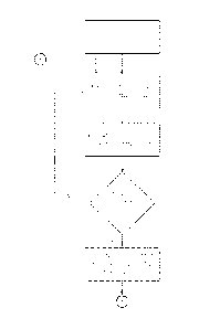
[00020] Figures lla and 1 lb together are a flowchart illustrating an method
in accordance
with an embodiment.
DETAILED DESCRIPTION
[00021] In accordance with an embodiment of the present invention, a method
for inverting
seismic data includes providing information regarding an expected geological
structure, and
inverting that structure to determine what velocity models would produce the
given structure. As
will be appreciated, velocity models in this context may be isotropic or
anisotropic, depending,
for example, on the geology of the region under study or on simplifying
assumptions made in the
modeling. In general, such modeling is performed on a computing system
including a processor,
a graphical user interface, and a data storage device.
3
[00022] After completing the inversion, gathers are checked for flatness.
Along with the
interpretive input that delineates the expected structure, regions are
identified where there is
reason to believe that velocities might be incorrect and therefore eligible
for change during the
inversion.
[00023] Figure 1 is an example of a seismic image to be displayed that
includes an apparently
anomalous feature. Specifically, there is a depressed region indicated by the
white oval that does
not appear to be a geologically likely. Typically, an expert interpreter would
tend to believe that
the reflection should be smoother and flatter.
[00024] Thus, this region of the image would appear to be an artifact that may
be caused, for
example, by an incorrect velocity model. Specifically in this case, it appears
that a portion of the
overburden has been assumed to have higher velocities than are actually
present (resulting in the
greater imaged depths for this portion of the structure). In a particular
example, the interpreter
may know or expect that some portion of the overburden should be
heterogeneous, or might be
aware that the uncertainty of the velocities in this region are highly
uncertain for some reason.
[000251 In some cases, it may be difficult to improve the velocity modeling
in this difficult
region. For example, in a region for which there is limited effective offset
and no deeper events
to use for velocity correction (as depicted in Figure 2), conventional gather
flattening approaches
may not be able to provide sufficient basis for correction.
[00026] In a method in accordance with an embodiment of the invention,
characteristics (e.g.,
location, dip) of an erroneous structure, or a structure perceived to be
erroneous, are identified.
In an embodiment, the identification is made by using interactive 3D graphics
to place markers,
for example, disks, at the location and dip of the structure in question as
shown in Figure 3. In
principle, the marker may be similar to or the same as what is known to those
in the art as a dip-
bar, a name that is retained from 2D seismic work, for which location and dip
can be represented
by a simple line segment or bar.
[00027] The method may be useful, for example, in a seismic ray-tracing
migration method
(for example a Gaussian-beam migration method as described, for example in
U.S. Pat. No.
5,274,605). It may also find application in other migrations, including, for
example, Kirchhoff,
RTM and others. In accordance with such a ray-tracing embodiment, a normal ray
from the
center of the disk is plotted, directed upward to the earth's
4
CA 2876632 2018-09-26
CA 02876632 2014-12-12
WO 2014/018132 PCT/US2013/036206
surface. Once a disk is placed on a currently imaged event, the next step is
to identify what the
correct structural position of this event is believed to be. The
identification of this corrected
position is made by specifying a shift along the normal ray as illustrated by
the arrow in Figure 4.
The designation of dip bars and their respective shifts and normal rays is
repeated over the
structure until the entire structure is defined as shown in Figure 5.
[00028] For a given set of dip bars and their associated structural changes,
there are generally
a large number of potential velocity fields that could be responsible. The
seismic rays generated
by the dip bar placement may be nearly parallel, implying that there is little
resolution for
corrections along the normal direction (along the rays). Therefore, an
interpretive step is
optionally included to provide additional resolution in this direction.
[00029] Just as the interpreter usually has a notion of what the correct
geological structure
should be, he or she usually has an idea of where the velocities are most
uncertain and therefore
most likely in need of update. For example, where the problematic structure is
the result of
shadowing by a fault, an experienced interpreter will tend to understand that
the velocity field has
large uncertainty near the fault.
[00030] In this example, uncertainty may result, in part due to contrasts in
bedding across the
fault or because of gas trapped near the fault, either one of which causes a
lack of uniformity of
velocities in the region. Such velocity heterogeneity near the fault is often
beyond the
capabilities of conventional velocity analysis methods and generally remains
uncertain when the
interpreter is trying to resolve fault shadows. Therefore, it is reasonable in
the case of the fault
shadow to provide the needed resolution by limiting the velocity updates to
the region near the
fault.
[00031] As will be appreciated, there are a variety of structures that an
interpreter may identify
as likely to result in uncertainties from which spatial resolution for
velocity changes may be
derived. By way of non-limiting example, such uncertainty-producing structures
include: gas
pods, allochthonous sediment layers near allochthonous salt, salt inclusions
of anhydrites or
sediments, complex salt-sediment interfaces and rocks near sea-floor canyons.
In these and
many other cases, the interpreter can identify the regions of velocity
uncertainty on an existing
image but does not know what the magnitude of the corrections should be.
CA 02876632 2014-12-12
WO 2014/018132 PCT/US2013/036206
[00032] In accordance with an embodiment of the invention, the uncertain
magnitudes may be
provided by performing an inversion on the dip bar shifts.
[00033] Once a set of dip bars and their shifts have been selected, the
process for carrying out
the inversion begins by creating a three-dimensional grid that spans a space
representing a
velocity model for a subsurface region. As will be appreciated, it may
analogously be applied to
two dimensional planes as well as 3D spaces. As is illustrated in Fig 6,
graphics software is
provided to position a grid over a region of an existing seismic image. By way
of example,
GOCAD, available from Paradigm, may be used in an embodiment. In another
embodiment,
Open Inventor, an open-source three dimensional graphics library may be used.
[00034] The grid may be used to store the velocity changes that result from
the dip bar
inversion. In this approach, each node of the grid contains an inverted
velocity change at the
spatial position of the node. Between nodes, velocity changes can be
interpolated based on near
neighbors. For example, a trilinear interpolation method may be used, though
in principle other
spatial interpolations (e.g., tricubic, are available. These values are viewed
on a translucent
color scale (represented in gray-scale in Fig 6) and are typically
superimposed on coincident
gray-scale plots of the seismic image. The velocity being viewed may be the
changes in velocity
resulting from the dip-bar inversion or the total velocity (which is the sum
of the original velocity
value and the value on the grid).
[00035] A masking technique may be used to identify and/or isolate regions of
velocity
uncertainty within the space. In this way, the computations may be restricted
by allowing
velocity updates only within the regions where uncertainty is expected. The
other, unmasked
volumes are not updated.
[00036] Values for the mask may be stored on the same three-dimensional grid
that is used to
store the calculated changes resulting from the dip-bar inversion. The masked
volumes may be
specified in accordance with a number of embodiments, and embodiments may be
combined
within a single model. By way of example, the volumes may be specified as
layers within an
earth model, as regions near intersections of surfaces within a model, or
painted with a three-
dimensional brush.
[00037] Figure 7 shows an example of a two-dimensional slice through a masked
region above
a dip bar and an associated displaced dip bar and proposed shift value. A mask
value of 1 (dark
6
CA 02876632 2014-12-12
WO 2014/018132 PCT/US2013/036206
grey) indicates where the velocities may be changed and a value of 0 (white)
indicates where the
velocities may not be changed. In an embodiment, the masked region may be
feathered at its
edges such that there are taper regions with mask values between 0 and 1. In
this region, the
velocities may be changed, but the changes are constrained in accordance with
systematic rules.
Complex masks can be constructed from combinations of individual simple masks.
For example,
a grid might be masked if it is within the mask of a surface A and a surface
B; or it might be
masked if it is within the mask of a surface A or a surface B (which may be
the disjunctive or the
exclusive disjunctive) .
[00038] Once the structural corrections have been delineated with dip bars and
the region
eligible for velocity corrections has been identified by a mask, the method
proceeds by
determining what velocity changes within the masked region can best produce
the necessary
structural corrections. These changes are automatically determined in
accordance with the
method by optimizing a set of equations. Specifically, for each ray there is
an equation that
states that the changes in velocities should shift the dip-bar for that ray by
an amount needed for
the new desired structure:
/0 = Asi = S, = Adõ (1)
J=1
where Asj is the slowness change in cell j, and where slowness is defined as
the reciprocal of
velocity, /Li is the length of the ith ray in the jth cell, S, is the slowness
at the location of the ith
dip bar, Ad, is the distance for the structural correction at the ith dip bar,
and M is the number of
cells. Most values of / are zero because the ith ray does not pass through
most cells. The
penalty for not satisfying equation (1) is quantified as
- 2
N V/
= As, ¨Si = Ad,
i=1 - _ J=1 (2)
where N is the number of rays. Also, changing the slowness in regions where
the mask is being
tapered to zero is penalized. The penalty is:
7
CA 02876632 2014-12-12
WO 2014/018132 PCT/US2013/036206
(3)
i=t
for all j, where in, is the mask value in the jth cell, and M is the number of
cells in the inversion.
Roughness is also penalized in the x, y, and z directions:
4/
P =1ZI 2
=
P = I(As(v) ¨ As.7)2
y 2 (4)
J=1
ir
iz(Asjiz) Asj)2
>=1
for all j, where A.s,(x) ,A4Y) , and As are the slowness change in the
neighboring cells in the
positive x, y and z directions. The total penalty is
P = + + wPx + + w zPz
(5)
[00039] w w w 142.,
where m, x, and are weights on the penalties for the mask and
smoothness
in three directions.
[00040] Finding the slowness changes that minimize P (equation 5) generates
a linear system,
which may be solved by a number of methods. In an embodiment, the system is
solved in a
hybrid L1/1,2 sense using iteratively reweighted least squares.
[00041] Figure 8 shows the results of an inversion for a single dip bar and
mask as shown in
Figure 7. In this case, the inversion finds smooth velocity changes along the
ray (indicated by
the darker grey region extending above the dip bar) which would produce the
depth shift
indicated for the dip bar that was set as the determined structural change. As
may be seen, the
velocity model is altered only in the band of the mask, in this case the mask
functioning to
delimit a top and bottom of the velocity model changes.
[00042] In a typical case, as noted above, a number of dip bars would be
necessary to indicate
the determined structural changes necessary to correct an image. An example of
such a situation
is illustrated in Figure 9, corresponding to a fault-shadow situation.
8
CA 02876632 2014-12-12
WO 2014/018132 PCT/US2013/036206
[00043] For the example of Figure 9, a set of dip bars is selected to map out
the structural
distortions and corrections that are interpreted to be in the fault footwalls.
The interpreter also
defines a mask to ensure that calculated velocity changes are applied only
near the faults and in
the footwalls ¨ regions determined likely to have high uncertainty.
[00044] In accordance with the method described above, an inversion with
smoothing
constraints is performed to find an updated velocity model. Finally, the
updated velocity model
is used to compute an updated image.
[00045] Images computed for the initial velocity model and for the updated
velocity model are
shown in Figures 10a and 1 Ob. In the updated image, the structure in the
footwall is relatively
simplified, and appears more like what would be expected by the interpreter.
Likewise, artifacts
such as vertical streaks in amplitude are removed. The removal of such
artifacts can be taken as
evidence that the updated velocity model is more likely to be accurate. In an
embodiment, image
gathers may be inspected to determine whether events are flattened in the
updated image as
compared to the initial image. Improved flattening could be taken as a sign
that the updated
velocity model is a more accurate depiction of the subsurface structure.
[00046] Figures lla and 1 lb are a flowchart illustration of an inversion
method in accordance
with the present invention. The method begins with identification of a
distorted image location
by assigning a dip bar location. A correction is then added to the location.
If the image
correction has been delineated, then the method proceeds to identification of
portions of the
model where velocities might be changed (e.g., masking). If not, then
additional distorted image
locations are identified and corrected.
[00047] The flowchart proceeds to Figure 1 lb and choosing smoothing
constraints. The
resulting locations, corrections, masking and smoothing constraints are
applied to produce
equations to be optimized. The equations are solved to produce an updated
velocity model.
Based on the updated velocity model, an updated image is produced by
remigration. If the
resulting image gathers are satisfactory, then the method is complete,
otherwise, it proceeds
along the path A back to identifying distorted image locations.
[00048] As will be appreciated, each step in this process may in principle
require only
moderate computer power. In a typical case, the interpretive step of placing
the dip-bars can
involve significant time and effort.
9
CA 02876632 2014-12-12
WO 2014/018132 PCT/US2013/036206
[00049] Because of the relatively low computational cost of a ray tracing
approach,
preliminary placements of the dip-bars can be quick tested to see if the
inversion gives a
reasonable velocity change. In this regard, a reasonable change can be one
that produces the
desired shift in dip bars, and that is also relatively smooth. As a result,
the method may be retried
with different sets of dip bar placements and with different smoothing
constraints until an
interpreter is satisfied with the result.
[00050] As will be appreciated, the method as described herein may be
performed using a
computing system having machine executable instructions stored on a tangible
medium. The
instructions are executable to perform each portion of the method, either
autonomously, or with
the assistance of input from an operator. In an embodiment, the system
includes structures for
allowing input and output of data, and a display that is configured and
arranged to display the
intermediate and/or final products of the process steps. A method in
accordance with an
embodiment may include an automated selection of a location for exploitation
and/or exploratory
drilling for hydrocarbon resources. Where the term processor is used, it
should be understood to
be applicable to multi-processor systems and/or distributed computing systems.
[00051] While the method is described primarily in terms of isotropic
velocities and slowness,
it should be understood that it may be employed in the context of anisotropic
velocities and
models thereof. By way of example, the slowness changes along the direction of
the raypath may
be specified by parameters for vertical transverse isotropy, such as those
described by Alkhalifah
and Tsvankin (1995). Additionally, the proposed method may be modified to
reshape earth-
model surfaces that represent geological boundaries between layers having
contrasting velocities,
such as surfaces that represent salt-sediment boundaries.
[00052] Those skilled in the art will appreciate that the disclosed
embodiments described
herein are by way of example only, and that numerous variations will exist.
The invention is
limited only by the claims, which encompass the embodiments described herein
as well as
variants apparent to those skilled in the art. In addition, it should be
appreciated that structural
features or method steps shown or described in any one embodiment herein can
be used in other
embodiments as well.