Note: Descriptions are shown in the official language in which they were submitted.
CA 02879806 2016-06-27
1
DOWN-HOLE MONITORING AND SURVEY SYSTEM
Field of the Invention
This invention relates to the equipment and system used to perform drill-hole
survey
and geological surveys of the sub-surface of earth, either onshore or
offshore, wherein
the equipment is given access to the subterranean strata by way of pre-
prepared
exploratory drill-holes.
Background of the Invention
Geological surveys are critical activities used by mining and resource
companies to
determine the viability and operation of mines and wells. The accuracy and
timeliness of the acquired data is an important factor in finding the next big
ore
deposit, or oil or gas well. When it comes to geological surveying, time and
precision
are critical factors. Cost is an important factor as well. Lower cost surveys
allow an
operator to conduct more surveys within a set survey budget for a particular
site.
It is common practice that a series of drill-holes are created so that
professional
geoscientists, such as geologists can use a variety of equipment and survey
technology
and techniques to get as much data as physically possible that relates to the
subterranean strata deep within the Earth's crust at that location.
One of the problems associated with the practice is that these geological
surveys are
typically slow and costly to perform. The common practice is to have an on-
site a
drilling team that performs the drilling operation and creates the drill-hole,
and then
there is a survey team that subsequently works on the drill-hole with their
equipment
and performs the necessary geological survey. The survey team then returns to
their
office with their collected data and start processing it to generate a survey
report that
mining or resource companies use to guide the planning and decision making
relating
to the operation of an existing asset, or the creation of a whole new
operation.
CA 02879806 2016-06-27
2
Another problem associated with the common practice is that the tools and
equipment
used by the survey team are often highly specialised and complex, often
requiring
significant training and years of experience to operate correctly and
effectively. In
addition, the equipment is often expensive to maintain. Also there is
currently only
limited access to real-time data produced by the survey. Often this data is
not
analysed for days, weeks or months after the survey has been performed.
Ideally it would be best if the professional survey personnel were able to
remain at the
lo place where they are able to analyse and collate the survey data
acquired as soon as
possible after the survey operation has been completed and the data has been
obtained.
Another problem is that drillers usually maintain a paper log of drill site
activity, and
this adds delays to the processing times of the geological survey data, and
also adds
delays to the processing of payments to the drillers for their work, and has
the
potential of introducing human error into the log.
Also geological survey personnel such as geologists often take an ad-hoc
approach to
the storage of the acquired geological survey data.
Due to the complexity and specialization of skills needed to effectively use
the tools
and equipment to conduct the survey, it is often not possible to have the
drill
operators perform the geological survey of a high and known quality, in
addition to
creating the drill-hole.
It is an object of the present invention to at least ameliorate some or all of
the
aforementioned problems.
CA 02879806 2016-06-27
3
Disclosure of the Invention
The present invention is a drill-hole survey and geoscientific data
acquisition system
that includes a down-hole tool including:
- a sensor control module,
at least one sensor module, and
data, control and electrical power connection means,
wherein the sensor control module, the at least one sensor module, and the
connection
means are each sized and shaped so that they can be placed within a drill-hole
and can
travel along the length of the drill-hole, and can travel along the drill-
hole. the sensor
control module is a discreet control module, and each of said at least one
sensor
modules are also each a discreet sensor module, and each of the discreet
control and
sensor modules are inter-connectable via said data, control and electrical
power
connection means so that the series of modules are connected end to end to
make one
continuous elongate tool that contains a series of interconnected modules. The
sensor
control module controls the tool and provides electrical power to, and sends
control
signals to, and receives data from, each of the at least one sensor module.
The tool
collects data along the drill-hole.
Preferably the tool collects geoscience data at discreet places along the
drill-hole
when the tool is stopped.
Alternatively the tool continuously collects geoscience data as the tool
travels along
the drill-hole.
Preferably the tool includes data transmission means that sends data up to the
operator
at the ground surface, and said transmission means is either wired or
wireless.
Preferably the tool includes two wireless communication modes, one that is
high
powered, and the other that is low powered, and only one or the other is
typically in
operation at any one time.
CA 02879806 2016-06-27
4
Preferably the high powered mode is used to transfer a large amount of data as
quickly as possible, such as firmware upgrades to the modules, and/or large
amounts
of sensor data, and is subsequently switched off when no longer required to
preserve
the tool's battery power reserves.
Preferably the low powered wireless communications mode is used to send short
quick commands back and forth from the tool, and when only small amounts of
data
need to be transferred.
Preferably the tool is capable of self-determining which wireless
communication
mode to use for any particular data transfer task, or the operator can
manually select
the wireless communication mode using remote commands.
Preferably the tool is capable of continuously transmitting said geoscience
data back
to the operator while the tool is down the drill-hole.
Alternatively the geoscience data can be collected and stored within the tool,
and this
collected data can then be uploaded into a handset by an operator after the
tool has
been retrieved from the drill-hole.
Preferably at least one gyroscope is included inside a discrete gyroscope
module that
is connected to, and forms a part of the elongate tool.
Alternatively at least one gyroscope is incorporated into the sensor control
module.
Preferably the gyroscope is a microelectromechanical type gyroscope, also
known as a
MEMs gyroscope.
Preferably the gyroscope module includes four gyroscopes, and these are
installed
"nose to tail" so that the length of the gyroscope module is minimised.
Preferably each sensor module includes one or more types of sensor technology.
CA 02879806 2016-06-27
Typical sensor types used within a discrete sensor module include, but are not
limited
to:
a. magnetic induction sensing, or
5 b. gamma ray sensing, or
c. electrical resistance sensing, or
d. acoustics sensing, or
e. video surveillance, or
f. temperature sensing, or
g. gravity gradiometer, or
h. pressure sensing.
The down-hole tool is capable of being transported to the drill-hole site by
the drilling
operators in a disassembled condition, and the tool is capable of being
assembled on-
site and accurately calibrated so that the tool includes all the appropriate
modules
required for any particular geoscientific survey to be performed on a
particular drill-
hole.
Preferably the tool can be disassembled and safely stored after the survey
operation
has been completed by the drilling operators, ready to be transported to the
next
survey site.
Preferably the discrete modules are screwed together to form the elongate
tool.
Preferably the sensor control module has the data transmission means at its
end
nearest to the opening of the drill-hole, and has data, control and electrical
power
connection means at the other.
Preferably each of the sensor modules and the gyroscope module has data,
control and
electrical power connection means at each end, and when each discrete module
is
screwed together with a neighbouring module, the data, control and electrical
power
connection is made between each module that makes up the tool.
CA 02879806 2016-06-27
6
Preferably the connection means includes an array of spring loaded electrical
connector pins at one end, and a plurality of discrete electrical contacts at
the other, so
that when two modules are screwed together, the spring loaded pins of one
module
are forced into electrical contact with a desired electrical contact on its
neighbouring
module.
Preferably each module includes a data logger that is relevant to that
particular
module.
to
Preferably each module includes the capability of shutting down power to its
neighbouring module to preserve its own operational integrity.
Preferably the sensor control module includes a temperature sensor for the
tool.
Preferably the sensor control module includes a tamper sensor that indicates
if any of
the modules have been tampered with.
Alternatively each of the modules that makes up the tool includes a tamper
sensor that
indicates if the particular module has been tampered with.
Preferably the tool is capable of processing the data acquired by the sensors
within the
tool, so that the amount of data that is stored within the tool and
transferred or
transmitted from the tool is minimised.
Optionally at least one of the modules is filled with a suitable material such
as oil to
dampen the rate of variations in temperature which may adversely affect the
efficacy
or accuracy of the particular sensor.
Optionally the tool, including each module, and/or ancillary equipment, such
as the
handset, and/or associated software, includes digital rights management
technology
that can be remotely enabled or disabled by an authorised third party, such as
a
CA 02879806 2016-06-27
7
distributor and/or owner of the tool, and wherein the tool, including each
module,
and/or ancillary equipment such as the handset, and/or associated software,
can only
be operated when the digital rights management technology is enabled.
In another form, the present invention is a down-hole survey system that uses
the
down-hole tool that has been previously described, and includes:
- a tool controller,
an access point,
- at least one server, and
- a plurality of computers,
wherein the tool controller and the access point are located in the vicinity
of the drill-
hole. The tool controller is used to operate the tool, and collect the
geophysical data
acquired by the tool. This data is sent to the access point, and the access
point is
capable of wirelessly transmitting the acquired data over a wide area network,
such as
the internet, to the at least one server and plurality of computers.
Preferably the tool controller is a ruggedised handset.
Preferably the access point is capable of creating a gateway between the local
area
network at the survey site, and a wide area network, such as the internet, so
that data
to/from the down-hole tool, and/or to/from the handset, and/or to/from the at
least one
server, and/or to/from any one of the plurality of computers, passes via the
gateway.
Optionally the access point is integrated into the ruggedized handset so that
the
handset is capable of functioning as both the tool controller and the access
point.
The present invention includes the arrangement where both the at least one
server and
at least one computer are geographically remote from the survey site.
Preferably the at least one server and the at least one computer in the
plurality of
computers are located within a master control facility, and at least one of
the plurality
of computers is located in a separate office remote from the master control
facility.
CA 02879806 2016-06-27
8
Preferably the master control facility, both in conjunction with, or
independently of,
the separate office, prepares and dispatches a drilling program to a driller
onsite, who
will compare instrument data with a planned drill-hole plan so that the
driller can
make any last minute adjustments to the drilling program.
Preferably the master control facility, either in conjunction with, or
independently of,
the separate office, is capable of using the survey data it receives from the
survey site
so that the drilling program and drill-holes can be analyzed.
l0
Preferably the handset is capable of acquiring and transmitting data relating
to the
operational status and condition of the tool so that either or both the
operator at the
drill-hole site or the professional personnel at the master control facility
are alerted
if/when critical aspects of the tool has fallen out of proper calibration, or
has in some
other way moved outside of acceptable operational parameters for the
particular
survey operation being undertaken.
Preferably personnel at the master control facility can react to alerts
relating to critical
aspects of the tool falling out of proper calibration, or in some other way
has moved
outside of acceptable operational parameters for a particular survey
operation, by
sending corrective and/or instructional data back to the drill site, including
firmware
for the hardware, and/or updated associated software, in order to attempt to
get the
tool, or an included module within the tool, back into proper calibration,
and/or back
to within acceptable operational parameters for that particular survey
operation being
undertaken, or to upgrade the equipment so that it operates at peak
efficiency.
Preferably an authorised third party, such as a distributor and/or owner of
the tool,
including each module, and/or ancillary equipment such as the handset, and/or
associated software, can enable or disable the digital rights management
technology
associated with that equipment and associated software, depending on the
licence
status of the operator at the time that the operator is preparing to use the
equipment
and/or associated software to perform a survey on a drill-hole.
CA 02879806 2016-06-27
9
Preferably the handset has a simplified user interface that enables and
empowers a
driller at the survey site to perform highly specialised and complex survey
activities
under the supervision and instruction of professional geological survey
experts, such
5 as geologists, located at the master control facility, or at a remote
office, thereby
giving the professional survey experts virtual access to the drill site and
remote
oversight of the survey operation for any particular drill-hole survey
operation being
undertaken.
to Brief Description of the Drawings
Figure 1 is an exploded isometric view of a tool having a control module, a
gyroscope
module and a sensor module.
15 Figure 2 is an isometric view of the electrical power, control and data
connection
means.
Figure 3 is a side cut away view of the gyroscope module showing four
gyroscopes
installed.
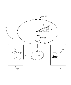
Figure 4 is a schematic of the complete survey system including the tool.
Detailed Description of the Preferred Embodiments
25 Turning firstly to Figure 1 we see an exploded view of the down-hole
survey tool 1.
= The survey tool 1 can be assembled from a sensor control module 3 and a
gyroscope
module 13, and a plurality of sensor modules, selected from a kit containing a
wide
variety of sensor module types. Starting with the sensor control module 3,
typically
the gyroscope module 13 is connected to the sensor control module 3 via the
external
30 and internal screw thread pair 5 and 7 respectively. Each module has
matching
internal and external screw threads, thereby enabling the tool to be assembled
in a
CA 02879806 2016-06-27
wide variety of configurations. A different selection of sensor modules are
assembled
together for each specific survey task.
The sensor control module 3 is the master controller for the device. It
includes the
5 power supply for the tool, as well as the controller and monitoring means
for each
other module in the tool assembly. In addition, the sensor control module 3
includes
data receiving and transmitting means. An example of suitable means is the
wireless
data receiving/transition means 11. As an alternative to wireless means, the
sensor
control module could also communicate with the ground surface via a wire.
In another preferred embodiment, the tool may incorporate two wireless
communication modes. The first is a high power mode that is capable of sending
and
receiving comparatively large amounts of data more quickly and effectively.
The
other mode is a low power mode, and this mode is suitable for small amounts of
data
transfer. Typically only one mode is in operation at any one time. Because the
high
power mode consumes more power from the battery power reserves for the tool,
it is
only switched on when needed, and at other times it is turned off. The tool is
capable
of self-determining which mode it needs to use based on a variety of factors,
such as
the amount of data to be transferred, and/or whether there is enough power in
the
battery to be able to be used. In addition to this, either the driller, or a
remote
operator can remotely command the tool to use one mode or the other.
The end of the sensor control module 3 furthest from the opening of the drill-
hole
includes a set of electrical contact rails. When a module is screwed onto the
sensor
control module, and electrical connection is made between them. This
electrical
connection permits the flow of data, electrical power and control signals
throughout
the tool.
Within the scope of the present invention, the sensor control module may also
include
one or more gyroscopes. In this embodiment, there is no need to have a
separate
gyroscope module 13. In another embodiment, the sensor control module 3 may
also
include a sensor, such as a temperature sensor, thereby removing the need for
CA 02879806 2016-06-27
11
including a temperature sensing module in the tool. In yet another embodiment,
the
sensor control module 3 may include a tamper alert sensor that is capable of
alerting
the operator or owner of the tool to an unauthorised tamper event on any of
the
modules of the tool.
In another embodiment, some or all the modules include a respective tamper
alert
sensor that alerts the operator or owner of the tool of an unauthorized tamper
event on
any of the respective modules of the tool.
Each sensor module 15 is capable of doing at least one specific sensor or
survey task,
including, but not limited to:
= magnetic induction sensing
= gamma ray sensing
= electrical resistance sensing
= acoustics sensing
= video surveillance
= temperature sensing
= gravity gradiometer
= pressure sensing
Each sensor module may operate either autonomously, or may be controlled by
the
control module. Sensor data collected by a particular sensor module may either
be
stored locally in that particular sensor module, or the data may be stored in
the control
module, or a combination of both for the sake of redundancy.
Each module within the tool 1 includes a data logger.
Turning to Figure 2, we are shown opposite ends of a sensor module. We can see
that
there is an array of multiple spring loaded connector pins 17 at one end, and
a
plurality of concentric electrical contact rails 19 at the other. When two
modules are
screwed together, the spring loaded connector pins are forced into electrical
contact
with the electrical contact rails 19. Depending on the requirements for that
particular
CA 02879806 2016-06-27
12
module, the pins 17 are arrayed so that only the appropriate contact rails 19
are
connected to.
When the tool is assembled, it becomes a rigid elongate tool that is
dimensioned to be
lowered down the drill-hole. In another form of the invention, small bendable
connectors are located between each module, thereby allowing individual
modules to
bend with respect to its neighbor. This assists in special circumstances where
the tool
needs to pass around a bend in the drill-hole that is would otherwise not be
capable of
passing in its rigid form.
Turning to Figure 3 we can see a cut away side view of the gyroscope module
13. In
this embodiment we can see that is includes four MEMs type gyroscopes. The
internals for the entire gyroscope module are capable of turning under the
influence of
a motor. The internals of the module are connected at each end to the bearings
23.
The more gyroscopes that are installed in the tool thereby gives the tool a
capability to
reach an acceptable level of directional orientation precision in a shorter
period of
time, compared to a tool with fewer gyroscopes installed.
In a preferred embodiment, up to four MEMs gyroscopes are used inside the
gyroscope module, and these are installed in a "nose to tail" configuration so
that the
length of the gyroscope module is considerably reduced.
ln an alternative embodiment, it is possible that some, or all of the
individual modules
used in the tool are filled with a suitable substance, such as an oil, so as
to dampen the
rate at which temperature varies within the tool. Some efficacy and/or
accuracy of
some types of tools is degraded if it is subjected to temperature variations.
Turning to Figure 4 we are shown a schematic of the down-hole survey system 25
that
uses the down-hole tool 1 as previously described. The system includes the
down-
hole survey tool I, a handset 27, an access point 29, at least one server 31.
The access
point 29 acts as a gateway between the local area network 35, and the wide
area
network, such as the internet, that connects to the remote server 31 and the
computer
CA 02879806 2016-06-27
13
33. In a preferred embodiment, the server 31 is remotely located from both the
survey
site and the computer 33. Preferably the server is located inside a Master
Control
Facility 37 that can be physically located anywhere in the world. The computer
33 is
located at a client survey office 39, also located anywhere in the world.
Geophysical
scientists, such as geologists can be located at either facility and can
oversee and run
survey remotely from the survey site. There is a high degree to communications
flexibility designed within the system. The down-hole tool 1 is can be
configured to
communicate directly with the access point 29, or via the handset 27 to the
access
point, and also it can be configured to communicate directly with the computer
33 or
the server 31.
Additionally the master control facility 37 can monitor and maintain the
equipment at
the survey site in real time. If the module issues an alert that one or more
of the
modules have gone out of acceptable operational limits, the master control
facility 37
can send back corrective instructions to the tool, and/or send instructions to
the
drilling operator about how to correct the problem.
The master control facility 37 enables the geophysical professionals to
remotely plan
and control the drilling program for the client at a particular survey site.
At the
commencement of a survey, the survey plan would be sent via the wide area
network
link to the handset and down-hole tools onsite. The handset, or in some cases
a laptop
computer or tablet that is being used by the driller will compare the
instrument data
with the planned survey data and provide guidance to the driller on parameters
such
as actual drill-hole deviation from planned direction to suit the specific
geology of the
survey location. A client company, such as a geoscience laboratory, at their
office 39,
can also enter in assay or other relevant information into the server records
relating to
the particular survey.
Furthermore, the master control facility can perform analytics based on the
geo-
location of the survey and the theoretical accuracy of the down-hole tool
based on its
location on the earth can be accounted for. This is required because
Gyroscopic based
sensors change accuracy depending on the latitude at which they are used,
while
CA 02879806 2016-06-27
14
Magnetics tools require declination corrections to calculate true north
depending on
the latitude and longitude.
The other main aspect of the invention is that a user, such as a drilling
contractor, or a
mine site, can create a local area geophysical data network in a region by
installing an
access point 29 and that allows the down-hole tool and/or handset to directly
and
wirelessly communicate with both the master control facility's server, and/or
client
survey office 39.
In another form of the present invention, the access point 29 is incorporated
into the
handset, so that the handset also performs the function of the access point.
Another important aspect of the invention is that down-hole tool 1 undertakes
the
majority of the sensor data processing and thereby reduces the amount of data
that
needs to be transferred to the handset. This reduces the processing required
on the
handset, and reduces the amount of data to be transmitted to the handset from
the
instrument, and to the master control facility server 31. For the user at the
survey site,
it offers them a simple handset which is very easy to use, and requires
minimal
training, thereby allowing a drilling contractor to also perform the physical
operations
required to perform the survey.
Another important aspect of the invention is that the owner and/or distributor
of the
tool, ancillary equipment, and associated software, can remotely upgrade or
service it
as required so that the tool and its ancillary equipment and associated
software can
function at peak efficiency. Upgrades include updated software, or firmware
for
relevant hardware used either in or associated with the tool.
In another aspect of the invention, at least some of the modules, and/or the
ancillary
equipment such as the handset, and any associated software, has digital rights
management technology incorporated with it. When the digital rights management
technology is activated, the tool, and ancillary equipment, is in a usable
condition.
When the digital rights management technology is disabled, the tool and/or
ancillary
CA 02879806 2016-06-27
equipment is in a non-usable condition. Furthermore the distributor and/or
owner of
the tool is able to remotely enable or disable the digital rights management
technology. This arrangement thereby enables the distributor and/or the owner
of the
tool and ancillary equipment to lease/rent out the equipment to an operator
and ensure
5 that it can only be used when the operator is in compliance with their
relevant
lease/rental agreement.
There are also other significant advantages to the system of the present
invention.
Under current practice, drillers maintain a paper log of drill site activity.
This manual
10 process introduces delay into the processing and payment times for the
field services
they have provided. Under this system, payments to the drillers for their
field services
can be processed much quicker.
Finally, by having the data collected by the tool sent directly from the drill-
site to the
15 remote office, the integrity and security of the data kept more secure.
The scope of the claims should not be limited by the preferred embodiments set
forth
in the examples, but should be given the broadest interpretation consistent
with the
description as a whole.
It will be also understood that where the word "comprise", and variations such
as
"comprises" and "comprising", are used in this specification, unless the
context
requires otherwise such use is intended to imply the inclusion of a stated
feature or
features but is not to be taken as excluding the presence of other feature or
features.
The reference to any prior art in this specification is not, and should not be
taken as,
an acknowledgment or any form of suggestion that such prior art forms part of
the
common general knowledge in Australia.