Note: Descriptions are shown in the official language in which they were submitted.
CA 02880686 2015-01-30
WO 2014/020315 PCT/GB2013/051989
- 1 -
Detecting Moving Vehicles
The present invention relates to detecting moving vehicles.
The growth in Uninhabited Air Systems (UAS) and a desire for their
routine use in place of manned aircraft for common operational missions is
presenting a major technology and regulatory challenge to the aerospace
industry. A number of new technology areas need significant development and
validation to provide the UAS with the equivalent functionality needed to
replace
the human pilot's role in ensuring safe operation.
Current medium/large UAS (>150Kg) operation requires strict
segregation from other airspace users or burdensome additional safety
measures such as a chase aircraft. For example, in the UK it has been
mandated that an approved method of aerial collision avoidance is required
and, therefore, UAS operations will not be permitted in the United Kingdom in
non-segregated airspace, outside the direct unaided visual line-of-sight of
the
pilot, without an acceptable sense and avoid system. UAS technology and
generation of a regulatory consensus on its certification and acceptance
require
significant progress to overcome barriers to the goal of unrestricted access
to
National Airspace Systems (NAS) alongside conventional air traffic.
Emerging UAS regulations are based on the principle that UAS
operations should be of an equivalent level of safety to current manned
aircraft
operations and transparent to all existing users of NAS. This means that UAS
operations should not introduce any greater risk to other airspace users than
currently exists and also that UAS should be able to be handled in the same
way as current manned aircraft by all airspace participants.
CA 02880686 2015-01-30
WO 2014/020315 PCT/GB2013/051989
- 2 -
The underlying principle of UAS equivalence in emerging regulations for
unrestricted UAS airspace access is particularly relevant to the key
technology
area of collision avoidance systems for UAS (commonly referred to as 'Sense
and Avoid' or Detect and Avoid'). A cornerstone of aviation safety has always
been the function of the pilot to avoid collisions by looking through the
window
of the aircraft. 'See and Avoid' refers to the process whereby "vigilance
shall be
maintained by each person operating an aircraft so as to see and avoid other
aircraft". A baseline requirement for UAS collision avoidance is that a UAS
Sense and Avoid system must provide, at least, "a capability and level of
safety
which is equivalent to the existing 'see and avoid' concept". The provision of
a
functional equivalence to this 'see and avoid' capability has become one of
the
more formidable barriers to entry into the National Airspace System for
unmanned aircraft systems.
Future mandates in Europe and the United States for Automatic
Dependent Surveillance Broadcast (ADS-B) equipage for most aircraft will
mean that increasingly, aircraft will 'co-operate with UAS collision avoidance
systems by regularly broadcasting their Global Positioning System (GPS)
position. Reliance on such cooperation alone is unlikely to achieve the
required
level of safety due to a lack of total equipment equipage coverage, inherent
security weaknesses, variable performance, and inevitable equipment
malfunctions. Additionally there will always be the requirement for the
detection
of `non-cooperative' traffic, such as gliders, hot air balloons, and aircraft
where
position broadcast has failed. It is also expected that a single sensor
solution
will not meet the integrity requirements for a safety critical application and
that a
CA 02880686 2015-01-30
WO 2014/020315 PCT/GB2013/051989
- 3 -
multi dissimilar sensor approach will be required to provide a form validation
for
sensor measurements.
A key requirement for the perfect aircraft detection algorithm is to detect
an aircraft as soon as the sensor can resolve it. This produces the situation
where high resolution cameras are frequently used to sense aircraft that
initially
appear in the image at a low resolution. This makes the efficient and robust
estimation of the position or appearance of aircraft using image processing
techniques difficult. These challenges are continuously being addressed,
motivating much of the research in this problem area.
A common approach for detecting aircraft on a collision path is to use the
contrast ratio between the target and background. This is based on the
observation that the aircraft will appear either brighter or darker than its
background. Grey-level morphology algorithms are used to detect the local
peaks in contrast. Typically, the binarised outputs from a top and bottom hat
filter are used to generate detections for downstream algorithms.
Unfortunately, these approaches assume that aircraft during flight are of
high contrast and maintain a constant dark or bright intensity. They also
assume that a single structured morphology element with specified orientation,
size and shape is suitably generic for detecting all aircraft from all
distances and
angles. Furthermore, it is well-known that morphology techniques are
computationally intensive requiring parallelised implementation or dedicated
hardware to meet real-time requirements. Finally, morphology approaches are
noted as returning a large number of false positives with computationally
intensive techniques used to post-process the detections. In general, many of
CA 02880686 2015-01-30
WO 2014/020315 PCT/GB2013/051989
- 4 -
the known proposed solutions require many parameters hindering deployment
on unmanned air vehicles.
Detection of other types of moving vehicles, e.g. road or water-based
vehicles, is also a known problem in other application areas.
US2006/177099 describes a system and method of detection specifically
intended for on-road vehicles. A video sequence is received that is comprised
of a plurality of image frames and a potential vehicle appearance is
identified in
an image frame. Known vehicle appearance information and scene geometry
information are used to formulate initial hypotheses about vehicle appearance.
The system is reliant upon known vehicle appearance information and scene
geometry information and uses a probability model obtained from known vehicle
and non-vehicle training samples.
Embodiments of the present invention are intended to address at least
some of the problems discussed above. The present inventors have developed
a vehicle, e.g. aircraft, detection method that is intended to address the
requirements of real-time processing, early aircraft detection and low false
positive rates.
Embodiments of the invention provide an optical based
component of a sense and avoid system that is capable of detecting potentially
conflicting aircraft, with the performance of such an optical system being
equivalent to, or exceeding, that of a human.
According to a first aspect of the present invention there is provided a
method of detecting at least one moving vehicle, the method including or
comprising:
CA 02880686 2015-01-30
WO 2014/020315 PCT/GB2013/051989
- 5 -
receiving image data representing a sequence of image frames over
time;
analysing the image data to identify potential moving vehicles;
comparing at least one said potential moving vehicle with a vehicle
movement model that defines a trajectory of a potential moving vehicle to
determine whether the at least one potential moving vehicle conforms with the
model.
The method can further include:
analysing directional data relating to a said moving vehicle determined to
conform with the vehicle movement model to determine if the moving vehicle is
moving towards, away or across with respect to a location where the image
data was captured.
The directional data analysing can include analysing monocular visual
depth cue relating to a said moving vehicle.
The directional data analysing can include:
maintaining a count of pixel density of each said moving vehicle over a
sequence of said image frames, and
computing a rate of change of pixel density count over time,
wherein if the rate is constant then the moving vehicle is determined to
be moving across with respect to the location;
if the rate is positive then the moving vehicle is determined to be moving
towards the location, and
CA 02880686 2015-01-30
WO 2014/020315 PCT/GB2013/051989
- 6 -
if the rate is negative then the moving vehicle is determined to be moving
away from the location.
Each said image frame in the sequence can be defined by a set of
pixels/image elements and the step of analysing the image data to identify the
potential moving vehicles can include:
generating time-rate of intensity change estimations for corresponding
pixels of the image frames;
extracting minima and maxima said time-rate of intensity change from
the estimations;
identifying the minima and maxima as said potential moving vehicles.
The step of generating time-rate of intensity change estimations may
comprise estimating first order temporal derivatives for the corresponding
pixels.
The step of comparing at least one said potential moving vehicle with the
vehicle movement model can include defining a local region window within a
said image frame based around a said pixel corresponding to a said potential
moving vehicle. The local region window can be used to support a best fitted
model using linear least squares estimation. A size of the local region window
can be set by a user and can provide an upper bound on proximity of multiple
detections in the image frame in order for the pixels to be associated with a
single said vehicle.
The method can include generating the vehicle movement model that
defines the trajectory of a said potential moving vehicle. The method can
CA 02880686 2015-01-30
WO 2014/020315 PCT/GB2013/051989
- 7 -
include generating a corresponding model fitting error for the local region
window of the potential moving vehicle.
The trajectory can provide an estimation of velocity and direction of the
potential moving vehicle over a finite period of time. The model fitting error
may
give an indication of confidence in accuracy of the detection. For a said
vehicle
movement model, the method can predict a future said trajectory. The method
can use a constant velocity model for the future trajectory prediction. Using
the
trajectory prediction, a 2D Gaussian is defined to weight any maxima or minima
from the two-dimensional derivative space.
According to other aspects of the present invention there are provided
apparatus configured to execute methods substantially as described herein.
According to another aspect of the invention there is provided apparatus
configured to detect at least one moving vehicle, the apparatus including or
comprising:
a device configured to receive image data representing a sequence of
image frames over time;
a device configured to analyse the image data to identify potential
moving vehicles; and
a device configured to compare at least one said potential moving
vehicle with a vehicle movement model that defines a trajectory of a potential
moving vehicle to determine whether the at least one potential moving vehicle
conforms with the model.
CA 02880686 2015-01-30
WO 2014/020315 PCT/GB2013/051989
- 8 -
According to a further aspect of the present invention there is provided
apparatus substantially as described herein and at least one image capturing
device.
According to yet another aspect of the present invention there is provided
a vehicle, e.g. aircraft, including apparatus substantially as described
herein.
The apparatus may in some cases control a navigation system of the vehicle.
According to other aspects of the present invention there are provided
computer program elements comprising: computer code means to make the
computer execute methods substantially as described herein. The element may
comprise a computer program product.
According to yet another aspect of the present invention there is provided
a method of generating a vehicle movement model substantially as described
herein.
Whilst the invention has been described above, it extends to any
inventive combination of features set out above or in the following
description.
Although illustrative embodiments of the invention are described in detail
herein
with reference to the accompanying drawings, it is to be understood that the
invention is not limited to these precise embodiments. As such, many
modifications and variations will be apparent to practitioners skilled in the
art.
Furthermore, it is contemplated that a particular feature described either
individually or as part of an embodiment can be combined with other
individually
described features, or parts of other embodiments, even if the other features
and embodiments make no mention of the particular feature. Thus, the
invention extends to such specific combinations not already described.
CA 02880686 2015-01-30
WO 2014/020315 PCT/GB2013/051989
- 9 -
The invention may be performed in various ways, and, by way of
example only, embodiments thereof will now be described, reference being
made to the accompanying drawings in which:
Figure 1 is a block diagram of an aircraft fitted with an example aircraft
detection system;
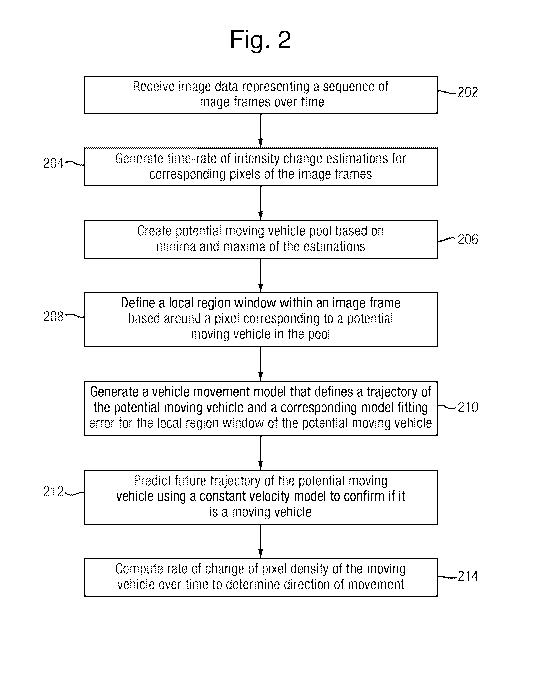
Figure 2 is a flowchart showing steps than can be performed by the
example system, and
Figure 3 shows an example visual output from the example system.
The approach taken by the present inventors to develop and test the
aircraft detection method was to capture camera footage from a number of
encounters with a realistic target aircraft with different crossing angles,
distances, backgrounds, relative heights and, sun positions. This data was
then
used to investigate and mature the method. An
ultimate goal of the
development was to be able to run the detection method with a tracker in
real-time on a representative flight system and integrate with a prototype
Sense
and Avoid system to give adequate collision avoidance performance against a
non-cooperative target.
Figure 1 shows a schematic representation of aircraft 100 including an
image capture device 102 that is communication with a computing device 104.
The aircraft and computing device can be of any conventional type and include
known features (e.g. engines 106 and flight controller 107 for the aircraft,
and
processor 108, storage device 110 and communications interface 112 for the
computing device) that need not be described herein in detail. The image
CA 02880686 2015-01-30
WO 2014/020315 PCT/GB2013/051989
- 10 -
capture device can also be any type of device capable of capturing images,
which can be in digital format, or capable of being transformed into digital
format for processing by the computing device.
In the example embodiment, the aircraft 100 comprised a Jetstream 31
aircraft (G-BVVWW) as a Flying Test Bed (FTB), configured as a surrogate
Unmanned Air Vehicle (UAV), and a Commercial Off-The-Shelf (COTS) Electro
Optic (EO) 'machine vision' camera was used as the image capture device 102.
The camera was matched to a lens to give angular resolution slightly better
than
human 20/20 vision (1 min. of arc). The camera operates with 2456 x 2058 pixel
resolution and is capable of a genuine acquisition rate of 15 Hz. The choice
of a
visible band camera was due to its performance being roughly equivalent to the
human eye, positive size, weight and, power (SWAP) characteristics, low cost,
and, ease of integration.
In one embodiment, a single camera 102 was mounted in the cockpit
central window to give a representative `pilot's eye' view. In other
embodiments
intended to provide a full optical collision avoidance system then an array of
cameras to give the required Field of View (FOV) of +/- 110 deg. from the
aircraft's nose could be provided. This is because the camera can only achieve
the angular resolution requirement over a limited FOV due to its finite pixel
resolution. Therefore, multiple cameras are required to achieve the full FOV
at
the required angular resolution. In multiple camera embodiments, known data
fusion techniques can be used to incorporate image data provided by the
plurality of cameras into the processing method described herein.
CA 02880686 2015-01-30
WO 2014/020315 PCT/GB2013/051989
- 1 1 -
Figure 2 is a flowchart showing example steps that can be performed by
the processor 108, based on code stored in memory 110. It will be understood
that the flowcharts shown is exemplary only and in other embodiments some of
the steps can be omitted and/or re-ordered. The steps can be implemented
using any suitable programming language and data structures. Although the
embodiment shows the computing device 104 onboard the aircraft being used
to detect other aircraft (and could either sound an alarm for a pilot if one
on a
collision course is detected, or control the flight path in an autonomous
craft,
e.g. by controlling flight controller 107) , it will be understood that the
set up can
be varied. For instance, the image capture device 102 and/or the computing
device 104 may not be fitted onboard the vehicle, e.g. at least one of them
could be on a ground station and exchange data/messages with the aircraft. It
will also be understood that embodiments of the method can be produced to
detect moving vehicles other than aircraft, and also versions can be produced
for use with/on other types of vehicles or (static or moving) bodies.
At step 202, the computing device 104 executing the method receives
image data representing a sequence of image frames over time. These will
typically be received substantially in real time over a (wired or wireless)
communications link between the computing device 104 and the image
capturing device 102. The images may be video data, or a sequence of still
images captured over a time period (intervals between the still images which
may or may not correspond to the image capture rate of the device 102). The
image data can be in any suitable format, e.g. MP4, and in some cases may
undergo additional processing steps, such as analogue-to-digital conversion,
CA 02880686 2015-01-30
WO 2014/020315 PCT/GB2013/051989
- 12 -
decryption and/or decompression. To achieve real-time performance in some
embodiments, the inventors chose to process Bayer data directly from the
camera. This meant that computationally costly demosaic interpolation colour
filter conversions could be avoided.
The moving vehicle detection method can make measurements/receive
images at every time step, but may utilise a fixed sliding window approach for
processing them. This defines a set period of time that is shifted at each
time
step and is dependent on the camera frame rate. It provides the upper bound
on the accepted velocity of an aircraft, where different values are suitable
for
aircraft with different velocities. One embodiment of the method used a
temporal window size of 5 steps for this parameter. This meant that by using
the
camera described above, a track could not be designated quicker than 1/3
seconds. By taking into account an algorithm maximum computation time of 1/6
seconds, this compares favourably with human equivalence information
suggesting that a pilot can designate a track in 1 second.
At step 204, the method performs numerical estimation of the first order
temporal derivatives at each time step to generate approximate time-rate of
change of intensity at every point in the image. This is a linear constraint
and on
its own it does not allow calculation of either translational components of
the
image velocity or normal flow magnitude. In one embodiment, the estimates
may be Laplacian first order temporal derivatives, but it will be understood
that
other techniques could be used, e.g. image differencing where two successive
frames are subtracted.
CA 02880686 2015-01-30
WO 2014/020315 PCT/GB2013/051989
- 13 -
The computational complexity of the procedures used in the method will
now be discussed briefly. Herein, computational complexity refers to the
growth
rate of the resources, for example time or memory, required with respect to
the
size of the data processes. The known 0-notation from Computer Science is
used to provide the upper bound of complexity of the algorithms that make up
the approach. Step 202 essentially reduces each image frame from a video
feed to a set of two-dimensional points in image coordinates. These extracted
point features are dependent on spatial and temporal information. The first
order temporal derivatives algorithm involves operations on m matrices each
the size of the image n2. No sub-sampling of the image data is carried out to
reduce the size of n, since the ideal detector must have the ability to detect
an
aircraft as soon as the sensor can resolve it. The overall running time of
this
algorithm is given as 0(mn2) = 0(m-1)0(n2). The quadratic complexity term
means that the instruction count increases by the square of the number of
elements (pixels) in the image; this is only an upper bound for the growth
rate.
Therefore, for large images of the order of megapixels the routine may have
poor scalability; however, at this stage the total number of instructions in
the
algorithm is extremely low. Profiling using current Intel TM hardware shows
the
processing time to be approximately 20 ms for a single frame.
Instead of computing spatial derivatives, the present inventors decided to
dynamically threshold the two-dimensional temporal derivative space. The
method extracts points of maxima and minima rate of intensity change. A single
parameter is required for this, which is dependent on the quality of the
intensity
CA 02880686 2015-01-30
WO 2014/020315 PCT/GB2013/051989
- 14 -
information, and provides an upper bound on the accepted contrast for an
aircraft.
The present inventors speculated that these positions of maxima and
minima correspond to locations in the image coordinate frame that project to
points on possible aircraft in the world, but could also be points on the
ground or
cloud. At step 206, all these maxima and minima detections are stored and
herein are referred to as a "target pool" of potential moving vehicles. The
target
pool also contains position detections from previous time increments
identified
during the sliding time window. At this stage the number of candidate targets
in
the pool is large and with a large number of outliers which need to be
identified.
Regarding the computational complexity of these steps of the method,
the size of the target pool is denoted as p and exists in the interval 0 p n2,
reducing to the number of detected aircraft in the scene. Several algorithms
can be used for the reduction, by discriminating between feature points that
are
potentially aircraft and non-aircraft. The first (step 206, which can comprise
a
feature extraction technique) can comprise a binary search with complexity
0(log p), returning feature points k in the target pool that are spatially
bounded
within the same region of the image. Secondly, a data association algorithm
(step 208) is executed with complexity 0(k2) where k << p. Finally, a model
fitting algorithm (steps 210 and 212) is used to allow both measurement
smoothing and detection predictions, whilst also providing an error measure
used for detection confidence. The runtime complexity is 0(b),where b is the
number of points used to determine the model coefficients, because a single
loop iterates b times to compute a set of summations. A user input parameter
CA 02880686 2015-01-30
WO 2014/020315 PCT/GB2013/051989
- 15 -
can be used to bound the maximum size of the target pool to prevent
illumination changes causing gross detection errors. Again, profiling using
the
same hardware as mentioned above shows the processing time to be
approximately 10 ms for a single frame. There can be other executed
statements in embodiments of the method; however, these are insignificant in
terms of complexity and referred to as c. As a final point, the overall
running
time of the algorithms that make up embodiments of the method can be given
as max(0(mn2),0(k2), 0(b), c), ordered from high to low.
Local regions in the target pool are used to support a best fitted model
using linear least squares estimation, although it will be appreciated that
alternative techniques, e.g. non-linear model or Kalman filter fusion
technique
could be used. The local regions are defined at step 208 using a window that
restricts data association possibilities, whilst keeping detection
chronological
ordering. A local region can be thought of as a number of pixels surrounding a
pixel in the target pool. The latter is important, because whilst optical flow
uses
the sequence of rendered images to allow the estimation of motion, we
similarly
use the sequence of ordered points in the target pool. The size of the window
is
an algorithm parameter, which can be set by a user. It provides an upper bound
on how close multiple detections in the image coordinate frame can be to be
associated to a single aircraft during the time window.
At step 210, a linear model is output that defines a clipped trajectory and
a corresponding model fitting error per local region. This can be done by
means
of a linear least squares fitting technique, which is a form of linear
regression for
calculating the best fit. The clipped trajectory allows estimation of velocity
and
CA 02880686 2015-01-30
WO 2014/020315 PCT/GB2013/051989
- 16 -
direction for a finite period of time bounded by the sliding window. The model
fitting error gives an indication of confidence on the accuracy of the
detection.
For example, if this is high then the relevant points in the target pool do
not
follow a trend and consequently the detections are unlikely to be an aircraft.
For each model, the method at step 212 then predicts forward the
trajectory in the image coordinate frame. Since the prediction is used at the
next
time step, it only needs a myopic predication for a fixed period of time. This
allows the method to use a constant velocity model, which is reasonable, since
during this short time period it is assumed that the aircraft will have a
smooth
and non-erratic motion in the image plane. The prediction is for a constant
finite
small amount of time into the future (e.g. less than 1 second). The prediction
assumes that aircraft moves with constant velocity from its last observed
position and the sensing aircraft stays at a constant orientation. Using the
target position prediction in the image coordinate frame, a 2D Gaussian is
defined to weight any maxima or minima from the two-dimensional derivative
space. This also has the effect of suppressing any noisy responses that may
exist elsewhere. The mean and variance parameters are both algorithm
parameters that we have chosen to be static.
Finally, at step 214, in order to determine whether an aircraft is on a
collision path the method can use a monocular visual depth cue. More
specifically, the method exploits the perceived relative size, so that for
aircraft
that subtends a larger visual angle the closer the aircraft is to the sensor.
This
can depend on the performance of the detection and tracking of the aircraft. A
recursive algorithm maintains a count of the pixel density of each detected
CA 02880686 2015-01-30
WO 2014/020315 PCT/GB2013/051989
- 17 -
aircraft. This produces the size of the aircraft in pixels along the clipped
trajectory, for a bounded period of time, for a set of associated aircraft
positions
in the image plane. The method then takes the derivative of the perceived
relative aircraft size information to determine if the rate of change is
constant,
positive or negative. This is then mapped to an aircraft flying either: (1)
across,
(2) approaching or (3) receding in the image coordinate frame.
Figure 3 shows an example visual output from the aircraft detection
method. A single aircraft (on a non-collision path) 302 of only approximately
4 x
pixels in size traverses the image, moving from regions of sky to cloud. On
10 the left are two sample video frames 304, 306 with the aircraft
delineated in a
circle. To the right are all the thumbnails 308 of the aircraft during its
flight. The
thumbnails make it easy to see which detections are correct or not during the
flight, the variation in appearance in terms of size and shape and colour
against
the sky and cloud. For all test files, the method executed at no less than
30Hz
at full resolution.
For aircraft on a non-collision path, the quantity and quality of
appearance-based information will vary depending on the aircraft flight paths.
This differs to aircraft on a collision path where the appearance information
will
always increase as the range between aircrafts is reducing. In both situations
aircraft will always exhibit significant translational displacement in the
image
coordinate frame, except during a head-on collision where the sensed aircraft
will appear to have negligible or zero translational displacement. This
displacement will also be different to the apparent egomotion of the sensing
aircraft. Embodiments of the aircraft detection method exploits this by using
CA 02880686 2015-01-30
WO 2014/020315 PCT/GB2013/051989
- 18 -
both spatial and temporal information. It is intentional that the algorithm
does
not compensate for the egomotion of the sensing aircraft. This is to eliminate
the need for a localisation solution and consequently to provide a non-GPS
solution. However, to achieve this requires accurate aircraft detections. The
only time that the aircraft pose is needed is to transform all designated
tracks
from the image coordinate frame to a coordinate frame defined as having the
local position of the IMU with the global rotations of the aircraft. Also, the
aircraft detection method does not use a Kalman filter to fuse detection
measurements. This is to allow the output to be used as an input to downstream
tracking systems that may include such statistical estimators, since the
overall
system may not have time-correlated process and measurement errors. In
embodiments of the method, target detection is deterministic and unsupervised,
which is advantageous for meeting UK Civil Aviation Authority approval as the
approach can be formally evaluated. Embodiments are not reliant on known
vehicle appearance information or scene geometry information; instead, they
can use rate of change information in the scene so that any moving object can
be potentially detected as a target vehicle. Not
using scene geometry
information is beneficial as this can be a source of error.