Note: Descriptions are shown in the official language in which they were submitted.
CA 02883396 2015-02-26
WO 2014/092828
PCT/US2013/059957
-1-
GNSS SYSTEM AND METHOD USING UNBIASED CODE PHASE TRACKING WITH
INTERLEAVED PSEUDO-RANDOM CODE
[0001] This application claims priority in U.S. Patent Application No.
13/966,142, filed
August 13, 2013, and U.S. Provisional Patent Application No. 61/702,031, filed
September 17,
2012, both of which are incorporated herein by reference.
BACKGROUND OF THE INVENTION
1. Field of the Invention
[0002] The present invention relates generally to global navigation
satellite system (GNSS)
receiver technology, and in particular to the use of parallel correlation
kernel modules and
tracking signals, such as L2C, for robustness and improving GNSS-based
positioning,
particularly during receiver operation outages, weak signals and other
conditions affecting
receiver performance.
2. GNSS Background Description of the Related Art
[0003] Global navigation satellite systems (GNSSs) include the Global
Positioning System
(GPS), which was established and is operated by the United States government
and employs a
constellation of 24 or more satellites in well-defined orbits at an altitude
of approximately 20,200
km. These satellites continually transmit microwave L-band radio signals in
three frequency
bands, centered at 1575.42 MHz, 1227.60 MHz and 1176.45MHz, denoted as Li, L2
and L5
respectively. All GNSS signals include timing patterns relative to the
satellite's onboard
precision clock (which is kept synchronized by a ground station) as well as a
navigation message
giving the precise orbital positions of the satellites. GPS receivers process
the radio signals,
computing ranges to the GPS satellites, and by triangulating these ranges, the
GPS receiver
determines its position and its internal clock error. Different levels of
accuracies can be achieved
depending on the observables used and the correction techniques employed. For
example,
accuracy within about 2 cm can be achieved using real-time kinematic (RTK)
methods with
single or dual-frequency (Li and L2) receivers.
[0004] GNSS also includes Galileo (Europe), the GLObal NAvigation
Satellite System
(GLONASS, Russia), Beidou (China), Compass (proposed), the Indian Regional
Navigational
Satellite System (IRNSS) and QZSS (Japan, proposed). Galileo will transmit
signals centered at
1575.42 MHz, denoted Li or El, 1176.45 denoted E5a, 1207.14 MHz, denoted E5b,
1191.795
MHz, denoted E5 and 1278.75 MHz, denoted E6. GLONASS transmits groups of FDM
signals
centered approximately at 1602 MHz and 1246 MHz, denoted GL1 and GL2
respectively. QZSS
will transmit signals centered at Li, L2, L5 and E6. Groups of GNSS signals
are herein grouped
into "superbands."
SUBSTITUTE SHEET (RULE 26)
CA 02883396 2015-02-26
WO 2014/092828 PCT/US2013/059957
-2-
[0005] To gain a better understanding of the accuracy levels achievable
by using GNSS, it is
necessary to understand the types of signals available from the GNSS
satellites. One type of
signal includes both the coarse acquisition (C/A) code, which modulates the Li
radio signal, and
the precision (P) code, which modulates both the Li and L2 radio signals.
These are
pseudorandom digital codes that provide a known pattern that can be compared
to the receiver's
version of that pattern. By measuring the time-shift required to align the
pseudorandom digital
codes, the GNSS receiver is able to compute an unambiguous pseudo-range to the
satellite. Both
the C/A and P codes have a relatively long "wavelength," of about 300 meters
(1 microsecond)
and 30 meters (1/10 microsecond), respectively. Consequently, use of the C/A
code and the P
code yield position data only at a relatively coarse level of resolution.
[0006] The second type of signal utilized for position determination is
the carrier signal. The
term "carrier," as used herein, refers to the dominant spectral component
which remains in the
radio signal after the spectral content caused by the modulated pseudorandom
digital codes (C/A
and P) is removed. The Li and L2 carrier signals have wavelengths of about 19
and 24
centimeters, respectively. The GNSS receiver is able to "track" these carrier
signals, and in doing
so, make measurements of the carrier phase to a small fraction of a complete
wavelength,
permitting range measurement to an accuracy of less than a centimeter.
[0007] In stand-alone GNSS systems that determine a receiver's position
coordinates without
reference to a nearby reference receiver, the process of position
determination is subject to errors
from a number of sources. These include errors in the satellite's clock
reference, the location of
the orbiting satellite, ionospheric-induced propagation delay errors, and
tropospheric refraction
errors. A more detailed discussion of these sources of error is provided in
U.S. Pat. No 5,828,336
by Yunck, et al.
[0008] To overcome the errors of stand-alone GNSS, many kinematic
positioning
applications make use of multiple GNSS receivers. A reference receiver located
at a reference
site having known coordinates receives the satellite signals simultaneously
with the receipt of
signals by a remote receiver. Depending on the separation distance, many of
the errors
mentioned above will affect the satellite signals equally for the two
receivers. By taking the
difference between signals received both at the reference site and at the
remote location, these
errors are effectively eliminated. This facilitates an accurate determination
of the remote
receiver's coordinates relative to the reference receiver's coordinates. The
technique of
differencing signals is known in the art as differential GNSS (DGNSS). The
combination of
DGNSS with precise measurements of carrier phase leads to position accuracies
of less than one
CA 02883396 2015-02-26
WO 2014/092828 PCT/US2013/059957
-3-
centimeter root-mean-squared (centimeter-level positioning). When DGNSS
positioning utilizing
carrier phase is done in real-time while the remote receiver is potentially in
motion, it is often
referred to as Real-Time Kinematic (RTK) positioning.
[0009] One method, which effectively gives more measurements in a GPS
system, is to use
dual frequency (DF) receivers for tracking delta-range measurements from P
code modulation on
the Li and L2 carriers simultaneously with the Li C/A code generating code
phase
measurements. The Li and L2 carriers are modulated with codes that leave the
GNSS satellite at
the same time. Since the ionosphere produces different delays for radio
carriers of different
frequencies, such dual frequency receivers can be used to obtain real-time
measurements of
ionospheric delays at various receiver positions. The Li and L2 ranging
measurements are
combined to create a new Li ranging measurement that has an ionospheric delay
of the same
sign as the ionosphere delay in the Li pseudorange. Accurate ionospheric delay
information,
when used in a position solution, can help produce more accuracy. Absent such
real-time
ionospheric delay measurements, other correction techniques are commonly used,
such as
differential GNSS (DGNSS), proprietary third party satellite augmentation
system (SAS)
services available on a paid subscription basis, or the U.S.-sponsored Wide
Area Augmentation
System (WAAS). Similar methods and corresponding equipment configurations can
be used for
other GNSS systems, including those identified above.
[0010] As compared to single-frequency (typically L1) receiver systems,
previous dual-
frequency receiver systems have tended to be relatively expensive because of
their additional
components for accommodating L2 measurements. Moreover, the additional
components tended
to consume more power and required additional space. Still further, dual-
frequency receivers
should be adaptable for use with all present and projected GNSS, transmitting
signals which can
be grouped into two "superbands" of radio signal frequencies generally in the
range of about
1160 MHz to 1250 MHz and 1525 MHz to 1613 MHz. Accordingly, a preferred multi-
frequency receiver should be: a single, application-specific integrated
circuit (ASIC);
programmable for down converting various pairs of frequencies; minimally-
sized; and capable of
operating with minimal power. For example and without limitation on the
generality of
components usable with the present invention, a suitable ASIC is shown and
described in U.S.
Patent No. 8,217,833, which is assigned to a common or jointly-owned assignee
and
incorporated herein by reference.
[0011] The United States' Global Positioning System (GPS) first reached
fully operational
capability on July 17, 1995. After almost two decades, advances in technology
and new demands
CA 02883396 2015-02-26
WO 2014/092828 PCT/US2013/059957
-4-
have prompted efforts to modernize the GPS system. Part of the modernization
are new civilian
navigation signals to be transmitted on a frequency other than the Li
frequency (1575.42 MHz).
This signal became known as the L2C signal because it is a civilian signal
broadcast on the L2
frequency (1227.6 MHz). It is transmitted by all block IIR-M and newer
generation satellites.
[0012] Whitehead et al. U.S. Patent No. 6,744,404 shows an Unbiased Code
Phase Estimator
for Mitigating Multipath in GPS, and is incorporated herein by reference. U.S.
Coast Guard
Navigation Center, "GPS FAQ," U.S. Department of Homeland Security; and
Navstar Global
Positioning System, "Interface Specification-ICD-GPS-200," Navstar GPS Joint
Program Office
are also incorporated herein by reference.
SUMMARY OF THE INVENTION
[0013] This invention relates to the tracking algorithm related to the
new L2C signal. More
specifically, two parallel correlation kernel modules are utilized for
simultaneous processing
based on unknown characteristics, such as positive and negative values of the
navigation data bit
D. Upon resolution of the sign of the navigation data bit D, a corresponding
code phase and
carrier phase discriminator is formed and sent to code and carrier phase
tracking loops to drive
the local replica to follow that of the incoming signals.
[0014] L2C simplifies dual frequency design significantly. Prior to L2C,
there was no
civilian code on the L2 frequency and only a military signal L2P existed on
this frequency. The
structure of L2P is known, however in order to deny unauthorized access to
this military signal,
the L2P is modulated by another unknown signal called Y code. The Y code
complicates the
design of civilian dual frequency receivers significantly. Semi-codeless or
codeless technique
has to be employed to track the L2P(Y) code, which cause performance
degradation, especially
in lower SNR scenarios. In contrast, the structure of the L2C code is
completely known. The
code noise performance of the L2C is expected to be similar to Li C/A. An
advantage of L2C
over Li C/A is that L2C has a pilot tone, which can be tracked with a pure
phase lock loop,
instead of a Costas loop. The former has a 6 dB tracking threshold advantage
compared to a
Costas tracking loop (which is the case of Li C/A carrier). A robust L2
carrier tracking could aid
other tracking loops, such as L2P, L1P and Li C/A. It also brings frequency
diversity to counter
ionosphere scintillation effects, as deep fades are unlikely to occur at the
same time for both Li
and L2. A receiver with L2C tracking will result in less receiver operation
outage and more
robust integrity.
BRIEF DESCRIPTION OF THE DRAWINGS
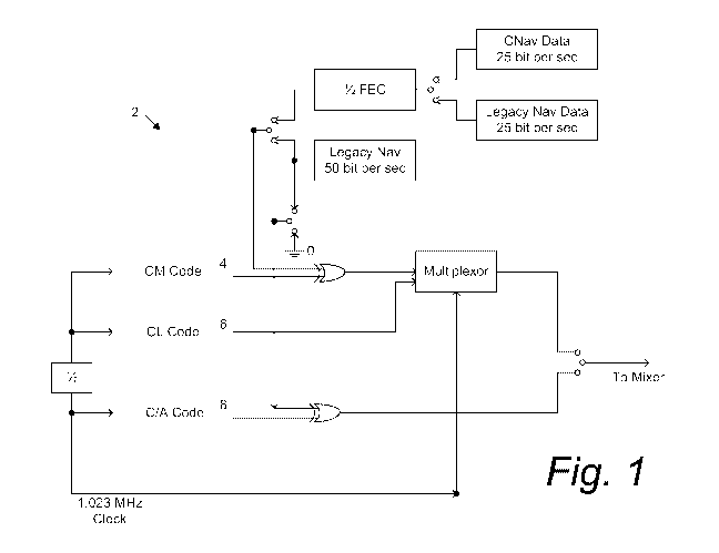
100151 Fig. 1 is a block diagram of a GPS satellite-based circuit for
generating L2C signals.
CA 02883396 2015-02-26
WO 2014/092828 PCT/US2013/059957
-5-
[0016] Fig. 2 is a diagram of the L2C timing relationships.
[0017] Fig. 3a is a diagram of the L2C civilian long (CL) codes.
[0018] Fig. 3b is a diagram of the L2C civilian medium (CDM) codes.
[0019] Fig. 4 is a diagram of the L2C codes showing data dependency.
[0020] Figs. 5a and 5b show a block diagram of a composite code detection
system with
multi-path mitigation embodying an aspect of the present invention.
[0021] Fig. 6a is a diagram of the L2C code when navigation data D = 1.
[0022] Fig. 6b is a diagram of the L2C code when navigation data D = 0 or
(-1).
DETAILED DESCRIPTION OF THE PREFERRED EMBODIMENTS
I. Introduction and Environment
[0023] As required, detailed embodiments of the present invention are
disclosed herein;
however, it is to be understood that the disclosed embodiments are merely
exemplary of the
invention, which may be embodied in various forms. Therefore, specific
structural and
functional details disclosed herein are not to be interpreted as limiting, but
merely as a basis for
the claims and as a representative basis for teaching one skilled in the art
to variously employ the
present invention in virtually any appropriately detailed structure.
[0024] Certain terminology will be used in the following description for
convenience in
reference only and will not be limiting. For example, up, down, front, back,
right and left refer
to the invention as oriented in the view being referred to. The words
"inwardly" and "outwardly"
refer to directions toward and away from, respectively, the geometric center
of the embodiment
being described and designated parts thereof Said terminology will include the
words
specifically mentioned, derivatives thereof and words of similar meaning.
[0025] Global navigation satellite systems (GNSSs) are broadly defined to
include the
Global Positioning System (GPS, U.S.), Galileo (proposed, Europe), GLONASS
(Russia),
Beidou (China), Compass (proposed), the Indian Regional Navigational Satellite
System
(IRNSS), QZSS (Japan, proposed) and other current and future positioning
technology using
signals from satellites, with or without augmentation from terrestrial
sources.
II. Unbiased Code Phase Tracking with Interleaved Pseudo-random (PRN) Code,
such as GPS
L2C
[0026] Fig. 1 illustrates an example of an on board satellite signal-
generating circuit 2 for
generating possible L2C signals. Without limitation on the generality of
useful applications of
the present invention, other signals and signal-generating circuits can also
be used. The signal-
generating circuit 2 includes a civilian moderate length code generator (CM)
4, a civilian long
CA 02883396 2015-02-26
WO 2014/092828 PCT/US2013/059957
-6-
length code generator (CL) 6, and a coarse acquisition code generator (C/A) 8.
There are four
configurable options of the final transmitted L2C signals. For more
information, see Navstar
Global Positioning System, "Interface Specification-ICD-GPS-200," Navstar GPS
Joint Program
Office. The configurable options are:
1) pure C/A code;
2) C/A XOR legacy navigation data;
3) CM XOR CNAV data with CL multiplexing; and
4) CM XOR legacy navigation data with CL multiplexing.
[0027] However, based on observations, pure C/A code and C/A XOR legacy
navigation
data (options 1 and 2 above) are not currently actively configured. Either
option 3 or option 4 is
currently active on the IIR-M satellites and L2C is time-multiplexed between
two distinct PRN
sequences:
1) civilian moderate (CM) length code is 10,230 chips in length, repeating
every 20
milliseconds; and
2) civilian long (CL) length code is 767,250 chips in length, repeating every
1500
milliseconds.
[0028] Both CM and CL codes are clocked at 511,500 chips per second. The
general timing
of the L2C code is shown in Fig. 2. Figs. 3a and 3b show L2C civilian long
(CL) and civilian
medium (CM) codes respectively. The composite L2C code has an equivalent
chipping rate of
1,023,000 chips per second, which is equivalent to Li C/A. CM is modulated
with navigation
data, while CL is dataless.
[0029] The data modulation of CM introduces complexity into the final
composite L2C
signal. Depending on the navigation data D, the L2C could have two possible
waveforms as
illustrated in Fig. 4.
[0030] In a GNSS receiver, the sign of the navigation data D cannot be
predicted. The two
different L2C waveforms are equally likely, depending on navigation data D. In
order to track
the composite L2C signal, it is therefore necessary to have two parallel
correlator kernels, with
one assuming D = 1 (Fig. 6a) while the other D = 0 or (-1). Further, it is
also possible to track the
L2CL and L2CM signals independently, but it results in a 3dB loss of signal
strength. Tracking
L2CL independently and increasing pre-detection integration time can
compensate for this 3dB
loss, but in cases of high dynamics and multi-path it is desirable to track
the composite signal.
[0031] Figs. 5a,b illustrate an aspect of the present invention
comprising part of a system 10
for implementing parallel kernel tracking using composite code detection with
multi-path
CA 02883396 2015-02-26
WO 2014/092828 PCT/US2013/059957
-7-
mitigation. Without limitation, the part of the system 10 shown in Figs.5a, b
can comprise the
components of a GNSS receiver 12 implementing the unbiased code phase tracking
of the
present invention.
[0032] An antenna or antenna array 14 first receives the transmitted RF
pseudo-random
(PRN) encoded signals from one or more GNSS satellite constellation(s), e.g.,
GPS, Glonass,
Galileo, etc. The PRN encoded signals are then down-converted, sampled and
digitized in the
LNA/mixer and analog-to-digital (AID) converter 16 comprising an RF front end
down
convertor. The satellite signals are first received and then down-converted to
an intermediate
frequency (IF), and digitally sampled. The sampled signals are multiplied by a
local replica of
the incoming IF carrier (I ref generator 18 and Q ref generator 20). The
purpose is to remove the
Doppler and move the results to baseband for later accumulation processing.
The digital output
of the I and Q reference generators 18, 20 is connected to accumulator and
dump components 22,
24, 26, 28, 30, 32 via frequency mixers (multipliers) 34.
[0033] At the core of the invention are two parallel correlation kernel
modules 36, 38, one
kernel 36 assuming the navigation data D = 1 and the other kernel 38 assuming
navigation data
D = 0 or (-1). The correlation kernels 36, 38 take the code numerically-
controlled oscillator
(nco) 40 phase of the prompt signal as input, and generate four output signals
that are multiplied
by the Doppler-removed incoming sample signal. The four output signals are:
local prompt chip
44, early-late (E-L) chip 46, pulsed signal at the prompt chip transition edge
48, and pulsed
signal at the prompt chip non-transition edge 50. For more information, see
Whitehead U.S.
Patent No. 6,744,404, which is assigned to a common or commonly-owned assignee
and
incorporated herein by reference.
[0034] One implementation of the pulse signals is illustrated in Figs. 6a
and 6b with both
navigation data D = 1 and D = 0 or (-1), depicting multipath mitigation pulsed
signals with data
dependency. For each correlation kernel 36, 38, there will be the following
accumulate and
dump results:
I_prompt, in phase portion of the correlation results between local prompt
chip and
Doppler-removed incoming signal sample
1
'prompt = [R(T) ¨ Dt, cos a + nicm] x D,+ R(1-)13¨ cos a + ni_cL (1)
2 2
Where:
R(r) is the normalized correlation function of the CM/CL code, and t is the
delay
between the local CM/CL code and that of the incoming. P is the received
carrier power at the
CA 02883396 2015-02-26
WO 2014/092828 PCT/US2013/059957
-8-
receiver front end, the ratio of ¨1 is because the carrier power is equally
split between the CM
2
and CL. Dtx is the navigation data (1 or -1) as transmitted by the satellite,
Dõ is the
navigation data as assumed by one of the two correlation kernels. Dõ takes the
value of 1 or -
1. ni_cm is the noise resulting from the correlation of the local CM code
against the incoming
signal. ni_ci, is the noise resulting from the correlation of the local CL
code against the
incoming signal, a is the phase error between the incoming carrier and the
local replica
carrier.
[0035] Q_prompt, quadrature portion of the correlation results between
local prompt chip
and Doppler-removed incoming signal sample, as below:
Qprompt = [R(T) :17)
¨ D sin a + n(2cm] x D, R(r),\ 11-3¨ sin a +
nQ_CL
2 tx 2
[0036] I_track, in phase portion of the correlation results between local E-
L chip and
Doppler-removed incoming signal sample, spacing between E and L is 1 chip.
[0037] Q_track, quadrature portion of the correlation results between
local E-L chip and
Doppler-removed incoming signal sample, spacing between E and L is 1 chip.
[0038] I_transition, in phase portion of the correlation results between
local pulsed signal at
the prompt chip transition edges and Doppler-removed incoming signal sample.
[0039] I_non-transition, in phase portion of the correlation results
between local pulsed
signal at the prompt chip non-transition edges and Doppler-removed incoming
signal sample.
[0040] The results are sent to a decision metric 52 to validate which
hypothesis is more
likely than the other (D = 1 or D = 0 or (-1)). This can be a prompt power
detector as one of the
two results will give the expected L2C signal power while the other will only
contain noise as
shown below:
Based on Equation (1), assuming that there is no phase error between the
incoming
carrier and the local replica carrier, so a=0
'prompt = [R(T) ¨ Dtx cos a + nicm] x D, R(T) ¨ cos a + nicL
2 2
1
= R(T) ¨ (Dtx X Drx 1) nicm X Drx nicL
2
For one of the correlation kernels, D, = Dtx, while for the other, D, = ¨Dtx,
so the
outputs from the two correlation kernels are:
HO: D, = ¨Dtx
CA 02883396 2015-02-26
WO 2014/092828
PCT/US2013/059957
-9-
=
'prompt R(z) E (D t, x Dõ+ 1) nicm X Dõ+ nicL
\I 2
\173
= WI-) ¨2 (-1 1) nIcm X Dõ n'CL
= nicm X Dõ nicL (2)
Hl: Dõ = Dtx, then
1
5'prompt = R(z) ¨ (D t, x Dr, + 1) + nicm x Dr, + nicL
2
1 = WI-) ¨2 (1 1) nIcm X Dõ n'CL
= R(T)A/3 nIcm X Dõ n'CL (3)
[0041] Based on Equations (2) and (3), the problem becomes the detection
of a deterministic
signal in white Gaussian noise.
[0042] Approaches for solving these types of problems can be found in Kay,
Steven M.,
Fundamentals of Statistical Signal Processing, Detection Theory, Chapter 5,
Sec. 5, which is
incorporated herein by reference.
[0043] With the navigation data bit D resolved, the corresponding code
phase and carrier
phase discriminator can be formed according to U.S. Patent No. 6,744,404 and
sent to the code
and carrier tracking loops to drive the local replica to follow that of the
incoming signals.
[0044] It is to be understood that the invention can be embodied in
various forms, and is not
to be limited to the examples discussed above. Other components and
configurations can be
utilized in the practice of the present invention.