Note: Descriptions are shown in the official language in which they were submitted.
CA 02888252 2015-04-13
WO 2014/178993
PCT/US2014/032943
METHOD OF ENHANCING FLAT SPOTS IN THREE-DIMENSIONAL SEISMIC
INTERPRETATION
CROSS-REFERENCE TO RELATED APPLICATIONS
[0001] Not applicable.
STATEMENT REGARDING FEDERALLY SPONSORED
RESEARCH OR DEVELOPMENT
[0002] Not applicable
BACKGROUND
Field of the Invention
[0003] This invention relates generally to the field of geophysical
exploration for
hydrocarbons. More specifically, the invention relates to a method of flat
spot enhancement in
three-dimensional seismic processing and interpretation.
Background of the Invention
[0004] A seismic survey is a method of imaging the subsurface of the earth by
delivering
acoustic energy down into the subsurface and recording the signals reflected
from the different
rock layers below. The source of the acoustic energy typically comes from a
seismic source
such as without limitation, explosions or seismic vibrators on land, and air
guns in marine
environments. During a seismic survey, the seismic source may be moved across
the surface of
the earth above the geologic structure of interest. Each time a source is
detonated or activated,
it generates a seismic signal that travels downward through the earth, is
reflected, and, upon its
return, is recorded at different locations on the surface by receivers. The
recordings or traces
are then combined to create a profile of the subsurface that can extend for
many miles. In a
two-dimensional (2D) seismic survey, the receivers are generally laid out
along a single straight
line, whereas in a three-dimensional (3D) survey the receivers are distributed
across the surface
in a grid pattern. A 2D seismic line provides a cross sectional picture
(vertical slice) of the
earth layers as arranged directly beneath the recording locations. A 3D survey
produces a data
"cube" or volume that theoretically represents a 3D picture of the subsurface
that lies beneath
the survey area.
[0005] In the oil and gas industry, the primary goal of seismic exploration is
locating
subterranean features of interest within a very large seismic volume. Rock
stratigraphic
1
CA 02888252 2015-04-13
WO 2014/178993
PCT/US2014/032943
information may be derived through the analysis of spatial variations in a
seismic reflector's
character because these variations may be empirically correlated with changes
in reservoir
lithology or fluid content. Since the exact geological basis behind these
variations may not be
well understood, a common method is to calculate a variety of attributes from
the recorded
seismic data and then plot or map them, looking for an attribute that has some
predictive value.
Given the extremely large amount of data collected in a 3-D volume, methods of
enhancing the
appearance of subsurface features related to the migration, accumulation, and
presence of
hydrocarbons are extremely valuable in seismic exploration.
[0006] One particular attribute known as "flat spots" is especially useful to
seismic
interpreters. Seismic flat spots are generally caused by the interface between
two different
types of fluids in a reservoir. This phenomenon is frequently used as a direct
hydrocarbon
indicator in conjunction with seismic amplitudes and AVO techniques in
exploring for
hydrocarbons. Knowledge of the location and extents of suspected hydrocarbon
fluid contacts
can hold great weight in business decisions related to drilling and production
of known
reservoirs, and plays an important role in reconnaissance screening in the
exploration work
process. Fluid contacts in reservoirs are often difficult or impossible to see
on conventional
seismic sections displayed in seismic interpretation systems due to noise,
dipping events, low
amplitude supports, and other subsurface effects. The ability to quickly and
reliably identify
candidates for further examination allows interpreters to apply experience and
knowledge to
classify them as the result of HC fluid contacts or other seismic artifacts.
The state of the art is
the ability to produce flat spot candidates through other methods.
[0007] While most hydrocarbon contacts are physically flat, much like the
surface of a calm
body of water, they may not appear flat in the seismic data, depending on
whether the vertical
unit of the seismic data is time or depth, or, in the case of offshore data,
whether the water
bottom is relatively constant depth or rapidly changing. The common property
that the contacts
share is that they form regions of connected samples with a similar property,
in a roughly
horizontal configuration. A common way of addressing this problem is by
exploiting this
property in some way. The approach is to find events that are approximately
flat, then to figure
out what they are. It should be understood that current methods are limited in
their capability;
all strive to detect a flat event, spots, or areas, but none have the ability
to decisively classify a
flat event as a hydrocarbon contact.
[0008] Consequently, there is a need for methods and systems to enhance flat
spots in the
field of 3D seismic processing and interpretation.
2
CA 02888252 2015-04-13
WO 2014/178993
PCT/US2014/032943
BRIEF SUMMARY
[0009] Embodiments of a method for enhancing flat spots in 3D seismic
interpretation are
disclosed herein. Embodiments of the method generally involve an operation of
horizontally
stacking (summing) traces within a user defined elongate area. The user may
define the size
and shape of the elongate area. Furthermore, the elongate area may be
automatically aligned to
a user defined axis such as without limitation, the structure strike. By
aligning or orienting an
elongate area operator with a selected or user selected axis, and with
appropriate choice of axis
length, it is possible to constrain the stacking operation within geologic
strata, allowing the user
to image even narrow flat events that wrap around a subterranean structure.
The resulting
output from the disclosed methods may also be weighted with covariate
attributes that reflect
other properties embedded within the seismic data. Further details and
advantages of various
embodiments of the method are described in more detail below.
[0010] In an embodiment, a method of enhancing a flat spot for seismic
interpretation
comprises: a) selecting a three-dimensional (3D) seismic input volume
representing a
subterranean region. The 3D seismic input volume comprises a plurality of
seismic traces. The
method also comprises: (b) defining an elongate area along a horizontal plane.
The elongate
area is centered on an individual seismic trace within the seismic input
volume, and the
elongate area encloses a subset of the plurality of seismic traces.
Furthermore, the method
comprises: (c) automatically aligning the elongate area in relation to a user
defined axis. In
addition, the method comprises (d) performing a stack of the subset of traces
defined by the
elongate area and outputting a result to a 3D seismic output volume. The
method also
comprises: (e) repeating (c) and (d) for each sample point down the individual
seismic trace and
outputting each result to the 3D seismic output volume; and (f) positioning
the elongate area on
another individual seismic trace and repeating (c) through (e). At least one
of (a) through (f) is
performed on a computer.
[0011] In another embodiment, a computer system for enhancing flat spots
comprises an
interface for receiving a 3D seismic input volume, the 3D seismic input volume
comprising a
plurality of seismic traces. The computer system further comprises a memory
resource. In
addition, the computer system comprises input and output functions for
presenting and
receiving communication signals to and from a human user. The computer system
also
comprises one or more central processing units for executing program
instructions and program
memory coupled to the central processing unit for storing a computer program
including
program instructions that when executed by the one or more central processing
units, cause the
computer system to perform a plurality of operations for enhancing flat spots
within the seismic
3
CA 02888252 2015-04-13
WO 2014/178993
PCT/US2014/032943
input volume. The plurality of operations comprise: (a) defining an elongate
area along a
horizontal plane, wherein the elongate area is centered on an individual
seismic trace within the
seismic input volume. The elongate area encloses a subset of the plurality of
seismic traces.
The plurality of operations additionally comprise: (b) automatically aligning
the elongate area
in relation to a user defined axis. Moreover, the plurality of operations
comprise: (c)
performing a stack of the subset of traces defined by the elongate area and
outputting a result to
a 3D seismic output volume. The plurality of operations also comprise: (d)
repeating (b) and
(c) for each sample point down the individual seismic trace and outputting
each result to the 3D
seismic output volume. Additionally, the plurality of operations comprise: (e)
positioning the
elongate area on another individual seismic trace and repeating (b) through
(d).
[0012] In another embodiment, a method of enhancing a flat spot in a 3D
seismic input
volume comprises: (a) enclosing a subset of traces within an elliptical area,
wherein the
elliptical area is defined along a horizontal plane and centered on an
individual seismic trace.
The method also comprises: (b) automatically aligning the elliptical area
longitudinally in
relation to structure strike. Additionally, the method comprises: (c)
performing a stack of the
subset of traces defined by the elongate area and outputting the results to a
3D seismic output
volume. The method further comprises: (d) repeating (c) for each time point
down the
individual seismic trace and outputting the results to the 3D seismic output
volume. In
addition, the method comprises: (e) repeating (a) through (d) for a one or
more seismic traces
within the seismic input volume, and wherein at least one of (a) through (d)
is performed on a
computer.
[0013] The foregoing has outlined rather broadly the features and technical
advantages of the
invention in order that the detailed description of the invention that follows
may be better
understood. Additional features and advantages of the invention will be
described hereinafter
that form the subject of the claims of the invention. It should be appreciated
by those skilled in
the art that the conception and the specific embodiments disclosed may be
readily utilized as a
basis for modifying or designing other structures for carrying out the same
purposes of the
invention. It should also be realized by those skilled in the art that such
equivalent
constructions do not depart from the spirit and scope of the invention as set
forth in the
appended claims.
BRIEF DESCRIPTION OF THE DRAWINGS
[0014] For a detailed description of the preferred embodiments of the
invention, reference
will now be made to the accompanying drawings in which:
4
CA 02888252 2015-04-13
WO 2014/178993
PCT/US2014/032943
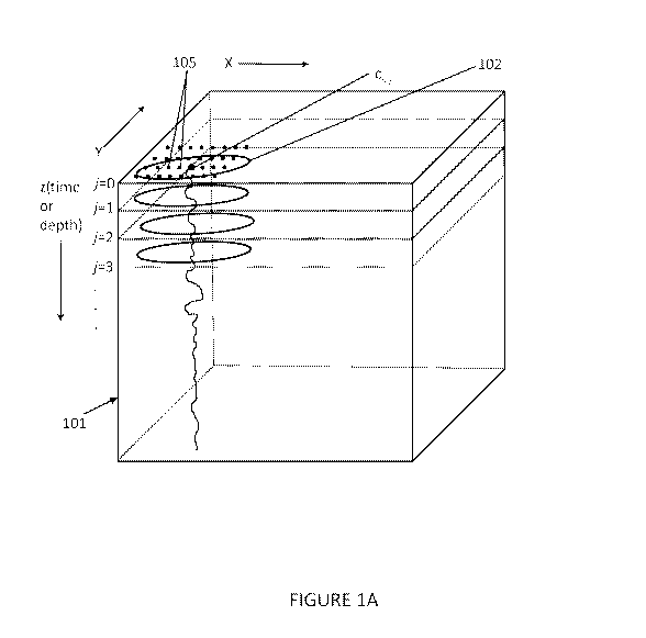
[0015] FIGURE lA illustrates a 3D schematic representation how an embodiment
of the
method for enhancing flat spots is used with a seismic input volume;
[0016] FIGURE 1B illustrates a 3D schematic representation how an embodiment
of the
method for enhancing flat spots is used with a seismic input volume;
[0017] FIGURE 1C illustrates a 2D schematic representation of how an
embodiment of the
method for enhancing flat spots is used with a seismic input volume;
[0018] FIGURE 1D illustrates a 2D schematic representation of how an
embodiment of the
method for enhancing flat spots is capable of guiding or orienting an elongate
area operator to
the local geology;
[0019] FIGURE 2 illustrates a flowchart of an embodiment of a method for
enhancing flat
spots;
[0020] FIGURE 3 illustrates a sample display for optimizing the elongate areas
in an
embodiment of the method;
[0021] FIGURE 4 illustrates another embodiment of the method for enhancing
flat spots.
[0022] FIGURE 5 illustrates a schematic of a system which may be use in
conjunction with
embodiments of the disclosed methods;
[0023] FIGURE 6 illustrates a comparison of a vertical seismic section before
and after flat
spot enhancement with an embodiment of the disclosed method; and
[0024] FIGURE 7 illustrates a horizontal view of a seismic volume after using
an
embodiment of the flat spot enhancement method.
NOTATION AND NOMENCLATURE
[0025] Certain terms are used throughout the following description and claims
to refer to
particular system components. This document does not intend to distinguish
between
components that differ in name but not function.
[0026] In the following discussion and in the claims, the terms "including"
and "comprising"
are used in an open-ended fashion, and thus should be interpreted to mean
"including, but not
limited to. Also,
the term "couple" or "couples" is intended to mean either an indirect or
direct connection. Thus, if a first device couples to a second device, that
connection may be
through a direct connection, or through an indirect connection via other
devices and
connections.
[0027] As used herein, a "dip azimuth" refers to the direction of maximum dip
of a picked
surface or seismic event (i.e., the compass orientation) in the direction of
the dip magnitude.
CA 02888252 2015-04-13
WO 2014/178993
PCT/US2014/032943
[0028] As used herein, "ellipse" or "elliptical" refers to a non-circular and
oval shape having
a major axis, a, and a minor axis, b, where a is greater than b.
[0029] As used herein, "elongate" refers to any non-circular shape which has a
length greater
than its width.
[0030] As used herein, "flat spot" refers to a seismic attribute anomaly that
appears as a
strong horizontal reflector cutting across the other dipping seismic
reflections present on the
seismic image. Flat spots are generally regarded as one of the most definitive
indicators of
hydrocarbons in the subsurface.
[0031] As used herein, "horizontal stack" or "horizontal stacking" refers to
an operation on a
set of traces which sums all the amplitudes at the same time or depth point.
[0032] As used herein, "longitudinal" or "longitudinally" refers to orienting
an elongate
shape or area lengthwise to an axis.
[0033] As used herein, "seismic trace" refers to the recorded data from a
single seismic
recorder or seismograph and typically plotted as a function of time or depth.
DETAILED DESCRIPTION OF THE PREFERRED EMBODIMENTS
[0034] Referring now to the Figures, embodiments of the disclosed methods will
be
described. As a threshold matter, embodiments of the methods may be
implemented in
numerous ways, as will be described in more detail below, including for
example as a system
(including a computer processing system), a method (including a computer
implemented
method), an apparatus, a computer readable medium, a computer program product,
a graphical
user interface, a web portal, or a data structure tangibly fixed in a computer
readable memory.
Several embodiments of the disclosed methods are discussed below. The appended
drawings
illustrate only typical embodiments of the disclosed methods and therefore are
not to be
considered limiting of its scope and breadth.
[0035] Embodiments of the disclosed methods assume a plurality of seismic
traces have been
acquired as a result of a seismic survey using any methods known to those of
skill in the art. A
seismic survey may be conducted over a particular geographic region whether it
be in an
onshore or offshore context. A survey may be a three dimensional (3D) or a two
dimensional
(2D) survey. The raw data collected from a seismic survey are unstacked (i.e.,
unsummed)
seismic traces which contain digital information representative of the volume
of the earth lying
beneath the survey. Methods by which such data are obtained and processed into
a form
suitable for use by seismic processors and interpreters are well known to
those skilled in the art.
Additionally, those skilled in the art will recognize that the processing
steps that seismic data
6
CA 02888252 2015-04-13
WO 2014/178993
PCT/US2014/032943
would normally go through before it is interpreted: the choice and order of
the processing steps,
and the particular algorithms involved, may vary markedly depending on the
particular seismic
processor, the signal source (dynamite, vibrator, etc.), the survey location
(land, sea, etc.) of the
data, and the company that processes the data.
[0036] The goal of a seismic survey is to acquire a set of seismic traces over
a subsurface
target of some potential economic importance. Data that are suitable for
analysis by the
methods disclosed herein might consist of, for purposes of illustration only,
a 2-D stacked
seismic line extracted from a 3-D seismic survey or, a 3-D portion of a 3-D
seismic survey.
However, it is contemplated that any 3-D volume of seismic data might
potentially be
processed to advantage by the methods disclosed herein. Although the
discussion that follows
will be described in terms of traces contained within a stacked and migrated 3-
D survey, any
assembled group of spatially related seismic traces could conceivably be used.
After the
seismic data are acquired, they are typically brought back to the processing
center where some
initial or preparatory processing steps are applied to them.
[0037] The methods disclosed herein may be applied at the data enhancement
stage, the
general object of the disclosed methods being to use the seismic input volume
101 to produce a
"seismic output cube" which can then be utilized by the interpreter in his or
her quest for
subterranean exploration formations, specifically flat spot identification. It
might also contain
other attributes that are correlated with seismic hydrocarbon indicators.
Figures 1A-C and 2
illustrate visually an embodiment of a method and includes a flow chart that
illustrates an
embodiment of the disclosed method, wherein a flat spot is enhanced.
[0038] Referring now to Figures 1A-C and 2, in an embodiment, the method of
enhancing a
flat spot generally involves an operation of horizontally stacking (summing)
traces within a
user defined area 102. As will be discussed in more detail below, the area 102
is centered on a
single trace, ci,/, in a 3D seismic input volume 101 where subscript i
represents the trace number
and subscript/ represents the sample number in that particular trace. For
example, 0, m refers
to sample number 10 in designated seismic trace number 3 in seismic volume
101. As shown
and known in the art, seismic input volume 101 has three axes: an x axis and a
y axis
representing the horizontal plane, and the z axis representing time or depth.
More particularly,
referring to Figures lA - 1B and Figure 2, a seismic input cube or volume 101
representing a
region of interest is selected through geological analysis, or other methods
known to those of
skill in the art in 201 of Figure 2. The seismic input volume 101 may also be
a subset or sub-
volume of a larger seismic input volume of which a user desires flat spot
enhancement in
accordance with the embodiments disclosed herein. Nevertheless, as described
above, the 3D
7
CA 02888252 2015-04-13
WO 2014/178993
PCT/US2014/032943
seismic input volume contains many seismic traces 105 (as represented by the
individual dots)
acquired from a 3D seismic survey. For the sake of clarity, only a sampling of
the seismic
traces 105 are shown for illustrative purposes in the volumetric
representations in Figures lA
and 1B.
[0039] Referring now to Figure 2, in 203, the dimensions of an elongate area
or operator are
selected. In an embodiment, the user defined area 102 may be an elliptical
area or ellipse.
However, it is contemplated the area or operator may be any suitable elongate
shape which is
capable of being aligned with the alignment axis such as without limitation, a
rectangle, a
polygon, or even a curvilinear shape. The user may also select an orientation
direction or axis
for the elongate area 102 to be aligned in 203. The elongate area 102 may then
be aligned with
a user defined axis or alignment axis in 205. As used herein, "user defined
axis" and
"alignment axis" may be used interchangeably to mean an orientation direction
or axis selected
by a user to which the elongate area operator 102 is aligned. Supported
orientation directions
or defined axes for the alignment of the elongate area 102 include without
limitation, dip
azimuth (read from a dip azimuth volume, a dip component volume, apparent dip
volumes, a
picked structural azimuth surface, or derived from a picked structure
surface), fixed inline,
fixed crossline, or arbitrary user track (traverse) through the 3D volume. As
mentioned above,
elongate area 102 is centered on a sample number j, of seismic trace, c1,1, in
a 3D seismic input
volume 101.
[0040] In an embodiment where the elongate area is an elliptical area, the
designated
"steering axis" may be automatically aligned to the dip azimuth. Either axis,
a or b, of the
ellipse may be designated as the "steering axis." However, the steering axis
may be aligned
with any chosen orientation direction or alignment axis. More particularly,
the steering axis
may be oriented with any of the user defined axes described herein (e.g. dip
azimuth, inline,
crossline, etc.).
[0041] In an embodiment, elongate area 102 may be defined and oriented to the
dip azimuth
according to the following equation:
(x2+(y2-x2)sin 92_2xy sin& cos (y2+(x2-3,2) sin 92_2xy sin9 cos
___________________________________________________ = 1 (1)
a2 ___________________________________ b2
Where x and y are coordinates in a Cartesian coordinate system, a is the
length of the major
axis, b is the length of the minor axis, and 0 is the angle at which the
ellipse should be adjusted
based on the user defined axis or direction. By way of example only, if dip
azimuth is the
8
CA 02888252 2015-04-13
WO 2014/178993 PCT/US2014/032943
chosen alignment axis or direction, then the dip azimuth for seismic trace,
ci,j, would be used as
the value of 0. More particularly, seismic traces may be tested for inclusion
in the aligned
elliptical area by substituting the distance or displacement from the x-y
coordinates of the test
seismic trace from the seismic trace, ci, j, into equation (2) which has been
rotated to a set of
axes aligned with the selected orientation direction, 0, of user defined axis.
(x2
+00,2 2 \
OX ) sin 02-2axay sin9 cos (1xy2 (1xx2_ 2 \
) sin 02-2axay sin9 cos
_____________________________________________________ < 1 (2)
a2 b2
where Ax = (x-x) and Ay = (y-ye) represent the distance or displacement of the
x-y coordinates
of the test seismic trace from the seismic trace, ci,j, and xe, ye are the
coordinates of center
seismic trace, c1,1. When the displacements or distances of the x-y
coordinates of the test seismic
trace from the seismic trace G./ are substituted into equation (2) and the
resultant value is less
than or equal to 1 then the test seismic trace is included in the stacking
operation in 207. If the
resultant value is greater than 1 then that seismic trace is excluded.
[0042] By aligning the elongate area 102 with an alignment axis selected by
the user, and
with appropriate choice of major and minor axis length, it is possible to
constrain the stacking
operation within geologic strata, allowing the user to image even narrow flat
events that wrap
around a subterranean structure. Figure 1D illustrates schematically the
theoretical placement
of an exemplary sampling of the areas 102 as they are aligned during the
process 200. To avoid
confusion, Figures 1C and 1D show a view looking down from above the seismic
input volume
101 rather than a vertical section of volume 101.
[0043] In embodiments where the user defined area 102 is an ellipse, the user
may specify
the lengths of the major and minor axes, a and b, respectively of the ellipse.
By doing so, the
user can define or choose how many traces 105 to include in defined elongate
area operator
102. That is, user can define the area of the operator 102. In addition, a
user may define how
long and/or narrow the elongate area 102 may be depending on the subterranean
landscape and
formations. By way of example only, referring to Figure 1C, elliptical area
102A is too wide in
the subterranean structure, and therefore including the traces reflecting
strata P and Q.
However, elliptical area 102B is appropriately sized and does not overlap
strata P and Q. Thus,
one advantage of the disclosed methods is optimizing the elongate area 102 to
avoid inclusion
of data from inhomogeneous geologic structures and thereby enhancing the
presence of any flat
spots.
9
CA 02888252 2015-04-13
WO 2014/178993
PCT/US2014/032943
[0044] In a further embodiment, referring to Figure 3, a preview of the size
and orientation of
a sampling of areas 102 may be displayed prior to the computer intensive
stacking operations.
Window 301 is a display of the time (depth) structure map and window 302 is a
display of the
areas 102 in a dip azimuth map. The side by side display enables a user to
ensure the areas 102
are the optimal size.
[0045] In yet another embodiment, the elongate area 102 may be automatically
adjusted for
each trace 105. That is, depending on the subterranean formation as determined
by the subset
of traces contained within area 102, the elongate area 102 may be
automatically optimized by
size and/or shape.
[0046] In 209, the subset of traces defined by the elongate area 102 is then
stacked (i.e.
summed). The subset of traces defined by the elongate area 102, depending on
the user or the
subterranean terrain, may include traces that land on the border or edge of
elongate area 102.
This may be adjusted by modifying equation (2) such that only test seismic
traces which are
less than 1 are included in the stacking operation. As such, this disclosure
contemplates
embodiments where traces on the border of elongate area 102 may be included or
excluded for
the stacking operation. The result of the stacking operation is then written
to a corresponding
3D output seismic volume.
[0047] In the stacking operation 207 and 211, traces which are contained or
defined by the
operator 102 may be weighted, from the seismic trace at the center, c1,j, of
the area 102
outward, with weights chosen from several bi-variate (x-y) distributions
including without
limitation, uniform, Gaussian, exponential, and triangular. In operation 211,
the stacking
operation iteratively proceeds down the center seismic trace, ci, in the z
direction
(corresponding to time or depth) for each sample, j. The seismic traces may be
acquired at any
sampling rate known to those of skill in the art. By way of example only, each
seismic trace
may have a data point every 4 ms for 6 s, making a total of 1,501 data points
per trace. As the
stacking operation iterates down the seismic trace for each sample j=0, 1, 2,
3... in the z
direction (e.g. time or depth) the structure and thus the dip azimuth may
change. As such, the
corresponding orientation of the elongate area 102 may also change or be
adjusted in response
to any associated structural change. The calculation at sample number./ for
seismic trace, ci,
the ellipse center is the weighted sum of the amplitudes at the corresponding
sample j of all of
the traces inside the elongate operator (e.g. a horizontal stack). In
operation 211, as shown in
Figure 1B the area 102 may then be iteratively progressed so that it is
centered on the next
adjacent seismic trace (labeled c1+/,1 in Figure 1B) and the subset of traces
within the area 102
for each sample j in seismic trace, ci-kij, are then horizontally stacked. The
dashed elongate
CA 02888252 2015-04-13
WO 2014/178993
PCT/US2014/032943
area represents the previous location of the elongate area 102. In an
embodiment, operations
205 through 211 may then be repeated or iterated until every trace 105 and
each sample in each
trace in the seismic input cube have gone through the process in 205 through
211.
Alternatively, operations 205 through 211 may be repeated or iterated or a
user defined subset
of traces 105 within seismic volume 101.
[0048] The flat spot enhancement attribute produced by the bi-variate weighted
horizontal
stacking operation described above for 207 and 211 may also be referred to as
a "simple stack."
The simple stack is effective in dipping strata; obvious flat spots show up at
the extremes of the
color table when viewed in the seismic interpretation system. However, the
attribute properties
are those of the sample mean, and there may be some side effects.
[0049] For example, the attribute value at a given point can be affected by a
few extreme
values (e.g. sample amplitudes of high magnitudes, often outliers). A large
sum can be
generated, and may be spread over a large areal extent, depending on the
weighting scheme and
operator size. This may appear to be a flat spot, when it actually is not (a
"false positive"). Or,
an otherwise significant sum can be nullified by the addition of a single
sample with negative
amplitude, causing a flat spot to be missed.
[0050] In view of the above side effects, in a further embodiment, a
horizontal coherence
attribute may be calculated from the samples within the elongate area operator
102 and this
coherance attribute may be applied as an additional weight to the simple stack
value. The
coherence attribute, an indication of (horizontal) waveform similarity, will
show high
coherence when all samples are similar polarity (as would be expected when the
reflecting
surface is a fluid contact). It significantly attenuates higher magnitude
stack values that are
caused by outliers. In addition, being self-normalizing, it boosts flat spots
calculated in areas of
low seismic amplitude, moving them to the tails of the distribution where they
are more likely
to be visible.
[0051] In another embodiment, the local structural dip may be employed to
avoid false
positives. Local structural dip can be estimated from the seismic amplitude
data, or the
structural dip for a sample can be taken from either the dip cube or the
structure surface; it can
be applied as a weight by measuring its deviation from the horizontal X-Y
plane. A deviation
of zero suggests an anticline or flat structure, so the stack value would be
zeroed out. However,
a non-zero deviation suggests that the stack value has been calculated in a
local environment
with dip, and thus the stack value is given a weight of 1 (it is allowed to
retain its original
calculated value). This has the effect of eliminating distracting flat events
that are caused
solely by the geology.
11
CA 02888252 2015-04-13
WO 2014/178993
PCT/US2014/032943
[0052] In an embodiment, referring now to Figure 4, an additional feature
(which may be
used in combination with the local structural dip weighting) for further
enhancement is
available when either a target area and/or a target horizon slice,
representing a sub-volume 401
of seismic volume 101 is selected for the guided flat spot enhancement. Thus,
in an
embodiment, the (fully weighted) methods may be constrained to specific sample
numbers, j,
above and below a selected horizon or surface (i.e. time or depth slice),
providing a thin volume
401A for flat spot enhancement. This feature allows the user to focus on
specific target areas,
usually on the flanks of structures, and deeper in the subsurface, which
avoids the flatter near-
surface geology. In addition, a smaller target area on the surface may be
selected resulting in a
narrow seismic volume 401B. For example, only seismic traces c1 through cm()
may be selected
for flat spot enhancement. Alternatively, both a focused target area and
time/depth slice may
be selected resulting in a sub-volume 401C be enhanced.
[0053] The net result of the selection or target areas and/or horizon slices
is the enhancement
of flat events in a targeted volume, and which does not contain
distracting/irrelevant events.
The seismic data outside the target analysis window may be zeroed out, or
given a small weight
(but is otherwise not processed) so that the output cube contains both
enhanced data in the
select area of interest and unprocessed data for visual context.
[0054] Those skilled in the art will appreciate that the disclosed methods may
be practiced
using any one or combination of hardware and software configurations,
including but not
limited to a system having single and/or multi-processer computer processors
system, hand-
held devices, programmable consumer electronics, mini-computers, mainframe
computers,
supercomputers, and the like. The disclosed methods may also be practiced in
distributed
computing environments where tasks are performed by servers or other
processing devices that
are linked through one or more data communications networks. In a distributed
computing
environment, program modules may be located in both local and remote computer
storage
media including memory storage devices.
[0055] Figure 5 illustrates, according to an example of an embodiment computer
system 20,
which may perform the operations described in this specification to perform
the operations
disclosed in this specification. In this example, system 20 is as realized by
way of a computer
system including workstation 21 connected to server 30 by way of a network. Of
course, the
particular architecture and construction of a computer system useful in
connection with this
invention can vary widely. For example, system 20 may be realized by a single
physical
computer, such as a conventional workstation or personal computer, or
alternatively by a
computer system implemented in a distributed manner over multiple physical
computers.
12
CA 02888252 2015-04-13
WO 2014/178993
PCT/US2014/032943
Accordingly, the generalized architecture illustrated in Figure 5 is provided
merely by way of
example.
[0056] As shown in Figure 5 and as mentioned above, system 20 may include
workstation 21
and server 30. Workstation 21 includes central processing unit 25, coupled to
system bus.
Also coupled to system bus BUS is input/output interface 22, which refers to
those interface
resources by way of which peripheral functions P (e.g., keyboard, mouse,
display, etc.)
interface with the other constituents of workstation 21. Central processing
unit 25 refers to the
data processing capability of workstation 21, and as such may be implemented
by one or more
CPU cores, co-processing circuitry, and the like. The particular construction
and capability of
central processing unit 25 is selected according to the application needs of
workstation 21, such
needs including, at a minimum, the carrying out of the functions described in
this specification,
and also including such other functions as may be executed by computer system.
In the
architecture of allocation system 20 according to this example, system memory
24 is coupled to
system bus BUS, and provides memory resources of the desired type useful as
data memory for
storing input data and the results of processing executed by central
processing unit 25, as well
as program memory for storing the computer instructions to be executed by
central processing
unit 25 in carrying out those functions. Of course, this memory arrangement is
only an
example, it being understood that system memory 24 may implement such data
memory and
program memory in separate physical memory resources, or distributed in whole
or in part
outside of workstation 21. In addition, as shown in Figure 5, seismic data
inputs 28 that are
acquired from a seismic survey are input via input/output function 22, and
stored in a memory
resource accessible to workstation 21, either locally or via network interface
26.
[0057] Network interface 26 of workstation 21 is a conventional interface or
adapter by way
of which workstation 21 accesses network resources on a network. As shown in
Figure 5, the
network resources to which workstation 21 has access via network interface 26
includes server
30, which resides on a local area network, or a wide-area network such as an
intranet, a virtual
private network, or over the Internet, and which is accessible to workstation
21 by way of one
of those network arrangements and by corresponding wired or wireless (or both)
communication facilities. In this embodiment of the invention, server 30 is a
computer system,
of a conventional architecture similar, in a general sense, to that of
workstation 21, and as such
includes one or more central processing units, system buses, and memory
resources, network
interface functions, and the like. According to this embodiment of the
invention, server 30 is
coupled to program memory 34, which is a computer-readable medium that stores
executable
computer program instructions, according to which the operations described in
this
13
CA 02888252 2015-04-13
WO 2014/178993
PCT/US2014/032943
specification are carried out by allocation system 30. In this embodiment of
the invention,
these computer program instructions are executed by server 30, for example in
the form of a
"web-based" application, upon input data communicated from workstation 21, to
create output
data and results that are communicated to workstation 21 for display or output
by peripherals P
in a form useful to the human user of workstation 21. In addition, library 32
is also available to
server 30 (and perhaps workstation 21 over the local area or wide area
network), and stores
such archival or reference information as may be useful in allocation system
20. Library 32
may reside on another local area network, or alternatively be accessible via
the Internet or some
other wide area network. It is contemplated that library 32 may also be
accessible to other
associated computers in the overall network.
[0058] The particular memory resource or location at which the measurements,
library 32,
and program memory 34 physically reside can be implemented in various
locations accessible
to allocation system 20. For example, these data and program instructions may
be stored in
local memory resources within workstation 21, within server 30, or in network-
accessible
memory resources to these functions. In addition, each of these data and
program memory
resources can itself be distributed among multiple locations. It is
contemplated that those
skilled in the art will be readily able to implement the storage and retrieval
of the applicable
measurements, models, and other information useful in connection with this
embodiment of the
invention, in a suitable manner for each particular application.
[0059] According to this embodiment, by way of example, system memory 24 and
program
memory 34 store computer instructions executable by central processing unit 25
and server 30,
respectively, to carry out the disclosed operations described in this
specification, for example,
by way of which the elongate area may be aligned and also the stacking of the
traces within the
elongate area. These computer instructions may be in the form of one or more
executable
programs, or in the form of source code or higher-level code from which one or
more
executable programs are derived, assembled, interpreted or compiled. Any one
of a number of
computer languages or protocols may be used, depending on the manner in which
the desired
operations are to be carried out. For example, these computer instructions may
be written in a
conventional high level language, either as a conventional linear computer
program or arranged
for execution in an object-oriented manner. These instructions may also be
embedded within a
higher-level application. Such computer-executable instructions may include
programs,
routines, objects, components, data structures, and computer software
technologies that can be
used to perform particular tasks and process abstract data types. It will be
appreciated that the
scope and underlying principles of the disclosed methods are not limited to
any particular
14
CA 02888252 2015-04-13
WO 2014/178993
PCT/US2014/032943
computer software technology. For example, an executable web-based application
can reside at
program memory 34, accessible to server 30 and client computer systems such as
workstation
21, receive inputs from the client system in the form of a spreadsheet,
execute algorithms
modules at a web server, and provide output to the client system in some
convenient display or
printed form. It is contemplated that those skilled in the art having
reference to this description
will be readily able to realize, without undue experimentation, this
embodiment of the invention
in a suitable manner for the desired installations. Alternatively, these
computer-executable
software instructions may be resident elsewhere on the local area network or
wide area
network, or downloadable from higher-level servers or locations, by way of
encoded
information on an electromagnetic carrier signal via some network interface or
input/output
device. The computer-executable software instructions may have originally been
stored on a
removable or other non-volatile computer-readable storage medium (e.g., a DVD
disk, flash
memory, or the like), or downloadable as encoded information on an
electromagnetic carrier
signal, in the form of a software package from which the computer-executable
software
instructions were installed by allocation system 20 in the conventional manner
for software
installation.
EXAMPLE
[0060] Referring now to Figure 6, an embodiment of the method for enhancing
flat spots was
applied to a sample seismic input volume. The seismic vertical section on the
left is shown
prior to enhancement with the disclosed method. The red oval encircles the
flat spot which can
barely be seen as surrounded by the other numerous dipping events. The seismic
vertical
section on the right is shown after enhancement by the disclosed method. The
flat spot is
clearly shown and is much more easily identified in the encircled area.
[0061] Figure 7 shows the results of an interpretation after using an
embodiment of the flat
spot enhancement method. Because every seismic trace within a seismic input
volume is
subject to the method, a very detailed view of the top of the flat spot may be
created as a result
of the method.
[0062] While the embodiments of the invention have been shown and described,
modifications thereof can be made by one skilled in the art without departing
from the spirit
and teachings of the invention. The embodiments described and the examples
provided herein
are exemplary only, and are not intended to be limiting. Many variations and
modifications of
the invention disclosed herein are possible and are within the scope of the
invention.
Accordingly, the scope of protection is not limited by the description set out
above, but is only
CA 02888252 2015-04-13
WO 2014/178993
PCT/US2014/032943
limited by the claims which follow, that scope including all equivalents of
the subject matter of
the claims.
[0063] The discussion of a reference is not an admission that it is prior art
to the present
invention, especially any reference that may have a publication date after the
priority date of
this application. The disclosures of all patents, patent applications, and
publications cited
herein are hereby incorporated herein by reference in their entirety, to the
extent that they
provide exemplary, procedural, or other details supplementary to those set
forth herein.
16