Note: Descriptions are shown in the official language in which they were submitted.
CA 02893361 2015-06-02
1
Determination of initial tool orientation
FIELD OF THE INVENTION
The invention relates to the determination of initial tool orientation, for
example
determining the initial orientation of an instrument package to be moved along
a
wellbore.
BACKGROUND OF THE INVENTION
As of today onsite calibration and initialization of tools, using
accelerometers, magnetic
and gyroscopic sensors, are mainly done using sensors in the tool, and to some
extent
physical models. For some tools "foresighting" techniques are used when
movement of
the drilling vessel (for example an onshore or offshore drilling platform, a
floating or
fixed platform or a boat) does not allow for tool initialization using the
tool sensors. The
method aligns the tool to a reference point ("foresight") on the drilling
site, to determine
an approximate azimuth direction for initialization purposes. As the reference
point
position is not dynamically updated, the method has drawbacks when used on a
moving drilling vessel, such as a floating drilling unit in high seas.
The following two patents relate to apparatuses for initializing wellbore
survey tools:
US 8,305,230, in the name of Gyrodata Incorporated, an apparatus for
initialization of
gyro tools using satellite navigation syst ms. The apparatus includes the use
of a
mechanically coupled mounting portion to dive the tool a predetermined
orientation to a
directional reference system.
US 2013/0127631, in the name of Gyrodata Incorporated, describes an apparatus
for
transferring orientation from a directional reference frame to a tool. The
apparatus
uses mechanical couplings to a directional reference system and to the tool to
transfer
orientations.
Existing technology is known which uses measurements of the earth's magnetic
field or
measurements of the earth's rotation rate to estimate initial tool
orientation. The earth's
2
magnetic field is measured by means of magnetometers or magnetic compassing.
The
earth's rotation rate is measured by gyroscopes. Both methods utilizing the
earth's
magnetic field and the earth's rotation rate become gradually more inaccurate
as
latitude increases, making them unreliable for use in arctic regions.
Using measurements of the earth's rotation rate to find the initial tool
orientation is
troublesome and inaccurate when performed on a vessel with large and frequent
movements, such as an offshore drilling unit in high seas.
The patented Gyrodata technology, not yet fully developed, comprises
mechanical
coupling of the tool to a directional reference frame, or a device
transferring orientation
from a directional reference frame to the tool, making it cumbersome to handle
the tool
or/and the transferring device.
SUMMARY OF THE INVENTION
The invention provides a method of determining the initial orientation of a
tool.
According to an aspect of the present invention there is provided a method of
determining the
initial orientation of a tool to be moved from a drilling site along a
wellbore in the earth, the
method comprising:
defining a drilling site coordinate system which is fixed relative to said
drilling site;
defining a tool coordinate system which is fixed relative to said tool;
providing at least one marker on said drilling site, defining at least one
drilling site
reference point which is fixed relative to said drilling site coordinate
system;
providing at least one marker on said tool, defining at least one tool
reference point
which is fixed relative to said tool coordinate system;
determining the positions of said drilling site and tool reference points; and
using said determined positions to perform a coordinate transformation between
said
drilling site and tool coordinate systems in order to determine the
orientation of said tool.
In some embodiments, the method further comprises:
defining an earth coordinate system which is fixed relative to the earth;
determining the positions, at a specific instant in time, of at least three
drilling site
reference points relative to said earth coordinate system; and
using the determined positions of said at least three drilling site reference
points to
perform a coordinate transformation to transform positions defined in said
site coordinate
system to positions defined in said earth coordinate system.
CA 2893361 2019-04-17
2a
In some embodiments, the method further comprises:
determining the positions of said at least one tool reference point relative
to said site
coordinate system; and
using the determined positions of said at least one tool reference point to
perform a
coordinate transformation to transform positions defined in said tool
coordinate system to
positions defined in said site coordinate system.
In some embodiments, said markers include at least one optical marker.
In some embodiments, said at least one optical marker is provided with a
printed pattern.
In some embodiments, said markers include at least one acoustic marker
arranged to send or
receive an acoustic signal.
In some embodiments, said markers include at least one electromagnetic marker
arranged to
send or receive an electromagnetic signal.
In some embodiments, said tool is provided with at least one attachment which
is fixed relative
to said tool coordinate system, and wherein at least one of said markers is
provided on said
attachment.
In some embodiments, said attachment is an elongate member which defines a
specified
direction in said tool coordinate system.
In some embodiments, the method which comprises using an optical measuring
device to
determine the position of at least one of said markers.
In some embodiments, said optical measuring device is a theodolite or 3D laser
scanner.
In some embodiments, the or each drilling site reference point has a
corresponding signal
receiver for receiving signals from a positioning system, and wherein said
position of the or each
drilling site reference point is determined by calculating the positions of
said signal receivers.
In some embodiments, the orientation of said tool is determined relative to
said earth coordinate
system.
CA 2893361 2019-04-17
2b
In some embodiments, the orientation of said tool is determined at a fixed
instant in time.
In some embodiments, the orientation of said tool is determined as a
function.of time.
BRIEF DESCRIPTION OF THE FIGURES
Figure 1 shows the relationship between three different coordinate systems;
Figure 2 shows the transformation of a point P between three coordinate
systems using
scale, translation and rotation;
Figure 3 shows components of a system for performing translations;
Figure 4 shows a system for performing translations using markers and
reflectors; and
Figure 5 shows a further system for performing translations using markers and
reflectors.
DESCRIPTION OF PREFERRED EMBODIMENTS
CA 2893361 2019-04-17
CA 02893361 2015-06-02
3
Each feature disclosed or illustrated in the present specification may be
incorporated in
the invention, whether alone or in any appropriate combination with any other
feature
disclosed or illustrated herein.
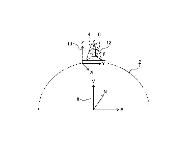
Figure 1 is a schematic diagram showing the surface of the earth 2, and a
drilling rig 4,
which may be a floating rig, located on the surface of the earth 2. The
drilling rig 4 may
move relative to the earth 2. A wellbore survey tool 6 is positioned on the
rig 4 and
moves with the rig 4. We define three 3D coordinate systems, namely:
a) an earth coordinate system 8, which is fixed relative to the earth 2;
b) a rig or drilling site coordinate system 10, which is fixed relative to the
rig 4 and
which moves with the rig 4; and
c) a tool coordinate system 12
Figure 2 shows how a point P may be transformed between the three coordinate
systems 8, 10 and 12.
We describe methods of determining initial tool orientation, which may include
dynamically updated reference points. The reference points are known, fixed
positions
in a given coordinate system.
We describe a method for determining the orientation of a tool relative to a
fixed
reference frame, determined by a local or global fixed coordinate system, such
as
WGS 84 (a 3D coordinate reference system often used with GPS systems), UTM (a
2D
coordinate system often used for map planes) or a locally defined coordinate
system
(field specific), instantly or as a function of time.
The term "tool" may herein include any instrument package to be moved along a
wellbore trajectory, for instance as a part of a wireline unit or bottomhole
assembly.
The method involves the transformation between coordinate systems moving
relative to
the fixed reference frame using dynamically updated reference points on the
drilling
unit.
CA 02893361 2015-06-02
4
Using satellite receivers, radio navigation systems or positioning data from
the vessel's
DPS (dynamic positioning system), the current positions of the signal
receivers or
antennas can be found relative to the fixed reference system.
Using three or more reference points, a site specific coordinate system for
the moving
site, for example a drilling site, can be defined. Using surveying techniques,
such as
photogrammetric or traditional geodetic techniques involving theodolites and
electronic
distance measuring devices, the position of the antennas/receivers can be
determined
in the site specific coordinate system utilizing direction and distance
measurements.
A first three dimensional coordinate transformation consisting of scaling,
translation
and rotation elements, can then be defined using the time synchronized dual
positions
of the antennas/receivers in both the locally defined and fixed coordinate
system, which
can be used to transform positions defined in the local coordinate system to
current
-- positions in the fixed coordinate system.
Figure 3 shows components of a system used to perform translations. A survey
tool 6
carries a frame 14, which in turn carries markers 20.
Two types of markers are used. Markers 20 are able to receive and reflect
incoming
signals, and are also able to transmit signals. The transmitted signals may be
optical,
acoustic or electromagnetic. Markers 22 are able to receive and reflect
incoming
signals, but do not transmit signals. Also shown in Figure 3 is a main
measuring
device 24.
Figure 4 shows a system in which markers 20 and 22 are used to identify the
reference
points in the rig/drilling site or tool specific coordinate systems. The
markers 20 and 22
can include characteristic patterns, e.g. printed patterns or physical shaped
objects.
Alternatively markers can include certain geometric shapes, or transmitters,
receivers
-- or reflectors of acoustic or electromagnetic signals. The markers are
attached to the
reference points, so the reference points can be easily detected by a main
measurement device 24.
CA 02893361 2015-06-02
Figure 5 shows an alternative arrangement which uses two main measurement
devices
24 and three markers 20 attached to a survey tool 6, together with additional
markers
20 and 22.
5 The main measurement 24 for measuring distances and/or directions can for
instance
be a theodolite, a 3D laser scanner, a device utilising a photogrammetric
principle, or a
device utilising electromagnetic or acoustic signals. The main measurement
device 24
can include computer software and hardware to automatically identify the
various
markers 20 and 22.
When using markers 20 or 22 consisting of characteristic patterns, the main
measurement device determines the distance and direction to the markers by
recognizing the marker's shape or pattern, either automatically or by manually
detection. If the markers and the main measurement device 24 utilise
electromagnetic
or acoustic signals, a time synchronized signal transmitted from either the
marker or
the main measurement device is used to determine the distance and/or direction
between the main measurement device 24 and the marker 20 or 22.
Measurements of distance and/ directions between markers can also be performed
and
included in the coordinate transformation calculations.
The markers placed in the drilling unit coordinate system may be geometrically
distributed around the drilling site, to provide optimal accuracy performance
in
coordinate transformations.
Defining two or more additional reference points on the drilling tool, a third
local tool
coordinate system can be defined. By utilizing direction and distance
measurements
between reference points in the site specific coordinate system and reference
points in
the tool specific coordinate system, a second transformation consisting of
scale,
translation and rotation elements can be defined, which can be used to
transform
positions in the tool coordinate system into positions of the site specific
coordinate
system. The method can also include physically orienting the tool so that it
points in
one or more predetermined reference directions.
CA 02893361 2015-06-02
6
The direction and distance measurements needed for the second transformation
are
measurements made between the main measurement device 24 and the markers
placed in the drilling tool coordinate system fie those shown attached to
frame 14 in the
examples in the figures) and markers placed in the site specific coordinate
system.
Additionally measurements can be made directly between markers in both
coordinate
systems.
One or more of the drilling tool reference point markers can be placed on
physical
drilling tool attachments 30 pointing in a specified direction relative to the
tool
coordinate system. The attachments 30 can be pointing in various directions,
and have
varying lengths making the actual marker positions distanced from the drilling
tool
body. The attachments 30 can for instance be rod shaped and mounted on the
body of
the drilling tool 6.
Combining the two transformation calculations the current orientation of the
tool 6
relative to the fixed reference frame can be calculated. Although we describe
the use of
three coordinate systems in the present method, the same procedure can be
applied
for any number of coordinate system transformations. An example where more
than
three coordinate systems may be used is on a drilling rig which has heave
compensation. On such a rig a stabilised portion of the rig is arranged to
move relative
to the rest of the rig in order to reduce the effects of sea movement / heave.
In this
case separate coordinate systems may be used for the stabilised portion of the
rig and
the rest of the rig, A coordinate system transformation may be performed
between the
two systems. In general, the method uses at least two coordinate systems.
During measurements and calculations the drilling tool has to be placed in a
fixed
position and orientation relative to the site specific coordinate system, for
the
orientation calculations to be valid. In other words, the tool has to be still
relative to the
site specific coordinate system when measurements are taken.
The calculation can be done utilizing a device or network to transfer
orientations to the
tool software or external software, either as direct orientations or
corrections to tool
determined orientations. Otherwise a time synchronization device can be used
to
match time stamps from the tool with time stamps of the signal receiver or
software
time at the time of calculation, for retrospective calculation of
orientations, which can be
CA 02893361 2015-06-02
7
transferred to the tool as corrections to tool determined orientations.
Calculated
corrections to tool determined orientations will be valid also when tool has
been moved
from its initial fixed position.
The method may use real time/dynamically updated reference points at the rig
site for
finding tool orientation.
The method may use more than one reference point for topside determination of
tool
direction.
The method may determine three dimensional tool orientation topside by means
of
reference points.
The method may use three dimensional tool orientation found by means of
dynamically
updated reference points to initialize or correct tool determined orientation.
The method may use three dimensional topside determined orientations or
corrections
to tool determined orientations to update and/or quality control tool
orientations
determined by the tool downhole.
The method may utilize redundant direction and distance measurements to reduce
the
uncertainty of the calculated tool orientation, and may use statistical
adjustment
methods, such as the method of least squares.
Existing technology is unreliable at high latitudes and in conditions of
strong heave and
movements of the rig. This leads to increased time spent on initialization and
calibration of tools, and decreased accuracy of tool initialization and
calibration.
Compared to existing technology, the invention provides a more accurate tool
orientation and reduced time consumption.
The orientation of drilling/surveying tools are traditionally established by
stationary
measurements performed at discrete survey stations downhole. As an example
some
surveying tools, such as continuous tools run on wireline, measure small
incremental
changes in wellbore direction along the wellbore path, starting at a reference
point with
known direction. The orientation of the reference point is usually established
by
CA 02893361 2015-06-02
8
stationary earth rate measurements. This approach has its limitations: 1)
Because the
accuracy of the stationary measurements is inversely proportional to the
cosine of the
geographical latitude, the directional accuracy degrades strongly with
increasing
latitude, making the reference point uncertain, and consequently, the measured
position of the well trajectory also becomes uncertain. 2) Stationary
measurements are
sensitive to movements, caused by for instance wave motions in high seas.
By using methods described here, a more accurate reference orientation can be
established at the rig-site instead of downhole in a faster way than existing
technology.
If the tool is aligned along the vertical, or close to the vertical, relative
to the direction of
gravity or to the direction of the vertical axis of the site specific
coordinate system, the
orientation of the tool (for instance gyro toolface) can be determined by
using only one
marker attached to the tool and one marker in the site specific coordinate
system.