Note: Descriptions are shown in the official language in which they were submitted.
CA 02894352 2015-06-15
=
SYSTEM AND METHOD FOR AUTO-CONFIGURATION OF DEVICES IN BUILDING
INFORMATION MODEL
FIELD
[0001] This application is directed to security systems and more
particularly to
methods of setting up security systems.
BACKGROUND
[0002] Systems are known to detect threats within secured areas.
In this regard,
one or more sensors of a security system may be provided within the secured
area to
detect any of number of different types of events that could represent a risk
to the safety
and/or security of humans or assets within the secured area.
[0003] For example, fire sensors may be distributed throughout the
area. The fire
sensors may be coupled to a local audible alarm that alerts occupants to the
risk of fire.
[0004] Similarly, limit switches may be provided on the doors and
windows
providing access into the secured area in order to detect unauthorized entry
into the
secured area. As above, the limit switches may be coupled to a local audible
alarm.
[0005] In order to mitigate the damage from fire or intruders, the
sensors may be
monitored by a local control panel. Upon activation of one of the sensors, the
control
panel may send an alarm message to a central monitoring station.
[0006] While security systems work well, they are often difficult
to install and set
up. One recent advance that has reduced the cost of installation is the
development of
wireless sensors. The use of wireless devices has dramatically reduced to cost
of
installation because it is no longer necessary to install wires between the
control panel
and each of the devices.
[0007] Wireless sensors rely upon the presence of a wireless
transceiver in both
the control panel and each of the sensors and annunciators. In many cases, the
sensors are battery powered.
[0008] While the use of wireless sensors has reduced the cost of
installation,
such costs can still be significant in large installations (e.g., factories,
office buildings,
condominiums, etc.). Accordingly, a need exists for better methods of
automating the
installation of wireless sensors.
- 1 -
CA 02894352 2015-06-15
BRIEF DESCRIPTION OF THE DRAWINGS
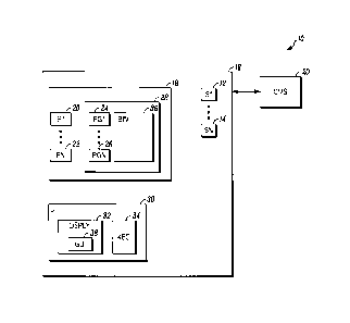
[0009] Fig. 1 illustrates a block diagram of a security system shown
generally in
accordance herewith; and
[0010] Fig. 2 depicts information flow among the processors of FIG. I.
DETAILED DESCRIPTION
[0011] While disclosed embodiments can take many different forms, specific
embodiments thereof are shown in the drawings and will be described herein in
detail
with the understanding that the present disclosure is to be considered as an
exemplification of the principles thereof as well as the best mode of
practicing same,
and is not intended to limit the application or claims to the specific
embodiment
illustrated.
[0012] FIG. 1 is a block diagram of a security system 10 shown generally
in
accordance with an illustrated embodiment. Included within the security system
is a
number of sensors 12, 14 that detect threats within a secured area 16.
[0013] The sensors may be wired or wireless devices intended to detect any
of a
number of different threats to the safety and/or security of humans and/or
assets. For
example, some of the sensors may be fire detection devices (e.g., smoke
detectors,
carbon monoxide detectors, etc.). Others may be intrusion detection devices
(e.g., limit
switches on doors and windows, passive infrared (PIR) detectors, etc.).
[0014] The status of the sensors may be monitored by a control panel 18
located
within the secured area as shown in FIG. 1 or located remotely. Upon
activation of one
of the sensors, the control panel may send an alarm message to a central
monitoring
station 20. The central monitoring station may response by summoning the
appropriate
help (e.g., police, fire, etc.).
[0015] Included within the control panel is control circuitry that
monitors the
sensors. The control circuitry may include one or more processor apparatus
(processors) 20, 22 each operating under control of one or more computer
programs 24,
26 loaded from a non-transitory computer readable medium (memory) 28. As used
herein, reference to a step performed by a computer program is also reference
to the
processor that executed that step.
[0016] Included within the control panel may be an alarm processor that
monitors
a status of each of the sensors. Upon detection activation of one of the
sensors, the
alarm message may compose and send a message to the central monitoring station
- 2 -
CA 02894352 2015-06-15
=
including an address or account number of the secured area, an identifier of
the type of
sensor and its location and a time.
[0017] A user interface 30 may also be provided for control of the
security
system. The user interface may include a display 32 for displaying information
about
the security system and a key board 34 for the input of instructions by an
authorized
user. For example, the user may activate (i.e., arm) certain geographic zones
or
deactivate other zones.
[0018] Upon detection of activation by the control panel of one of
the sensors, an
alert may be shown on the display. The alert may include a map of the secured
area
along with an icon of the activated sensor shown on the map.
[0019] Under one illustrated embodiment, a Building Information
Model (BIM) 36
may be used to simplify and enhance the display of alarm information within
the security
system. The BIM may be embodied as a file of location information. Included
within the
BIM is a set of geographic coordinates that define the secured area and any
building
thereon. In the case of buildings, the BIM defines the three-dimensional
coordinates of
each of the floors including any walls, stairs and points of egress in the
form of one or
more floor plans. The BIM may also include coordinates defining any rooms on
each
floor.
[0020] The BIM also includes textual information explaining the
relationships and
use of various areas within any buildings. For example, the BIM may
superimpose the
word lobby over a lobby or reception area. Similarly, the BIM may include the
words
"Fire Exit" adjacent any fire exits. The BIM may also include floor
designations (e.g.,
first floor, second floor, basement, etc.). Regions may also be identified
within the BIM
(e.g., north wing, north wind of first floor, etc.).
[0021] Under the illustrated embodiment, the information of the
sensors 12, 14 is
automatically incorporated into the BIM. Incorporating the information of each
of the
sensors into the BIM allows the sensors to be superimposed over maps of the
secured
area. For example, a respective icon for each of the sensors may be display on
a floor
plan at the installed location of the sensor. Upon activation of the sensor,
the icon may
be caused to flash or otherwise assume an indication of activation.
[0022] Selection of an icon on a floor plan may be used to
retrieve and display
information about the sensor. Displayed information may include a make and
model of
the sensor as well as a system address and status of the sensor.
[0023] Under the illustrated embodiment, sensor information may be
incorporated
into the BIM using an automated process have first and second parts. Under the
first
- 3 -
CA 02894352 2015-06-15
part, a correlation processor may form a correlation between geographical
information of
the BIM and of the sensors. The correlation processor may retrieve descriptive
information from each of the sensors. An intelligent algorithm executing on a
classification processor may classify each of the sensor devices based upon a
name of
the device configured or otherwise provided by the user.
[0024] Once the devices have been classified, the same or a different
Natural
Language Processor (NLP) processor may process the names to identify
geographic
indicators (e.g., first floor, second floor, etc.) and also functional words
(e.g., fire exit,
lobby, cafeteria, reception, etc.).
[0025] It should be noted in this regard that the BIM will have
information on the
number of the floors and areas present in the building. Most common names are
based
on the floor or direction (e.g., first-north, second-west, etc.).
[0026] Next, the names of the devices are logically mapped or otherwise
correlated with the names of the regions or areas derived from the BIM file by
another
processor. Mapping in this case means grouping names in a hierarchical order.
The
grouping may mean grouping names with relative location (e.g., building #1,
building #2,
first floor, second floor, etc.) into one group, names with direction (e.g.,
north, south,
etc.) together into another sub-group and function names (e.g., lobby,
cafeteria, fire
door, etc.) into still another group. It should be noted that the groups are
not mutually
exclusive. For example, fire doors may exist on several floors.
[0027] Next, a processor may receive the device names and area names from
the
BIM and parse the names to find logical matches. The sensors matched with
areas or
regions of the BIM are placed (displayed) within these areas or regions of a
geographic
display (e.g., floor map) of the secured area. For example, if an access
control door has
been assigned a name of "first floor-north wing-access door" and a doors
sensor has a
name that is matched to that name, then the sensor is mapped into the
corresponding
region in the BIM geographic display.
[0028] Under a second part of the process, a user may add a display site
to a
sensor file and also a location site to the BIM for a first sensor device
before adding any
other devices. The sites may be linked by an identifier of a sensor. This
allows
activation information of the corresponding sensor to be coupled by an alarm
processor
to the geographic display and also for sensor information to be retrieved and
displayed
from the geographic display.
- 4 -
CA 02894352 2015-06-15
[0029] When display information is added to sensor file and to the BIM,
the
device is automatically placed in the corresponding region of the geographic
display of
the BIM. All the operator has to do is to map it into its exact door
equivalent in the BIM.
[0030] For example, a sensor device (e.g., a fire sensor) may be mapped to
a
cafeteria on a first floor of the building. In response, a display processor
may display an
icon of a fire sensor in a region of the cafeteria on the floor plan of a
graphical user
interface (GUI) portion of the display. The user may map the fire sensor to
its installed
location by clicking on the fire sensor and dragging the senor to its exact,
final location.
In response, a location processor may save the coordinates of the final
location in the
BIM along with the system identifier of the sensor.
[0031] FIG. 2 provides a more detailed example of the processes 100 that
occurs
within one or more of the programmed processors described above. For example,
the
user interface 102 receives identifiers or names of each of the sensors from
the user.
The identifiers may be incorporated into one or more sensor files 114, 116. A
comparison processor may receive or retrieve the sensor files from the user
interface.
The comparison processor may also retrieve one or more area files 118, 120
from the
BIM. The area files include functional information about each area defined
within the
BIM. For example, the area files may include a functional description
including text
indicative of the function of the area (e.g., fire door, cafeteria, lobby,
etc.).
[0032] The comparison processor compares 106 the descriptive text of the
sensors with the function text of the BIM. For example, if the user includes a
sensor
with associated descriptive text indicating that it is a fire door sensor and
the
comparison processor finds a functional area named "fire door" within the BIM,
then the
comparison processor will match the fire doors sensor to the functional area
named fire
door.
[0033] This process is repeated until each of the sensors has been matched
to a
functional area within the BIM. For example, the user may have designated a
first fire
sensor with the text "lobby smoke detector" and a second sensor "cafeteria
smoke
detector." Another sensor may have been labeled "loading dock motion sensor."
[0034] Next, a display processor receives the matches and displays 108 the
sensors as a respective icon within a geographic display (e.g., a floor plan)
defined by
the BIM. In the example above of the fire door, an icon of a door open sensor
is
displayed adjacent the fire door. In larger functional areas (e.g., a
cafeteria, loading
dock, etc.), the display processor may simply place the matched sensors in a
center of
the functional area.
- 5 -
CA 02894352 2015-06-15
[0035] It should be noted that in some cases, it may not be possible to
match the
name of a sensor with a functional area. This may be the case where the name
of the
sensor is mis-spelled or when a special purpose sensors are added. In this
case,
sensor that cannot be matched may be displayed along the margins of the floor
plan to
alert the user.
[0036] Once displayed, a location processor may monitor the GUI for
rearrangement of the icons of specific sensors. For example, the user may
place a
cursor over a fire detector in a cafeteria area and drag the icon to the exact
location of
use (e.g., near a kitchen). The location processor may detect the location
where the
icon is deposited as in indication of the final, desired location of the
sensor.
[0037] Once a final destination of the icon is detected, the display
processor may
transfer the final coordinates to a linking processor. The linking processor
may save an
image of the icon in the BIM along with the final coordinates of use of the
sensor.
[0038] The linking processor may also save a set of links (e.g.,
hyperlinks) within
the BIM and also within the alarm processor. The link within the BIM allows a
user to
place a cursor over the icon displayed on a floor plan and click on the icon
to obtain
information about the sensor represented by the icon. The link within the
alarm
processor allows the alarm processor to activate the display processor for
display the
floor plan in response to activation of the sensor where the activated sensor
is shown as
a flashing icon for the benefit of security guards.
[0039] In general, the automated method of using a BIM is a significant
advance
over prior methods. For example, under prior methods, a user would be required
to
drag and drop a sensor into the BIM file or floor plan. In addition, the user
must
manually associate the devices with BIM entities. In a secured area having
numerous
panel and/or devices, this process is laborious and expensive.
[0040] The system of registering sensors is applicable to a number of
different
types of system. Examples include closed circuit television (CCTV) systems,
fire alarm
systems (FAS) and building management systems (BMS) to name a few.
[0041] In general, the system implements a sensor display by executing a
set of
steps including a user input of a security system having a secured area
receiving a
respective name from the user for each of a plurality of security sensors of
the security
system, a processor of the security system matching each of the respective
names to
one of a plurality of respective names of sensor locations within a Building
Information
Model (BIM) of the secured area, the user input receiving from the user a
specific
designation of a corresponding location of each of the plurality of security
sensors within
- 6 -
CA 02894352 2015-06-15
a geographic coordinate system of the BIM, a processor of the security system
correlating each of the respective names with the corresponding location of
the security
sensor within the BIM and a processor of the security system mapping each of
the
plurality of security sensors to a location within the BIM model based upon
the name of
the device.
[0042] The system includes a user input of a security system having a
secured
area that receives a respective name from the user for each of a plurality of
security
sensors of the security system, a processor of the security system that
matches each of
the respective names to one of a plurality of respective names of sensor
locations within
a Building Information Model (BIM) of the secured area, the user input that
receives
from the user a specific designation of a corresponding location of each of
the plurality
of security sensors within a geographic coordinate system of the BIM, a
processor of the
security system that correlates each of the respective names with the
corresponding
location of the security sensor within the BIM and a processor of the security
system
that maps each of the plurality of security sensors to a location within the
BIM model
based upon the name of the device.
[0043] Alternatively, the system includes a user input of a security
system having
a secured area that receives a respective name from the user for each of a
plurality of
security sensors of the security system, a processor of the security system
that matches
each of the respective names to one of a plurality of respective names of
functional
locations within a Building Information Model (BIM) of the secured area, a
graphical user
interface (GUI) that receives from the user a specific designation of a
corresponding
location of each of the plurality of security sensors within a geographic
coordinate
system of the BIM, a processor of the security system that correlates each of
the
respective names with the corresponding location of the security sensor within
the BIM
and a processor of the security system that maps each of the plurality of
security
sensors to a location within the BIM model based upon the name of the device.
[0044] From the foregoing, it will be observed that numerous variations
and
modifications may be effected without departing from the spirit and scope
hereof. It is to
be understood that no limitation with respect to the specific apparatus
illustrated herein
is intended or should be inferred. It is, of course, intended to cover by the
appended
claims all such modifications as fall within the scope of the claims. Further,
logic flows
depicted in the figures do not require the particular order shown, or
sequential order, to
achieve desirable results. Other steps may be provided, or steps may be
eliminated,
- 7 -
CA 02894352 2015-06-15
from the described flows, and other components may be add to, or removed from
the
described embodiments.
- 8 -