Note: Descriptions are shown in the official language in which they were submitted.
CA 02906448 2015-09-14
WO 2014/150927 PCT/US2014/024567
VIRTUAL PROPERTY REPORTING FOR AUTOMATIC STRUCTURE DETECTION
BACKGROUND
[0001] In the remote sensing/aerial imaging industry, imagery may be used
to
capture views of a geographic area in order to measure objects and/or
structures
within the images. These are generally referred to as "geo-referenced images"
and
come in two basic categories:
[0002] Vertical Imagery ¨ images captured with a camera pointed vertically
downward thus generally capturing the tops of structures; and
[0003] Oblique Imagery ¨ images captured with a camera aimed at an angle
capturing the sides, as well as, tops of structures.
[0004] Most vertical imagery may be processed in order to fit a
mathematically
rectangular projection or map. This process is known as ortho-rectification
and
attempts to create an appearance as if the sensor were directly above each
pixel in
the image. The resulting image is known as an ortho-photo. Since the images
are
mathematically projected, they may be combined into a seamless mosaic
resulting in
a composite image known as an ortho-mosaic. The term 'ortho image' is used to
denote a geo-referenced image that is either an ortho-photo image or an ortho-
mosaic image.
[0005] Because they are captured looking straight down, an ortho-photo or
ortho-mosaic contains a view of the world to which many are not accustomed. As
a
result, there may be difficulty in distinguishing between two different
properties (e.g.,
buildings, structures, and/or other man-made or natural objects or features)
as the
only portions of the structures visible in the ortho-mosaic are rooftops. An
oblique
=
image, in contrast, is captured at an angle showing sides of objects and
structures.
Aerial imagery may be used in identification of dimensions of buildings or
structures.
Traditional ortho-rectified imagery has limited use, however, because it
reveals only
the edge of the roof and does not reveal several important aspects of the
building.
SUMMARY
[0006] In one aspect, the inventive concepts disclosed herein are directed
to a
computer system comprising at least one processor capable of executing
processor
executable code operably coupled with a non-transitory computer medium storing
processor executable code, which when executed by the at least one processor
CA 02906448 2015-09-14
WO 2014/150927 PCT/US2014/024567
causes the at least one processor to: (a) receive a first signal over a
computer
network, the first signal indicative of a request for information about a
target structure
from a user; (b) in response to receiving the first signal, access a database
including
information about the target structure; and (c) transmit a second signal over
the
computer network, the second signal indicative of a virtual property report
for the
target structure including at least one image of the target structure.
[0007] The processor executable code when executed by the at least one
processor may further cause the processor to determine using aerial imagery
and at
least one data set indicative of street files information about one or more
of: a facet
of the target structure facing a street, location of a main entrance of the
target
structure relative to the street, location of a secondary entrance of the
target
structure relative to the street, location of vehicle access to the target
structure within
the at least one image, and to store the information in the database and be
associated with the target structure. The processor executable code for
determining
the information may be organized to be executed by the at least one processor
prior
to executing the instructions to receive the first signal. The processor
executable
code when executed by the at least one processor may further cause the
processor
to access the information indicative of the facet of the target structure
facing the
street, and retrieve and display an image of the facet within the virtual
property
report. The processor executable code when executed by the at least one
processor
may also cause the at least one processor to receive a selection of one or
more
pixels within a displayed image of the target structure in which the one or
more pixels
have pixel coordinates, transform the pixel coordinates into real-world
geographic
coordinates, measure distances between the real-world coordinates, and store
the
measurements on a non-transitory computer readable medium within the database
and associated with the target structure, prior to the step of receiving the
first signal
over the computer network. The processor executable code when executed by the
at
least one processor may further cause the at least one processor to associate
a
label identifying the measurement with a particular measurement, and store the
label
with the measurement within the database and associated with the target
structure.
The label identifying the measurement may be a particular field within the
database,
and/or may be selected from the group including orientation and area of a
driveway
depicted within the displayed image, size or area or elevations of a deck
depicted
within the displayed image, location and height of trees adjacent to the
target
2
CA 02906448 2015-09-14
WO 2014/150927 PCT/US2014/024567
structure, areas of windows of the target structure, area of a vertical or
pitched
surface on the target structure, a height of an eave of the target structure,
a height of
a chimney of the target structure, a distance to a church from the target
structure.
[0008] The processor executable code when executed by the at least one
processor may further cause the at least one processor to analyze a parcel
database
to determine an identity of neighboring parcels either adjacent to the target
structure
or within a predefined radius of the target structure, and to make available
to a user
information related to neighboring parcels when accessing information
indicative of
the target structure. The processor executable code when executed by the at
least
one processor may further cause the at least one processor to identify
ownership or
residency of neighboring parcels and to store a link within the database to
information indicative of the owners or residents of neighboring parcels. The
processor executable code when executed by the at least one processor may also
cause the at least one processor to identify social media information of
owners or
residents of neighboring parcels and to store information within the database
indicative of the social media information of the owners or residents of the
neighboring parcels.
[0009] In a further aspect, the inventive concepts disclosed herein are
directed
=
to a non-transitory computer readable medium storing computer executable
instructions that when executed by a processor cause the one or more processor
to
determine data indicative of one or more predetermined features of a target
structure
displayed in an image, the one or more predetermined features selected from: a
facet of the target structure facing a street, location of a main entrance of
the target
structure relative to the street, location of a secondary entrance of the
target
structure relative to the street, orientation and area of a driveway of the
target
structure, location of vehicle access to the target structure, size and area
and
elevations of a deck of the target structure, real-world geographic location
and height
of a tree depicted in the image with the target structure, a geographic
location of a
trunk of a tree depicted in the image with the target structure, an area of a
window of
the target structure, an area of siding (e.g., an area of a wall or portion of
a wall) of
the target structure depicted within multiple aerial images, a height of an
eave of the
target structure, height of a chimney of the target structure, a distance to
one or
more churches from the target structure, and/or social media information of a
neighbor of the target structure.
3
CA 02906448 2015-09-14
WO 2014/150927 PCT/US2014/024567
[0010] In a
further aspect, the inventive concepts disclosed herein are directed
to a computer system comprising at least one processor capable of executing
processor executable code operably coupled with a non-transitory computer
readable medium storing processor executable code, which when executed by the
at
least one processor causes the at least one processor to: (a) receive a first
signal
over a computer network, the first signal indicative of a request for
information about
a target structure from a user; (b) in response to receiving the first signal,
access a
database including multiple aerial images of the target structure; (c)
automatically
identify an aerial image from the multiple aerial images depicting a facet of
the target
structure that faces a street; and (d) transmit a second signal over the
computer
network, the signal indicative of the aerial image of the target structure
depicting the
facet of the target structure that faces the street. The processor executable
code
may further cause the processor to transmit a sequence of third signals
depicting the
multiple aerial images following the transmission of the second signal. The
processor
executable code may also cause the at least one processor to identify the
facet of
the target structure that faces the street by: (1) accessing a file
identifying the street;
(2) projecting a line through at least a portion of a facet of the target
structure to the
street; and (3) identifying the facet that the line is projected through as
the facet of
the target structure that faces the street. The processor executable code may
further
cause the at least one processor to identify a rear facet of the target
structure as a
facet that is positioned at about 1800 relative to the facet of the target
structure that
faces the street.
BRIEF DESCRIPTION OF THE SEVERAL VIEWS OF THE DRAWINGS
[0011] To
assist those of ordinary skill in the relevant art in making and using
the subject matter hereof, reference is made to the appended drawings, which
are
not intended to be drawn to scale, and in which like reference numerals are
intended
to refer to similar elements for consistency. For purposes of clarity, not
every
cornponent may be labeled in every drawing.
[0012] FIG. 1
is a schematic diagram of hardware forming an exemplary
embodiment of a computer system constructed in accordance with the present
disclosure.
[0013] FIG. 2
is a block diagram of an embodiment of one or more host
systems according to the instant disclosure.
4
CA 02906448 2015-09-14
WO 2014/150927 PCT/US2014/024567
[0014] FIG. 3
is a block diagram of an embodiment of one or more memory
according to the instant disclosure.
[0015] FIG. 4
is a flowchart of an exemplary method for determining one or
more physical attributes and dimensions of a foundation of a structure in
accordance
with the present disclosure.
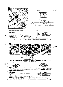
[0016] FIG. 5
is a pictorial representation of an image showing an exemplary
process for detecting location of a structure.
[0017] FIGS. 6-
8 are simplified pictorial representations showing an
exemplary process for defining edges of a structure in accordance with the
present
disclosure.
[0018] FIG. 9
is an exemplary embodiment of a foundation estimate report
presentation page according to the present disclosure.
[0019] FIG. 10
is an exemplary embodiment of a window replacement
estimate report presentation page according to the present disclosure.
DETAILED DESCRIPTION OF EXEMPLARY EMBODIMENTS
[0020] Before
explaining at least one embodiment of the inventive concepts
disclosed herein in detail, it is to be understood that the disclosure is not
limited in its
application to the details of construction, experiments, exemplary data,
and/or the
arrangement of the components set forth in the following description or
illustrated in
the drawings.
[0021] The
inventive concepts disclosed herein are capable of other
embodiments or of being practiced or carried out in various ways. Also, it is
to be
understood that the phraseology and terminology employed herein is for purpose
of
description and should not be regarded as limiting.
[0022] The following detailed description refers to the accompanying
drawings. The same reference numbers in different drawings may identify the
same
or similar elements.
[0023] As used herein, the terms "comprises," "comprising," "includes,"
"including," "has," "having" or any other variation thereof, are intended to
cover a
non-exclusive inclusion. For example, a process, method, article, or apparatus
that
comprises a list of elements is not necessarily limited to only those
elements, but
may include other elements not expressly listed or inherent to such process,
method,
article, or apparatus.
CA 02906448 2015-09-14
WO 2014/150927 PCT/US2014/024567
[0024] As used in the instant disclosure, the terms "provide", "providing",
and
variations thereof comprise displaying or providing for display of a webpage
(e.g.,
structure detection webpage) to one or more user terminals (e.g., an access
point)
interfacing with a computer and/or computer network(s) and/or allowing the one
or
more user terminal(s) to participate, such as by interacting with one or more
mechanisms on a webpage (e.g., structure detection webpage) by sending and/or
receiving signals (e.g., digital, optical, and/or the like) via a computer
network
interface (e,g., Ethernet port, TCP/IP port, optical port, cable modem, a DSL
modem,
POTS modem, and combinations thereof). A user may be provided with a web page
in a web browser, or in a software application, for example.
[0025] Further, unless expressly stated to the contrary, "or" refers to an
inclusive or and not to an exclusive or. For example, a condition A or B is
satisfied by
any one of the following: A is true (or present) and B is false (or not
present), A is
false (or not present) and B is true (or present), and both A and B are true
(or
present).
[0026] In addition, use of the "a" or "an" are employed to describe
elements
and components of the embodiments herein. This is done merely for convenience
and to give a general sense of the inventive concept. This description should
be read
to include one or more and the singular also includes the plural unless it is
obvious
that it is meant otherwise.
[0027] Further, use of the term "plurality" is meant to convey "more than
one"
unless expressly stated to the contrary.
[0028] As used herein any reference to "one embodiment," "an embodiment",
"one example," or "an example" means that a particular element, feature,
structure,
or characteristic described in connection with the embodiment is included in
at least
one embodiment. The appearances of the phrase "in one embodiment" or "one
example" in various places in the specification are not necessarily all
referring to the
same embodiment or example.
[0029] Circuitry, as used herein, may be analog and/or digital, components,
or
one or more suitably programmed microprocessors and associated hardware and
software, or hardwired logic. Also, "components" may perform one or more
functions.
The term "component," may include hardware, such as a processor, an
application
specific integrated circuit (ASIC), or a field programmable gate array (FPGA),
or a
combination of hardware and software. Software includes one or more computer
6
CA 02906448 2015-09-14
WO 2014/150927 PCT/US2014/024567
executable instructions that when executed by one or more component cause the
component to perform a specified function. It should be understood that the
algorithms described herein are stored on one or more non-transient memory.
Exemplary non-transitory memory includes random access memory, read only
memory, flash memory or the like. Such non-transient memory may be
electrically
based or optically based, for example.
[0030] Generally, but not by way of limitation, the inventive concepts
disclosed
herein are directed to computer systems, databases, and methods for visual
insight
for a target location and/or property, stemming from a confluence of
accumulated
relevant data, visualizing imagery, maps, and measurement-based analysis. The
target property or location may be any manmade or natural structure, building,
or
feature. Visual insight according to the inventive concepts disclosed herein
may be
provided to users in the form of virtual property reports including one or
more images
of the property, as will be described in detail herein, for example. Automated
or semi-
automated algorithms may be used to determine any measurements relating to the
target location, and a user or an administrator may review the determination
of the
algorithms and accept or edit the determination, or direct the algorithm to
start over,
for example.
[0031] Referring now to the figures, and in particular to FIG. 1, shown
therein
is an exemplary structure detection system 10 constructed in accordance with
the
present disclosure. System 10 may be a system or systems that are able to
embody
and/or execute the logic of the processes described herein. Logic embodied in
the
form of software instructions or firmware may be executed on any appropriate
hardware. For example, logic embodied in the form of software instructions or
firmware may be executed on dedicated system or systems, or on a personal
computer system, or on a distributed processing computer system, or the like.
In
some embodiments, logic may be implemented in a stand-alone environment
operating on a single computer system and/or logic may be implemented in a
networked environment such as a distributed system using multiple computers
and/or processors exchanging signals over a computer network and/or via one or
more computer ports.
=
[0032] In some exemplary embodiments, system 10 may be distributed, and
include one or more host systems 12 communicating with one or more user
devices
14 via a network 16. As used herein, the terms "network-based," "cloud-based."
and
7
CA 02906448 2015-09-14
WO 2014/150927 PCT/US2014/024567
any variations thereof, are intended to include the provision of configurable
computational resources on demand via interfacing with a computer and/or
computer
network, with software and/or data at least partially located on the computer
and/or
computer network, by pooling processing power of two or more networked
processors.
[0033] In some exemplary embodiments, the network 16 may be the Internet
and/or other network. For example, if the network 16 is the Internet, a
primary user
interface of system 10 may be delivered through a series of web pages. It
should be
noted that the primary user interface of the system 10 may be replaced by
another
type of interface, such as a Windows-based application (e.g., deploying the
system
in a stand-alone environment such as a kiosk).
[0034] The network 16 may be almost any type of network. For example, in
some embodiments, the network 16 may be an Internet and/or Internet 2 network
(e.g., exist in a TCP/IP-based network). It is conceivable that in the near
future,
embodiments of the present disclosure may use more advanced networking
topologies.
[0035] The one or more user devices 14 may include, but are not limited
to
implementation as a personal computer, a smart phone, network-capable
television
set, a television set-top box, a tablet, an e-book reader, a laptop computer,
a desktop
computer, a network-capable handheld device, a video game console, a server, a
=
digital video recorder, a DVD-player, a Blu-Ray player, and combinations
thereof, for
example. In some embodiments, the user device 14 may include one or more input
devices 18, one or more output devices 20, one or more processors (not shown)
capable of interfacing with the network 16, processor executable code, and/or
a web
browser capable of accessing a website and/or communicating information and/or
data over a network, such as the network 16. As will be understood by persons
of
ordinary skill in the art, the one or more user devices 14 may include one or
more
non-transitory computer memory comprising processor executable code and/or
software applications, for example. Current embodiments of system 10 may also
be
modified to use any of these user devices 14 or future developed devices
capable of
communicating with the one or more host systems 12 via the network 16.
=
[0036] The one or more input devices 18 may be capable of receiving
information input from a user and/or processor(s), and transmitting such
information
to the user device 14 and/or to the network 16. The one or more input devices
18
8
CA 02906448 2015-09-14
WO 2014/150927 PCT/US2014/024567
may include, but are not limited to, implementation as a keyboard,
touchscreen,
mouse, trackball, microphone, fingerprint reader, infrared port, slide-out
keyboard,
flip-out keyboard, cell phone, PDA, video game controller, remote control, fax
machine, network interface, and combinations thereof, for example.
[0037] The one or more output devices 20 may be capable of outputting
information in a form perceivable by a user and/or processor(s). For example,
the
one or more output devices 20 may include, but are not limited to,
implementations
as a computer monitor, a screen, a touchscreen, a speaker, a website, a
television
set, a smart phone, a PDA, a cell phone, a fax machine, a printer, a laptop
computer,
a web server, a network interface card or port, and combinations thereof, for
example. It is to be understood that in some exemplary embodiments, the one or
more input devices 18 and the one or more output devices 20 may be implemented
as a single device, such as, for example, a touchscreen or a tablet. It is to
be further
understood that as used herein the term user is not limited to a human being,
and
may comprise, a computer, a server, a website, a processor, a network
interface, a
human, a user terminal, a virtual computer, and combinations thereof, for
example.
[0038] The system 10 may include one or more host systems 12. For
example, FIG. 1 illustrates system 10 having two host systems 12a and 12b
although
a single host system 12 may be included in system 10, or in the alternative,
more
than two host systems 12 may be included in system 10. In some embodiments,
the
host systems 12 may be partially or completely network-based or cloud based.
The
host system 12 may or may not be located in a single physical location.
Additionally,
multiple host systems 12 may or may not necessarily be located in a single
physical
location.
[0039] Each of the host systems 12 may be capable of interfacing and/or
communicating with the one or more user devices 14 via the network 16. For
example, the host systems 12 may be capable of interfacing by exchanging
signals
(e.g., analog, digital, optical, and/or the like) via one or more ports (e.g.,
physical
ports or virtual ports) using a network protocol, for example. Additionally,
each host
system 12 may be capable of interfacing and/or communicating with other host
systems directly and/or via the network 16, such as by exchanging signals
(e.g.,
analog, digital, optical, and/or the like) via one or more ports.
[0040] For simplicity, the host system 12a may be referred to hereinafter
as
the "first host system" and the host system 12b may be referred to hereinafter
as the
9
CA 02906448 2015-09-14
WO 2014/150927 PCT/US2014/024567
"second host system." The network 16 may permit bi-directional communication
of
information and/or data between the first host system 12a, the second host
system
12b, and/or user devices 14. The network 16 may interface with the first host
system
12a, the second host system 12b, and the user devices 14 in a variety of ways.
For
example, the network 16 may interface by optical and/or electronic interfaces,
and/or
may use a plurality of network topographies and/or protocols including, but
not
limited to, Ethernet, TCP/IP, circuit switched paths, and/or combinations
thereof. For
example, in some embodiments, the network 16 may be implemented as the World
Wide Web (or Internet), a local area network (LAN), a wide area network (WAN),
a
metropolitan network, a wireless network, a cellular network, a GSM-network, a
CDMA network, a 3G network, a 4G network, a satellite network, a radio
network, an
optical network, a cable network, a public switched telephone network, an
Ethernet
network, and/or combinations thereof, for example. Additionally, the network
16 may
use a variety of network protocols to permit bi-directional interface and/or
1
communication of data and/or information between the first host system 12a,
the
second host system 12b, and/or one or more user devices 14.
[0041] Referring to FIGS. 1 and 2, in some embodiments, the first host
system
12a may comprise one or more processors 30 working together, or independently
to,
execute processor executable code, one or more memories 32 capable of storing
processor executable code, one or more input devices 34, and one or more
output
devices 36. Each element of the first host system 12a may be partially or
completely
network-based or cloud-based, and may or may not be located in a single
physical
location.
[0042] The one or more processors 30 may be implemented as a single or
plurality of processors working together, or independently, to execute the
logic as
described herein. Exemplary embodiments of the one or more processors 30 may
include, but are not limited to, a digital signal processor (DSP), a central
processing
unit (CPU), a field programmable gate array (FPGA), a microprocessor, a multi-
core
processor, and/or combinations thereof, for example. The one or more
processors
30 may be capable of communicating with the one or more memories 32 via a path
(e.g., data bus). The one or more processors 30 may be capable of
communicating
with the input devices 34 and/or the output devices 36.
[0043] The one or more processors 30 may be further capable of interfacing
and/or communicating with the one or more user devices 14 via the network 16.
For
CA 02906448 2015-09-14
WO 2014/150927 PCT/US2014/024567
example, the one or more processors 30 may be capable of communicating via the
network 16 by exchanging signals (e.g., analog, digital, optical, and/or the
like) via
one or more ports (e.g., physical or virtual ports) using a network protocol.
It is to be
understood, that in certain embodiments using more than one processor 30, the
processors 30 may be located remotely from one another, located in the same
location, or comprising a unitary multi-core processor. The one or more
processors
30 may be capable of reading and/or executing processor executable code and/or
capable of creating, manipulating, retrieving, altering, and/or storing data
structures
into one or more memories 32.
[0044] The one or more memories 32 may be a non-transitory computer
memory capable of storing processor executable code. Additionally, the one or
more
memories 32 may be implemented as a non-transitory random access memory
(RAM), a CD-ROM, a hard drive, a solid state drive, a flash drive, a memory
card, a
DVD-ROM, a floppy disk, an optical drive, and/or combinations thereof, for
example.
[0045] In some embodiments, one or more memories 32 may be located in
the same physical location as the first host system 12a, and/or the one or
more
memories 32 may be located remotely from the first host system 12a. For
example,
one or more memories 32 may be located remotely from the first host system 12a
and communicate with the one or more processors 30 via the network 16.
Additionally, when more than one memory 32 is used, a first memory 32 may be
located in the same physical location as the one or more processors 30, and
additional memories 32 may be located in a remote physical location from the
one or
more processors 30. It should be noted that the physical location(s) of the
one or
more memories 32 may be varied. Additionally, one or more of the memories 32
may
be implemented as a "cloud memory" (i.e., one or more memories 32 may be
partially or completely based on or accessed using the network 16).
[0046] The one or more input devices 34 may transmit data to the one or
more
processors 30 and may include, but are not limited to, implementations as a
keyboard, a mouse, a touchscreen, a camera, a cellular phone, a tablet, a
smart
phone, a PDA, a microphone, a network adapter, and/or combination thereof, for
example. The input devices 34 may be located in the same physical location as
the
one or more processors 30, or may be remotely located and/or partially or
completely network-based.
11
CA 02906448 2015-09-14
WO 2014/150927 PCT/US2014/024567
[0047] The one or more output devices 36 may transmit information from the
one or more processors 30 to a user, such that the information may be
perceived by
the user. For example, the output devices 36 may include, but are not limited
to,
implementations as a server, a computer monitor, a cell phone, a tablet, a
speaker, a
website, a PDA, a fax, a printer, a projector, a laptop monitor, and/or
combinations
thereof, for example. The one or more output devices 36 may be physically
located
with the one or more processors 30, or may be located remotely from the one or
more processors 30, and may be partially or completely network based (e.g.,
website). As described herein, the term "user" is not limited to a human, and
may
comprise a human, a computer, a host system, a smart phone, a tablet, and/or
combinations thereof, for example.
[0048] Referring to FIGS. 1-3, the one or more memories 32 may store
processor executable code and/or information comprising one or more databases
40
and program logic 42. In some embodiments, the processor executable code may
be
stored as a data structure, such as a database and/or a data table in the one
or more
memories 32, for example.
[0049] The second host system 12b may be similar or substantially similar
in
design and concept as the first host system 12a as described herein. The first
host
system 12a may directly communicate with the second host system 12b and/or
communicate via the network 16. Generally, the first host system 12a may
include
one or more processors 30 capable of executing a first set of processor
executable
code and the second host system 12b may include one or more processors 30
capable of executing a second set of processor executable code.
[0050] In some embodiments, the first host system 12a and the second host
system 12b may be independently or cooperatively controlled by separate
entities, or
may be controlled by the same entity. For example, the first host system 12a
may be
controlled by a first company and the second host system 12b may be controlled
by
a second company distinct from the first company. For example, the first host
system
12a may be controlled by an imaging company and the second host system 12b may
be controlled by a building material supplier. The imaging company may be a
separate entity from the building material supplier. Other entities may
control either
the first host system 12a and/or the second host system 12b including, but not
limited to, building contractors, real estate agencies, weather agencies,
community
agencies, home maintenance companies (e.g., gardeners, housekeeping services,
12
1
CA 02906448 2015-09-14
WO 2014/150927 PCT/US2014/024567
window washers, pool maintenance companies, cleaning companies, and/or the
like), federal agencies, state agencies, municipal agencies, schools,
religious
organizations, sport and recreation agencies, insurance agencies, historical
commissions, utility agencies (e.g., water, gas, electric, sewer, phone,
cable,
internet, and/or the like), commercial agencies (e.g., grocery stores, big box
stores,
malls, restaurants, gas/auto service stations, and/or the like), news
agencies, travel
agencies, mapping agencies, and/or the like.
[0051] In general, system 10 may be configured to display and navigate geo-
referenced imagery, such as aerial oblique imagery or aerial orthogonal
imagery,
and/or maps, sketches, and two-dimensional or three-dimensional models (e.g.,
location-centric). The geo-referenced imagery may be represented by a pixel
map
and/or by a series of tiled pixel maps that when aggregated recreate an image
pixel
map. Alternatively, the oblique imagery may be applied to one or more maps
(e.g.,
street or parcel) or two-dimensional or three-dimensional models of
structure(s) 102
depicted within the one or more two or three-dimensional models, rather than
being
applied to an image pixel map, for example. The geo-referenced imagery may be
stored in a database ,40 as one or more electronic files that may be rendered
into a
picture, an image, or a sketch. The electronic files may be in any suitable
image
format (e.g., JPEG, BMP, TIFF, and/or the like).
[0052] The system 10 will be described by way of an example utilizing
aerial
=
geo-reference images as the geo-referenced imagery. However, it should be
understood that system 10 may use other types of geo-referenced images and/or
geo-referenced information, such as architectural images, sketches, street-
view type
images, terrestrial images, and combinations thereof, for example.
[0053] FIG. 4 illustrates a flow chart 70 of an exemplary method for
generally
detecting one or more physical properties of a structure, such as the
structure 102.
[0054] In a step 72, a target address for a particular structure may be
obtained
(e.g., selection on an image, reverse geo-coding an address, performing a
parcel
database look-up). For example, in some embodiments, a user may input a target
address of the property or structure (e.g., the structure 102) in the one of
more user
devices 14. The terms "property" and "structure" may be used interchangeably
with
one another and may include a structure 102, along with surrounding land,
buildings,
structures, or features.
13
1
[0055] FIG. 4 provides an exemplary detailed method 70 for obtaining a
footprint of a foundation of a structure 102 using system and method
illustrated in
FIGS. 1 and 2. System 10 may be described by way of example utilizing aerial
geo-
referenced images as the geo-referenced imagery. However, it should be
understood
that system 10 may use other types of geo-referenced images, such as
architectural
images. In some embodiments, the methods as described herein may be used in
addition to systems and methods as described in U.S. Published Patent
Application
Serial No. 2013/0155109.
[0056] In some embodiments, a user (e.g. customer) may register a user
profile
with the first host system 12a and/or the second host system 12b. The user
profile
may be created and/or stored. For example, the user may be prompted by the
first
host system 12a and/or the second host system 12b to provide login credentials
(e.g.,
username and/or password). Login credentials may allow the first host system
12a
and/or the second host system 12b to authenticate the user. The user profile
may
include information including, but not limited to, demographic information
including,
but not limited to, name, age, address, billing account information, username,
password, behavioral information, experience, gender, and/or the like.
[0057] Referring to FIGS. 4 and 5, in a step 72, a target location may
be
selected for a building or a structure 102. For example, in some embodiments,
a user
may input a target location into one or more user devices 14 by clicking on an
image,
reverse geo-coding an address, performing a parcel database look-up, and/or
the like.
Alternatively, the system 10 may automatically provide a target location. For
example,
the first host system 12a and/or the second host system 12b may provide a
target
location for evaluation without user input.
[0058] In a step 74, the first host system 12a and/or the second host
system
12b may select one or more images containing the target location. In some
embodiments, oblique geo-referenced images may be obtained using oblique
aerial
imagery as described in U.S. Patent No. 7,787,659, U.S. Patent No. 7,873,238,
U.S.
Patent No. 7,424,133, and U.S. Patent No, 5,247,356.
[0059] Further, geo-referenced images may be obtained using oblique
terrestrial imagery. For example, in some embodiments, images may be obtained
using oblique terrestrial imagery if the images are capable of being measured
upon
and/or determined to reveal physical attributes of a structure as described
herein.
14
CA 2906448 2019-03-12
[0060] Geo-referenced images may be images having stored geo-referenced
parameters. For example, geo-referenced images and parameters, when combined
with a ground plane, (as described in U.S. Patent No. 7,424,133) may provide a
determination of pixel location in real world coordinates (e.g., latitude,
longitude) in the
geo-referenced image. Measurements may then be made by calculating a
difference
in pixel location between points of measurement. For example, for distance
measurements, calculations may be determined using circle routes and/or across
a
terrain by tracing a route along a ground plane or between multiple points in
a
structure. Automated or semi-automated algorithms may be used to determine any
of
the measurements, and a user or an administrator may review the measurement of
the algorithms and accept or edit the measurement, or direct the algorithm to
start
over, for example.
[0061] Referring to FIGS. 1, 4, and 5, in a step 76, the first host
system 12a
and/or the second host system 12b may display an image of the target location
on one
or more user devices 14. For example, the target location in FIG. 5 includes
the
structure 102. In some embodiments, the first host system 12a and/or the
second host
system 12b may display the image of the target location on one or more output
devices
36. In some embodiments, multiple geo-referenced images showing multiple
facets of
the structure 102 may be provided. For example, geo-referenced images from
each
cardinal direction (e.g., North, South, East, and West) may be provided for
each
structure 102.
[0062] In some embodiments, the first host system 12a and/or the second
host
system 12b may use an application (e.g., software application) to evaluate
and/or
select the one or more geo-referenced images including the target location
and/or
structure 102. Additionally, in some embodiments, the first host system 12a
and/or the
second host system 12b may use an application to evaluate and/or select
additional
geo-referenced images from other cardinal directions. For example,
determination of
a suitable geo-referenced image for the target location or structure 102 may
be made
by using methods and systems as described in U.S. Patent No. 8,588,547.
Additionally, in some embodiments, the first host system 12a and/or the second
host
system 12b may identify one or more structures 102 in the target location
through a
building detection algorithm.
CA 2906448 2019-03-12
[0063] For example, in a step 80, a user may select the target structure
102 on
the image of the target location using one or more user devices 14 and/or
input devices
34.
[0064] The first host system 12a and/or the second host system 12b may
select
a geo-referenced image (e.g., orthogonal image) displaying a roof or other
physical
attribute of the structure 102, as in step 82.
[0065] In a step 84, the first host system 12a and/or the second host
system
12b may estimate the boundary of the structure 102 from a structure detection
algorithm using systems and methods as described in U.S. Patent No. 8,588,547.
[0066] In a step 86, the first host system 12a and/or the second host
system
12b may select one or more geo-referenced images (e.g., oblique images)
including
one or more facets of the structure 102. In some embodiments, at least one
image for
each cardinal direction may be provided for the structure 102. FIG. 6
illustrates a
simplified view of one facet of the structure 102.
[0067] The first host system 12a and/or the second host system 12b may
run
one or more edge detection algorithms on the one or more geo-referenced images
of
the structure 102, as in step 88. The multiple edge detection algorithms may
include
an edge detection confidence rating. In a step 90, the first host system 12a
and/or the
second host system 12b may store in the one or memories 32 the geo-referenced
information from the image(s), general information about the image(s),
confidence
value(s), and/or the like.
[0068] The first host system 12a and/or the second host system 12b may
compare each edge detection confidence value from each edge detection
algorithm,
as in step 92. The first host system 12a and/or the second host system 12b may
also
classify each edge (e.g., "good," "likely," "unlikely," "discard") based on
the likeliness
to an actual edge of the structure 102, as in step 94.
[0069] In a step 96, the first host system 12a and/or the second host
system
12b may classify each edge based on orientation. For example, edges may be
classified by horizontal edges 104, vertical edges 106, sloped edges 108, and
the like.
[0070] Referring to FIGS. 4-6, the first host system 12a and/or the
second host
system 12b may compare the detected edges to the boundary area, as in step 98.
Detected edges may be limited to those within the boundary area, as in step
100.
16
CA 2906448 2019-03-12
CA 02906448 2015-09-14
WO 2014/150927 PCT/US2014/024567
Additionally, the outermost horizontal edges and the outermost vertical edges
may
be determined. For example, FIG. 7 illustrates the outermost vertical edges
106 of
FIG. 6.
[0071] Referring to FIG. 8, in a step 102, the first host system 12a
and/or the
second host system 12b may determine horizontal edges 104 that meet the
outermost vertical edges 106. Alternatively, the determination may be for
vertical
edges 106 that meet the outermost horizontal edges 104.
[0072] The first host system 12a and/or the second host system 12b may
further determine if multiple facets of the structure 102 exist within the
image, as in
steps 106-114. In some embodiments, however, the first host system 12a and/or
the
second host system 12b may skip the determination of multiple facets and
proceed
to step 116. Determination of facets may be useful in defining property
attributes
such as windows, siding, eaves, and the like, as will be discussed in further
detail
herein. Referring to steps 106-114, in determining facets, the first host
system 12a
and/or the second host system 12b may extrapolate the horizontal edges 104,
vertical edges 106, and/or sloped edges 108 of each facet of the structure
102, as in
step 108. The first host system 12a and/or the second host system 12b may pair
the
vertical edges 106 and/or pair the horizontal edges 104 to determine the
number of
facets of the structure 102 within the boundary area 103 of the image, as in
step 110.
Property attributes (e.g., significant features) of the structure 102 may be
detected,
as in step 112. For example, using pairings of horizontal edges 104, vertical
edges
106, and/or sloped edges 108, windows may be detected on the structure 102.
Additional property attributes may include, but are not limited to, eaves,
siding,
chimney(s), and/or the like.
[0073] In a step 114, the first host system 12a and/or the second host
system
12b may locate geometric vertices of each facet of the structure 102. In some
embodiments, geometric vertices may be determined by an angle of intersection
(0)
between horizontal edges 104 and vertical edges 106. For example, an
intersection
may be approximately ninety degrees relative to each other as in FIG. 8.
[0074] In a step 116, the first host system 12a and/or the second host
system
12b may determine ground location 110 for one or more facets of the structure
102.
In a step 118, the first host system 12a and/or the second host system 12b may
select horizontal edges 104 that connect to the vertical edges 106 parallel to
a
roofline at the lowest point within the boundary area 103. In a step 120, the
first host
17
CA 02906448 2015-09-14
WO 2014/150927 PCT/US2014/024567
system 12a and/or the second host system 12b may compared the ground location
110 with the lowest selected horizontal edge 104 connecting the vertical edge
106 as
determined in step 118. If the horizontal edge 104 is determined to be the
lowest
edge at the ground location 110 or substantially close to the ground location
110, the
horizontal edge 104 may be tagged as a portion of the footprint of the
structure 102,
as in step 124. Alternatively, the first host system 12a and/or the second
host system
12b may connect a horizontal line between vertical edges 106 at the ground
location
110. For example, the first host system 12a and/or the second host system 12b
may
connect a horizontal line between vertical edges 106 at the ground location
110 in a
position parallel to a roofline of the structure 102, as in step 126. The
first host
system 12a and/or the second host system 12b may continue to find each
horizontal
edge 104 at the ground location 110 for the structure as indicated by steps
128 and
130. The first host system 12a and/or the second host system 12b may continue
to
process each image of the structure 102 as indicated by steps 132 and 134.
[0075] Once all horizontal edges 104 of the structure 102 are determined,
the
first host system 12a and/or the second host system 12b may use the horizontal
edges 104 at the ground location 110 to create, provide, and/or store a
footprint of
the structure 102 as indicated by step 136. The first host system 12a and/or
the
second host system 12b may then determine the footprint of the foundation of
the
structure 102 based on the footprint of the structure 102. For example, in
some
embodiments, the footprint of the structure 102 will be the footprint of the
foundation
of the structure 102. Alternatively, the footprint of the foundation may
include
additional portions outside of the range of the footprint of the structure 102
(e.g.,
additional porch or deck square footage). As such, the first host system 12a
and/or
the second host system 12b may additionally manipulate the footprint of the
structure
102. Such additional manipulation may be pre-assigned and/or user initiated.
Automated or semi-automated algorithms may be used to make any of the above
=
determinations and/or measurements, and a user or an administrator may review
the
determinations and/or measurements of the algorithms and accept or edit the
measurement or determination, or direct the algorithm to start over, for
example.
[0076] While an automated procedure is described herein with reference to
FIG. 4, it should be understood that semi-automated procedures may be used for
determining measurements, sketches, and/or three-dimensional models. For
example, the first host system 12a, the second host system 12b, the one or
more
18
CA 02906448 2015-09-14
WO 2014/150927 PCT/US2014/024567
input devices 18, and/or the one or more user devices 14, may be included with
computer readable instructions stored on one or more non-transient memory that
when executed by the one or more processors permit the user to select one or
more
pixels within one or more displayed images indicative of a location of
structure(s),
vertices, and/or other displayed features. The first host system 12a and/or
the
second host system 12b, the one or more input devices 18, and/or the one or
more
user devices 14 may then calculate a three-dimensional location for the one or
more
selected pixels. Further, various types of photogrammetry may be used to
determine
a three-dimensional location of the one or more selected pixels. For example,
stereo
photogrammetry, single image photogrammetry, and/or the like may be used.
[0077] In some exemplary embodiments, the program logic 42 may cause the
first host system 12a and the second host system 12b to cooperate with one
another
to aggregate geo-referenced data and/or to geo-reference and then aggregate
data
in the database 40 to be used for the various reports as will be described
below.
Multiple measurements may be collected and stored in the database 40, to be
provided to users in the form of a virtual property report provided on a
computer
screen as a physical property report provided as an electronic file and/or a
copy or a
printout, for example.
[0078] In some embodiments, the program logic 42 may cause the first host
system 12a and/or the second host system 12b to aggregate geo-referenced data
and/or to geo-reference and then aggregate data in the database 40, and to use
such aggregated data for a variety of property reports which may include
various
compilations of fact-based information aggregated from multiple sources and
presented co-incident with geo-referenced metric oblique imagery, for example.
The
virtual property reports may provide for extensive user interaction and may
allow
users to determine what metric analysis is included in the report, either when
the
report is requested, or at any time while viewing the virtual property report,
and
combinations thereof. For instance, when looking at a property to be insured,
the
inspector may wish to know how far the structure is from the nearest adjacent
structure. The program logic 42 may include an automatic or a semi-automatic
(user
assisted) method or tools for determining this distance with imagery and/or
other
data available to the program and recording the facts and including the facts
in the
subsequently prepared virtual property report(s). Automated or semi-automated
algorithms may be used to make any of the determinations and/or measurements
19
1
CA 02906448 2015-09-14
WO 2014/150927 PCT/US2014/024567
described herein, and a user or an administrator may review the determinations
and/or measurements of the algorithms and accept or edit the measurement or
determination, or direct the algorithm to start over, for example.
[0079] As an example, a potential customer may request a cost estimate
from
a cleaning company to wash the windows of a structure 102. To provide an
accurate
estimate, the cleaning company may wish to determine how many windows are to
be
washed, the area of the windows, the height of the windows above the ground,
access to the windows (e.g., is there any landscaping or shrubbery that would
interfere with the window washing operation), can a ladder be used to reach
upper
level windows, are there any bay windows or recessed dormer windows, are there
insect screens, etc. To that end, the cleaning company may request a window
report
for a structure 102, which may include the above information about the
structure 102,
along with any other pertinent information to enable the cleaning company to
provide
an accurate estimate without physical visitation of the structure 102, for
example.
Further, the cleaning company may benefit from an additional insight regarding
the
structure owner's ability to pay, for example, what is the general affluence
of the area
where the structure 102 is located, what is the assessed tax value of the
structure
102, where do the owners work, and what is their work and/or work title (e.g.,
from
social media information), etc. This information may be provided as a virtual
or
physical property report according to the inventive concepts disclosed herein.
[0080] In one exemplary embodiment, virtual or physical property reports
according to the inventive concepts disclosed herein may help users determine
and
document changes that have occurred over time with respect to a particular
structure
102, property, or a general area such as a city, a park, a neighborhood, a
housing
division, a business or office park, etc. The program logic 42 may include
processor
executable instruction to visually and analytically compare a target structure
102,
property, or location at two periods of time. For example, a virtual property
report
according to the inventive concepts disclosed herein may include a dual-pane
or a
multi-pane viewer to synchronize viewing the same structure 102 or one or more
facets thereof from two different dates. The dual-pane viewer (e.g., a web
page or a
printout) may include user tools to mark changes, measure differences (area of
structure 102 or area of turf grass, etc.). In some embodiments, users may
manually
note the differences, for example. The host system 12a and/or 12b may record a
user's analysis and may insert such analysis into a virtual property report
that
CA 02906448 2015-09-14
WO 2014/150927 PCT/US2014/024567
documents the work, the sources of information and the results, for example.
The
virtual property report may include information such as: how much less green
space
is there now than before, how much taller is the oak tree now than before, did
the
neighbor have the in-ground pool back in 2005, was that back deck on the house
in
2007, and any other measurement and/or property related question that can be
determined from geo-referenced imagery, or from other data sources, for
example,
that is compiled into a database.
[0081] Referring to FIGS. 1, 4 and 9, in some embodiments, a user may be
able to receive a foundation estimate report 200 using the system 10. For
example,
the user may request an estimate for work on the foundation of the structure
102
using one or more user devices 14. In some embodiments, a user may request an
estimate for foundation work using one or more input devices 34 of the first
host
system 12a and/or the second host system 12b. The first host system 12a and/or
the
second host system 12b may use the method as detailed in FIG. 4 to create,
provide, and/or store the footprint of the foundation and/or the dimensions of
the
foundation for the structure 102. In some embodiments, a user may be able to
manipulate results of the method. For example, the user may be able to verify
results
of the footprint, add additional portions and/or details, and/or remove
portions from
consideration.
[0082] The first host system 12a and/or the second host system 12b may
provide a report to the user for the foundation work to be performed on the
structure
102. For example, FIG. 9 illustrates an exemplary foundation estimate report
200.
The foundation estimate report 200 may be distributed using the first host
system
12a and/or the second host system 12b to the one or more user devices 14
and/or
input devices 34. In some embodiments, the report 200 may be distributed to a
third
party system in addition to, or in lieu of, the user. For example, if the user
is a
homeowner, the report 200 may be distributed to the customer and/or to a third
party
system such as a material supplier, insurance company, real estate agency,
home
service company, cleaning company, auditing company, contractors, or the like.
As
used herein "agency" is intended to include an individual, a group of
individuals, a
commercial or charity organization or enterprise, a legal entity (e.g., a
corporation),
an organization whether governmental or private, and combinations thereof.
21
CA 02906448 2015-09-14
WO 2014/150927 PCT/US2014/024567
[0083] The foundation estimate report 200 may include data sets such as
customer information 202, foundation information 204, estimated area detail
206,
and contractor information 208.
[0084] The customer information data set 202 may include the customer
name, customer contact information, and/or the like. The foundation
information data
set 204 may include one or more images of the structure 102. The estimated
area
detail data set 206 may include the total estimated square footage of the
foundation
as determined using the system 10 as described herein.
[0085] The contractor data set 208 may include one or more contractor
names
and/or associated contractor contact information. For example, the contractor
data
set 208 may comprise information about building contractors within a given
geographic location. Each contractor may be associated with a contractor
profile
having information including, but not limited to, business name, contractor
owner
name, address, experience level, specialties performed, insurance coverage,
age of
contractor business, review, or ranking information, and/or the like. For
example, the
contractor data set 208 may include review information. The review or ranking
information may include positive and/or negative feedback relating to each
contractor. For example, the review or ranking information may be based on
prior
customer feedback of customers using the system 10. Review information may
also
be obtained from one or more outside databases (e.g., Yelp, Google review,
and/or
the like).
[0086] In some embodiments, contractors may self-register information with
the first host system 12a and/or the second host system 12b. For example, a
contractor may set-up a contractor profile within the first host system 12a
and/or the
second host system 12b. The contractor profile may have information including,
but
not limited to, business name, contractor owner name, address, experience
level,
age of contractor business, review information, and/or the like.
[0087] In some embodiments, additional data sets may be included within
the
foundation estimate report 200. For example, data sets may include, but are
not
limited to, weather data, insurance/valuation data, census data, school
district data,
real estate data, and/or the like.
[0088] Weather data sets may be created, provided, and/or stored by one or
=
more databases storing information associated with weather (e.g., inclement
weather). A weather data set within the foundation estimate report 200 may
include,
22
CA 02906448 2015-09-14
WO 2014/150927 PCT/US2014/024567
=
but is not limited to, hail history information and/or location, wind data,
severe
thunderstorm data, hurricane data, tornado data, flooding data, and/or the
like. In
some embodiments, the one or more databases including weather information may
be hosted by a separate system (e.g., LiveHailMap.com) and contribute
information
to the first host system 12a and/or the second host system 12b. In some
embodiments, the separate system (e.g., LiveHailMap.com) may be one or the
first
host system 12a or the second host system 12b. The weather data set may be
included within the foundation estimate report 200 and provided to the user
and/or
other parties.
[0089] Insurance and/or valuation data sets may be created, provided,
and/or
stored by one or more databases storing information associated with property
insurance and/or valuation. An insurance and/or valuation data set may
include, but
is not limited to, insured value of the home, insurance premium amounts, type
of
residence (e.g., multi-family, single family), number of floors (e.g., multi-
floor, single-
floor) building type, location relative to recognized hazard zones (wind,
hail, flood,
etc.) , eligibility for special insurance coverage (flood, storm surge),
and/or the like.
The location relative to recognized hazard zones may be measured using a walk-
the-Earth feature along ground planes as described in U.S. Patents Nos.
7,424,133
=
and 8,233,666, for example. Automated or semi-automated algorithms may be used
to make any of the determinations and/or measurements, and a user or an
administrator may review the determinations and/or measurements of the
algorithms
and accept or edit the measurement or determination, or direct the algorithm
to start
over, for example.
[0090] In some embodiments, the one or more databases may be hosted by
a separate system (e.g., Bluebook, MSB, 360Value), and contribute information
to
the first host system 12a and/or the second host system 12b. In some
embodiments,
the one or more databases may be included in the first host system 12a and/or
the
second host system 12b.
[0091] The insurance and/or valuation data set(s) may be included within
the
foundation estimate report 200 and provided to the user and/or other parties.
For
example, during underwriting of a home, an insurance company may request the
foundation estimate report 200 on a home that is recently purchased. The
information within the foundation estimate report 200 may be integrated with
insurance information from an insurance database and used to form a quote
report
23
CA 02906448 2015-09-14
WO 2014/150927 PCT/US2014/024567
The insurance and/or valuation data may be sent to the user and/or to the
insurance
company as part of the foundation estimate report 200, or separately, for
example.
Alternatively, the report 200 may be solely sent to the insurance company with
the
insurance company using the information to formulate an insurance quote.
[0092] In
another example, the report 200 may be used in an insurance claim.
In the case of a property damage and/or loss of a customer, one or more
databases
may be used to create, provide, and/or store an insurance dataset with claim
information in the report 200. For example, an insurance database having a
policy in
force (PIF) and a weather database may be used to correlate information
regarding
an insurance claim for a particular roof. This information may be provided
within the
report 200.
[0093] Real
estate and/or census data sets may also be included within the
one or more of the reports described herein, such as the report 200. The real
estate
and/or census data sets may be created and stored in one or more databases
having detailed information of the structure 102. For example, a real estate
data set
may include, but is not limited to, the homeowner's name, the purchase price
of the
home, the number of times the home has been on the market, the number of days
the home has been on the market, the lot size, the rental history, number of
bedrooms, number of bathrooms, fireplaces, swimming pools, hot tubs, and/or
the
like.
[0094] Real
estate assessment information may also be included within the
real estate data set. Real estate assessment information may include, but is
not
limited to, one or more tools for locating comparable properties to the
structure 102,
tax assessments of similar valued properties, old photos of the structure 102
and/or
adjacent areas, history of the property title (e.g., abstract), prior sales,
prior owners,
rental history, and/or the like.
[0095] The
census data set may include information regarding the number of
residents within the home or structure 102, names and addresses of
neighborhood
or community residents and/or companies, ages of the surrounding population,
gender of the surrounding population, occupations of the surrounding
population,
income level of the surrounding population, public personas, social media
information of neighbors (e.g., social media identities of neighbors, social
media
friends, followers, or connections of neighbors, or other social media profile
information of neighbors, such as pets, favorite music and movies, social
24
CA 02906448 2015-09-14
WO 2014/150927 PCT/US2014/024567
organization membership, hobbies, favorite sports and sport teams,
relationship
status, recent social media posts or status updates, work, profession, work
title, etc.),
presence of convicted felons, sex offender identification, and/or the like. In
some
embodiments, the one or more databases 40 may be hosted by a separate system
(e.g., Core Logic) and contribute information to the first host system 12a
and/or the
second host system 12b to provide data sets as described herein.
Alternatively, the
one or more databases 40 may be integrated within the first host system 12a or
the
second host system 12b.
[0096] In some embodiments, the first host system 12a and/or the second
host system 12b may include logic and/or computer executable instructions to
determine and/or store one or more physical attributes of the structure 102.
Physical
attributes of the structure 102 may include, but are not limited to, the
number and/or
dimensions or areas of windows of the structure 102, the number and/or
dimensions
of doors, the amount and/or percentage of building materials (e.g., siding,
stone,
and/or the like), the dimension of attributes associated with the structure
102 (e.g.,
height of eaves, height and/or dimension of chimney(s), and/or the like),
and/or the
like. Physical attributes may include any attribute that may be measured or
estimated
or calculated by measuring distances between the X, Y, and Z locations of the
geometric vertices and/or selected points by analyzing an aerial or
terrestrial image
with computerized methodologies as described herein. Automated or semi-
automated algorithms may be used to make any of the determinations and/or
measurements described herein, and a user or an administrator may review the
determinations and/or measurements of the algorithms and accept or edit the
measurement or determination, or direct the algorithm to start over, for
example.
[0097] In some embodiments, the first host system 12a and/or the second
host system 12b may determine the number and/or dimensions or area of windows
of the structure 102. For example, referring to FIGS. 1 and 4, in step 108 the
first
host system 12a and/or the second host system 12b may extrapolate horizontal
edges 104, vertical edges 106, and/or sloped edges 108 for each facet of a
structure
102. Horizontal edges 104 may be paired, vertical edges 106 may be paired,
and/or
sloped edges 108 may be paired as in step 110. Pairing of edges may include an
overview of significant features (e.g., physical attributes), such as windows
of the
structure 102. The first host system 12a and/or the second host system 12b may
then locate geometric vertices of the horizontal edges 104, vertical edges
106,
CA 02906448 2015-09-14
WO 2014/150927 PCT/US2014/024567
and/or sloped edges 108, to outline one or more windows of the structure 102.
Dimensions of the one or more windows may be determined by measuring distances
between the X, Y, and Z locations of the geometric vertices and/or selected
points by
analyzing the image data as discussed above, and/or within a separate image.
Area
of the windows may be determined from the dimensions of the windows, for
example. The X, Y, and Z locations may be determined with the techniques
described in U.S. patent No. 7,424,133, for example.
[0098]
Referring to FIGS. 1, 4 and 10, a user may be able to receive a window
replacement estimate report 300 using the system 10. For example, the user may
request an estimate for window replacement of the structure 102 using one or
more
user devices 14. In some embodiments, a user may request an estimate for
window
replacement using one or more input devices 34 of the first host system 12a
and/or
the second host system 12b. The first host system 12a and/or the second host
system 12b may use the methods as detailed in FIG. 4 to create, provide,
and/or
store the number and/or dimensions of the windows for the structure 102. In
some
embodiments, a user may be able to manipulate results of the method. For
example,
the user may be able to use the user device 14 to select the location of the
geometric vertices of the windows to verify windows, remove windows, and/or
add
windows for consideration.
[0099] The
first host system 12a and/or the second host system 12b may
provide the report 300 to the user for the window estimation. For example,
FIG. 10
illustrates an exemplary window replacement estimate report 300. The window
replacement estimate report 300 may be distributed using the first host system
12a
and/or the second host system 12b to the one or more user devices 14 and/or
input
devices 34. In some embodiments, the report 300 may be distributed to a third
party
system in addition to, or in lieu of, the user. For example, if the user is a
homeowner,
the report 300 may be distributed to the customer and/or to a third party
system such
as a material supplier, insurance company, real estate agency, home service
company, cleaning company, auditing company, contractors, or the like.
[00100] The
window replacement estimate report 300 may include data sets
such as customer information 302, structure information 304, estimated number
and/or area detail 306, and contractor information 308.
[00101] The
customer information data set 302 may include the customer
name, customer contact information, and/or the like. The structure information
data
26
1
CA 02906448 2015-09-14
WO 2014/150927 PCT/US2014/024567
set 304 may include one or more images of the structure 102. The estimated
number
and/or area detail data set 306 may provide the total estimated number and/or
dimensions of one or more window of the structure as determined using the
system
as described herein. The contractor data set 308 may include one or more
contractor names and/or associated contractor contact information.
[00102] In some embodiments, additional data sets may be included within
the
window replacement estimate report 300. For example, data sets may include,
but
are not limited to, weather data, insurance/valuation data, census data,
school
district data, real estate data, and/or the like as described herein. For
example, in
some embodiments, the window replacement estimate report 300 may be used in an
insurance claim. In the case of property damage or loss of a customer, the
first host
system 12a and/or the second host system 12b may be used to create, provide,
and/or store an insurance dataset with claim information in the window
replacement
estimate report 300. For example, an insurance database having a policy in
force
(PIF) and a weather database may be used to correlate information regarding an
insurance claim for a particular structure 102 with windows. This information
may be
provided within the window replacement estimate report 300.
[00103] In some embodiments, system 10 may be used to generate a siding
replacement estimate report. The siding replacement estimate report may be
similar
to the foundation estimate report 200 and the window replacement estimate
report
300 described herein. In preparing the siding replacement estimate report, the
first
host system 12a and/or the second host system 12b may determine the dimensions
of siding used on the exterior of the structure 102 including but not limited
to
dimensions and/or areas of distinct sections of the exterior of the structure
102, and
cumulative area of different distinct sections. Referring to FIGS_ 1 and 4, in
step 108
the first host system 12a and/or the second host system 12b may extrapolate
horizontal edges 104, vertical edges 106, and/or sloped edges 108 for each
distinct
facet of the structure 102. Horizontal edges 104 may be paired, vertical edges
106
may be paired, and/or sloped edges 108 may be paired as in step 110. Pairing
of
edges may reveal an overview of significant features (e.g., physical
attributes), such
as the dimensions and/or amount of siding on the exterior of the structure
102. The
first host system 12a and/or the second host system 12b may then locate
geometric
vertices of the horizontal edges 104, vertical edges 106, and/or sloped edges
108 to
outline the dimensions of the siding of the structure 102. Dimensions of the
siding
27
may be determined using analysis of the dimensions of one or more walls of the
structure 102 within the image, and/or within one or more separate images
showing
different parts of the structure 102. In some embodiments the area of a wall
of the
structure 102 may be substantially the same as the area of the siding, while
in some
exemplary embodiment, the area of the siding may be smaller than the area of
the wall
of the structure 102.
[00104] In some embodiments, a user may be able to receive a siding
replacement estimate report similar to the foundation estimate report 200
and/or the
window replacement estimate report 300 of FIGS. 9 and 10. The siding
replacement
estimate report may include data sets, including, but not limited to, customer
information, structure information, estimate details including type, area, and
price of
siding, contractor information, and/or the like. In some embodiments,
additional data
sets may be included within the siding replacement estimate report. For
example, data
sets may include, but are not limited to, weather data, insurance/valuation
data,
census data, school district data, real estate data, and/or the like as
described herein.
[00105] In some embodiments, system 10 may be used to generate a roofing
report. The roofing report may be similar to the foundation estimate report
200 and the
window replacement estimate report 300 described herein.
[00106] Referring to FIGS. 1 and 4, the first host system 12a and/or the
second
host system 12b may determine the height of eaves of the structure 102. For
example,
in step 108 the first host system 12a and/or the second host system 12b may
extrapolate horizontal edges 104, vertical edges 106, and/or sloped edges 108
for
each facet of a structure 102. The first host system 12a and/or the second
host system
12b may then determine horizontal edges 104 located at the peak of the
structure 102
using the methods described in FIG. 4, to determine the location and
dimensions of
the eaves of the structure 102. In some embodiments, eaves location may be
determine using the systems and methods as described in U.S. Patent No.
8,977,520.
The height of the eaves of the structure 102 may then be determined by
approximating
the distance from a ground level. For example, the height of the eaves of the
structure
102 may be determined by using a single image and a ground plane as described
in
U.S. Patents Nos. 7,424,133 and 8,233,666.
28
CA 2906448 2019-03-12
Other techniques, such as aero triangulation using overlapping images, may
also be
used.
[00107] In addition to, or in lieu of the height of the eaves, the pitch
of the roof
may be included within a report. In some embodiments, the pitch of the roof
may be
determined using systems and methods as described in U.S. Patent No.
9,183,538.
[00108] In some embodiments, the system 10 may be used to generate a
chimney report. The chimney report may be similar to the foundation estimate
report
200 and the window replacement estimate report 300 described herein.
[00109] Generally, the first host system 12a and/or the second host
system 12b
may determine the number and dimensions (e.g., height, width, length, and
area) of
one or more chimneys of the structure 102. For example, referring to FIGS. 1
and 4,
in step 108 the first host system 12a and/or the second host system 12b may
extrapolate horizontal edges 104, vertical edges 106, and/or sloped edges 108
for
each facet of a structure 102. The first host system 12a and/or the second
host system
12b may then determine pairings of vertical edges 106 rising towards and past
the
peak of the structure 102 using the methods described in FIG. 4, to determine
the
location and dimensions of the one or more chimneys of the structure 102. The
number
and dimensions of the one or more chimneys may be provided in a report similar
to
the foundation estimate report 200 and/or the window replacement report 300.
For
example, a report may be provided for a customer requesting cleaning of one or
more
chimneys, demolition of one or more chimneys, and/or the like. Alternatively,
a report
(including any of the reports described herein) may be provided to a property
tax
assessor, insurance agency, real estate agency, and/or the like, informing of
the
number and dimensions of one or more chimneys of the structure 102.
[00110] The methods as described and illustrated in FIG. 4 create,
provide
and/or store an outline the structure 102 preferably including one or more
physical
attributes of the structure 102 (e.g., windows, doors, chimneys, siding,
eaves, and/or
the like). As such, a sketch of the structure 102 may be provided in some
embodiments. The sketch may be used as an image of the structure 102 within
many
industries including, but not limited to, building contractor companies, real
estate
agencies, weather agencies, community agencies, home maintenance companies
(e.g., gardeners, maid services, window washers, pool maintenance companies,
and/or the like), federal agencies, state agencies, municipal agencies,
schools,
29
CA 2906448 2019-03-12
religious agencies, sport and recreation organizations, insurance agencies,
historical
commissions, utility agencies (e.g., water, gas, electric, sewer, phone,
cable, internet,
and/or the like), commercial agencies (e.g., grocery stores, big box stores,
malls,
restaurants, gas/auto service stations, and/or the like), news agencies,
travel
agencies, mapping agencies, and/or the like.
[00111] In some embodiments, the sketch may include a three-dimensional
model. The three-dimensional model may be the basis of a virtual property
model
containing not only information about the exterior of the structure 102, but
may also
include further information including, but not limited to, room layout, living
areas, roof
layout, and/or the like. Such information may be included in the real estate
arena
and/or building arena. For example, multiple data sources may be attached to
the
model to include bids for remodeling and/or the like. Some examples may be
found in
European Application No. 99123877.5.
[00112] In some embodiments, the sketch, three-dimensional model, and/or
additional information may be used to acquire or to apply for any building
permits
and/or variances (e.g., zoning variances, fence building permits, water well
digging
permits, septic system construction permits, pool construction permits, etc.),
for
example. The sketch or model of the structure may be transmitted or otherwise
provided to a permit-issuing agency as a part of a permit request (e.g., as a
permit
request report or request), to allow the permit-issuing agency to process the
permit
request without having personnel go out to the physical location of the
structure 102,
or by allowing personnel to defer or delay a site visit, or to avoid a phone
call or
substantially obviate the need for the permit requesters to submit additional
information, for example. In some exemplary embodiments, the permit requester
may annotate an image or sketch of the structure to show requested changes or
structures to be built or removed, geo-referenced location of visible or
underground
utilities, compliance with zoning codes, fire codes, geo-referenced property
boundaries, and any other relevant annotations to enable the permit-issuing
agency
to evaluate the permit request without physical visitation to the structure
102, for
example. As will be appreciated by persons of ordinary skill in the art, an
annotated
permit or variance application according to the inventive concepts disclosed
herein
includes substantially precise geo-referenced locations of proposed features
to be
CA 2906448 2019-03-12
CA 02906448 2015-09-14
WO 2014/150927 PCT/US2014/024567
added to or removed from the property and/or the structure 102. Such geo-
referenced location may show the actual location of the features, thus
enabling the
permit board, variance board, or zoning board members to consider and decide
on
the application by virtually visiting the structure 102, and without
physically visiting
the structure 102 as is the current practice of such boards. In this example,
the
sketch, three-dimensional model, or the like, can be prepared by a first user
of the
system and then transmitted to a second user of the system. The first user can
be
the permit requester, for example, and the second user can be a person(s)
working
at the permit-issuing agency.
[00113] In some embodiments, for example within the real estate industry,
the
sketch and/or three-dimensional model of the structure 102 may be used as a
virtual
tour for prospective buyers. The models may be obtained using the techniques
as
described herein. Additional information and/or photographs of the interior of
the
structure 102 may be used to model the interior of the structure 102 and used
to
create, provide, and/or store a virtual tour of the structure 102.
[00114] The methods, as described and illustrated in FIG. 4, may also apply
to
areas about the structure 102. For example, property about the structure 102
may be
analyzed using the system 10 and techniques described herein. Such property
attributes and/or land attributes may include, but are not limited to, size
(e.g.,
acreage) of the property, dimensions of the property, easements and/or rights
of way
on the property, flood zone of the property, proximity to major roadways,
proximity to
railways, and/or the like. Alternatively, property or structure 102 attributes
may be
determined using a third party source and/or stored within the first host
system 12a
and/or the second host system 12b. Such property attributes may be added into
information by the methods described herein. For example, acreage of property
associated with the structure 102 may be added into one or more reports as
described herein. In another example, the sketch may include locations of the
structure 102 in relation to property attributes (e.g., easements, rights of
way,
dimensions of the property, flood zones, and/or the like).
[00115] Information regarding the structure 102 and/or the property, as
described herein, may be used to create, provide, and/or store information
and/or
reports within the home maintenance arena. For example, the methods and
systems
as described herein may provide information regarding the dimensions of one or
more areas of turf on the property of the structure 102 (e.g., front yard,
back yard,
31
CA 02906448 2015-09-14
WO 2014/150927 PCT/US2014/024567
side yard, mulch beds, flower beds, gardens, and the like), the dimensions of
one or
more gardens, the area and/or dimensions of one or more trees, the shade
pattern of
one or more trees, the actual X, Y, Z location of where a tree trunk
intersects the
ground, the height of a tree, the shade pattern of a tree (e.g., displayed as
darkened
lines and/or areas), the dimensions and area of one or more driveways, the
number
and area of windows, the dimensions of one or more gutters, the dimensions
and/or
depth of one or more pools (or height of above-ground pools), the dimensions
of one
or more decks (e.g., whether the decks are single-level, or multi-level, and
the
height, dimensions, and area of each level, including the height and length of
deck
railing), and/or the like. Such attributes may be generated by receiving a
selection of
one or more pixels in a displayed image and transforming the pixel
coordinate(s)
within the image to real-world geographic coordinates, and then further
associating
data such as labels or the like to the real world coordinates. The attributes
may be
added into information or virtual property reports described herein and/or
provided in
a single report using the methods described herein. For example, a report may
be
generated by a landscaping agency to include an estimate for lawn or
landscaping
maintenance. A first user (e.g., homeowner) may request a lawn maintenance
estimate using user devices 14, and a second user of the landscaping agency
may
(1) create, (2) provide, and/or (3) store the measurement data in a database
with a
geographic indicator, such as an address, and then (4) generate a report using
one
of the user devices 14 and/or the first host system 12a and/or the second host
system 12b as described herein. Such report may be generated without physical
visitation of personnel of the landscaping agency to the structure 102. In
addition, the
measurement data may be addressed and/or accessed by a user using a program,
such as a database program or a spreadsheet program. In addition, the
measurement data can be saved as a digital worksheet (e.g., Microsoft Excel)
file or
an XML file, for example.
[00116] Construction information regarding the structure 102 and/or
property
may also be included in one or more reports, such as a virtual property report
as
described herein. For example, construction information may include, but is
not
limited to, size and slope of the roof, size and slope of the driveway,
bearing of the
driveway, shade patterns from adjacent structures and/or trees, and/or the
like. Such
information may be obtained using the methods as described in FIG. 4. For
example,
shade patterns of structures and/or trees may include lines within an image
(e.g.,
32
CA 02906448 2015-09-14
WO 2014/150927 PCT/US2014/024567
darkened areas). The height of trees and the location where the tree trunk
intersects
the ground may be determined by suitable computational measurement technique,
or correlating pixel coordinates to real-world coordinates, and may be
included in the
report. The footprint of the area may be determined by the darkened areas of
the
image. As such, the shade pattern may be created, provided, and/or stored
using the
first host system 12a and/or the second host system 12b as described herein.
Shade
information, in some embodiments, may include estimations for solar energy
orientation and/or potentials. For example, a solar energy estimation report
may be
created, provided, and/or stored using the footprint of the area of the shade
pattern.
The report may be similar to the footprint estimation report 200 and/or the
window
replacement estimate report 300.
[00117] In some embodiments, information obtained by using the methods as
described herein may be used by municipalities, users within the municipality,
and/or
users seeking information regarding structures 102 and/or land within the
municipality. For example, using the methods of FIG. 4, boundaries (e.g.,
footprints)
may be determined for counties, schools, cities, parks, churches (location and
denominations), trails, public transit lines, and/or the like. Additionally,
three
dimensional models and/or sketches may be created, provided, and/or stored for
such counties, schools, cities, parks, trails, youth sports facilities, public
swimming
pools, libraries, hospitals, law enforcement, hospitals, fire stations, and/or
the like. In
some embodiments, the models and/or sketches may provide viewings of
structures
102 and/or physical attributes of land surrounding the properties. Also,
distance
between structures 102 may be estimated using techniques as described herein
and
may be measured along ground planes as described in U.S. Patents Nos.
7,424,133
and 8,233,666, for example. As such, location and/or distances between
municipal
facilities may be provided to a user.
[00118] In one example, school or school zone boundaries may be determined
using modeling of structures (e.g., 2-dimensional and/or 3-dimensional) within
the
municipality. Modeling of structures may include an estimation of dimensions,
number of structures 102, and/or the like. This information may be used to
determine
feasibility of altering school boundaries, feasibility in adding one or more
schools
and/or school systems, reporting of existing school boundaries, and/or the
like.
[00119] In another example, zoning ordinances may be determined and/or
enforced using structure modeling. For example, a homeowner may build a
specific
33
CA 02906448 2015-09-14
WO 2014/150927 PCT/US2014/024567
structure (e.g., pool), and report or file with the city certain dimensions
subject to the
zoning ordinances of the municipality. Using the systems and methods as
described
herein, the municipality may be able to view the pool and measure dimensions
of the
pool (e.g., size, orientation, or depth for aboveground pools) for compliance
without
physical visitation to the structure 102.
[00120] In some embodiments, municipal rendering may include mapping for
special districts within a municipality. For example, obtaining footprints,
models,
and/or sketches of structures 102 may aid in grouping of structures 102 for
fire and
public protection. Using the methods as described herein, measurements may be
included for each structure 102 and land surrounding the structures 102 such
that
distance measurements may be obtained and used to create, provide, and/or
store
mapping for such special districts (e.g., fire, public protection,
congressional districts,
electoral districts, and the like). Distance measurements may be determined
along
ground planes as described in U.S. Patents Nos. 7,424,133 and 8,233,666, for
example.
[00121] In one example, an election report may be generated using mapping
of
the municipality. The election report may include information including, but
not
limited to, officials within one or more districts (e.g., local, county, state
and/or
federal officials) demographics of the one or more districts, distance of a
point of
interest to the one or more districts, location of municipal facilities,
polling locations,
distance to polling locations from a point of interest, images of polling
locations,
and/or the like. The election report may be similar to the foundation estimate
report
200 and the window replacement report 300.
[00122] In one example, mapping structures 102 and land using the methods
described herein may be used to create and/or electronically store in one or
more
databases 40 one or more models for sewer, lighting, and/or other public
works. For
example, mapping structures 102 and land may be used to create, provide,
and/or
store a three-dimensional model with associated dimensions. The three-
dimensional
model with associated dimensions may be used to plan for additional sewage
lines
and/or replacement/removal of sewage lines, in one example. With mapping, an
estimation regarding feasibility, building materials, and/or the like may be
created,
provided, and/or stored prior to physical visitation to the area (e.g.,
structure and/or
land).
34
CA 02906448 2015-09-14
WO 2014/150927 PCT/US2014/024567
[00123] Information regarding utility connections and services may also be
used to create, provide, and/or store a utility report using the systems and
methods
as described herein. For example, utility connections may be a physical
attribute of a
structure 102 identified using methods described herein. As such, the location
of
visible utility connections may be made. Additionally, the location of hidden
utility
services may be identified using structures and land analysis in conjunction
within
one or more databases having hidden utility location information. In some
embodiments, hidden utility services may be determined solely using
identification of
physical attributes on the land and/or structures. For example, using the
system and
methods as described herein, physical attributes including, but not limited
to, water
shut off valves, sewer shut off valves, utility lines, meters, manhole covers,
drains,
overhanging lines, poles, and/or the like, may be identified and/or measured.
From
these physical attributes, hidden utility lines may be identified using the
image and
techniques described herein, including, but not limited to, gas, electric,
sewer, water,
phone, cable, internet, and/or the like. In some embodiment, additional
information
about the utility lines may be identified and stored in the database 40 by
modeling
and/or use of one or more outside databases. For example, the grade, size,
capacity, and/or consumption of utility lines may be determined by the systems
and
methods as described herein, and/or included by one or more databases 40.
[00124] Using the methods as described in FIG. 4, for example, distance
between structures 102 and/or land may be determined. Using this information,
distance between structures 102 and/or land may be used in applications
including,
but not limited to, driving and/or commute time between places of interest,
distances
between and/or to retail environments (e.g., grocery stores, big box stores,
mails,
restaurants, gas/auto service stations), distance to hospitals, distance
and/or time for
fire and/or emergency response, distance between schools (e.g., zoning,
boundaries), distance between churches (e.g., by denomination), and the like.
Such
distances may be provided to the user using the user device 14.
[00125] In one example, an emergency service report may be created and
=
provided to a user. The emergency service report may include, but is not
limited to,
distance from a point of interest to one or more hospitals, distance for fire,
ambulance, and/or police response to a point of interest, the type of law
enforcement
within a geographic area surrounding the point of interest, and/or the like.
The
emergency service report may be incorporated into any of the previous reports
1
CA 02906448 2015-09-14
WO 2014/150927 PCT/US2014/024567
described herein or transmitted or provided as a standalone report. For
example, the
emergency service report may be similar to the foundation estimate report 200
and
the window replacement report 300.
[00126] In one example, distances between churches (e.g., by denomination)
may be measured and provided to a user. For example, system 10 may provide a
church report including, but not limited to, locations of one or more
churches,
denominations of the one or more churches, distance from a point of interest
to the
one or more churches (e.g., user's residence), zonal boundaries of churches
(e.g.,
parish boundaries), photos of the one or more churches, and/or the like. The
church
report may be similar to the foundation estimate report 200 and the window
replacement estimate report 300.
[00127] Similarly, system 10 may provide a school report similar to the
church
report. The school report may include, but is not limited to, locations of one
or more
schools, age range of the one or more schools, ratings of the one or more
schools,
photos of the one or more schools, zonal boundaries of the one or more
schools,
and/or the like. Similar reports may be provided for parks, sports centers,
youth
sports practice facilities (e.g., soccer, baseball, football, basketball),
youth sports
associations and location of facilities, swimming pools (e.g., private and/or
public),
and/or the like.
[00128] In one embodiment, one or more databases may include information
regarding registry of sex offenders, including addresses of sex offenders.
This
information may be used in conjunction with the distance between structures
and/or
land to provide distance measurements from a place of interest to one or more
addresses of one or more sex offenders. For example, a place of interest may
be a
proposed or existing school. The distance between the school and the one or
more
addresses of one or more sex offenders may be provided to a user in a sex
offender
report. The sex offender report may include, but is not limited to, one or
more
pictures or one or more sex offenders within a geographic area, addresses of
the
one or more sex offenders, criminal history of the one or more sex offenders,
distance between the place of interest and the one or more sex offenders,
sketches
of one or more structures inhabited by the one or more sex offenders and/or
the like.
In some embodiments, information such as community crime statistics, criminal
record checks of neighbors, and/or the like, may be included within the sex
offender
36
CA 02906448 2015-09-14
WO 2014/150927 PCT/US2014/024567
report, a separate report, a report described herein, and/or any other similar
reporting.
[00129] In some embodiments, using the system and methods as described
herein, traffic flow may be determined and/or improved. In one example, a road
may
be mapped and/or modeled using the system and methods described herein.
Traffic
count may be made either physically on-site and/or using the system and
methods
as described herein. Using the traffic count and modeling of the road, traffic
flow may
be determined, altered, and/or improved. For example, for improvement, the
model
may be used to further include a base for developing additional routes (e.g.,
roads)
in the area to ease traffic congestion. Modeling structures and land
surrounding the
road may further include additional information regarding development of
additional
routes.
[00130] In some embodiments, the systems and methods as described herein
may be used for a property tax assessment. For example, using the methods as
described in FIG. 4, physical attributes of the structure 102, and the
structure 102
itself, may be determined, including distances, areas, and dimensions. A
sketch
and/or model may be determined for the structure 102 as well. The measurements
and sketch may be used in a property tax assessment report similar to the
foundation estimate report 200 and the window replacement estimate report 300.
The property tax assessment report may include the sketch and/or model of the
structure 102 and/or property, physical attributes of the structure 102 and/or
property
(e.g., grade, condition, dimensions, and/or the like), details of the assessed
value of
the structure 102 and/or property, current and/or historic values of the
property (e.g.,
based on taxes, market value, and/or the like), additional imagery included by
the tax
assessor, a tax map, and/or other similar features.
[00131] In some embodiments, the system and methods as described herein
may be used in formulation of an insurance report. The insurance report may be
similar to the foundation estimate report 200 and the window replacement
estimate
report 300. The insurance report may include risks of weather hazards, maps of
weather hazard risks, insurance ratings of structures and/or land, prior claim
history
for structures 102 and/or land, information from the emergency service report
and/or
the utility report discussed above, and/or the like. Using the methods as
described in
FIG. 4, distances of hazards and/or to hazards may be determined in some
embodiments. Additionally, the square footage of the entire structure 102
and/or
37
CA 02906448 2015-09-14
WO 2014/150927 PCT/US2014/024567
portions of the structure 102 may be determined. Based on the square footage,
replacement cost estimates may be generated for replacement by total square
footage or living area and included within the insurance report, for example.
[00132] In some embodiments, using the methods as described in FIG. 4, for
example, the program logic 42 may include instructions to determine and report
the
orientation of a facet of the structure 102 relative to a street, by
determining which
facet of the structure 102 faces the street and/or is the front of the
structure 102. For
example, determining which facet faces the street may be carried out by
determining
a center of the structure 102, projecting a line connecting the center of the
structure
to a known location of the street address of the structure, and designating a
facet
positioned between the center and the street with which the line intersects as
the
street-facing facet. As described above, the program logic may determine the
X, Y,
and Z location of the corner of the structure 102. The center of the structure
102 may
be determined by averaging the X coordinates of each corner and the Y
coordinates
of each corner of the structure 102. The known location on the street where
the
street address of the structure 102 is located may be obtained from a separate
database, such as the T.I.G.E.R. (Topologically Integrated Geographic Encoding
and
Referencing) database, for example.
[00133] In an exemplary embodiment, determining which facet of the
structure
102 faces the street may be carried out by selecting a facet that is
substantially
parallel or angled at a predetermined angle relative to the street. The
predetermined
angle may be substantially perpendicular to the street, or any other desired
angle.
An automated or semi-automated algorithm may be used to determine the front of
the structure, and a user or an administrator may review the determination of
the
algorithm and accept or edit the determination, or direct the algorithm to
start over,
for example. Information identifying the front of the structure 102 can be
used for a
variety of different transformative or analysis applications. For example, the
image of
the determined front facet of the structure 102 may be retrieved and displayed
as the
initial or default view of a virtual property report according to the
inventive concepts
disclosed herein, including the location of the main or front entrance to the
structure,
for example. Further, a street access to the structure 102 may be identified
for law-
enforcement or emergency services accessing the database 40, to include a main
entrance for personnel, a back or side entrance, a driveway, alleyway, or
street
access for vehicles, and combinations thereof, for example. The front of the
structure
38
CA 02906448 2015-09-14
WO 2014/150927 PCT/US2014/024567
102 and/or information about vehicle or personnel access to the property
and/or
structure 102 may be stored in the database 40, and may be provided as part of
a
virtual property report, for example. Similarly, the back of the structure 102
may be
determined to be the facet that is offset by about 1800 from the determined
front of
the structure 102 as will be appreciated by persons of ordinary skill in the
art.
[00134] The determined front and back facets of the structure 102 may be
included in a variety of virtual property reports according to the inventive
concepts
disclosed herein, such as an emergency response report showing the street
access
for vehicles to the structure 102 and/or the property surrounding the
structure (e.g.,
where the street address location of the structure 102 does not correspond to
the
location of a driveway or entryway into the structure 102), the location of a
main
personnel entrance to the structure 102, the location of a secondary or back
entrance to the structure 102, the location of nearby fire hydrants,
overhanging
power or utility lines, etc., to enable emergency personnel to determine the
best way
to access the structure and respond to an emergency, such as medical
emergencies, police emergencies, fires, floods, earthquakes, gas leaks,
tornados,
and other emergency situations, for example.
[00135] Using the methods as described in FIG. 4, for example, the program
logic 42 may also include instructions to determine and report changes to
structures
102 and/or land. The program logic 42 may include instructions, that when
executed
by the first and/or second host systems 12a and 12b cause the first and/or
second
host systems 12a and 12b to store the following information in the database(s)
40:
the location of one or more structures 102 (such as by address, or latitude
and
longitude, for example) measurements of the structures 102 and/or the land,
identities of the measurements (such as height to eave, area of roof, length,
width, or
area of front flower bed, etc.) as well as the date in which the
measurement(s) are
taken. This can be accomplished by the database 40 having one or more tables
with
predetermined fields (e.g., area of roof field, height to eave field, length
of front
flower bed field, length of rear flower bed field, number of windows field,
etc.) to store
the measurements. For example, the structure 102 can be detected and/or
measured on a first date, e.g., January 1, 2011, and data indicative of the
measurement type and date stored in the database 40. The same structure 102
can
be detected and/or measured on a second date, e.g., January 1, 2012, and the
measurements, measurement type, and date stored. The system may detect
39
CA 02906448 2015-09-14
WO 2014/150927 PCT/US2014/024567
differences in the size, location, dimensions, or appearance of any objects or
structures between the two times, and combinations thereof, for example. The
first
and/or the second host systems 12a and 12b can be programmed to periodically,
randomly, and/or with user activation, check for any differences in the
measurements
of the structure 102. If differences in measurements above a predefined amount
(e.g., 0%, 5% or the like) are determined, a change report identifying the
structure(s)
102 and the changes can be prepared and output by the first and/or second host
systems 12a and 12b to one or more of the user devices 14 as a web page, form
and/or a computer file.
[00136] The system 10 may be used by humans operating the user devices 14
to view and measure an object, such as the structure 102 and/or the land, in
an
oblique and/or ortho-image using image display and analysis software, as
described
for example in U.S. Patent No. 7,424,133; and U.S. Patent Application No. 2012-
0101783. The program logic 42 can include instructions for storing the
structure
measurement information into the database(s) 40 with or without the users
knowing
that the measurements are being stored. The structure measurement information
may include the following: the location of one or more structures 102 (such as
by
address, or latitude and longitude, for example) measurements of the
structures 102
and/or the land, measurement type (such as height to eave, area of roof,
length of
front flower bed, etc.) as well as the date in which the measurement(s) are
taken.
This can be accomplished by providing a web page to the user's user device 14
requesting the user to assign a measurement type to the measurement. For
example, a field on a web page or form can be provided with a predetermined
list of
measurement types such as area of roof, height to eave, length of lot, or the
like and
a button on the web page or form can be used by the user to indicate that a
measurement type has been selected. Alternatively, the image and the
measurement can be automatically provided by the first and/or the second host
systems 12a and 12b to another user device 14 to be viewed by another user,
who
assigns and stores a measurement type to the measurement using the user device
14. The first and/or the second host systems 12a and 12b receive and store the
measurement and measurement type in the database(s) 40. Automated or semi-
automated algorithms may be used to make any of the determinations and/or
measurements described herein, and a user or an administrator may review the
CA 02906448 2015-09-14
WO 2014/150927 PCT/US2014/024567
determinations and/or measurements of the algorithms and accept or edit the
measurement or determination, or direct the algorithm to start over, for
example.
[00137] It should be noted that the inventive concepts disclosed herein are
capable of other embodiments or of being practiced or carried out in various
ways.
For example, several embodiments include one or more data sets. Each data set
may be included solely in that report, or be included in one more other
reports as
described herein. For example, the change report can be combined with the roof
report, or the assessment report to provide the user with information
regarding the
current and historical measurements of the structure 102. Additionally, data
sets
within each report may stand-alone. For example, the real estate data set may
be a
stand-alone report not associated with other reports as described herein. It
should
also be noted that although "reports" are generated herein, such information
need
not be distributed in the form of a report. For example, the system 10 may
determine
there are 3 chimneys and distribute this information solely without inclusion
within a
"report."
[00138] From the above description, it is clear that the inventive concepts
disclosed and claimed herein are well adapted to carry out the objects and to
attain
the advantages mentioned herein, as well as those inherent therein. While
exemplary embodiments of the inventive concepts have been described for
purposes
of this disclosure, it will be understood that numerous changes may be made
which
will readily suggest themselves to those skilled in the art and which are
accomplished within the broad scope and spirit of the inventive concepts
disclosed
herein and/or as defined in the appended claims.
41