Note: Descriptions are shown in the official language in which they were submitted.
CA 02907569 2015-09-17
WO 2014/153321
PCT/US2014/030971
1
EMERGENCY RESPONSE SYSTEM AND METHOD
CLAIM OF PRIORITY
The present application is based on and a claim to
priority is made under 35 U.S.C. Section 119(e) to provisional
patent application currently pending in the U.S. Patent and
Trademark Office, having Serial No. 61/803,973 and a filing
date of March 21, 2013, the entirety of which is incorporated
herein by reference.
BACKGROUND OF THE INVENTION
Field of the Invention
This invention is directed to an improved emergency
response system and method for use in responding to
emergencies at various premises such as homes, businesses,
neighborhoods, campuses, etc. An
emergency dispatcher, or
electronic equivalent, can reference designated directional
zones to relay important directional information regarding a
target location to first responders, regardless of whether
additional premises-related information is immediately
available. In
addition, the zones can be displayed in a
superimposed manner relative to mapped features of the local
premises, such as satellite photos, site maps, architectural
plans, etc. The
system is further capable of assigning and
displaying relative threat levels to corresponding zones.
DESCRIPTION OF THE RELATED ART
In view of the increasing awareness of natural disasters
such as floods, hurricanes, tornadoes, earthquakes, and forest
fires, as well as the unfortunate occurrence of other
emergency situations to include in-school violence, terrorist
attacks, crimes, fires, structural failures of bridges and
buildings, etc., there remains a need for improving the manner
in which first responders are advised of emergency situations
so that they can respond more timely and more accurately when
CA 02907569 2015-09-17
WO 2014/153321
PCT/US2014/030971
2
called upon.
For instance, presently, a bystander typically will call
an emergency dispatcher to identify the general location and
circumstances of a particular emergency situation. In such
cases, the dispatcher must rely on the caller (who is
typically under duress) to accurately identify the specific
local area at issue. Such conversations can be confusing, and
often result in somewhat ambiguous if not erroneous
information being conveyed. For
instance, if a caller on a
school campus says that the emergency is happening "in the
classroom next to the cafeteria," such a general statement
might lead to initially inaccurate dispatch information or, at
the very least, result in a delayed response while appropriate
identifying information is referenced and cross-checked.
Another problem arises in cases where a map or
architectural plan of the target site is not immediately
available, since any delays in locating the appropriate
information can have severe consequences.
Still another problem of current practices involves pre-
planned evacuation routes which in some cases can become
deadly in view of developing circumstances, wherein what was
initially thought to be a safe area becomes a hazard itself.
It would therefore be beneficial to implement an improved
emergency response system and method that facilitates the
conveying of more specific, immediate information about a
particular location at issue. It
would be a further benefit
for such a technology to permit display of relevant
information in a superimposed manner relative to mapped
features of the local premises, such as satellite photos, site
maps, architectural plans, etc., in relatively short order, if
not immediately upon request. It would also be beneficial for
a system implementing such features to be capable of assigning
and displaying relative threat levels to on-premises areas,
preferably in dynamic fashion as the situation develops.
CA 02907569 2015-09-17
WO 2014/153321
PCT/US2014/030971
3
SUMMARY OF THE INVENTION
The present invention is directed to an improved
emergency response system and method for use in responding to
emergencies at various premises such as homes, businesses,
neighborhoods, campuses, etc. The
system utilizes designated
directional zones, which are individually and/or collectively
oriented with universal directional indicators. An emergency
dispatcher, or electronic equivalent, can reference the
designated directional zones to relay important directional
information regarding a target location to first responders,
regardless of whether additional premises-related information
is immediately available. In
addition, the zones can be
displayed in a superimposed manner relative to mapped features
of the local premises, such as satellite photos, site maps,
architectural plans, etc. The
system is further capable of
assigning and displaying relative threat levels corresponding
to the respective zones.
Observers of an emergency event, such as bystanders, may
utilize the system to communicate with an associated dispatch
system and/or dispatcher to relay certain information about
the event, including locational information.
Such
communication will typically be accomplished via personal
communication device or other competent local communication
equipment, such as a telephone, computer terminal, tablet pc,
etc. More
in particular, as discussed further below, the
bystanders will identify and communicate designated
directional zone information associated with a zone display.
In various physical embodiments, the zone displays can
comprise an electronic display on a personal communication
device or other computing/communication device, visual
signage, posters, message boards, and the like, as well as
indoor and/or outdoor on-premises multimedia displays. In some
such embodiments, the zone displays are appropriately
displayed relative to an instant location of a correspondingly
referenced mobile device. In other such embodiments, the zone
displays are fixedly positioned in strategic locations about
CA 02907569 2015-09-17
WO 2014/153321
PCT/US2014/030971
4
the premises, such as in the case of posters, signs, and on-
premises multimedia displays.
Access to the various features, functionality, and data
associated with each zone, which are stored by a zone server,
may thus be accomplished over the network by various user
interfaces (e.g., bystanders' personal communication devices,
on-premises communication equipment, responder interfaces,
etc.) as well as via an associated dispatch system.
In at least one embodiment, the layout of a premises is
represented in a zone display by four zones numbered "1"
through "4". As such, in this embodiment, the relative
orientation of the number displays serve as universal
directional indicators. For instance, when the number "2"
associated with zone 2 is viewed as showing immediately to the
right of the number "1" associated with zone 1, a direction of
true North is indicated accordingly.
Thus, consistent with
universal directional indicators, the orientation of the zone
display is appropriately rotated according to a particular
corresponding reference location about the actual premises.
The universal directional indicators can accordingly be
referenced separately in shorthand form, in addition to the
standard zone display format.
In a further embodiment, the zones can also be associated
with different color codes, which may serve to cooperatively
identify at least one aspect of the universal directional
indicators, and potentially convey additional information
relative to the other zones. For
example, the status of a
particular zone might be emphasized relative to the others by
such use of the color codes (e.g., active/inactive status,
threat/safe, accessible/non-accessible, etc.).
Additional information can be conveyed by the zone
displays via use of symbols, text, graphics, etc. Two
such
examples include a zone status summary field and a premises
identifier field.
Furthermore, as discussed in further
detail, below, the zones can further be divided into
"microzones" also into corresponding quadrants, if desired.
CA 02907569 2015-09-17
WO 2014/153321
PCT/US2014/030971
Additional interactive multimedia features of the system
include mapping overlay display features, which can be
associated with the respective zone schemes. For instance, a
satellite image overlay of a school campus can correspond to
5 four designated zones ("zones 1-4"). In this way, the mapping
overlay display features permit display of zones and zone-
related information in a superimposed manner relative to
mapped features of the local premises, such as satellite
photos, street maps, site maps, architectural plans, etc. In
some embodiments, this display can be dynamically adjusted, in
relatively short order, if not immediately in real time (or
upon request).
Another useful feature of the system is the use of threat
level indicators corresponding to respective zones. The
users, such as first responders, dispatchers, or automated
aspects of the dispatch system can evaluate pertinent
conditions and appropriately determine a corresponding threat
level associated with a given zone.
Once a threat level is
determined, the threat level can be displayed via the
corresponding threat level indicator. By way
of example,
threat level indicators can assume the relative presentations
of a heat index, such that "warm zones" are identified with
moderate hazards, "hot zones" are identified with imminent
threats, etc. Furthermore, a threat containment line can also
be calculated and displayed based on pertinent conditions. In
one such example, the threat containment line is displayed in
a manner that separates the "hot zone" areas from the "warm
zone" areas. Further still, the system is capable of assigning
and displaying relative threat level indicators in dynamic
fashion as the situation develops, such as in real time.
Likewise, the system is capable of adjusting the position and
other parameters of the threat containment line in real time,
as circumstances dictate.
These and other objects, features and advantages of the
present invention will become clearer when the drawings as
well as the detailed description are taken into consideration.
CA 02907569 2015-09-17
WO 2014/153321
PCT/US2014/030971
6
BRIEF DESCRIPTION OF THE DRAWINGS
For a fuller understanding of the nature of the present
invention, reference should be had to the following detailed
description taken in connection with the accompanying drawings
in which:
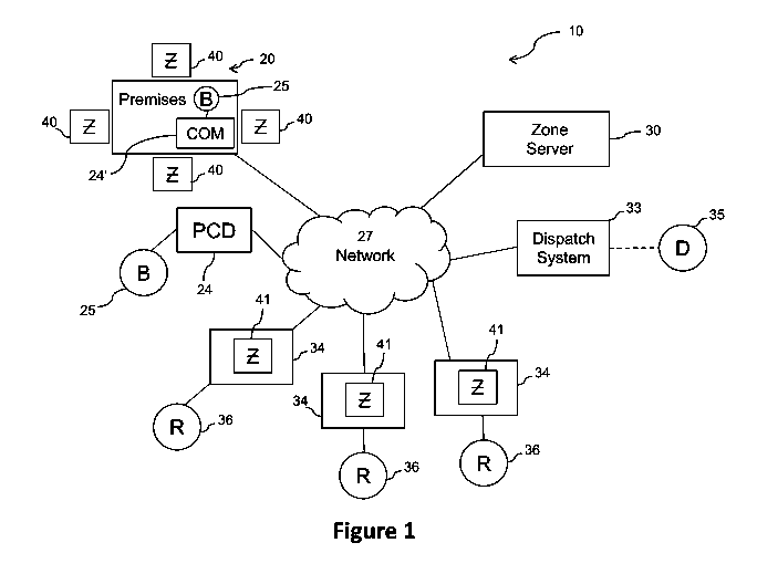
Figure 1 is a schematic view and blocked diagram form of
the various operative and structural features of the system of
the present invention.
Figures 2A-2D are schematic representations of structural
and operative features of a zone scheme utilized by end users
to interact with the system of Figure 1.
Figure 3A-3B are schematic representations of zone
displays associated with the zone scheme of Figures 2A-2B.
Figure 4A is a schematic representation of structural and
operative features of another zone scheme utilized by end
users to interact with the system of Figure 1.
Figures 4B-4C are schematic representations of zone
displays associated with the zone scheme of Figure 4A.
Figures 5A-5B depict a examples of satellite mapping
overlay display features associated with the respective zone
schemes.
Figure 6 depicts an example of threat level indicators
corresponding to respective zones, together with satellite
mapping overlay features.
Figure 7 depicts another example of a threat level
indicator associated with a particular zone, together with
architectural plan overlay features.
Figure 8 depicts an example of a threat level indicator
associated with a zone containing a portion of a default
evacuation route.
Figure 9 is a schematic representation of at least a
portion of the method of the present invention associated with
the system of Figure 1 and zone scheme(s) of Figures 2A
through 8.
Like reference numerals refer to like parts throughout
the several views of the drawings.
CA 02907569 2015-09-17
WO 2014/153321
PCT/US2014/030971
7
DETAILED DESCRIPTION OF THE PREFERRED EMBODIMENT
As represented in the accompanying Figures, the present
invention is directed to an improved emergency response system
and method 100 for use in responding to emergencies at
5 various premises 20 such as homes, businesses, neighborhoods,
campuses, etc. The system 10 utilizes designated directional
zones 45, which are individually and/or collectively oriented
with universal directional indicators 47. An emergency
dispatcher 35, or electronic equivalent, can reference the
10 designated directional zones 45 to relay important directional
information regarding a target location to first responders
36, regardless of whether additional premises-related
information is immediately available. In addition, the zones
45 can be displayed in a superimposed manner relative to
mapped features of the local premises, such as satellite
photos, site maps, architectural plans, etc. The system 10 is
further capable of assigning and displaying relative threat
levels 60 corresponding to the respective zones 45.
While many of the examples of the present disclosure
specifically pertain to school campus scenarios, the scope and
intent of the present invention also applies to a wide variety
of other types of premises, including but not limited to
office buildings, college campuses, hospitals, entertainment
venues, town squares, government facilities, laboratories,
manufacturing plants, distribution centers, storage and
logistical facilities, utility plants, etc. In
any case, the
improved emergency response system 10 and method 100
facilitate the conveying of more specific, immediate
information about a particular location 20 at issue.
Referring now to the accompanying drawings, Figure 1
depicts one preferred embodiment of a system in accordance
with the present invention, generally indicated as 10. The
system 10 may assume a variety of physical and logical
configurations, including a variety of
computing
processors/devices under a number of different operating
systems and network configurations.
CA 02907569 2015-09-17
WO 2014/153321
PCT/US2014/030971
8
The inventive system 10 and method 100 comprises hardware
and software run on one or more computer processors such as
personal computers, smart phones, servers and/or other type of
machines, preferably linked together through means including
but not limited to any number of the following: phone lines,
high speed cable, wireless technology, etc. The
aforementioned hardware and software of the present invention
can thus be utilized by remote users over a network, such as
the Internet.
Furthermore, certain aspects of the present
invention can comprise more traditional technologies such as
visual signage, posters, message boards, and the like, as well
as more modern electronic display technology including, but
not limited to, indoor and/or outdoor on-premises multimedia
displays.
As depicted in Figure 1, the local premises 20 will be
the subject of a particular scenario, such as an emergency or
other event which requires an emergency response. As
such,
certain observers of the event, represented as bystanders 25
("B") in Figure 1 will have the ability to communicate with a
dispatch system 33 and/or dispatcher 35 to relay information
about the event, including locational information. As
illustrated, such communication will typically be accomplished
via personal communication device 24 ("PCD") or other
competent local communication equipment 24' ("COM"), such as a
telephone, computer terminal, tablet pc, etc., over a
communication network 27.
More in particular, as discussed
further below, the bystander 25 will at a minimum identify and
communicate designated directional zone 45 information
associated with a zone display 40,41 ("Z").
In various embodiments, the zone displays 40,41 can
comprise an electronic display on a personal communication
device or other computing/communication device, visual
signage, posters, message boards, and the like, as well as
indoor and/or outdoor on-premises multimedia displays. In some
such embodiments, the zone displays are appropriately
displayed relative to an instant location of a correspondingly
CA 02907569 2015-09-17
WO 2014/153321
PCT/US2014/030971
9
referenced mobile device 24. In
other such embodiments, the
zone displays are fixedly positioned in strategic locations
about the premises 20, such as in the case of posters, signs,
and on-premises multimedia displays. It
is also within the
scope and intent of the present invention that other suitable
technologies capable of visual and/or audiovisual display can
also be utilized to implement the zone displays 40,41.
In at least one embodiment, a zone server 30 preferably
includes at least one computer processor and is structured to
have sufficient processing and/or storing capabilities to
manage the administration of relevant aspects of the system 10
in the intended manner, including, but not limited to, the
storage, processing, and manipulation of user input and
account information, such as various device data, settings,
premises data, user IDs, site specific information, and a
variety of zone-related data including maps, plans, threat
level status, etc. The
zone server 30 can also be
communicably connected with a dispatch system 33 to further
facilitate the interactive emergency response capabilities of
the system 10. The
zone server 30 is also communicably
connectable to the various personal communication devices 24,
on-premises communication equipment 24', and responder
interfaces 34 (discussed in more detail, below). As
shown,
the zone server 30 comprises a single location, however, it is
within the scope and intent of the present invention that the
zone server 30 can comprise multiple locations, as can the
various components thereof.
As noted, the system 10 also comprises a dispatch system
33 of the kind typically utilized by dispatchers 35 to
communicate with bystanders 25 and responders 36. For
instance, dispatch systems 33 will typically comprise
communication and computing features such as voice, data,
email, and other multimedia processing and communication
features, and can also comprise similar database functionality
to those of the zone server 30, mentioned above. By way
of
example, the dispatch system 33 can comprise one or more
CA 02907569 2015-09-17
WO 2014/153321
PCT/US2014/030971
servers as well as one or more databases. Accordingly, the
dispatch system 33 is communicably connected to the plurality
of user interfaces (e.g., personal communication devices 24,
on-premises communication equipment 24', and responder
5 interfaces 34) via the network 27 such that each of the user
interfaces may remotely and concurrently communicate with the
dispatch system 33.
Access to the various features, functionality, and data
associated with each zone 45, which are stored by the zone
10 server 30, may thus be accomplished via the various user
interfaces 24,24',34 as well as via the dispatch system 33.
In at least one embodiment, access to, and communication with,
the zone server 30, by the various user interfaces 24,24',34
and/or dispatch systems 33 is further facilitated by an
associated website. In
such an embodiment, the user
interfaces 24,24',34 and/or dispatch system 33 can each
utilize a web browser to access and communicate with the zone
server 30 via the website. In
at least one additional
embodiment, access to, and communication with, the zone server
30 is further facilitated by an associated mobile application.
In such an embodiment, the user interfaces 24,24',34 can
comprise wireless network devices capable of running the
mobile application to access and communicate with the zone
server 30. In
a still further embodiment, access to, and
communication with, the dispatch system 33 is also facilitated
by an associated mobile application executed by the user
interfaces 24,24',34.
As indicated above, one or more networks 27 connect the
zone server 30 and/or dispatch system 33 with each other and
with the various user interfaces 24,24',34. The
network 27
preferably comprises the Internet, although in other
embodiments, the network 27 can also comprise a service
provider private network, virtual private network, local area
network, ad hoc network, or other type of network. The user
interfaces 24,24',34 can accordingly be structured to
communicate with the network 27 under various protocols and
CA 02907569 2015-09-17
WO 2014/153321
PCT/US2014/030971
11
wired or wireless technologies, such as, but not limited to,
the Internet, cellular, satellite, WIFI, WIMAX, WLAN, WAN,
LAN, WIFI hotspot, Intranet, ZIGBEE, BLUETOOTH, etc.
With continued reference to Figure 1, and as indicated
above, the system 10 includes at least one but more
practically a plurality of responder interfaces 34, utilized
by the emergency responders or other appropriate personnel 36
involved in facilitating the response to a given situation.
The responder interfaces 34 each preferably comprise at least
one computer processor and a communication capability. By way
of example, the responder interfaces 34 can comprise a cell
phone, a personal computer, a laptop or notebook computer, a
personal digital assistant, smart phone, tablet, wearable
electronic device, or other handheld device, any of which may
include associated accessories such as microphones, speakers,
headphones, visual displays, keypads, etc. Accordingly, the
responder interfaces 34 are each communicably connected to the
network 27, as depicted in Figure 1.
In at least some embodiments, the responder interfaces 34
are structured for presenting a variety of visual, audio,
and/or audiovisual content to the responders 36, and for
receiving similar input from the responders 36 and/or the
responders' environment. As
used herein, the verb "to
present" (i.e., "present," "presenting," "presented," etc.)
means to display, sound, play, and/or otherwise reproduce
visual, audio, and/or audiovisual content, such as, but not
limited to, text, pictures, graphics, video, music, sounds,
voice, vibrations, etc. It
is thus within the scope and
intent of the present invention that the visual presentation
of the interactive content can be accomplished via one or more
display components of the user interfaces 24,24',34; whereas
any audio presentation of audio content can be accomplished
via one or more speakers or other suitable components
associated with the user interfaces 24,24',34.
Turning now to Figure 2A, a schematic illustration of a
zone scheme utilized by end users to interact with the system
CA 02907569 2015-09-17
WO 2014/153321
PCT/US2014/030971
12
of Figure 1 is depicted. As
noted above, the physical
embodiment of the zone displays 40,41 can take the form of
traditional hardcopy, such as signs, posters, maps, etc., as
well as modern electronic displays, such as electronic
5 billboards, computer screens, mobile communication device
displays, etc. The system 10 utilizes designated directional
zones 45, which are individually and/or collectively oriented
with universal directional indicators 47. An emergency
dispatcher 35, or electronic equivalent, can reference the
10 designated directional zones 45 to relay important directional
information regarding a target location 20 to first responders
36, regardless of whether additional premises-related
information is immediately available.
In the embodiment of Figure 2A, the layout of a premises
20 is represented by four zones 45 numbered "1" through "4" as
displayed in connection with the number displays 43. As such,
in this embodiment, the relative orientation of the number
displays 43 serve as universal directional indicators 47. For
instance, when the number "2" associated with zone 2 is viewed
as showing immediately to the right of the number "1"
associated with zone 1, a direction of true North is indicated
accordingly. Likewise, as seen in Figure 2B, when the number
"3" associated with zone 3 is viewed as showing immediately to
the right of the number "2" associated with zone 2, a
direction of true East is indicated. Thus,
consistent with
universal directional indicators 47, the orientation of the
zone display 40, 41 is appropriately rotated according to a
particular corresponding reference location about the actual
premises 20. For
instance, when displayed in the form of
physical signage 40, an observer facing the Western entrance
area of a premises 20 might see a zone display 40,41 depicted
in the manner of Figure 2B (as he/she will be facing East).
Similarly, when displayed via a mobile device screen, a user
who has entered the premises might view a zone display 40,41
shown in the manner of Figure 2A, as they move northward
towards a corresponding intended direction or zone 45. By way
CA 02907569 2015-09-17
WO 2014/153321
PCT/US2014/030971
13
of further example, in such an embodiment, additional screen
displays may be utilized in a complimentary manner, such as
compass points, position prompts, directional pointers, etc.
Furthermore, as seen in Figures 2A-2B, one preferred
arrangement for the zones 45 involves implementation of a
quadrant scheme, wherein each zone display 40,41 is divided
into four quadrants such that four primary zones 45 each
generally comprise about twenty five percent of the area of
the zone display 40,41. As discussed in further detail,
below, the quadrants can further be divided into "microzones"
49, 49', also into corresponding quadrants, if desired. While
this is not the only appropriate manner in which to
organize/arrange the various zones 45, it is shown as a
preferred embodiment that can be implemented in a relatively
straightforward manner to carry out the objectives of the
present invention.
With reference to Figures 2C-2D, the zones 45 can further
be associated with different color codes 46. The color codes
46 serve to differentiate the zones and, further, may serve to
cooperatively identify at least one aspect of the universal
directional indicators 47. For example, in this embodiment,
when the color associated with zone 2 is viewed as showing
immediately to the right of the color associated with zone 1,
a direction of true north is indicated accordingly. As one
example, zone 1 might be color coded green, zone 2 blue, zone
3 orange, and zone 4 yellow. As such, in this embodiment, the
relative orientation of the number displays 43 and the
relative orientation of the color codes 46, both respectively
and collectively, serve as universal directional indicators
47.
In accordance with the above examples, it is contemplated
that in at least some embodiments, the zone scheme can be
systematically implemented in such a manner that even a child
will be able to relay critical emergency information to a
dispatcher 35 or other responder 36. By way of example, only,
the below dialogue provides a basic remote telephone call
CA 02907569 2015-09-17
WO 2014/153321
PCT/US2014/030971
14
scenario in the setting of an elementary school emergency, in
which referencing the zones 45 can facilitate an emergency
response:
Caller 25:
"Help! There is a fire at the school!"
Dispatcher 35:
"Where is the fire located?"
Caller 25:
"In Ms. Childers' classroom."
Dispatcher 35:
"What zone is Ms. Childers' classroom in?"
Caller 25:
"Zone 1." (phone disconnects...)
Dispatcher 35:
"Attention all units, fire at Coral Reef Elementary
School.
Multiple calls advising that fire is
located in Ms. Childers' class in Zone 1.
Fire in
Zone 1."
Responder 36:
"Roger that. Unit seven heading to Coral Reef
Elementary School, Zone 1."
By way of further example, reference is made to Figures
3A-3B which represent additional, dynamic display aspects of
zone displays 40, 41 associated with the zone scheme of
Figures 2A-2D. As seen in Figure 3A, a particular color code
46 is enabled for "zone 1" to convey additional information
relative to the other zones 45. For example, the status of a
particular zone 45 might be emphasized relative to the others
by such use of the color codes 46. As
depicted, the color
codes of the other three zones are not active. Accordingly,
in one scenario, such a scheme might indicate that "zone 1"
should be avoided while all other zones are still safe to
occupy. In
the embodiment of Figure 3B, color codes 46 are
activated for three of the four zones 45. It
is, of course,
within the scope and intent of the present invention that
other combinations of color codes 46 and/or number displays 43
CA 02907569 2015-09-17
WO 2014/153321
PCT/US2014/030971
can be activated in a similar manner to convey appropriate
information.
Furthermore, with additional reference to the dynamic
display aspects of Figures 3A-3B, hardcopy zone displays 40
5 can be posted and updated manually, such as when a posted
display 40 is printed accordingly in real time, or selected
from a stack of pre-printed displays 40, etc. In the case of
electronic zone displays 40,41, the presentation of a
particular display can simply be electronically updated in
10 real time as circumstances dictate. Moreover, as also
represented in Figures 3A-3B, additional information can be
conveyed by the zone displays 40, 41, via use of symbols,
text, graphics, etc. As depicted in Figures 3A-3B, two such
examples include a zone status summary field 48 and a premises
15 identifier field 48'. As one a basic example, the zone status
summary field 48 of Fig. 3A indicates the active status of
"zone 1." Likewise, the zone status summary field 48 of Fig.
3B indicates the active status of "zone 1," "zone 2," and
"zone 3." It is further contemplated that a variety of other
information can also be conveyed by the zone status summary
field 48. As also depicted, the premises field 48' indicates
the name of the particular premises 20 at issue, such a
business name, although in other embodiments, the premises
identifier field 48' can indicate the name of a hospital,
school campus, individual home, neighborhood, etc., as
appropriate.
In view of the foregoing examples, it should be noted
that it is within the scope and intent of the present
invention that any number, size, shape and/or color of zones
45, as well as a variety of symbols associated therewith, may
be utilized to achieve a desired correlation with directional
indicators and to convey other appropriate information
associated with a given zone scheme.
Accordingly, with reference to Figures 4A-4C, various
"microzones" 49, 49' are depicted which function as zones 49,
49' within other zones 45. As schematically shown in Figures
CA 02907569 2015-09-17
WO 2014/153321
PCT/US2014/030971
16
4A-4B, the microzones 49 are represented by letter displays 50
("A" through "D"). With further reference to the example of
Figure 4B, microzone "A" pertains to a main office area;
whereas microzone "C" represents a cafeteria area. In
this
manner, orderly reference to microzones 49, 49' can be made in
emergency response efforts, such as "zone 1A" to indicate
microzone "A" in "zone 1."
While Figure 4B schematically represents a publicly
accessible zone display 40, 41, Figure 4C depicts an
embodiment of a more selectively accessible display, such as
that available to law enforcement but not to the general
public. For
instance, by electronically accessing the
publicly available data in connection with an emergency
response scenario, law enforcement or other select responders
can set up customized, selectively accessible zone displays
41' for their own internal communication and response
purposes. As shown in Figure 4C, microzones 49, 49' can
accordingly be referenced in connection with efforts to
isolate and contain a threat, such as in this example an
office lounge of "zone 1, microzone A, submicrozone A" (with
shorthand reference "01:A:A") and/or a principal's office of
"zone 1, microzone A, submicrozone D" (with shorthand
reference "01:A:D").
In view of the foregoing examples, it is also is within
the scope and intent of the present invention that the
aforementioned zone displays 40, 41, 41' and related system 10
features could be integrated with a variety of existing
databases and information technologies, including, but not
limited to GOOGLE maps, MICROSOFT MAPS, APPLE maps, SKYPE,
GPS, Department of Defense databases, local police and/or fire
department databases, existing emergency dispatch systems 33,
etc. Furthermore, various aspects of the system 10 could be
integrated with premises monitoring systems, security systems,
and the like, such as ADT systems, DEVCON systems, BRINKS
systems, VIVINT systems, etc.
Turning now to additional interactive multimedia features
CA 02907569 2015-09-17
WO 2014/153321
PCT/US2014/030971
17
of the system 10, at least some of which could interact,
integrate, or otherwise interface with the aforementioned
technologies of the preceding paragraph, Figures 5A-5B depict
examples of mapping overlay display features 51 associated
with the respective zone schemes. For instance, Figure 5
depicts a satellite image overlay 51 of a school campus which
corresponds to four designated zones 45 ("zones 1-4"). In
this way, the mapping overlay display features 51 permit
display of zones 45 and zone-related information in a
superimposed manner relative to mapped features of the local
premises, such as satellite photos, street maps, site maps,
architectural plans, etc., for the general area, specific
premises 20, and/or particular area within the premises 20.
In some embodiments, this display can be dynamically adjusted,
in relatively short order, if not immediately in real time (or
upon request).
Another useful feature of the system 10 is depicted in
Figure 6 which presents an example of threat level indicators
55 corresponding to respective zones 45. The
users, such as
first responders 36, dispatchers 35, or automated aspects of
the dispatch system 33 can evaluate pertinent conditions and
appropriately determine a corresponding threat level
associated with a given zone 45.
Once a threat level is
determined, the threat level can be displayed via the
corresponding threat level indicator 55. By way
of example,
threat level indicators 55 can assume the relative
presentations of a heat index, such that "warm zones" are
identified with moderate hazards, "hot zones" are identified
with imminent threats, etc. Furthermore, a threat containment
line 56 can also be calculated and displayed based on
pertinent conditions. In
the example shown, the threat
containment line 56 is displayed in a manner that separates
the "hot zone" in "zone 1" from the "warm zone" areas of
"zones 2-4." Further still, the system 10 is capable of
assigning and displaying relative threat level indicators 55
in dynamic fashion as the situation develops, such as in real
CA 02907569 2015-09-17
WO 2014/153321
PCT/US2014/030971
18
time.
Likewise, the system 10 is capable of adjusting the
position and other parameters of the threat containment line
56 in real time, as circumstances dictate.
By way of further example, Figure 7 depicts another
instance of a threat level indicator 55 associated with a
particular zone 45, together with architectural plan or
"blueprint" image overlay 51 features. In
the foregoing
scenarios, the dispatcher 35 could direct first responders 36
towards the direction of the threat (hot zone), while
bystanders 25 can take measures to move away from the threat
(hot zone).
As yet another example, Figure 8 depicts an example of a
threat level indicator associated with a zone 45 which
contains a portion of a default evacuation route 57.
Generally, pre-designated evacuation routes 57 are typically
designed to provide the safest path of escape; however, such
routes 57 by their nature tend to limit evacuees 25 to one
single path of travel.
Thus, in cases of extreme emergency,
such as when the pre-established evacuation route 57 becomes
blocked, destroyed, or otherwise dangerous to follow, the
system 10 of the present invention can provide evacuees 25
with alternative pathways and/or warnings to not enter a
hazardous zone. As one example of a warning, a threat level
indicator 55 can be implemented to alert evacuees 25 to avoid
entering the pre-established evacuation route 57 (in this case
represented a shading of the zone 45,
"zone 1") and to seek
alternatives.
In accordance with the above-described system 10, the
present invention also contemplates methods of utilizing the
innovative system 10 accordingly. By way of example, Figure 9
depicts a schematic representation of at least a portion of a
corresponding method 100 associated with use of the system 10
of Figure 1 and the zone scheme(s) of Figures 2A through 8.
With primary reference now to Figure 9, the method 100
associated with the system 10 begins at Block 102 wherein the
plurality of zones 45 is defined, with each zone typically
CA 02907569 2015-09-17
WO 2014/153321
PCT/US2014/030971
19
corresponding to a different portion of the local premises 20.
Next, the above-described universal directional
indicators 47 are defined, as at Block 104. Once defined, the
universal directional indicators 47 are appropriately
associated with corresponding zones 45 (Block 106), such as in
the various zone schemes described, above.
Accordingly, the designated directional zones 45 and the
universal directional indicators 47 are then presented to
users, as at Block 108, for use in facilitating an emergency
response to the local premises 20. For example, an emergency
dispatcher 35, or electronic equivalent, can reference the
designated directional zones 45 to relay important directional
information regarding a target location to first responders
36, regardless of whether additional premises-related
information is immediately available. As
another example, a
bystander 25 can use such information to relay important
directional information to a dispatcher 35.
As noted above, additional features can be incorporated
into the presentation of zones 45, including the
aforementioned "microzones" 49, 49', mapping overlay display
features 51, threat level indicators 55, etc.
Since many modifications, variations and changes in
detail can be made to the described preferred embodiment of
the invention, it is intended that all matters in the
foregoing description and shown in the accompanying drawings
be interpreted as illustrative and not in a limiting sense.
Thus, the scope of the invention should be determined by the
appended claims and their legal equivalents.
Now that the invention has been described,