Note: Descriptions are shown in the official language in which they were submitted.
81792610
- 1 -
LOCAL LAYER GEOMETRY ENGINE WITH WORK ZONE GENERATED FROM BUFFER
DEFINED RELATIVE TO A WELLBORE TRAJECTORY
Cross-Reference to Related Applications
[0001] This application claims the filing benefit of U.S. Provisional Patent
Application
Serial No. 62/076,219 filed on November 6, 2014.
Background
[0002] Formation modeling is used to model the locations of the boundaries
between
subsurface layers and layers properties in a subsurface formation in close
proximity to a
wellbore. Formation modeling may be an interactive process whereby a user
interacts with a
computer model, e.g., through a graphical user interface, to select the
locations and properties
of subsurface layers in a subsurface formation.
[0003] Formation modeling is generally based upon sensor data collected from
one or
more types of sensors that are placed in a wellbore either during drilling of
the wellbore or after
drilling, and as such, the data is generally focused in an area in close
proximity to the wellbore
itself. While some sensors are capable of collecting data that may extend
several feet or
meters from a wellbore, other sensors collect much shallower data, e.g.,
within 6 to 24 inches
or less around a wellbore. Regardless, the distances within which all such
sensors collect data
are orders of magnitude smaller than the size of a subsurface formation or
even the lengths of
the wellbores from which the data is collected, as wellbores may extend
thousands of feet or
meters below the surface.
[0004] Generally, when performing formation modeling, a user is presented with
a two
or three dimensional view of the wellbore as well as additional depictions of
relevant sensor
data, and the user interprets that data and selects locations around the
wellbore to define
points and/or line segments representing boundaries between
Date Recue/Date Received 2022-04-22
CA 02911107 2015-11-04
- 2
adjacent subsurface layers. A work zone may be defined around a wellbore to
enable a
user to interact with a small region around the wellbore. A work zone is
generally
rectangular in shape, however, and it has been found that particularly for
modeling from
sensor data that is shallow in nature, formation modeling is complicated by
the use of
such a rectangular work zone because the work zone may necessarily include
regions
that are spaced beyond the range of the sensors used to collect the sensor
data, and
further, because artifacts may be introduced as a result of automated efforts
to define
the boundaries between adjacent subsurface layers.
Summary
[0005] Consistent with one aspect of the invention, a method may model a
subsurface formation using sensor data collected along a wellbore extending
through
the subsurface formation by determining a buffer along a length of the
wellbore, the
buffer defined by a closed curve surrounding the length of the wellbore,
generating a
work zone from the determined buffer for display on a computer display,
visualizing a
region of the subsurface formation along the length of the wellbore by
populating the
work zone using sensor data collected along the length of the wellbore,
visualizing
boundaries between a plurality of layers in the region of the subsurface
formation in the
work zone, and building a computer model of the region of the subsurface
formation
based upon positions of the boundaries visualized in the work zone.
[0006] In some embodiments, the closed curve comprises a polygon, and the
work zone comprises a polygonal work zone. In addition, in some embodiments,
determining the buffer includes determining the buffer to extend a
predetermined
distance generally transverse to a trajectory of the wellbore, while in some
embodiments, the predetermined distance corresponds to a range of a sensor
used to
collect the sensor data. Further, in some embodiments, the polygonal work zone
is
non-rectangular.
[0007] In addition, in some embodiments, visualizing the boundaries includes
visualizing a first boundary between first and second layers among the
plurality of
layers. In some embodiments, the first boundary is defined by a plurality of
points, and
CA 02911107 2015-11-04
- 3
visualizing the first boundary inclUdes visualizing the plurality of points
defining the first
boundary in the work zone. In some embodiments, visualizing the first boundary
further
includes visualizing at least one edge extending between at least one pair of
the
plurality of points, and in some embodiments, the first and second layers are
respectively defined by first and second polygons partitioned from the polygon
for the
work zone, and the plurality of points in the first boundary are shared by the
first and
second polygons. Some embodiments further include updating the first and
second
polygons defining the first and second layers in response to user input that
moves a first
point among the plurality of points, and some embodiments further include
updating the
first and second polygons defining the first and second layers in response to
user input
that deletes a first point among the plurality of points. In some embodiments,
updating
the first and second polygons in response to user input that deletes the first
point
includes merging the first and second polygons and thereby merging the first
and
second layers.
[0008] In addition, some embodiments include creating a new boundary in
response to user input, and in some embodiments, the new boundary splits the
second
polygon defining the second layer, and creating the new boundary further
includes
resizing the second polygon and splitting a third polygon from the second
polygon to
define a third layer among the plurality of layers. In some embodiments, at
least one
edge of the first polygon extends along an edge of the polygonal work zone.
[0009] Some embodiments further include automatically generating the
boundaries between the plurality of layers based upon the sensor data
collected along
the length of the wellbore. In addition, in some embodiments, the computer
model
includes one or more attributes, at least one of the one or more attributes is
a layer
attribute, a boundary attribute, a segment attribute or a point attribute,
each of the
plurality of layers includes a value for each of the one or more attributes,
automatically
generating the boundaries includes automatically assigning the value for each
of the
one or more attributes to each of the plurality of layers based upon the
sensor data
collected along the length of the wellbore, populating the work zone using the
sensor
data collected along the length of the wellbore includes visualizing the
plurality of layers
81792610
- 4 -
using colors, shades or patterns correlated to the assigned values of at least
one of the one or
more attributes, and the values of the one or more attributes assigned to each
of the plurality of
layers are user editable. Further, in some embodiments, generating the work
zone, visualizing
the region of the subsurface formation and visualizing the boundaries are
performed by a local
layer geometry engine.
[0010] In addition, some embodiments include an apparatus with at least one
processing unit and program code configured upon execution by the at least one
processing
unit to perform any of the aforementioned methods. Some embodiments also
include a
program product including a computer readable medium and program code stored
on the
computer readable medium and configured upon execution by at least one
processing unit to
perform any of the aforementioned methods.
[0010a] Some embodiments disclosed herein provide a computer-implemented
method of modeling a subsurface formation using sensor data collected along a
wellbore
extending through the subsurface formation, the method comprising: determining
a buffer
along a length of the wellbore, the buffer defined by a closed curve
surrounding the length of
the wellbore; generating a work zone from the determined buffer for display on
a computer
display; visualizing a region of the subsurface formation along the length of
the wellbore by
populating the work zone using the sensor data collected along the length of
the wellbore;
visualizing boundaries between a plurality of layers in the region of the
subsurface formation in
the work zone; and building a computer model of the region of the subsurface
formation based
upon positions of the boundaries visualized in the work zone.
[0010b] Some embodiments disclosed herein provide an apparatus, comprising: at
least one processing unit; and program code configured upon execution by the
at least one
processing unit to model a subsurface formation using sensor data collected
along a
wellbore extending through the subsurface formation by: determining a buffer
along a
length of the wellbore, the buffer defined by a closed curve surrounding the
length of the
wellbore; generating a work zone from the determined buffer for display on a
computer
display; visualizing a region of the subsurface formation along the length of
the wellbore by
populating the work zone using the sensor data collected along the length of
the wellbore;
Date Recue/Date Received 2022-04-22
81792610
- 4a -
visualizing boundaries between a plurality of layers in the region of the
subsurface
formation in the work zone; and building a computer model of the region of the
subsurface
formation based upon positions of the boundaries visualized in the work zone.
[0010c] Some embodiments disclosed herein provide a program product,
comprising: a
computer readable medium; and program code stored on the computer readable
medium
and configured upon execution by at least one processing unit to model a
subsurface
formation using sensor data collected along a wellbore extending through the
subsurface
formation by: determining a buffer along a length of the wellbore, the buffer
defined by a
closed curve surrounding the length of the wellbore; generating a work zone
from the
determined buffer for display on a computer display; visualizing a region of
the subsurface
formation along the length of the wellbore by populating the work zone using
the sensor
data collected along the length of the wellbore; visualizing boundaries
between a plurality
of layers in the region of the subsurface formation in the work zone; and
building a
computer model of the region of the subsurface formation based upon positions
of the
boundaries visualized in the work zone.
[0011] These and other advantages and features, which characterize the
invention,
are set forth in the claims annexed hereto and forming a further part hereof.
However, for a
better understanding of the invention, and of the advantages and objectives
attained through
its use, reference should be made to the Drawings, and to the accompanying
descriptive
matter, in which there is described example embodiments of the invention. This
summary is
merely provided to introduce a selection of concepts that are further
described below in the
detailed description, and is not intended to identify key or essential
features of the claimed
subject matter, nor is it intended to be used as an aid in limiting the scope
of the claimed
subject matter.
Brief Description of the Drawings
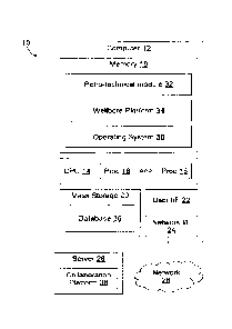
[0012] FIGURE 1 is a block diagram of an example hardware and software
environment for a data processing system in accordance with implementation of
various
technologies and techniques described herein.
Date Recue/Date Received 2022-04-22
81792610
- 4b -
[0013] FIGURES 2A-2D illustrate simplified, schematic views of an oilfield
having
subterranean formations containing reservoirs therein in accordance with
implementations of
various technologies and techniques described herein.
Date Recue/Date Received 2022-04-22
CA 02911107 2015-11-04
- 5
[0014] FIGURE 3 illustrates a schematic view, partially in cross section of an
oilfield having a plurality of data acquisition tools positioned at various
locations along
the oilfield for collecting data from the subterranean formations in
accordance with
implementations of various technologies and techniques described herein.
[0015] FIGURE 4 illustrates a production system for performing one or more
oilfield operations in accordance with implementations of various technologies
and
techniques described herein.
[0016] FIGURES 5 and 6 respectively illustrate rectangular and polygonal work
zones that may be used in global and local layer modeling, with Fig. 6
illustrating a non-
rectangular polygonal work zone.
[0017] FIGURES 7 and 8 illustrate automatic layer generation performed within
a work zone, with Fig. 8 illustrating automatic layer generation when using a
buffer in
accordance with implementations of various technologies and techniques
described
herein.
[0018] FIGURES 9A-9C illustrate example buffer polygons at different distances
or radii around an example borehole trajectory in accordance with
implementations of
various technologies and techniques described herein.
[0019] FIGURE 10 illustrates an example visualization of a polygonal work zone
corresponding to a portion of the subsurface formation represented in Fig. 8.
[0020] FIGURES 11 and 12 respectively illustrate local and global layer
modeling techniques, with Fig. 11 further illustrating the sharing of points
by multiple
polygons, and with Fig. 12 illustrating a non-polygonal approach in which
polygons do
not share points.
[0021] FIGURES 13A and 13B illustrate the addition of a new subsurface layer
and the splitting of a polygonal work zone in accordance with implementations
of
various technologies and techniques described herein.
CA 02911107 2015-11-04
- 6 -
[0022] FIGURES 14A and 14B illustrate the movement of a point and the
resulting modification of multiple polygons in response thereto in accordance
with
implementations of various technologies and techniques described herein.
[0023] FIGURE 14C illustrates the deletion of a segment [B,A1 from Fig. 14B
and the resulting merging of multiple polygons in response thereto in
accordance with
implementations of various technologies and techniques described herein.
[0024] FIGURES 15 and 16 illustrate the creation of multiple polygonal work
zones at different positions along a wellbore, with Fig. 15 additionally
illustrating multiple
subsurface layers defined within the multiple polygonal work zones.
[0025] FIGURE 17 illustrates an example sequence of operations for a
formation modeling routine in accordance with implementations of various
technologies
and techniques described herein.
Detailed Description
[0026] The embodiments disclosed herein provide a method, apparatus, and
program product that utilize a buffer defined relative to a wellbore
trajectory to generate
a work zone around a wellbore for use in connection with formation modeling.
In some
embodiments, for example, a closed curve such as a non-rectangular, polygonal
work
zone may be defined around a wellbore based upon a buffer that extends
generally
transverse to the trajectory of a length of a wellbore a predetermined
distance. In
addition, boundaries may be defined in a work zone to effectively split the
work zone
into multiple closed curves or polygons in response to user editing, e.g., to
create one or
more subsurface layers in the work zone. In such instances, points defining a
subsurface layer may be shared by adjacent layers such that editing of such
points will
affect each of the layers sharing such points.
[0027] Prior to a discussion of formation modeling utilizing such a work zone,
however, a discussion of an example hardware and software embodiment, as well
as of
oilfield operations in general, will be provided.
CA 02911107 2015-11-04
- 7 -
Hardware and Software Environment
[0028] Turning now to the drawings, wherein like numbers denote like parts
throughout the several views, Fig. 1 illustrates an example data processing
system 10 in
which the various technologies and techniques described herein may be
implemented.
System 10 is illustrated as including one or more computers 12, e.g., client
computers,
each including a central processing unit (CPU) 14 including at least one
hardware-
based processor or processing core 16. CPU 14 is coupled to a memory 18, which
may
represent the random access memory (RAM) devices comprising the main storage
of a
computer 12, as well as any supplemental levels of memory, e.g., cache
memories,
non-volatile or backup memories (e.g., programmable or flash memories), read-
only
memories, etc. In addition, memory 18 may be considered to include memory
storage
physically located elsewhere in a computer 12, e.g., any cache memory in a
microprocessor or processing core, as well as any storage capacity used as a
virtual
memory, e.g., as stored on a mass storage device 20 or on another computer
coupled
to a computer 12.
[0029] Each computer 12 also generally receives a number of inputs and
outputs for communicating information externally. For interface with a user or
operator,
a computer 12 generally includes a user interface 22 incorporating one or more
user
input/output devices, e.g., a keyboard, a pointing device, a display, a
printer, etc.
Otherwise, user input may be received, e.g., over a network interface 24
coupled to a
network 26, from one or more external computers, e.g., one or more servers 28
or other
computers 12. A computer 12 also may be in communication with one or more mass
storage devices 20, which may be, for example, internal hard disk storage
devices,
external hard disk storage devices, storage area network devices, etc.
[0030] A computer 12 generally operates under the control of an operating
system 30 and executes or otherwise relies upon various computer software
applications, components, programs, objects, modules, data structures, etc.
For
example, a petro-technical module or component 32 executing within a wellbore
platform 34 may be used to access, process, generate, modify or otherwise
utilize
petro-technical data, e.g., as stored locally in a database 36 and/or
accessible remotely
81792610
- 8 -
from a collaboration platform 38. Collaboration platform 38 may be implemented
using multiple
servers 28 in some implementations, and it will be appreciated that each
server 28 may
incorporate a CPU, memory, and other hardware components similar to a computer
12.
[0031] In one non-limiting embodiment, for example, petro-technical module 32
may
be implemented as a 3D petrophysics (3DP) module, wellbore platform 34 may
implemented
as the Techlog software platform, while collaboration platform 38 may be
implemented as the
STUDIO E&P KNOWLEDGE ENVIRONMENTTm platform, all of which are available from
Schlumberger Ltd. and its affiliates. It will be appreciated, however, that
the techniques
discussed herein may be utilized in connection with other platforms and
environments, so the
invention is not limited to the particular software platforms and environments
discussed herein.
[0032] In general, the routines executed to implement the embodiments
disclosed
herein, whether implemented as part of an operating system or a specific
application,
component, program, object, module or sequence of instructions, or even a
subset thereof, will
be referred to herein as "computer program code," or simply "program code."
Program code
generally comprises one or more instructions that are resident at various
times in various
memory and storage devices in a computer, and that, when read and executed by
one or more
hardware-based processing units in a computer (e.g., microprocessors,
processing cores, or
other hardware-based circuit logic), cause that computer to perform the steps
embodying
desired functionality. Moreover, while embodiments have and hereinafter will
be described in
the context of fully functioning computers and computer systems, those skilled
in the art will
appreciate that the various embodiments are capable of being distributed as a
program product
in a variety of forms, and that the invention applies equally regardless of
the particular type of
computer readable media used to actually carry out the distribution.
[0033] Such computer readable media may include computer readable storage
media
and communication media. Computer readable storage media is non-transitory in
nature, and
may include volatile and non-volatile, and removable and non-removable
Date Recue/Date Received 2022-04-22
CA 02911107 2015-11-04
- 9 -
media implemented in any'method or technology for storage of information, such
as
computer-readable instructions, data structures, program modules or other
data.
Computer readable storage media may further include RAM, ROM, erasable
programmable read-only memory (EPROM), electrically erasable programmable read-
only memory (EEPROM), flash memory or other solid state memory technology, CD-
ROM, DVD, or other optical storage, magnetic cassettes, magnetic tape,
magnetic disk
storage or other magnetic storage devices, or any other medium that can be
used to
store the desired information and which can be accessed by computer 10.
Communication media may embody computer readable instructions, data structures
or
other program modules. By way of example, and not limitation, communication
media
may include wired media such as a wired network or direct-wired connection,
and
wireless media such as acoustic, RF, infrared and other wireless media.
Combinations
of any of the above may also be included within the scope of computer readable
media.
[0034] Various program code described hereinafter may be identified based
upon the application within which it is implemented in a specific embodiment
of the
invention. However, it should be appreciated that any particular program
nomenclature
that follows is used merely for convenience, and thus the invention should not
be limited
to use solely in any specific application identified and/or implied by such
nomenclature.
Furthermore, given the endless number of manners in which computer programs
may
be organized into routines, procedures, methods, modules, objects, and the
like, as well
as the various manners in which program functionality may be allocated among
various
software layers that are resident within a typical computer (e.g., operating
systems,
libraries, API's, applications, applets, etc.), it should be appreciated that
the invention is
not limited to the specific organization and allocation of program
functionality described
herein.
[0035] Furthermore, it will be appreciated by those of ordinary skill in the
art
having the benefit of the instant disclosure that the various operations
described herein
that may be performed by any program code, or performed in any routines,
workflows,
or the like, may be combined, split, reordered, omitted, and/or supplemented
with other
CA 02911107 2015-11-04
- 10 -
techniques known in the art, and 'therefore, the invention is not limited to
the particular
sequences of operations described herein.
[0036] Those skilled in the art will recognize that the example environment
illustrated in Fig. 1 is not intended to limit the invention. Indeed, those
skilled in the art
will recognize that other alternative hardware and/or software environments
may be
used without departing from the scope of the invention.
Oilfield Operations
[0037] Figs. 2A-2D illustrate simplified, schematic views of an oilfield 100
having subterranean formation 102 containing reservoir 104 therein in
accordance with
implementations of various technologies and techniques described herein. Fig.
2A
illustrates a survey operation being performed by a survey tool, such as
seismic truck
106.1, to measure properties of the subterranean formation. The survey
operation is a
seismic survey operation for producing sound vibrations. In Fig. 2A, one such
sound
vibration, sound vibration 112 generated by source 110, reflects off horizons
114 in
earth formation 116. A set of sound vibrations is received by sensors, such as
geophone-receivers 118, situated on the earth's surface. The data received 120
is
provided as input data to a computer 122.1 of a seismic truck 106.1, and
responsive to
the input data, computer 122.1 generates seismic data output 124. This seismic
data
output may be stored, transmitted or further processed as desired, for
example, by data
reduction.
[0038] Fig. 2B illustrates a drilling operation being performed by drilling
tools
106.2 suspended by rig 128 and advanced into subterranean formations 102 to
form
wellbore 136. Mud pit 130 is used to draw drilling mud into the drilling tools
via flow line
132 for circulating drilling mud down through the drilling tools, then up
wellbore 136 and
back to the surface. The drilling mud may be filtered and returned to the mud
pit. A
circulating system may be used for storing, controlling, or filtering the
flowing drilling
muds. The drilling tools are advanced into subterranean formations 102 to
reach
reservoir 104. Each well may target one or more reservoirs. The drilling tools
are
CA 02911107 2015-11-04
- 11 -
adapted for measuring doWnhole'properties using logging while drilling tools.
The
logging while drilling tools may also be adapted for taking core sample 133 as
shown.
[0039] Computer facilities may be positioned at various locations about the
oilfield 100 (e.g., the surface unit 134) and/or at remote locations. Surface
unit 134 may
be used to communicate with the drilling tools and/or offsite operations, as
well as with
other surface or downhole sensors. Surface unit 134 is capable of
communicating with
the drilling tools to send commands to the drilling tools, and to receive data
therefrom.
Surface unit 134 may also collect data generated during the drilling operation
and
produces data output 135, which may then be stored or transmitted.
[0040] Sensors (S), such as gauges, may be positioned about oilfield 100 to
collect data relating to various oilfield operations as described previously.
As shown,
sensor (S) is positioned in one or more locations in the drilling tools and/or
at rig 128 to
measure drilling parameters, such as weight on bit, torque on bit, pressures,
temperatures, flow rates, compositions, rotary speed, and/or other parameters
of the
field operation. Sensors (S) may also be positioned in one or more locations
in the
circulating system.
[0041] Drilling tools 106.2 may include a bottom hole assembly (BHA) (not
shown), generally referenced, near the drill bit (e.g., within several drill
collar lengths
from the drill bit). The bottom hole assembly includes capabilities for
measuring,
processing, and storing information, as well as communicating with surface
unit 134.
The bottom hole assembly further includes drill collars for performing various
other
measurement functions.
[0042] The bottom hole assembly may include a communication subassembly
that communicates with surface unit 134. The communication subassembly is
adapted
to send signals to and receive signals from the surface using a communications
channel
such as mud pulse telemetry, electro-magnetic telemetry, or wired drill pipe
communications. The communication subassembly may include, for example, a
transmitter that generates a signal, such as an acoustic or electromagnetic
signal, which
is representative of the measured drilling parameters. It will be appreciated
by one of
CA 02911107 2015-11-04
- 12 -
skill in the art that a variety of telemetry systems may be employed, such as
wired drill
pipe, electromagnetic or other known telemetry systems.
[0043] Generally, the wellbore is drilled according to a drilling plan that is
established prior to drilling. The drilling plan sets forth equipment,
pressures,
trajectories and/or other parameters that define the drilling process for the
wellsite. The
drilling operation may then be performed according to the drilling plan.
However, as
information is gathered, the drilling operation may need to deviate from the
drilling plan.
Additionally, as drilling or other operations are performed, the subsurface
conditions
may change. The earth model may also need adjustment as new information is
collected
[0044] The data gathered by sensors (S) may be collected by surface unit 134
and/or other data collection sources for analysis or other processing. The
data collected
by sensors (S) may be used alone or in combination with other data. The data
may be
collected in one or more databases and/or transmitted on or offsite. The data
may be
historical data, real time data, or combinations thereof. The real time data
may be used
in real time, or stored for later use. The data may also be combined with
historical data
or other inputs for further analysis. The data may be stored in separate
databases, or
combined into a single database.
[0045] Surface unit 134 may include transceiver 137 to allow communications
between surface unit 134 and various portions of the oilfield 100 or other
locations.
Surface unit 134 may also be provided with or functionally connected to one or
more
controllers (not shown) for actuating mechanisms at oilfield 100. Surface unit
134 may
then send command signals to oilfield 100 in response to data received.
Surface unit
134 may receive commands via transceiver 137 or may itself execute commands to
the
controller. A processor may be provided to analyze the data (locally or
remotely), make
the decisions and/or actuate the controller. In this manner, oilfield 100 may
be
selectively adjusted based on the data collected. This technique may be used
to
optimize portions of the field operation, such as controlling drilling, weight
on bit, pump
rates, or other parameters. These adjustments may be made automatically based
on
CA 02911107 2015-11-04
- 13 -
computer protocol, and/or Manually by an operator. In some cases, well plans
may be
adjusted to select optimum operating conditions, or to avoid problems.
[0046] Fig. 2C illustrates a wireline operation being performed by wireline
tool
106.3 suspended by rig 128 and into wellbore 136 of Fig. 2B. Wireline tool
106.3 is
adapted for deployment into wellbore 136 for generating well logs, performing
downhole
tests and/or collecting samples. Wireline tool 106.3 may be used to provide
another
method and apparatus for performing a seismic survey operation. Wireline tool
106.3
may, for example, have an explosive, radioactive, electrical, or acoustic
energy source
144 that sends and/or receives electrical signals to surrounding subterranean
formations 102 and fluids therein.
[0047] Wireline tool 106.3 may be operatively connected to, for example,
geophones 118 and a computer 122.1 of a seismic truck 106.1 of Fig. 2A.
Wireline tool
106.3 may also provide data to surface unit 134. Surface unit 134 may collect
data
generated during the wireline operation and may produce data output 135 that
may be
stored or transmitted. Wireline tool 106.3 may be positioned at various depths
in the
wellbore 136 to provide a survey or other information relating to the
subterranean
formation 102.
[0048] Sensors (S), such as gauges, may be positioned about oilfield 100 to
collect data relating to various field operations as described previously. As
shown,
sensor S is positioned in wireline tool 106.3 to measure downhole parameters
which
relate to, for example porosity, permeability, fluid composition and/or other
parameters
of the field operation.
[0049] Fig. 2D illustrates a production operation being performed by
production
tool 106.4 deployed from a production unit or Christmas tree 129 and into
completed
wellbore 136 for drawing fluid from the downhole reservoirs into surface
facilities 142.
The fluid flows from reservoir 104 through perforations in the casing (not
shown) and
into production tool 106.4 in wellbore 136 and to surface facilities 142 via
gathering
network 146.
CA 02911107 2015-11-04
- 14 -
[0050] Sensors (S), such'as gauges, may be positioned about oilfield 100 to
collect data relating to various field operations as described previously. As
shown, the
sensor (S) may be positioned in production tool 106.4 or associated equipment,
such as
christmas tree 129, gathering network 146, surface facility 142, and/or the
production
facility, to measure fluid parameters, such as fluid composition, flow rates,
pressures,
temperatures, and/or other parameters of the production operation.
[0051] Production may also include injection wells for added recovery. One or
more gathering facilities may be operatively connected to one or more of the
wellsites
for selectively collecting downhole fluids from the wellsite(s).
[0052] While Figs. 2B-2D illustrate tools used to measure properties of an
oilfield, it will be appreciated that the tools may be used in connection with
non-oilfield
operations, such as gas fields, mines, aquifers, storage, or other
subterranean facilities.
Also, while certain data acquisition tools are depicted, it will be
appreciated that various
measurement tools capable of sensing parameters, such as seismic two-way
travel
time, density, resistivity, production rate, etc., of the subterranean
formation and/or its
geological formations may be used. Various sensors (S) may be located at
various
positions along the wellbore and/or the monitoring tools to collect and/or
monitor the
desired data. Other sources of data may also be provided from offsite
locations.
[0053] The field configurations of Figs. 2A-2D are intended to provide a brief
description of an example of a field usable with oilfield application
frameworks. Part, or
all, of oilfield 100 may be on land, water, and/or sea. Also, while a single
field measured
at a single location is depicted, oilfield applications may be utilized with
any combination
of one or more oilfields, one or more processing facilities and one or more
wellsites.
[0054] Fig. 3 illustrates a schematic view, partially in cross section of
oilfield 200
having data acquisition tools 202.1, 202.2, 202.3 and 202.4 positioned at
various
locations along oilfield 200 for collecting data of subterranean formation 204
in
accordance with implementations of various technologies and techniques
described
herein. Data acquisition tools 202.1-202.4 may be the same as data acquisition
tools
106.1-106.4 of Figs. 2A-2D, respectively, or others not depicted. As shown,
data
CA 02911107 2015-11-04
- 15 -
acquisition tools 202.1-202.4 generate data plots or measurements 208.1-208.4,
respectively. These data plots are depicted along oilfield 200 to demonstrate
the data
generated by the various operations.
[0055] Data plots 208.1-208.3 are examples of static data plots that may be
generated by data acquisition tools 202.1-202.3, respectively, however, it
should be
understood that data plots 208.1-208.3 may also be data plots that are updated
in real
time. These measurements may be analyzed to better define the properties of
the
formation(s) and/or determine the accuracy of the measurements and/or for
checking
for errors. The plots of each of the respective measurements may be aligned
and
scaled for comparison and verification of the properties.
[0056] Static data plot 208.1 is a seismic two-way response over a period of
time. Static plot 208.2 is core sample data measured from a core sample of the
formation 204. The core sample may be used to provide data, such as a graph of
the
density, porosity, permeability, or some other physical property of the core
sample over
the length of the core. Tests for density and viscosity may be performed on
the fluids in
the core at varying pressures and temperatures. Static data plot 208.3 is a
logging
trace that generally provides a resistivity or other measurement of the
formation at
various depths.
[0057] A production decline curve or graph 208.4 is a dynamic data plot of the
fluid flow rate over time. The production decline curve generally provides the
production
rate as a function of time. As the fluid flows through the wellbore,
measurements are
taken of fluid properties, such as flow rates, pressures, composition, etc.
[0058] Other data may also be collected, such as historical data, user inputs,
economic information, and/or other measurement data and other parameters of
interest.
As described below, the static and dynamic measurements may be analyzed and
used
to generate models of the subterranean formation to determine characteristics
thereof.
Similar measurements may also be used to measure changes in formation aspects
over
time.
CA 02911107 2015-11-04
- 16 -
,
[0059] The subterranean' structure 204 has a plurality of geological
formations
206.1-206.4. As shown, this structure has several formations or layers,
including a
shale layer 206.1, a carbonate layer 206.2, a shale layer 206.3 and a sand
layer 206.4.
A fault 207 extends through the shale layer 206.1 and the carbonate layer
206.2. The
static data acquisition tools are adapted to take measurements and detect
characteristics of the formations.
[0060] While a specific subterranean formation with specific geological
structures is depicted, it will be appreciated that oilfield 200 may contain a
variety of
geological structures and/or formations, sometimes having extreme complexity.
In
some locations, generally below the water line, fluid may occupy pore spaces
of the
formations. Each of the measurement devices may be used to measure properties
of
the formations and/or its geological features. While each acquisition tool is
shown as
being in specific locations in oilfield 200, it will be appreciated that one
or more types of
measurement may be taken at one or more locations across one or more fields or
other
locations for comparison and/or analysis.
[0061] The data collected from various sources, such as the data acquisition
tools of Fig. 3, may then be processed and/or evaluated. Generally, seismic
data
displayed in static data plot 208.1 from data acquisition tool 202.1 is used
by a
geophysicist to determine characteristics of the subterranean formations and
features.
The core data shown in static plot 208.2 and/or log data from well log 208.3
are
generally used by a geologist to determine various characteristics of the
subterranean
formation. The production data from graph 208.4 is generally used by the
reservoir
engineer to determine fluid flow reservoir characteristics. The data analyzed
by the
geologist, geophysicist and the reservoir engineer may be analyzed using
modeling
techniques.
[0062] Fig. 4 illustrates an oilfield 300 for performing production operations
in
accordance with implementations of various technologies and techniques
described
herein. As shown, the oilfield has a plurality of wellsites 302 operatively
connected to
central processing facility 354. The oilfield configuration of Fig. 4 is not
intended to limit
CA 02911107 2015-11-04
- 17 -
,
the scope of the oilfield application system. Part or all of the oilfield may
be on land
and/or sea. Also, while a single oilfield with a single processing facility
and a plurality of
wellsites is depicted, any combination of one or more oilfields, one or more
processing
facilities and one or more wellsites may be present.
[0063] Each wellsite 302 has equipment that forms wellbore 336 into the earth.
The wellbores extend through subterranean formations 306 including reservoirs
304.
These reservoirs 304 contain fluids, such as hydrocarbons. The wellsites draw
fluid
from the reservoirs and pass them to the processing facilities via surface
networks 344.
The surface networks 344 have tubing and control mechanisms for controlling
the flow
of fluids from the wellsite to processing facility 354.
Local Layer Geometry Engine Incorporating Closed Curve or Polygonal Work Zone
[0064] Returning briefly to Fig. 1, modeling the subsurface is one feature of
petro-technical module 32. Such modeling may be based upon sensor data that is
collected from one or more sensors that are positioned in a wellbore generally
during
and/or after drilling the wellbore. The sensor data may include, for example,
borehole
geophysical or "log" measurements that represent a property or attribute of
the
formation. These measurements include but are not limited to, natural gamma
ray,
resistivity, density, neutron porosity, velocity, nuclear magnetic resonance
porosity,
sigma, spectroscopy, sonic velocity, etc. The properties or attributes
represented by
these measurements may be determined for each earth volume, also referred to
herein
as a layer, using a model-compare-update workflow, by automatic inversions or
by a
combination of the two. These properties or attributes may then be used for
subsequent petrophysical evaluations (e.g., hydrocarbon volume, permeability,
etc.)
rather than the measured logs which respond to the geometrical mix of layer or
volume
properties rather than the property of a single layer or volume due to the
fact that the
measurement volumes of log measurements can exceed the scale at which the
formation properties are changing. The properties or attributes of the earth
volumes or
layers may then be used in property modeling and up-scaling workflows in order
to
perform more accurate reservoir flow simulations. Because of the increased
accuracy,
CA 02911107 2015-11-04
- 18
the resulting modeled resei-voir flow simulations generally result in a better
match to
actual reservoir volumes and flow rates.
[0065] When modeling earth volumes or layers with shallow reading sensors
(e.g., density measurements, or other measurements that are around 6 to 24
inches
from the borehole into the subsurface), the principal zone of interest is that
near the
wellbore, and in order to focus on this relevant zone, a local layer geometry
engine
consistent with the invention and incorporated into petro-technical module 32
may be
used to build a work zone around the wellbore and provide features for a user
to model
the layers of the subsurface, including, for example, a closed curve or
polygon splitting
feature for use in adding new formation layers to a model of the subsurface
formation.
A work zone, in this regard, may be considered to be an area where one or more
layers
in a subsurface formation may be modeled using a geometry engine.
[0066] Conventional geometry engines used to build subsurface layers have
generally been limited by requirements that work zones be rectangular, and
that newly
added layers split entire work zones, rather than only a relevant polygon.
Fig. 5, for
example, illustrates an example rectangular work zone 360 for a wellbore 362
based
upon global formation or layer modeling using a conventional geometry engine.
In
some embodiments, global formation or layer modeling may be used to model more
than about 10 feet from the wellbore, while local formation or layer modeling
may be
used to model closer to the wellbore (e.g., less than few feet from the
wellbore).
[0067] Embodiments consistent with the invention, on the other hand, may be
used to build a work zone around the wellbore trajectory using a closed curve
or
polygonal approach to build and edit subsurface layer geometry. In particular,
embodiments consistent with the invention may utilize a buffer that is defined
relative to
the trajectory of a length of a wellbore to generate a work zone that is
limited to a region
of a subsurface formation that is proximate to the length of the wellbore, and
that has
associated sensor data collected by one or more sensors that are placed in the
wellbore
either during drilling of the wellbore or after drilling. For example, Fig. 6
illustrates a
CA 02911107 2015-11-04
- 19 -
work zone 364 for the same wellbore 362 as is illustrated in Fig. 5, which
surrounds a
length of the wellbore and is based upon a buffer consistent with the
invention.
[0068] A buffer consistent with the invention, in particular, may extend a
predetermined distance generally transverse to a trajectory of the wellbore
for at least a
length of the wellbore. In some embodiments, the predetermined distance may be
based on the distance that sensor data collected using a wellbore sensor
extends into
the subsurface formation. In some embodiments, the distance may be based on
the
actual region for which collected sensor data exists, while in some
embodiments, the
distance may be based upon a characteristic of the sensor itself (e.g., if a
particular
sensor is known to produce reliable readings within 3 inches from a wellbore).
In
addition, in some instances, the predetermined distance may be defined in
units of time,
rather than on units of length, e.g., for sensors such as borehole seismic
sensors that
measure reflected waveforms. Further, at least when the distance is based on
the
actual region for which collected sensor data exists, the predetermined
distance for a
buffer may vary over the length of the wellbore.
[0069] A buffer consistent with the invention may be used to generate a type
of
work zone that is referred to herein as a closed curve or a polygonal work
zone. As is
generally understood in the art, a closed curve is a two dimensional shape
having a
perimeter defined by one or more edges or line segments. The perimeter of a
closed
curve may also be defined by one or more points joining together adjacent
edges or line
segments, and it will be appreciated that any edges or line segments of a
closed curve
may be linear (straight) or non-linear (curved). A polygon is a type of closed
curve
where all of the edges or linear, and as such, is generally a two dimensional
closed
shape defined by three or more points joined by three or more linear edges.
[0070] The embodiments discussed hereinafter focus on the use of a polygonal
work zone, as well as the definition of layers using polygons consisting of
points and
linear or straight edges or line segments. It will be appreciated by those of
ordinary skill
in the art having the benefit of the instant disclosure, however, that in
other
embodiments consistent with the invention, closed curves including one or more
non-
81792610
- 20 -
linear or curved edges or line segments may be used to define work zones
and/or the layers of
a subsurface formation. Therefore, the invention is not limited to use with
polygonal work
zones and/or polygon definitions of subsurface layers, and it would be within
the skill of one of
ordinary skill in the art having the benefit of the instant disclosure to
adapt the herein-described
techniques for use with non-polygon closed curves.
[0071] In addition, it will be appreciated that a closed curve or polygonal
work zone is
also characterized as not being restricted to a rectangular shape. Thus, while
an individual
closed curve or polygonal work zone may be rectangular due to the fact that
the trajectory of a
length of a particular wellbore defines a buffer that in that instance forms a
rectangular
polygon, a closed curve or polygonal work zone is not constrained to only
rectangular shapes.
[0072] Among other benefits, the use of a closed curve or polygonal work zone
can be
used to reduce the generation of undesirable artifacts in connection with
automatic high
resolution data modeling, such as is used in a "compute high angle model"
operation such as is
discussed in U.S. Provisional Application No. 62/107,899, filed January 26,
2015 (attorney
docket 1514.9645-US-PSP). Fig. 7, for example, illustrates a rectangular work
zone 370 that
may be used to model a region 372 of a surface formation proximate a wellbore
374. Layers
may be modeled using the aforementioned compute high angle model operation
based in part
determining dips crossing the trajectory of wellbore 374 using sensor data
collected from a
wellbore sensor, and then populating the areas between the dips with attribute
values based
upon the collected sensor data. The attribute values are generally associated
with different
shades, colors or patterns in a visualization to distinguish the areas between
the dips to
represent an interpretation of the layer geometry from the sensor data. When
the dips are
projected beyond the area immediately proximate the wellbore where the sensor
data has
been collected, however, layer boundaries intersect, e.g., as shown at 376.
Such intersections
generally introduce artifacts that complicate the modeling process.
Date Recue/Date Received 2022-04-22
CA 02911107 2015-11-04
- 21
[0073] In embodiments consistent with the invention, on the other hand, a
buffer
may be defined around a wellbore to extend a predetermined distance generally
transverse to the wellbore trajectory. Thus, as shown in Fig. 8, a closed
curve or
polygonal work zone 378 may be used in lieu of work zone 370 to limit the
distance that
dips are projected from the trajectory of wellbore 374 based upon the
collected sensor
data in a compute high angle model operation. As a result, intersections
between
layers that would otherwise be generated from such an operation were a larger
work
zone used are not introduced into the model, and the presence of associated
artifacts is
reduced.
[0074] Returning again to Fig. 1, in the illustrated embodiment, module 32 may
incorporate an interactive process to enable a user to build and/or modify
subsurface
layers model in a 2D projected visualization of a wellbore trajectory. Such
interactive
process may be based in some embodiments on an initial definition of layer
boundaries
generated using an automated high resolution data modeling operation such as
the
aforementioned compute high angle model operation. In other embodiments,
however,
a user may create and modify layer boundaries manually and without the
assistance of
an automated operation. The local layer geometry modeling workflow may, in
some
embodiments, supplement a global layer modeling workflow in order to build a
local
layer computer model of a region of a subsurface formation. A local layer
computer
model may be separate from a global layer model in some embodiments, although
the
local and global layers may be correlated in some embodiments to share one or
more
main layers.
[0075] In the illustrated embodiment, however, regardless of whether or not an
automated operation is performed, a local layer geometry engine incorporated
into
module 32 may incorporate a buffer computation feature that may be used to
enable the
creation of a closed curved or polygonal work zone around a wellbore
trajectory. The
creation of a work zone may be initiated, for example, in response to user
input, or may
be automatically performed, e.g., in response to user selection of a
particular section or
length of a wellbore.
CA 02911107 2015-11-04
- 22
[0076] In the illustrated ei-nbodiment, a local layer geometry work zone may
be
generated by an algorithm using a buffer technique such as a dilation
mathematical
morphology operation, and may be based upon the trajectory of a particular
section, or
length, of the wellbore to be modeled. Other algorithms, such as inflation
algorithms,
may also be used in other embodiments. A buffer, as noted above, may be
considered
to be a closed curve or polygon enclosing the wellbore trajectory at a
specified distance
generally transverse to the wellbore trajectory. In addition, in some
embodiments, a
user may be permitted to tune the distance of the buffer algorithm in order to
change the
work zone. In some embodiments, for example, tuning the distance may be
performed
in order to match sensor range, i.e., the range of a sensor used to collect
formation
modeling data (i.e., the sensor data that is displayed during modeling and
used in
interpretation). Figs. 9A-9C, for example, illustrate, for the same wellbore
trajectory
390, three different work zones 392a, 392b and 392c based on buffers tuned to
different
predetermined distances.
[0077] In the illustrated embodiment, a local geometry modeling workflow
relies
in part on a visualization of a work zone displayed on a computer display,
e.g.,
polygonal work zone 400 of Fig. 10, which corresponds generally to a portion
of work
zone 378 illustrated in box 380 of Fig. 8. Visualization, in this regard, may
refer to the
control of a computer display to display a visualized entity in some
embodiments, while
in other embodiments, visualization may include generating data that may be
interpreted or otherwise used by another computer or device to control a
computer
display to display a visualized entity. As such, while visualization in many
embodiments
may primarily incorporate displaying graphical information on a computer
display,
visualization may also include in some embodiments activities such as
generating
HTML code, image data or other data that is communicated over a network to a
remote
computer for controlling that computer to displaying graphical information on
that
computer's display.
[0078] Work zone 400 surrounds a length of wellbore 374 and extends a
predetermined distance from the wellbore in a generally transverse direction W
relative
to the trajectory T of the wellbore, and has a non-rectangular shape defined
by points A,
CA 02911107 2015-11-04
=
- 23 -
B, C and D. Boundaries between layers may be defined by a plurality of points
402 and
may be visualized in some embodiments by visualizing both the points as well
as edges
or line segments 404 extending therebetween within the visualized work zone.
[0079] In addition, in the illustrated embodiment, layers 406 may be defined
by
boundaries between polygons, thereby allowing layers to be defined that lie on
one or
more other layers and share boundaries therewith, and editing a point shared
by many
boundaries may edit each of the boundaries sharing the point. Fig. 11, for
example,
illustrates at 410 a polygonal approach that may be used in connection with
local layer
modeling in some embodiments of the invention. With this approach, boundaries
are
defined by points 412 that may be shared by multiple boundaries, and
visualized using
edges 414 extending between points 412. Therefore, as shown at 416, multiple
polygons (e.g., polygons 418, 420 and 422) may share points in polygonal work
zone
410. In contrast, with a non-polygonal approach, e.g., as is illustrated at
424 a work
zone 426 in Fig. 11 (which may be used, for example, in global layer
modeling),
duplicated layer points may exist and may be separately manipulated, resulting
potentially in artifacts and otherwise complicating layer modeling.
[0080] When modeling using a local layer geometry engine consistent with the
invention, new layers may be created in some embodiments by initially creating
a
polygonal work zone (referred to herein as a base polygon) in the manner
discussed
above, then adding one or more layers to the model. Each time a new layer is
added,
one of the polygons of the local layer geometry engine may be split into two
new
polygons. In addition, a user may be permitted to assign one or more attribute
values to
a new layer based upon the sensor data, or in some embodiments, attribute
values may
be assigned automatically, e.g., based upon an mean or median for the sensor
data in
the region of the subsurface formation corresponding to the area of the
polygon for the
new layer. In some embodiments, attributes representative of collected sensor
data
may also be displayed within the polygonal work zone to aid a user in
interpreting the
sensor data and identifying and/or adjusting the boundaries between layers.
Attribute
values, even if automatically assigned, may also be user editable in some
embodiments.
CA 02911107 2015-11-04
- 24 -
[0081] In some embodiments, new layers may only be added by splitting an
existing polygon, such that all created polygons are added inside the base
polygon
using space partitioning. For example, Fig. 13A illustrates an example base
polygon
430 (also designated as P1) and three points A, B and C created by a user. By
dragging points A and C to the positions A' and C' in Fig. 13B (e.g., using a
mouse), a
new layer may be created, effectively resizing base polygon P1 and creating a
new
polygon P2. It will be appreciated that in some embodiments, where no layers
have
been created, splitting the base polygon 430 may result in the creation of two
new
layers.
[0082] In addition, the geometry may be edited by a user, as illustrated by
Figs.
14A and 14B. A user may be permitted to operate on points, layers and/or
polygons,
e.g., by moving, adding, deleting and/or otherwise modifying points, layers
and/or
polygons. Since points are shared between polygons, moving or deleting a point
may
result in updates to any layers and/or polygons that share the point. For
example, Fig.
14A illustrates a base polygon 432 that has been split into three polygons P1-
P3
sharing a point A. Movement of point A to position A' as shown in Fig. 14B
(e.g., by
dragging with a mouse), results in updates to each of polygons P1-P3, as well
as any
layers defined by the boundaries between these polygons. Further, as
illustrated in Fig.
14C, deletion of a segment [BA'] of Fig. 14B may result in merger of polygons
P1 and
P3 into a single polygon P1.
[0083] In some embodiments, rules may be enforced during editing by a user.
For example, new layers may be required to be created by space partitioning
another
polygon. In addition, a polygon may not be permitted to be fully inside of
another
polygon, and must instead share at least one edge with an adjacent polygon. In
addition, edges between points may not be permitted to cross. Other rules will
be
appreciated by one of ordinary skill in the art having the benefit of the
instant disclosure.
[0084] It will therefore be appreciated that layers may be defined in some
embodiments by polygons formed of a plurality of points. It will be
appreciated,
however, that a layer may be "defined" by a polygon or even by a plurality of
boundaries
CA 02911107 2015-11-04
- 25
simply by associating the Coordin'ates of the points of the polygon/boundaries
with the
layer. The visualizations of layers using boundaries and/or polygons may
therefore be
generated dynamically based upon the stored point coordinates associated with
the
layers in some embodiments. Further, in many instances, one or more points
defining a
layer may be shared with a base polygon defining a polygonal work zone such
that an
edge of the polygon defining a layer may similarly extend along an edge of the
polygonal work zone.
[0085] It may also be useful in some embodiments to work on multiple distinct
work zones around a wellbore trajectory, e.g., by adding multiple base
polygons
(polygonal work zones) at different positions along the wellbore trajectory.
In addition,
adding a boundary may split a relevant base polygon. Fig. 15, for example,
illustrates a
wellbore 440 for which multiple base polygons 442, 444 and 446 have been
defined,
while Fig. 16 illustrates resulting layers created by a user and splitting
each of the base
polygons 442, 444 and 446 into multiple polygons. It will be appreciated that
in each of
these figures, THL refers to True Horizontal Length and TVD refers to True
Vertical
Depth.
[0086] Now turning to Fig. 17, this figure illustrates an example routine 450
that
may be performed, for example, by a local layer geometry engine in module 32
to
perform formation modeling, e.g., in an interactive fashion with a user. In
block 452, a
buffer may be determined along a length of the wellbore, and then in block
454, a
polygonal work zone may be created at a location or position along the
wellbore
corresponding to the determined buffer, and a visualization of the generated
work zone
may be displayed to a user on a computer display. Next, in block 456, values
for a
property or attribute of the formation, e.g., natural gamma ray, resistivity,
horizontal
resistivity, vertical resistivity, density, neutron porosity, velocity,
nuclear magnetic
resonance porosity, sigma, spectroscopy, sonic velocity, may be determined
from
sensor data collected from the wellbore in the region of the subsurface
formation
corresponding to the work zone, and displayed within the visualization of the
work zone.
Different values or ranges of values of an attribute may be displayed, for
example, in
different colors, shades or patterns to assist with visually distinguishing
areas of the
CA 02911107 2015-11-04
- 26
subsurface formation that are similar or different from one another based upon
the
values of the attributes, with areas sharing similar visual characteristics
generally
indicating the presence of relatively homogeneous layers or volumes in the
subsurface
formation. Attributes or properties may also be displayed adjacent a
visualization of a
work zone in some embodiments, e.g., to provide additional information useful
in
interpreting the sensor data.
[0087] Next, in block 458, a compute high angle model operation may be
performed to populate the work zone with a set of polygons corresponding to an
initial
set of layers determined from the sensor data collected from the wellbore in
the region
of the subsurface formation corresponding to the work zone. It will be
appreciated that
the polygons may also be shaded, colored, or patterned to correlate each
polygon with
a value of one or more attributes determined from the collected sensor data.
In
addition, it will be appreciated that in some embodiments no automated
determination of
initial layers may be performed.
[0088] Next, in block 460, one or more points in one or more polygons defined
in the work zone may be added, moved, deleted or otherwise modified in
response to
user input to modify, merge and/or split polygons and their associated layers
within the
polygonal work zone. Then, in block 462 a computer model may be built for the
region
of the subsurface formation corresponding to the work zone, based upon the
configuration of the polygons representing the layer definitions for the
subsurface
formations. Routine 450 is then complete. In addition, in some embodiments, an
interactive process may be used where the computer model is built and then
revised
one or more times based upon further user input, until the user is satisfied
with the
resulting model.
[0089] It will be appreciated that implementation of routine 450 in module 32
would be well within the abilities of one of ordinary skill in the art having
the benefit of
the instant disclosure. Furthermore, other routines and algorithms may be used
in other
embodiments of the invention, so the invention is not limited to the
particular routine
illustrated herein.
I
CA 02911107 2015-11-04
- 27 -
,
[0090] Various modifications may be made to the illustrated embodiments. As
an example, a computer model may include layer attributes, boundary
attributes,
segment attributes and/or point attributes in different embodiment. In some
embodiments, for example, attributes may be assignable to boundaries between
layers
and/or the segments and/or or points defining the boundaries between layers.
Boundary and/or segment attributes may include, for example, "out of plane
dip," among
others. An attribute may be constant between different segments of a boundary
in
some embodiments, while in other embodiments, each segment may be assigned a
different value for an attribute (e.g., where the out of plane dip varies for
different
segments.
[0091] While particular embodiments have been described, it is not intended
that the invention be limited thereto, as it is intended that the invention be
as broad in
scope as the art will allow and that the specification be read likewise. It
will therefore be
appreciated by those skilled in the art that yet other modifications could be
made
without deviating from its spirit and scope as claimed.
i