Note: Descriptions are shown in the official language in which they were submitted.
CA 2921158 2017-04-27
DOWNHOLE GRADIOMETRIC RANGING UTILIZING TRANSMITTERS &
RECEIVERS HAVING MAGNETIC DIPOLES
FIELD OF THE DISCLOSURE
The present disclosure relates generally to downhole ranging and, more
specifically, to
a ranging assembly utilizing magnetic dipole transmitters and receivers which
analyze
gradiometric data to determine and track the relative location of multiple
wellbores.
BACKGROUND
Determining the position and direction of a conductive pipe (metallic casing,
for
o example) accurately and efficiently is required in a variety of
downhole applications. Perhaps
the most important of these applications is the case of a blown out well in
which the target
well must be intersected very precisely by a relief well in order to stop the
blowout. Other
important applications include drilling of a well parallel to an existing well
in Steam Assisted
Gravity Drainage ("SAGD") systems, avoiding collisions with other wells in a
crowded oil
IS field where wells are drilled in close proximity to each other and
tracking an underground
drilling path using a current injected metallic pipe over the ground as a
reference.
A number of conventional approaches have attempted to provide solutions to
this
problem. In one method, current is induced on a target casing by transmitting
electromagnetic
waves via coil antennas. This induced current in turn causes the casing to
radiate a secondary
20 electromagnetic field. The amplitude of this secondary field can be
used to determine the
distance to the target casing. However, since the amplitude of the field is
strongly dependent
on the properties of the casing and the formation, the accuracy of this method
can remain low.
In another conventional approach, an electrode type source is used to induce
current on
the target casing to thereby generate a magnetic field. Gradient of the
magnetic field radiated
CA 02921158 2016-02-10
WO 2015/047865 PCT/1152014/056296
by the target casing, in addition to the magnetic field itself, is measured in
this approach. By
using a relationship between the magnetic field and its gradient, an accurate
ranging
measurement is made. However, since electrodes are sensitive to the resistive
oil-based muds,
the electrode must be positioned in direct contact with the formation to
inject the current. As a
result, high contact losses may occur, or ohmic losses in highly resistive
formations may reduce
the range of the tool.
Accordingly, there is a need in the art for improved downhole ranging
techniques.
BRIEF DESCRIPTION OF THE DRAWINGS
io FIGS. IA and
1B illustrate a relative positioning system according to certain illustrative
embodiments of the present disclosure;
FIG. 2 is a block diagram of processing circuitry utilized in a relative
positioning
system, according to certain illustrative embodiments of the present
invention;
FIG. 3 illustrates a simplified illustrative embodiment of a relative
positioning system
used to describe a methodology of the present disclosure;
FIG. 4 illustrates a magnetic dipole receiver configuration useful to
eliminate blind
spots, according to certain illustrative embodiments of the present
disclosure;
FIG. 5 illustrates a simplified geometry of a simulated relative positioning
system,
according to certain illustrative embodiments of the present disclosure;
FIG. 6 is a graph plotting the measured distance as a function of the real
distance of the
tool from the target obtained from simulations of illustrative embodiments of
the present
invention;
FIG. 7 illustrates the path of a relief well drilled to intersect a blownout
well, according
to illustrative methodologies of the present invention;
FIG. 8 plots the calculated distance from relief well to a blownout well
versus the real
distance for gradient measurements in different directions, according to
illustrative
methodologies of the present invention;
FIG. 9 plots the distance to target result from the four gradient measurements
shown in
FIG. 8;
2
CA 02921158 2016-02-10
WO 2015/047865 PCT/US2014/056296
FIG. 10 plots the real path of the relief well versus the calculated path for
an illustrative
well-intersection methodology of the present disclosure; and
FIG. 11 is a flow chart of a ranging method employed by a relative positioning
system
to determine the distance between a first (i.e., target) and second wellbore,
according to certain
illustrative methodologies of the present invention.
DESCRIPTION OF ILLUSTRATIVE EMBODIMENTS
Illustrative embodiments and related methodologies of the present disclosure
are
described below as they might be employed in a ranging system and method
utilizing magnetic
io dipole transmitters/receivers to analyze gradiometrie data and thereby
drill and/or track the
relative location of wellbores. In the interest of clarity, not all features
of an actual
implementation or methodology are described in this specification. It will of
course be
appreciated that in the development of any such actual embodiment, numerous
implementation-specific decisions must be made to achieve the developers'
specific goals, such
as compliance with system-related and business-related constraints, which will
vary from one
implementation to another. Moreover, it will be appreciated that such a
development effort
might be complex and time-consuming, but would nevertheless be a routine
undertaking for
those of ordinary skill in the art having the benefit of this disclosure.
Further aspects and
advantages of the various embodiments and related methodologies of the
disclosure will
become apparent from consideration of the following description and drawings.
As described herein, illustrative embodiments and methodologies of the present
disclosure describe ranging systems that utilize gradio metric data to
determine the distance
between a first and second well without any knowledge or involvement of the
borehole or
formation characteristics, wherein the gradient field is measured in a radial
direction along the
downhole assembly. In general, this may be achieved by deploying a downhole
assembly
comprising magnetic dipole transmitters and receivers, along with bucking
receivers positioned
between the transmitters and receivers. The magnetic dipoles may be embodied
in a variety of
ways, including, for example, coils, solenoids or magnetometers. An
electromagnetic field is
generated by the transmitters and induced onto the target casing to thereby
produce a
secondary electromagnetic field along the casing. A sum of this secondary
magnetic field in
3
CA 02921158 2016-02-10
WO 2015/047865 PCT/US2014/056296
addition to the direct field coming from the transmitter is measured by a set
of receivers radially
separated along the axis of the downhole assembly. The bucking receivers are
configured to
have opposite polarization to the main receiver set to thereby eliminate the
direct signal
between the transmitter and receiver. Using the measurements of the magnetic
field from
s different
receivers in a receiver set, the gradient of the magnetic field is calculated.
Thereafter,
utilizing various algorithms described herein, processing circuitry located on
the downhole
assembly (or at a remote location) analyzes the gradient field to determine
the distance and
direction to the target casing.
Although the present disclosure may be utilized in a variety of applications
(wireline, for
io example),
thc following description will focus on applications for accurately, and
reliably
positioning a well being drilled, thc "injector" well (i.e., second well),
with respect to a ncarby
target first well, usually the producer well, so that the injector well can be
maintained
approximately parallel to the producer well. The target well must be of a
higher conductivity
than the surrounding formation, which may be realized through the use of an
elongated
is conductive
body along the target well, such as, for example, casing which is already
present in
most wells to preserve the integrity of the well. Also, the method and system
of the disclosure
are particularly desirable for the drilling of SAGD wells because the two
wells can be drilled
close to one another as is required in SAGD operations. These and other
applications and/or
adaptations will be understood by those ordinarily skilled in the art having
the benefit of this
20 disclosure.
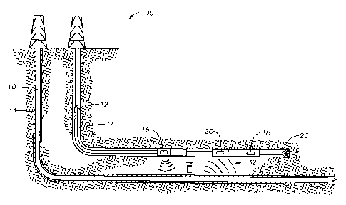
FIGS. lA and 1B illustrate a relative positioning system 100 according to an
exemplary
embodiment of the present disclosure. In this embodiment, a producer well 10
is drilled using
any suitable drilling technique. Thereafter, producer well 10 is cased with
casing 11. An
injector well 12 is then drilled using drilling assembly 14 which may be, for
example, a logging-
25 while
drilling ("LWD") assembly, measurement-while drilling assembly ("MWD") or
other
desired drilling assembly having a bit 23 at its distal end. Although injector
well 12 is described
as being subsequently drilled, in other embodiments producer well 10 and
injector well 12 may
be drilled simultaneously.
In this exemplary embodiment, drilling assembly 14 includes a bottom hole
assembly
30 having one
or more magnetic dipole transmitters 16 and one or more magnetic dipole
receivers
4
CA 02921158 2016-02-10
WO 2015/047865 PCT/US2014/056296
18. In those embodiments utilizing two transmitters 16, the transmitters are
positioned in non-
parallel directions (orthogonal directions, for example) in relation to one
another such that the
transmitted fields can be decoupled in two orthogonal directions in order to
achieve the
measurement of the azimuthal angle of producer well 10. In order to simplify
the decoupling
process, the transmitters may be positioned in orthogonal relationship to one
another. In the
following description, the transmitters and receivers may be referred to as
being orthogonally
positioned in relation to one another; however, in alternative embodiments,
the
transmitters/receivers may be positioned at other non-parallel orientations
relative to one
another. As shown in FIG. 1B, drilling assembly 14 includes transmitters 16a,b
orthogonally
io positioned.
Thus, in this example, at least four magnetic dipole receivers 18a-d arc
positioned
along drilling assembly 14 in order to take the gradient measurements. The
receivers 18a-d are
radially separated along drilling assembly 14 such that the gradient field may
be measured. In
this example, four bucking receivers 20 are positioned adjacent to receivers
18 in order to
eliminate the direct signal from transmitters 16.
As will be described in greater detail below, during an exemplary drilling
operation
using relative positioning system 100, drilling assembly 14 is deployed
downhole to drill
injector well 12 after, or contemporaneously with, the drilling of producer
well 10. In order to
maintain injector well 12 at the desired distance and direction from producer
well 10, relative
positioning system 100 activates transmitters 16 that produce an electric
field E which induces
a current along target casing 11 of producer well 10 that results in a
magnetic field 32 radiating
from target casing 11. The radially separated receivers 18 then sense the
magnetic field 32 and
the associated gradient field. Local or remote processing circuitry then
utilizes the gradiometric
data of the received magnetic field to determine the distance and direction to
producer well 10.
Once the relative position is determined, the circuitry generates signals
necessary to steer the
drilling assembly 14 in the direction needed to maintain the desired distance
and direction from
producer well 10.
FIG. 2 is a block diagram of processing circuitry 200 utilized in a relative
positioning
system, according to certain illustrative embodiments of the present
invention. A system
control center 24 that manages the operational procedures is shown. In this
example,
transmitters 16 consist of two coils in orthogonal directions to achieve the
measurement of the
5
CA 02921158 2016-02-10
WO 2015/047865 PCT/US2014/056296
azimuthal angle of producer well 10. In other embodiments, however,
transmitters/receivers
may be realized as for example, solenoids, magnetometers, or a variety of
other realizations that
approximate magnetic dipoles. Therefore, receivers 18 may contain at least
four coil antennas
for the gradient measurements. Elimination of direct signal from transmitters
16 to the
receivers 18 may be accomplished using bucking coils 20; in other cases,
direct signal
elimination may be accomplished using alternative techniques, such as an
analytical calculation
of this effect. In those embodiments utilizing bucking receivers 20, receivers
18 shown in FIG.
2 would also include data from bucking receivers 20.
Communications unit 26 facilitates the interaction between system control
center 24
io and transmitter coils 16 & receiver coils 18. A visualization unit (not
shown) may be connected
to communications unit 26 to monitor the data; for example, an operator may
intervene the
system operations based on this data. System control center 24 also interacts
with one or more
data processing units 28 and one or more data acquisition units 30. Data
processing unit 28
may convert the received data into information giving the target's position
and direction.
Thereafter, results may be displayed via the visualizing unit. System control
center 24 can be
located at the surface or in the well, in which case processed data is
communicated to the
surface.
As previously mentioned, drilling assembly 14 may include on-board circuitry,
along
with necessary processing/storage/communication circuitry, to perform the
calculations
described herein. In certain embodiments, that circuitry is communicably
coupled to one or
more magnetic dipole transmitters 16 utilized to generate electromagnetic
fields, and also
likewise coupled to magnetic dipole receivers 28 in order to process the
received
electromagnetic waves 28. Additionally, the circuitry on-board drilling
assembly 14 may be
communicably coupled via wired or wireless connections to the surface to
thereby
communicate data back uphole and/or to other assembly components (to steer a
drill bit
forming part of assembly 14, for example). In an alternate embodiment, the
circuitry necessary
to perform one or more aspects of the techniques described herein may be
located at a remote
location away from drilling assembly 14, such as the surface or in a different
wellbore. For
example, in certain embodiments, the transmitter may be located in another
well or at the
6
CA 02921158 2016-02-10
WO 2015/047865 PCT/US2014/056296
surface. These and other variations will be readily apparent to those
ordinarily skilled in the art
having the benefit of this disclosure.
Although not shown in FIG. 2, the on-board circuitry includes at least one
processor
and a non-transitory and computer-readable storage, all interconnected via a
system bus.
Software instructions executable by the processor for implementing the
illustrative relative
positioning methodologies described herein in may be stored in local storage
or some other
computer-readable medium. It will also be recognized that the positioning
software
instructions may also be loaded into the storage from a CD-ROM or other
appropriate storage
media via wired or wireless methods.
Moreover, thosc ordinarily skilled in the art will appreciate that various
aspects of the
disclosure may be practiced with a variety of computer-system configurations,
including hand-
held devices, multiprocessor systems, microprocessor-based or programmable-
consumer
electronics, minicomputers, mainframe computers, and the like. Any number of
computer-
systems and computer networks are acceptable for use with the present
disclosure. The
disclosure may be practiced in distributed-computing environments where tasks
are performed
by remote-processing devices that are linked through a communications network.
In a
distributed-computing environment, program modules may be located in both
local and remote
computer-storage media including memory storage devices. The present
disclosure may
therefore, be implemented in connection with various hardware, software or a
combination
thereof in a computer system or other processing system.
Now that various embodiments have been described, the methodology by which
relative
positioning is determined will now be described. FIG. 3 illustrates a
simplified illustrative
embodiment of a relative positioning system that will be used to describe a
methodology of the
present disclosure. Here, injector well 12 and drilling assembly 14 are not
shown for simplicity.
Nevertheless, a crossection of a homogeneous formation (save for target well
10, transmitters
16 and receivers 18) in the x-z plane is depicted. In this example, a
transmitting coil 16 with a
magnetic moment in the y-direction (i.e., a coil that lies in the x-z plane)
produces an electric
field (E) around it. A target well 10 whose principle axis is in z-direction
is also shown. Wells
generally have elongated metallic conductive bodies (such as steel casings)
around them to
fortify the well structure and prevent collapsing of the borehole wall. Since
casing is much
7
CA 02921158 2016-02-10
WO 2015/047865 PCT/US2014/056296
more conductive than the formation around it, a strong coupling of the
electric field to target
casing 11 occurs.
The coupling of the electric field produces a conduction current on target
casing 11
which would then induce a magnetic field 32 around casing 11 whose magnitude
can be found
via the Biot-Savart law. If the induced current was constant, Biot-Savart law
would reduce to
the Ampere's law. In practical situations, current induced on casing 11 is not
constant, but for
our purposes we may assume that field at a point F is given by:
(7") = ______________ eff
27rR Eq.(1),
with little loss of accuracy where H is the magnetic field, Jeff is an
effective current, and R is the
io radial distance from target well 10 to point F.
OiNF)
The gradient of the magnetic field at the same location, al? , is given by:
Oiii(F) Ieff
OR 2n-R2 Eq.(2).
ojiv)
By taking the ratios of = to OR , the radial distance to target well 10 can
be
determined as follows:
iNT)
R=
6i7V)
OR Eq.(3).
An illustrative design of receivers 18 will now be described. As described
herein, the
receivers are magnetic dipole realizations such as, for example, coils,
solenoids, etc. In one
embodiment, coil antennas having a magnetic moment in a certain direction are
used. As a
result, the coils are only sensitive to the component of the magnetic field in
that direction. If
this direction is called u, component of magnetic field in that direction can
be written as:
H.
(Oh
27rR Eq.(4).
8
CA 02921158 2016-02-10
WO 2015/047865 PCT/US2014/056296
Similarly, if two receiver coils (with the same magnetic moment) are radially
separated
by a very close distance in direction v, their difference is a very good
approximation to the
component of the gradient of the magnetic field in that direction. Assuming u
and v are two of
the axes in the Cartesian coordinate system, the gradient in direction v can
be written as
follows:
eff rt
___________________ = )(al's) + 0.00 4)1
av 27rR2 Eq.(5).
In Cartesian coordinates, and can be written as:
P = I cos(0) + j)sin(D)
= sin(0) + j) co s(01)) Eq.(6),
where (1) is the azimuth angle of receiver 18 with respect to casing 11; that
is, the angle
between the projection of the measured magnetic field vector onto the x-y
plane of the
coordinate system of receiver 18 and the y-axis.
If the receiver coils have their magnetic moments in y-direction and they arc
radially
separated in the x-direction as shown in FIG. 3, Equation 5 can be evaluated
as:
'or cos(0)
ax 27cR2 sin(0)2 ¨cos(P)2_ Eq. (7),
from which two observations may be made. First, the gradient is zero when (I)
is 90 nx180
(n E Z), which is the case when magnetic field does not have any y component.
Second, when
(I) is 45 nx90 (fl Z), the gradient calculation "blows up", preventing the
range calculation
for this angle.
To prevent the blind spots that are suggested by Equation 7, an illustrative
receiver
design is shown in FIG. 4, which shows a magnetic dipole receiver
configuration useful to
eliminate blind spots, according to certain illustrative embodiments of the
present disclosure.
As shown in FIG. 4, coil receivers 18 are shown as boxes around the body of a
bottom hole
assembly (not shown) in this figure for illustration purposes. Receivers 18
are named according
to the gradient direction. For example, gradient in y-direction can be found
by finding the
difference of the fields at the radially separated coil r and coil Y. This
configuration will
allow gradient measurement to be made in 450 intervals, eliminating any
possible blind spots.
9
CA 02921158 2016-02-10
WO 2015/047865 PCT/US2014/056296
Still referring to FIG. 4, it can be seen how that each receiver pair (r/Y-,
X41K, etc.) is
radially separated in a direction that is transverse (perpendicular, for
example) to the axis of the
bottom hole assembly (the axis of the bottom hole assembly is along the z
direction.).
Therefore, during drilling operations, the magnetic moment of each receiver
pair remains
oriented in a direction transverse to both the axis of the bottom hole
assembly and the direction
of the radial separation of the receiver pairs. As a result, the gradient of
magnetic field 32 may
be measured.
As previously described, bucking receivers 20 are utilized in certain
embodiments to
eliminate the direct signal from transmitters 16. Bucking receivers 20 are
also magnetic dipole
io
realizations, such as coils, solenoids or magnetometers. Determination of the
range requires
that the magnetic field due to the current induced on target casing 11, as
well as its gradient, is
measured at a point as given in Equation 3. However, receivers 18 also measure
the direct
signal created by transmitter 16, complicating the analysis. To eliminate this
direct signal,
several approaches may be considered. One illustrative approach is calculating
the field of
transmitter 16 at receivers 18 analytically, and subtract this value from the
gradient
measurements. Note that this illustrative approach requires knowledge of the
formation
properties, as will be understood by those ordinarily skilled in this art
having the benefit of this
disclosure.
An alternative illustrative approach is to utilize bucking receivers 20, which
are wound
in opposite direction from the receivers 18 and located in such a way that the
in-air imaginary
component of the direct signal between the receiver 18-bucking receiver 20
combination is
cancelled. Although in formations that are different than air, this
cancellation is disturbed, in
most cases effects are small. To show these effects, consider the example
shown in FIG. 5.
For simplicity, in this situation, both target casing 11 along well 10,
transmitters 16 and
receivers 18 lie on the same x-z plane. In other words, in Equation 6, al is
equal to zero.
Thus, consideration of only transmitters 16 and receivers 18 with their
magnetic moments my-
direction is enough for range determination.
Still referring to the example in FIG. 5, target casing 11 has a 4" radius,
and a resistivity
per unit length value of 5x 10-50./m. The length of the illustrative target is
15000 feet.
3o Transmitter
coil 16 is assumed to be located directly below the mid-point of target casing
11 at
CA 02921158 2016-02-10
WO 2015/047865 PCT/US2014/056296
a distance of R as shown in FIG. 5. Transmitter coil 16 has 100 turns and a
radius of 4".
Receiver coils 18 are at a distance of 100' from transmitter 16 in the z-
direction, and they have
the same radius and number of turns as transmitter 16. Bucking coils 20, when
used, are
assumed to be at a distance of 99' from transmitter 16 (and 1' from receivers
18), and their
magnetic moments are adjusted such that the direct field cancellation in-air
is achieved (Here, it
should again be noted that imaginary part of the direct field is canceled,
this does not imply the
perfect cancellation of real field.). For simplicity, effects of the tool
structure (other than the
antennas) and the borehole were not considered.
During computer simulations of the illustrative embodiments of the present
disclosure,
to relative dielectric permittivity of the formation was assumed to be 4.
In the example below,
default formation resistivity was 1 fl-m (however, a comparison with the case
of 20 L-2-m is
provided) and the default frequency was 10 Hz (although the case with
frequency equal to 1 Hz
is also shown.). The example case was simulated using a numerical
electromagnetic code.
FIG. 6 is a graph plotting the measured distance as a function of the real
distance of the
tool from the target obtained from simulations of illustrative embodiments of
the present
invention. Ideal case (i.e., measured distance equal to the real distance) is
shown with line A.
Line B depicts the case when analytical direct signal cancellation is employed
for distance
cancellation. Note that even in this case, as the distance from the casing
gets greater
(compared to transmitter-receiver spacing), results begin to deviate from the
ideal. This is due
to the violation of the constant current assumption. Nevertheless, results are
almost identical
with the ideal case up to around 50' (half the distance between transmitter
and receiver).
Line C depicts the same case when direct signal elimination is accomplished by
bucking.
Although results are worse, accuracy improves drastically as the tool gets
closer to the target
where the highest accuracy is needed if the target is to be intersected or to
be avoided. Results
when the operational frequency is decreased to 1 Hz is shown with Line D. In
this case, direct
signal cancellation is better but a substantial improvement could not be
achieved. Finally, case
when bucking is used in a 20 fl-m formation is shown with Line E. In this
case, bucking works
much better and results are a much closer to the ideal.
As seen from Equation 7, the direction to the target should be known for range
calculation. The direction information is also needed to determine the
drilling direction in
11
CA 02921158 2016-02-10
WO 2015/047865 PCT/US2014/056296
intersection applications. Therefore, illustrative embodiments of the present
disclosure also
propose different methodologies by which to determine direction. In one
example, utilizing
external information from another tool (electrode excitation ranging tool,
surface excitation,
etc.) is one such possibility. In an alternate embodiment, the gradient field
32 in FIG. 4 may be
utilized. By taking the angle between the orthogonal components of the
gradient receiver coil
pair, the direction of the target may be determined. Any ambiguity in angle is
also eliminated
since the sign of the gradient tells whichever of the two coils that are used
to determine the
gradient in that direction is closest to the target. Unfortunately, the
gradient signal is small,
thus this approach may lead to large errors in angle determination when the
signal is weak (i.e.,
io faraway from the target where accurate direction determination is
important to approach the
target rather than get away from it.)
In yet another illustrative approach, the total field may be utilized. Here,
the angle
between x and y components of the gradient field will give the direction of
the target.
However, this angle may be between 00 and 90 , thus presenting a large
ambiguity.
Nevertheless, if the cross-coupling components in the total field are also
considered, this range
can be extended from 00 to 180 . An example implementation is realized using:
(I)
4H
= tan-'" _______________ ¨HYX ; If Re{Hyx +H xy}<0
,Hyy¨Hxy
0=180 ¨ tan-, H __________________ ; o.w.
Hyy¨Hxy
Eq.(8).
Note that signs of the fields in this equation depend on the particular
convention used. In
Equation 8,14 refers to the field measured by the receiver with magnetic
moment in direction j
corresponding to the transmitter in direction i. The 1800 ambiguity can then
be eliminated by
using either the gradient information or looking at the temporal change of the
calculated range.
In general, some apriori information about the position of the target should
be available as well,
thus this ambiguity is not a huge concern in most practical cases.
A two dimensional example is useful in demonstrating the application of
direction
information into ranging. Consider the case of intersecting a blown out well
by a relief well.
FIG. 7 illustrates a path that the illustrative relief well may follow. In
this figure, the blown out
well is assumed to be at the center A of the coordinate system lying in z-
direction, and the relief
12
CA 02921158 2016-02-10
WO 2015/047865 PCT/US2014/056296
well B follows a helical path in order to intersect it. It is assumed that
relief well B remains
parallel to blownout well A during the operation. Simulation parameters are
those shown in
FIG. 5; however, formation resistivity is selected to be 20 SZ-m. Also, dG
(distance between
gradient coils) is 4-2- times 8" for the gradient operation in (x+y) and (x-y)
directions, while it
remains 8" for x- and y- directed gradients.
FIG. 8 plots the calculated distance from relief well B to blownout well A
versus the
real distance for gradient measurements in different directions. The measured
distance to the
casing for gradient measurements in x (A), y (B), x+y (C) and x-y (D)
directions as a function
of real distance between the relief well and the blownout well is shown.
Direction to target was
calculated using the total field method described above. This direction
information is also used
in the range calculation as in Equation 7. As expected, gradients in different
directions are not
accurate at all distances; since the azimuth angle (1) with respect to the
target changes with
distance. However, it is possible to select the most accurate distance using
the azimuth
information. One example of how to select the most accurate distance component
is given as
follows:
Use gradient in x direction; If mod(41,180) 22.5 I mod(F,180) > 157.5
Use gradient in (x + y) direction; If mod(0,180) > 22.5 & mod(,180) 67.5
Use gradient in y direction; If mod(0,180)> 67.5 & mod(0,180) 112.5
Use gradient in (x - y) direction; If mod(q),180) >112.5 & mod(1,180)
157.50
Eq.(9).
Using this selection criterion for the results shown in FIG. 8, a single
distance to target
result may be obtained as shown in FIG. 9. This result is shown in the
"stitched" result line.
zo For comparison, ideal case is shown as a solid line. It can be seen that
stitched results are a
good approximation to the real distance and this approximation gets more
accurate as the
target is approached.
Note that Equation 9 allows azimuth angle to be
known with a 1800 ambiguity.
Thus, the angle found using Equation 8 can be directly used to produce FIG. 9.
However, if
apriori information is available or gradient information is used to eliminate
the 180 ambiguity,
FIG. 7 can be reproduced with the calculated path (dashed line) as shown in
FIG. 10, which
illustrates the real path of the relief well versus the calculated path for
the well-intersection
13
CA 02921158 2016-02-10
WO 2015/047865 PCT/US2014/056296
example. Here, it clearly illustrates how the calculated position gets more
accurate as target
well gets closer.
Now that various embodiments have been described, the methodology by which the
well distances are determined will now be described. As previously described,
illustrative
relative positioning systems generally consist of magnetic dipole realizations
(transmitters and
receivers) positioned to induce and measure gradient magnetic fields
propagating from a target
wellbore. FIG. 11 is a flow chart of a ranging method 1100 employed by a
relative positioning
system that utilizes gradiometric data to determine the distance between a
first (i.e., target) and
second wellbore, according to certain illustrative methodologies of the
present invention.
io Again, the specific application may be, for example, a SAGD or
intersection application.
Nevertheless, at block 1102, a first wellbore is drilled using any suitable
methodology.
The first wellbore has a higher conductivity than the surrounding formation
which, for example,
may be achieved using the casing of the first wellbore or through utilization
of some other
elongated conductive body positioned along the first wellbore. At block 1104,
at least two
magnetic dipole transmitters and at least four magnetic dipole receivers are
deployed into a
second wellbore. The receivers are radially separated along the axis of the
bottom hole
assembly. The transmitters and receivers may be deployed in the second
wellbore in a variety
of ways including, for example, along a drilling assembly utilized in a SAGD
operation or a
subsea operation. Note that in alternative methodologies, the first and second
wellbores may
be drilled contemporaneously.
At block 1106, the transmitters are excited to thereby induce a current along
the first
wellbore that results in a magnetic field radiating from the first wellbore.
At block 1108, the
magnetic field is then received using the receivers. At block 1110, using
processing circuitry
operationally coupled to the receivers, the relative positioning system
utilizes the gradiometric
data of the received magnetic field to determine the distance between the
first and second
wellbores. More specifically, here the receivers measure the gradient field of
the received
magnetic field in a radial direction along the bottom hole assembly. After
analyzing the
gradient field, the relative positioning system determines what actions, if
any, are necessary to
maintain or correct the desired drilling path. Such actions may be, for
example, a change in
direction, speed, weight on bit, etc. Thereafter, the algorithm returns to
block 1106 where it
14
CA 02921158 2016-02-10
WO 2015/047865 PCT/US2014/056296
continues to excite the transmitters to continuously monitor and/or adjust the
drill path as
necessary.
Accordingly, embodiments of the present disclosure described herein utilize
magnetic
dipole transmitters/receivers to analyze gradient measurements to thereby
calculate the distance
between a first and second well, without the need to know formation and target
properties. As
a result, the disclosed ranging system offers an accurate measurement of the
range to a target
via widely available and easy to build coil antennas. Furthermore, methods to
eliminate the
direct signal between transmitter and receiver coils have also been disclosed
to facilitate a
practical implementation of this tool.
tip Embodiments and methods described herein further relate to any one or
more of the
following paragraphs:
1. A method for downhole ranging, the method comprising drilling a first
wellbore, the
first wellbore comprising an elongated conductive body, deploying at least two
magnetic dipole
transmitters and at least four magnetic dipole receivers in a second wellbore,
inducing a current
along the first wellbore using the transmitters that results in a magnetic
field being emitted from
the first wellbore, receiving the magnetic field utilizing the receivers,
wherein a gradient field is
measured in a radial direction along the second wellbore, and utilizing the
gradient field to
thereby determine a distance between the first and second wellbores.
2. A method as defined in paragraph 1, further comprising determining a
direction of the
first wellbore in relation to the second wellbore, wherein determining the
direction comprises:
determining a total field of the received magnetic field; determining an angle
between x and y
components of the total field; and utilizing the angle to determine the
direction.
3. A method as defined in paragraphs 1 or 2, further comprising utilizing
the gradient field
to determine a direction of the first wellbore in relation to the second
wellbore.
4. A method as defined in any of paragraphs 1-3, wherein determining the
direction further
comprises determining an angle between orthogonal components of the gradient
field; and
utilizing the angle to determine the direction.
5. A method as defined in any of paragraphs 1-4, wherein determining the
distance
between the first and second wellbores further comprises eliminating a direct
signal emitted
from the transmitters.
CA 02921158 2016-02-10
WO 2015/047865 PCT/US2014/056296
6. A method as defined in any of paragraphs 1-5, wherein the elimination of
the direct
signal comprises calculating a magnetic field of the transmitters at the
receivers; and subtracting
the calculated magnetic field from the received magnetic field.
7. A method as defined in any of paragraphs 1-6, wherein the elimination of
the direct
signal comprises utilizing at least four bucking receivers to cancel an
imaginary component of
the direct signal.
8. A method as defined in any of paragraphs 1-7, wherein the at least four
receivers are
two pairs of magnetic dipole receivers, and determining the distance and
direction further
comprises radially positioning two receivers of the pairs in opposite
directions in relation to a
io measurement center in the second wellbore and determining the gradient
field in a desired
direction by calculating a difference between magnetic fields at each receiver
of the pairs.
9. A method as defined in any of paragraphs 1-8, wherein the first wellbore
is a producer
well; and the second wellbore is an injector well, wherein the method is
utilized in a Steam
Assisted Gravity Drainage operation.
10. A method as defined in any of paragraphs 1-9, wherein the first
wellbore is a blow out
well; and the second wellbore is a relief well.
11. A method as defined in any of paragraphs 1-10, wherein the
transmitters and receivers
are deployed along a drilling assembly, logging assembly or wireline assembly,
the receivers
being radially positioned around a body of the drilling, logging or wireline
assembly.
12. A method as defined in any of paragraphs 1-11, further comprising
steering a drilling
assembly deployed along the second wellbore using the determined distance
between the first
and second wellbores.
13. A method as defined in any of paragraphs 1-12, further comprises
avoiding the first
wellbore using the distance determination.
14. A downhok ranging assembly, comprising a bottom hole assembly
comprising: at least
two magnetic dipole transmitters; and at least four magnetic dipole receivers
radially positioned
around an axis of the bottom hole assembly; and
processing circuitry to implement a
method comprising: inducing a current along a first wellbore using the
transmitters that results
in a magnetic field being emitted from the first wellbore; receiving the
magnetic field utilizing
the receivers, wherein a gradient field is measured in a radial direction
along the bottom hole
16
CA 02921158 2016-02-10
WO 2015/047865 PCT/US2014/056296
assembly; and utilizing the gradient field to thereby determine a distance
between the first and
second wellbores.
15. A downhole ranging assembly as defined in paragraph 14, further
comprising four
bucking receivers positioned along the bottom hole assembly between the
transmitters and
receivers.
16. A downhole ranging assembly as defined in paragraphs 14 or 15, wherein
the bucking
receivers comprise an opposite polarization in relation to the receivers.
17. A downhole ranging assembly as defined in any of paragraphs 14-16,
wherein the
bottom hole assembly is a drilling, wireline, or logging assembly.
m 18. A downhole ranging assembly as defined in any of paragraphs 14-17,
wherein the
transmitters arc positioned in non-parallel relationship to one another along
the bottom hole
assembly; the receivers are radially separated in a direction perpendicular to
the axis of the
bottom hole assembly; and a magnetic moment of the receivers is oriented in a
direction
perpendicular to both the axis of the bottom hole assembly and the direction
of radial
separation.
19. A downho le ranging assembly as defined in any of paragraphs 14-18,
further
comprising eight receivers positioned radially around the body of the bottom
hole assembly at
45 degree intervals.
20. A downhole ranging assembly as defined in any of paragraphs 14-19,
wherein the
transmitters and receivers comprise at least one of a coil, solenoid, or
magnetometer.
Moreover, the methodologies described herein may be embodied within a system
comprising processing circuitry to implement any of the methods, or a in a
computer-program
product comprising instructions which, when executed by at least one
processor, causes the
processor to perform any of the methods described herein.
Although various embodiments and methodologies have been shown and described,
the
disclosure is not limited to such embodiments and methodologies and will be
understood to
include all modifications and variations as would be apparent to one skilled
in the art.
Therefore, it should be understood that the disclosure is not intended to be
limited to the
particular forms disclosed. Rather, the intention is to cover all
modifications, equivalents and
17
CA 02921158 2016-02-10
WO 2015/047865 PCT/US2014/056296
alternatives falling within the spirit and scope of the disclosure as defined
by the appended
claims.
18