Note: Descriptions are shown in the official language in which they were submitted.
DETERMINATION OF THE POSITION OF A VEHICLE
ON OR ABOVE A PLANET SURFACE
BACKGROUND
The invention relates to a device and to a method for determining the position
of a
vehicle on or above a planet surface, in particular in a transport route
network on the
planet surface. The term "vehicles" here is understood to mean aircraft, rail
vehicles,
ships, in particular motor vehicles (private cars, trucks, buses, etc.).
It is known that, for navigation purposes, today's vehicles are provided with
satellite-based and/or inertia-based position determination systems.
Global navigation satellite systems or GNSS (English acronym) are systems for
use on earth, in the air, or in a near-earth orbit for position determination
and navigation
by receiving the signals of navigation satellites. GNSS is a collective term
for the use of
existing and of future global satellite systems such as, for example, GPS
(Global
Positioning System), GLONASS (GLObal NAvigation Satellite System), GALILEO, or
COMPASS). It is known that the satellite-based position determination systems
are
subject to errors (satellite position errors, time drift errors, ionosphere
errors, troposphere
errors, multipath-effect errors) that lead to inaccuracies in the
determination of the
position. These errors can be additive and enable a position determination
with an
accuracy of only 5 m to 150 m. Moreover, it is known that the signals of
satellite position
determination systems can be disturbed by interfering transmitters.
An inertial navigation system (English acronym INS) is a sensor system
enabling
the measurement of movements of bodies that move freely in space. Like the
object to be
monitored, the system also has a total of six kinematic degrees of freedom, of
which three
are translational and three are rotational, which are oriented relative to
three unit vectors
that are also orthogonal with respect to one another. Using this sensor
system, the body
coordinate system can be determined in real time and compared via a kinematic
transformation to a fixed, previously known space coordinate system, which
allows a use
1
CA 2923233 2018-12-17
of the INS as navigation system. The main advantages here include that this
navigation
system can be operated without reference, and thus is also independent of any
locating
signals from the environment.
The term inertial navigation therefore is based on the fact that the
acceleration and
rotation rate sensors required for setting up an INS determine all the changes
of the object
position and orientation, based on accelerations that act on internally
installed,
quantitatively known masses (also referred to as seismic mass), which is based
on the
principle of mass inertia. The presence of a strong sensor drift, whose
erroneous
influence is cumulatively amplified during the course of a measurement, is an
essential
disadvantage of INS, primarily in the case of very low-priced sensors. In
practice, one
couples an INS with other navigational systems. For example, a combination
with a
Global Positioning System (GPS) yields absolute position indications at one
second
intervals, while the INS interpolates intermediate values. Such combined
position
determination systems can be found today in vehicles and aircraft. Inertia-
based position
determination systems are also subject to position errors (resulting
particularly from the
drift error in combination with, for example, the above-mentioned errors in
GNSS
systems).
However, inertial navigation is too expensive for mass use or use in private
cars.
Due to shadowing effects, multiple reception (reflections, multi-path) and
disturbances
(unintentional or also intentional caused by jamming transmitters) of the
reception signal,
the GNSS navigation does not always work in a problem-free and reliable way.
Moreover, for example, the street coordinates in the available data sets (for
example,
from TomTom and Nokia "HERE," formally Navteq) are much too imprecise to keep
a
vehicle in the lane in the case of autonomous steering and to enable drive
control.
Moreover, a position determination based on visual landmarks with the aid of
prominent and precisely surveyed landmarks such as, for example, the tips of
church
steeples, poles and prominent buildings, is known. Photographic views or image
sequences taken from the vehicle are compared to a surrounding area image data
bank,
2
CA 2923233 2018-12-17
=
4.
the landmarks (control points) are found, the angles are determined from which
the
landmarks are seen by the vehicle, and, using the known coordinates of the
control points
and triangulation, the position of the vehicle is determined. However, this
method works
only if the view is suitable. At this time, a data bank with the coordinates
of control
points that can be visually identified satisfactorily from the vehicle does
not exist.
The vehicle positioning by GNSS locating is not sufficiently accurate, and,
alone,
it is not sufficiently failure-proof and reliable. In addition, the road data
have not been
acquired sufficiently precisely and do not contain objects/features for a more
precise
referencing. For high-precision vehicle guidance, for example, in the case of
future
autonomously controlled private cars, aircraft, ships, rail vehicles, the
robust
determination of the current vehicle position with high position accuracy must
be
possible. Thus, in particular, in motor vehicles that are moving autonomously,
driver-
assistance systems for automatically staying in lanes require a multiply
redundant and
secured sensor system for high-precision position determination in real time.
SUMMARY
The problem of the invention is to provide a device and a method for improved
determination of the position of a vehicle on or above a planet surface, in
particular in a
transport route network on the planet surface.
A device-related aspect of the problem is solved by a device for determining
the
position of a vehicle on or above a planet surface, in particular in a
transport route
network on the planet surface. The term "planet surface" here is understood to
mean, in
3
CA 2923233 2019-11-18
general, any surface of a planet, but, in particular, the surface of the
earth. The term
"transport route network" here is understood to mean, in particular, a road
transport route
network or a shipping lane network.
According to one aspect of the invention there is provided a device for
determining the position of a vehicle which moves on the earth's surface in a
transport
route network. The device comprises a first means for determining a first
position P1(t)
of the vehicle, a second means for determining a movement direction BR(t) of
the
vehicle, a third means for providing a number n of fixed point data, wherein
the fixed
point data specify, at least for significant radar objects FRO, arranged in a
stationary
manner on the earth's surface, the radar signature RSFRo, thereof and the
position PFROI
thereof, where i = 1, 2, ..., n, and a radar system having a radar sensor
arranged on the
vehicle for scanning a current surrounding area of the vehicle by means of
radio-
frequency radiation and for continuously detecting radar data obtained in the
process,
wherein, for a number m of radar objects ROk(t) present in the surrounding
area, the radar
signatures RSk(t) thereof and the relative positions APok(t) thereof in
relation to the
vehicle can be determined from the radar data, where k = 0, 1, 2, ..., m. The
radar system
here is configured and set up in such a way that, in the fixed point data,
depending on the
first position Pl(t), from the radar objects FRO,, those radar objects FRO,*
with the
associated radar signatures RSFRoi* and positions PrRol* can be determined,
whose
positions PFROI* are located in a predeterminable area, depending on the
movement
direction BR(t), around the current first position P 1(t) of the vehicle,
wherein the fixed
point data are determined based on radar signatures of the radar objects FRO1
which are
acquired in top view and thereafter being converted into radar signatures
RSrito, that have
the radar objects FRO, in side view; and moreover that the radar signatures
RSFRol* of the
radar objects FRO,* are compared with the radar signatures RSk(t) of the radar
objects
ROk(t), and in the process those radar objects ROk(t)* for which: RSk(t) =
RSFRoe can be
determined, wherein, if this condition is met, it is assumed that for the
radar objects:
ROk(t)* = FRO,*, and for positions PROk(t)* of the radar objects ROk(t)*:
PROk(t)* = PFROI*,
.. and moreover that on the basis of the radar data, the relative positions
APok(o* of the
respective radar objects ROk(t)* relative to the vehicle are determined, and
that, on the
4
CA 2923233 2018-12-17
basis in each case of the positions PRokto. = PFRO1* and the relative
positions APok(t)*, a
second position P2(t) of the vehicle is determined. Finally, the first means
is configured
and set up in such a way that the first position P 1(t) of the vehicle are
corrected on the
basis of the determined second position P2(t) and/or a position warning is
issued if the
first position P1(t) and the second position P2(t) differ from one another by
more than a
predefined limit value.
The first means is preferably a satellite-based or inertia-based position
determination system. The first means therefore enables a determination of the
first
position P1(t) with a given position inaccuracy of AP1(t). As explained in the
introduction, this position inaccuracy is typically in a range of 5 m to
100 m.
The second means advantageously comprises a magnetic field sensor and/or an
inertial system and/or a GNSS system. The movement direction or the travel
direction is
typically determined in contemporary vehicles in any case and is provided in
an
advantageous refinement by the corresponding vehicle system.
The third means provides the fixed point data. These fixed point data specify,
at
least for significant radar objects (FRO,) arranged in a stationary manner on
the planet
surface, the radar signature (RSrizo,) thereof and the positions (PFRoi)
thereof. The
positions PFRoi are here advantageously indicated with a position accuracy in
the range of
<50 cm, <30 cm, <25 cm, < 10 cm, or < 5 cm. The radar signature RSFRo, depends
in
particular on the size, the shaping and the materials of which the radar
object FRO,
consist, and enables in particular an identification and differentiation of
individual radar
objects FRO,.
In the present case, the radar objects FRO, are advantageously objects that
reflect
the impinging radio-frequency radiation (microwaves). The main reflected beam
angle of
the backscattered radar energy here depends on the dielectric properties and
the
mechanical properties of the respective radar object FRO,. Using a radar
sensor, the best
detected surfaces are metal surfaces that are oriented so that they directly
reflect incident
5
CA 2923233 2018-12-17
microwaves from the radar. For the present application, advantageously only
radar
objects FRO, that can be acquired or seen from the vehicle by the radar system
are used,
since they have an amplitude that is clearly greater than the noise level or
the
backscattering of the background. In the present case, they are therefore
referred to as
"significant" radar objects. Advantageously, on the planet surface, adjacently
arranged
radar objects are selected (and thus relative to the radar objects FRO, of the
fixed point
data) so that they have different and thus easily and unequivocally
identifiable radar
signatures RSFRoi. This simplifies an unequivocal identification of the radar
objects FRO,.
Advantageously, the fixed point data are generated on the basis of radar data
in
which the transport route network and the radar objects FRO, arranged therein
are
represented in top view. Advantageously, the radar data are acquired here by
means of
aircraft-borne or satellite-borne radar sensors. For this purpose, methods are
known by
means of which radar objects FRO, can be acquired by radar satellites or
aircraft-borne
radar sensors with a position accuracy of a few centimeters, in particular up
to 2-10 cm.
An area-wide determination of radar objects FRO, is thus feasible within a
relatively
short time (a few weeks) for entire countries or continents, so that it can be
ensured that
the fixed point data are sufficiently up-to-date.
High-precision absolute coordinates of the radar objects FRO, from satellite
data
can thus be determined very cost effectively worldwide. While optical images
have a
relatively uniform brightness, in radar images objects made of metal
(guardrails, poles,
lamps, sign gantries, bridge railings appear much more strongly than the
background
image with the road cover and the vegetation. Therefore, they are considerably
easier to
.. identify. Moreover, building edges and comers are very good scatterers.
This often
results in so-called "radar point targets," which are significantly smaller
than a resolution
cell (1 m x 1 m TerraSAR-X Spotlight Mode image). The work of Balss et al.
(DLR MF-
SAR) has shown that such "point targets" can be determined in TerraSAR-X and
TanDEM-X radar images with an accuracy of a few centimeters (see also
(http://elib.d1r.de/82537/).
6
CA 2923233 2018-12-17
Naturally, the radar signatures of the radar objects FRO,, acquired in top
view,
depending on the concrete application, first have to be converted into the
radar signatures
RSFRo, which can be detected by the vehicle. For example, in the case of an
application
for motor vehicle transport, the radar sensor of the motor vehicle acquires
the radar
.. objects FRO, typically in a side view, so that the radar signatures
acquired in top view
have to be converted into radar signatures RSFRo, that have the radar objects
FRO, in side
view. Naturally, the above-mentioned easy identifiability of the radar objects
FRO, by
corresponding radar signatures RSFRoi, and the requirement that the radar
amplitude
acquired by the radar sensor is clearly above the noise level or the
backscattering of the
.. background, in this case relate to side views of the radar objects FRO, and
to those views
of the radar objects FRO, that are acquired by the radar sensor arranged on
the vehicle,
respectively.
Advantageously, special radar reflectors, as radar objects FRO,, are added in
appropriate positions and at appropriate spacings on the planet surface, for
example,
along roads of a highway network. In this way, it is possible to ensure that
along certain
routes of the highway network, a continuous determination of the second
position P2(t)
with a corresponding high position resolution is possible. This is
advantageous
particularly for driver assistance systems of motor vehicles which require a
high-
.. precision determination of the position of the vehicle (for example,
autonomous driving).
The radar system advantageously comprises an evaluation computer, by means of
which first, on the basis of the current first position P1(t) determined by
the first means,
in the fixed point data Pl(t), a determination is made, from the radar objects
FRO, stored
there, of those radar objects FRO,* with the associated radar signatures
RSFRoi* and
positions PFROI*, whose positions PFRO1* are in a predeterminable range,
depending on the
movement direction BR(t), around the current first position P1(t) of the
vehicle. With the
"error-affected" first position P1(t) an approximate position of the vehicle
is available.
This "approximate" first position P1(t) is used only for selecting from the
fixed point data
those radar objects FRO,* with the associated radar signatures RSFRoi* and
exact
positions PFROi* that should be detectable from the vehicle independently of
the current
7
CA 2923233 2018-12-17
movement direction (travel direction in the case of motor vehicles) of the
first position
Pl(t). These selected radar objects FRO,* are marked with a star in the
present case.
The selected radar objects FRO,* and the radar signatures RSFR0,* thereof are
moreover compared by the radar system/evaluation computer with the radar
signatures
RSk(t) of the radar objects ROk(t) that were currently acquired by the radar
sensor. Here,
those radar objects ROk(t)* whose radar signature RSk(t) corresponds to a
radar signature
RSFRol*, i.e., for which: RSk(t) = RSFao,*, are determined. If this condition
has been met,
it is assumed, furthermore, that for the radar objects: ROk(t)* = FRO,*, and
for positions
PROk(t)* of the radar objects ROk(t)*: PROk(t)* PFROi*. In other words, to the
extent that the
comparison of a radar signature RSk(t) acquired by the radar sensor with a
selected radar
signature RSFRo,* results in a clear agreement, an identification of the
associated radar
object FRO,* in the radar data acquired by the radar sensor is assumed.
If, in the comparison, no unequivocal identification of a radar signature
RSFR0,* is
achieved, the acquisition of current radar data is continually pursued by
means of the
radar sensor as is the subsequent above-described evaluation until at least
one radar
object FRO,* = ROk(t) has been identified unequivocally.
An advantageous refinement of the device is characterized in that the fixed
point
data comprise optical data OD, for at least some significant radar objects
FRO, which
visually characterize the corresponding radar objects FRO,, in that the radar
system has
an optical sensor for the continuous acquisition of image data BD(t) of the
current
surrounding area of the vehicle, and in that the radar system is configured
and set up in
.. such a way that the image data BD(t) are used for the verification of radar
objects ROk(t)
and FRO,* detected in the current surrounding area of the vehicle. In this
refinement, an
additional optical verification of a radar object FRO,* = ROk(t) therefore
occurs. As a
result, the robustness and the reliability of the determination of the second
position P2(t)
are increased. Advantageously, the image data BD(t) acquired by the optical
sensor also
have an infrared light component. By the identification of at least one radar
object FRO,*
8
CA 2923233 2018-12-17
= ROk(t)*, the position PRok(i). = PFROi* associated with this radar object is
known with
high position accuracy from the fixed point data.
Moreover, the radar system is configured and set up according to the invention
in
such a way that, on the basis of the radar data acquired by the radar sensor,
the relative
positions 6,Pok(t)* of the respective radar objects ROk(t)* = FRO,* relative
to the vehicle
are determined. For this purpose, today's radar sensors allow a distance
determination
with an accuracy of a few centimeters and an angular resolution of 10 or less.
Thus, by
triangulation (position, distance, angle) in each case on the basis of the
respective
positions PRokw. = PFROI* and the associated relative positions APokor, a
second position
P2(t) of the vehicle is determined. If only one radar object ROk(t)* = FRO,*
is identified,
one gets, from the position PRokor = PFROI*, from the distance determined from
the radar
data, and from the angle relative to the one radar object ROk(t)* = FRO,*, the
position
P2(t) with a position accuracy in the range of 2 to 50 cm, for example. If
several radar
objects ROk(t)* = FRO,* are identified, then one gets, from the corresponding
positions
PROk(t)* = PFROi*, and from the distances and angles determined from the radar
data
(horizontal angles/azimuth angles), first several second positions P2k(t) from
which the
second position P2(t) is determined, for example, by averaging and other
algorithms.
The first means is configured and set up according to the invention in such a
way
that the first position P1(t) of the vehicle can be corrected on the basis of
the determined
second position P2(t) and/or a position warning can be issued if the first
position P1(t)
and the second position P2(t) differ from one another by more than a
predefined limit
value.
Advantageously, a correction of the first position P1(t) of the vehicle on the
basis
of the determined second position P2(t) occurs only if a difference in the
values IP1(t) ¨
P2(t)( exceeds a predefined first limit value. This first limit value is
advantageously
determined by the position inaccuracy of the second position P2(t).
Advantageously, in
addition, a position warning is issued if the difference in the values IP1(t)
¨ P2(t)( exceeds
a second limit value. As a result, the driver of the vehicle is at least
notified that the
9
CA 2923233 2018-12-17
device has detected a difference between the first position P1(t) and the
second position
P2(t) that goes beyond the second limit value.
The proposed device is thus used, in particular, for a position update of the
first
means, i.e., of the first position P1(t) determined by the first means, by a
second position
P2(t) which is determined on the basis of fixed point data, i.e., high-
precision radar
control points (radar objects FROi), and travel time and angle measurements
determined
by the radar sensor and radar signatures acquired by triangulation. For the
detection and
correct correlation of the radar objects FRO, to the radar objects ROk(t)
detected by the
radar sensor, the device needs to know the approximate position (first
position Pl(t)).
By means of the proposed device, it is possible to construct a worldwide
control
point network of radar objects FRO, along the most important roads, for
example, from
already available and archived radar images. This method is particularly cost
effective,
since no in-situ measurements or expensive overflying operations are needed.
As a result,
the possibility of high-precision navigation that is independent of GNSS can
be created,
even for regions of the world that are remote or difficult to access.
The radar sensors needed on the vehicle (near-range radar, long-range radar
LLR,
multi-mode radar) are in any case often already present in modern road
vehicles for
collision warning. For operation during daylight, cameras can also be used for
recording
and surveying the control points.
The advantages of the proposed device are that said device works independently
of weather and lighting conditions, and the distribution and the density of
the radar
objects FRO, on the planet surface are much clearer (more selective and
prominent) than
with optical methods.
The invention relates moreover to a vehicle, in particular a motor vehicle,
with a
device as described above.
CA 2923233 2018-12-17
A method-based aspect of the problem is solved by a method for determining the
position of a vehicle on the earth's surface in a traffic transport route.
The proposed method has the following steps: determination of a first position
P1(t) of the vehicle; determination of a movement direction BR(t) of the
vehicle;
provision of a number n of fixed point data, wherein the fixed point data
specify, at least
for significant radar objects (FRO,) arranged in a stationary manner on the
planet surface,
the radar signature (ZSFkol) thereof and the position (PFRoi) thereof, where i
1, 2, ..., n;
with a RADAR system fixed to a car, scanning of a current surrounding area of
the
vehicle by means of radio-frequency radiation and continuous acquisition of
radar data
obtained in the process, wherein, from the radar data, for a number m of radar
objects
ROk(t) present in the surrounding area, the radar signatures RSk(t) thereof
and the relative
positions APok(t) thereof in relation to the vehicle are determined, where k =
0, 1, 2, ..., m;
in the fixed point data, depending on the first position Pl(t), from the radar
objects FRO,,
determination of those radar objects FRO,* with the associated radar
signatures RSFRol*
and positions PFRoi*, whose positions PFROI* are located in a predeterminable
range,
depending on the movement direction BR(t), around the current first position
P1(t) of the
vehicle, wherein the fixed point data are determined based on radar signatures
of the
radar objects FROi which are acquired in top view and thereafter being
converted into
radar signatures RSFROi that have the radar objects FROi in side view;
comparing of the
radar signatures RSFRo,* of the radar objects FRO,* with the radar signatures
RSk(t) of the
radar objects ROk(t), and in the process determination of those radar objects
ROk(t)* for
which: RSk(t) = RSFRo,*, wherein, if this condition has been met, it is
assumed that for the
radar objects: ROk(t)* = FRO,*, and for positions PROk(t)* of the radar
objects ROk(t)*:
PRokar = PFROI*; based on the radar data, determination of the relative
positions APokor of
the respective radar objects ROk(t)* in relation to the vehicle; and on the
basis in each
case of the positions PRokor and the relative positions APok(t)* determination
of a second
position P2(t) of the vehicle, wherein the first position P1(t) of the vehicle
is corrected on
the basis of the determined second position P2(t) and/or a position warning is
issued if
the first position Pl(t) and the second position P2(t) differ from one another
by more than
a predefined limit value.
11
CA 2923233 2018-12-17
A refinement of the proposed method is characterized in that the fixed point
data
are generated on the basis of remote exploration radar data, in which the
planet surface
and the radar objects FRO, arranged thereon are imaged in a top view.
A refinement of the proposed method is characterized in that the remote
exploration radar data are acquired by an aircraft-borne or a satellite-borne
radar sensor.
A refinement of the proposed method is characterized in that the fixed point
data
provided comprise optical data OD, for at least some significant radar objects
FRO,,
which visually characterize the corresponding radar objects FRO,, in that,
with an optical
sensor, image data BD(t) of the current surrounding area of the vehicle are
continuously
acquired, and the image data BD(t) are used for the verification of radar
objects ROk(t)
detected in the current surrounding area of the vehicle.
Additional advantageous refinements and advantages result from an analogous
and corresponding application of the explanations made above in connection
with the
proposed device.
With the present invention, an additional method, which, in particular,
supplements the established methods such as GNSS, is described, which provides
high-
precision coordinates and position data for the orientation of the vehicle. As
a result, the
position determination becomes safer, more reliable, more robust and more
accurate. This
is a requirement in particular for the application in autonomous operation of
vehicles
(road vehicles, rail vehicles, aircraft).
The problem of the invention is moreover solved by a computer system, with a
data processing device, wherein the data processing device is designed so that
an above-
described method is carried out on a data processing device.
12
CA 2923233 2018-12-17
In addition, the problem of the invention is solved by a digital storage
medium
with electronically readable control signals, wherein the control signals can
cooperate
with a programmable computer system so that an above-described method is
carried out.
Furthermore, the problem of the invention is solved by a computer program
product with a program code stored on a machine-readable support for carrying
out an
above-described method when the program code is executed on a data processing
device.
Finally, the invention relates to a computer program with program codes for
carrying out an above-described method when the program runs on a data
processing
device. For this purpose, the data processing device can be designed as any
computer
system known from the prior art.
Further advantages, features and details result from the following
description, in
which ¨ optionally in reference to the drawing ¨ at least one embodiment
example is
described in detail. Identical, similar and/or functionally equivalent parts
are provided
with the same reference numerals.
BRIEF DESCRIPTION OF TITLE DRAWINGS
In the drawings:
Fig. 1 shows a diagrammatic representation of a proposed device,
Fig. 2 shows a diagrammatic representation of a flow chart of a proposed
method.
DETAILED DESCRIPTION
As an example embodiment, first an add-on and independently operating
navigation system for vehicles is presented, which is all-weather and night
capable, and
which continually monitors, and, if needed, improves position data already
present in the
vehicle and issues a warning if serious deviations in the determined position
data occur.
The applications of this embodiment example lie in the navigation of vehicles
of all types
(private cars, trucks, in particular autonomous vehicles, ships, aircraft,
drones, etc.), i.e.,
13
CA 2923233 2018-12-17
in cases where an interference resistance is important and several systems
working as
independently of one another as possible continually compare their respective
position
results to one another. An important application is in so-called "driver
assistance
systems" which allow completely autonomous navigation and driving of a motor
vehicle.
In order to achieve all-weather and night capacity, an automotive radar is
used,
similar to the one already in use for so-called lane change assistance and for
collision
avoidance in vehicles. The automotive radar is used for measuring the range
and the
horizontal viewing angle (azimuth) of a prominent radar object and for
measuring its
radar signature in the viewing area of the road. For the evaluation, radar
objects that can
be seen easily with the radar sensor are selected. The radar sensor as a rule
acquires metal
objects such as traffic signs, sign gantries, light poles, guardrails, noise
protection walls,
as well as general building edges.
The coordinates of the radar objects/control points relate preferably to point
sources on such objects made of metal, which are known precisely: by the
proposed
device, so that, by means of the radar measurement (range and angle in
relation to the
radar object), the vehicle position can be determined. If several radar
objects/control
points can be seen simultaneously by the radar sensor, then, by triangulation,
one's own
position can be determined even more precisely and the weighting of the
measured value
is higher than with the other navigation systems.
In a preparatory step, a control point database (fixed point data) for radar
objects
(and optical sensors) is constructed. It contains the precise coordinates of
the prominent
points (so-called radar reflectors), which as a rule are visible from the
road. The proposed
device in the vehicle uses the current (and possibly only approximately known)
position
data of the vehicle (first position Pl(t)) which is supplied and which is to
be verified (by
other systems), and extracts from the control point database the control
point/fixed point
data that are presumably easily seen from the vehicle, as well as their
coordinates.
14
CA 2923233 2018-12-17
The automotive radar acquires the radar objects in the surrounding area and,
with
the corresponding coordinates from the fixed point data, determines
approximately their
position and compares them to the control point information extracted from the
database.
If the difference does not exceed a predeterminable error measure, then it is
assumed that
a subset of the radar objects stored in the database was detected. So-called
"radar clutter,"
that is to say back scattering from other objects but also interferences must
be eliminated
in this process and not be used. The proposed radar method has advantages,
since the
control point/radar objects can be detected more easily here than in an
optical image.
If it is ensured that the automotive radar has the correct control
points/radar
objects in the viewing area, the position determination process is reversed
and the high-
precision positions of the control points/radar objects are used in order to
determine the
vehicle position.
The construction of the control point database with the fixed point data can
occur
using measurement vehicles. A measuring vehicle equipped with high-precision
orientation and position sensors travels all the relevant roads, and, using a
high-precision
automotive radar, it acquires all the prominent/significant radar objects in
the surrounding
area of the road. The measurement vehicle can precisely determine the
coordinates of the
radar objects. The vehicles, like the device proposed later, in fact only
require in addition
a relatively cost-effective orientation and position sensor system. Thus, an
investment is
made in expensive but one-time "learning and calibration trips" in order to
save effort in
the mass-produced product.
If one wants to avoid the effort of driving over all the roads, it would be
possible
to fall back on "Google Street View" image data, for example. Using object
recognition
software, the control point/radar objects are identified, and using available
information
(coordinates of the receiving location), the coordinates of the control
point/radar objects
are also determined. By means of a simulator, it is possible to estimate how
the
automotive radar later "sees" the control points. In this manner, objects are
identified that
are known from the optical image measurements and made available for night
travel with
CA 2923233 2018-12-17
the automotive radar. Since no new data have to be collected, this is
presumably the most
cost effective method for constructing control point databases/fixed point
data.
If a measurement of the control point/radar objects on site is not possible
and if no
Street View data are available, as is the case, for example, for legal reasons
in some
countries such as China or in a military use area ("off-road"), image data
from SAR
Radar satellites, such as, for example, the German TerraSAR-X satellites, can
be used in
order to determine high-precision coordinates of the control point/radar
objects FRO.
Progress in the technology has made it possible to indicate coordinates of the
image pixel
with only a few centimeters of error. However, the problem is that the radar
objects are
not distributed evenly in all directions, and therefore, when viewed from
different
directions (from the road or from above), they can exhibit very different
levels of
brightness. In order to be able to use the satellite data nonetheless, the
following three
possibilities exist, which can also be combined.
a) A combination with data of the radar measurement trips. It would be
possible to align, i.e. match, the radar objects found by means of the radar
measurement
vehicles with those from the satellite measurement, and then use the more
accurate
coordinates of the satellite measurement. The matching is also referred to as
"sensor
fusion."
b) A combination with data from the camera measurement trips (Google
Street View). One uses the radar objects found in the optical data, which are
known as
"solid" radar scatterer/reflectors (for example, sign gantries) and matches
these with the
satellite data. By using models concerning the radar back scattering behavior
of these
objects, it can be simulated how the KFZ radar presumably "sees" the objects.
This
option is favored.
c) A combination with optical satellite data. If the area is not
accessible, the
control point/radar objects have to be identified both in satellite images of
radar satellites
and also of optical satellites, and the presumed radar signature for the view
from the road
16
CA 2923233 2018-12-17
must be determined by simulation. This is not too expensive, as one limits
oneself to
well-known objects that always occur in the vicinity of a road (signs,
bridges, guardrails,
power and light poles).
An operational update of the control point database with the fixed point data
is
possible using so-called "crowd sourcing." In order to always keep the fixed
point data
current, unusual features are stored by the proposed device in the vehicle in
a "error
memory" and communicated from time to time (for example, in a database update)
to a
provider. A distinction is made here between the following cases:
a) radar objects that are not visible from many vehicles
b) radar objects that no longer seem to be present at all
c) radar objects that are ranked prominent by many vehicles but that are
not
recorded in the database.
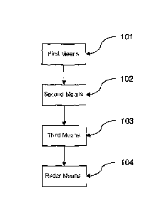
Fig. 1 shows a diagrammatic representation of a proposed device for
determining
the position of a vehicle on or above a planet surface, in particular a
transport route
network on the planet surface, comprising: a first means 101 for determining a
first
position P1(t) of the vehicle; a second means 102 for determining a movement
direction
BR(t) of the vehicle; a third means 103 for providing a number n of fixed
point data,
wherein the fixed point data specify, at least for significant radar objects
(FRO,) arranged
in a stationary manner on the planet surface, the radar signature (RSrizoi)
thereof and the
position (PFao,) thereof, where i = 1, 2, ..., n;
a radar system 104 with a radar sensor arranged on the vehicle for scanning a
current
surrounding area of the vehicle by radio-frequency radiation and for the
continuous
acquisition of radar data obtained in the process, wherein, from the radar
data, for a
number m of radar objects ROk(t) present in the surrounding area, the radar
signatures
RSk(t) thereof and the relative positions APok(t) thereof relative to the
vehicle can be
determined, where k = 0, 1, 2, ..., m, and wherein the radar system 104 is
configured and
set up in such a way that, in the fixed point data, depending on the first
position Pl(t), a
determination is made, from the radar objects FRO,, of those radar objects
FRO,* with
the associated radar signatures RSFRo,* and positions PFROI*, whose positions
PFRO1* are in
a predeterminable range, depending on the movement direction BR(t), around the
current
17
CA 2923233 2018-12-17
first position P1(t) of the vehicle, the radar signatures RSFRol* of the radar
objects FRO,*
are compared with the radar signatures RSk(t) of the radar objects ROk(t), and
in the
process those radar objects ROk(t)* are determined for which: RSk(t) =
RSFRoi., wherein,
if this condition is met, it is assumed that, for the radar objects: ROk(t)* =
FRO,* and for
positions PRokor of the radar objects ROk(t)*: PROk(t)* = PFROt*, on the basis
of the radar
data, the relative positions APok(o* of the respective radar objects ROk(t)*
relative to the
vehicle are determined, and on the basis in each case of the positions
PROk(t)* = PFROi* and
of the relative positions APokor, a second position P2(t) of the vehicle is
determined;
wherein the first means 101 is configured and set up so that the first
position P1(t) of the
vehicle can be corrected on the basis of the determined second position P2(t)
and/or a
position warning can be issued if the first position P1(t) and the second
differ from one
another by more than a predefined limit value.
Fig. 2 shows a diagrammatic representation of a flowchart of a proposed method
for determining the position of a vehicle on or above a planet surface, in
particular in a
transport route network on the planet surface, with the following steps. In a
first step 201,
a determination of a first position PI (t) of the vehicle occurs. In a second
step 202, a
determination of a movement direction BR(t) of the vehicle occurs. In a third
step 203, a
provision of a number n of fixed point data occurs, wherein the fixed point
data specify,
at least for significant radar objects (FRO) arranged in a stationary manner
on the planet
surface, the radar signature (RSI-Roi) thereof and the position (PFRoi)
thereof, where i = 1,
2, ..., n. In a fourth step 204, a scanning of a current surrounding area of
the vehicle
occurs by radio-frequency radiation and continuous acquisition of radar data
obtained in
the process occurs, wherein, from the radar data, for a number m of radar
objects ROk(t)
present in the surrounding area, the radar signatures RSk(t) thereof and the
relative
positions APok(t) thereof relative to the vehicle are determined, where k = 0,
1, 2, ..., m. In
a fifth step 205, in the fixed point data, depending on the first position
Pl(t), from the
radar objects FRO,, a determination occurs of those radar objects FRO,* with
the
associated radar signatures RSFRoi* and positions PFROt whose positions PFROt*
are in a
predeterminable area, depending on the movement direction BR(t), around the
current
first position P1(t) of the vehicle. In a sixth step 206, a comparison of the
radar signatures
18
CA 2923233 2018-12-17
RSFRoo of the radar objects FRO,* with the radar signatures RSk(t) of the
radar objects
ROk(t) occurs, and in the process, a determination occurs of those radar
objects ROk(t)*
for which: RSk(t) = RSFRch., wherein, if this condition is met, it is assumed
that, for the
radar objects: ROk(t)* = FRO,*, and for positions PROk(t)* of the radar
objects ROk(t)*:
PROk(t)* = PFRO1*. In a seventh step 207, on the basis of the radar data, a
determination of
the relative positions APok(t)* of the respective radar objects ROk(t)*
relative to the
vehicle occurs. In an eighth step 208, on the basis in each case of the
positions PROk(t)*
and of the relative positions APokor, a determination of a second position
P2(t) of the
vehicle occurs. In a ninth step 209, the first position Pl(t) of the vehicle
is corrected on
the basis of the determined second position P2(t) and/or a position warning is
issued if
the first position P1(t) and the second position P2(t) differ from one another
by more than
a predefined limit value.
Although the invention has been illustrated and explained in detail by means
of
preferred example embodiments, the invention is nonetheless not limited by the
disclosed
examples, and other variations can be derived therefrom by the person skilled
in the art
without leaving the scope of the invention. Therefore, it is clear that a
plurality of
variation possibilities exists. It is also clear that embodiments mentioned as
examples
really represent only examples that in no way should be considered to be a
limitation of
the scope of protection, the application possibilities or the configuration of
the invention.
Rather, the above description and the description of the figures put the
person skilled in
the art in the position to concretely implement the exemplary embodiments,
wherein the
person skilled in the art, in the knowledge of the disclosed inventive ideas,
can proceed
with a wide variety of changes, for example, with regard to the function or
the
.. arrangement of individual elements mentioned in an exemplary embodiment,
without
leaving the scope of protection defined by the claims and their legal
equivalents such as,
for example, further explanations in the description.
19
CA 2923233 2018-12-17
List of reference numerals
101 First means
102 Second means
103 Third means
104 Radar system
201-209 Method steps
CA 2923233 2018-12-17