Note: Descriptions are shown in the official language in which they were submitted.
¨ 1 ¨
Method and System for Managing Geospatial Deployment
Technical Field
The present invention relates to a method and system for managing geospatial
deployment (i.e. most commonly construction), in particular for the physical
deployment of new assets (whether involving existing assets or otherwise),
such as
assets designed using a geographical information system (GIS), as is of
particular but
by no means exclusive application in geographically distributed construction
projects
that involve high numbers of individual but related tasks.
Background
There are currently a number of substantial telecommunications infrastructure
construction projects, including Australia's National Broadband Network (NBN)
and
New Zealand's Ultra Fast Broadband project. Such projects are unusual¨and
challenging to manage¨as they involve very high numbers of individual but
related
tasks that are geographically widely distributed and which also involve large
extensions
of existing pieces of infrastructure. These problems can lead to cost and time
overruns, problems that heretofore have been inadequately addressed.
For example, one difficulty experienced in the construction of such large
projects arises
from the source data used in the creation of work orders (W0s). Traditionally
WOs are
created from a file received from, from example, a Telco Operator; the file
fully details
what is to be the content of the WO (e.g. "Service Activation required at 55
XYZ St,
between 9 am and midnight, 14 February). In this instance, the scope, duration
and
timing of the WO are provided in a consistent format from which the WO can be
created. However, a project such as the NBN operates contractually at the
geographic
region level and in effect outsources management at the work item (WI) level
to
individual construction contractors. Consequently, if the construction
contractors
choose to use Work Management Systems (WMSs), they must each determine the
details to be included in their own W0s, leading to potential fragmentation of
the
project and the danger of miscommunication.
Date Recue/Date Received 2021-07-19
CA 02936447 2016-07-11
WO 2015/113109
PCT/AU2015/000045
¨ 2 ¨
Summary of the Invention
According to first broad aspect of the invention, there is provided a system
for
designing or managing geospatial deployment, comprising:
an input for receiving design data indicative of a design (such as of a
telecommunciations network) that is to be deployed (or constructed);
a fragmenter configured to fragment the design data into work items, each of
the work items comprising one or more geospatially tagged tasks;
an aggregator configured to analyse the tasks and thereby identifying a type
of
each of the tasks, and to generate one or more geospatially tagged jobs each
comprising one or more of the tasks such that each of the jobs comprises only
tasks of
like type;
an allocator configured to compare the jobs with a database of approved
parties and characteristics of the respective parties, to identify for each of
the jobs at
least one of the approved parties that is fit to implement the respective
jobs, and to
allocate one or more of the jobs to one or more of the parties so identified;
a scheduler configured to determine an optimal implementation schedule of the
jobs; and
a work order generator configured to generate geospatially tagged work orders
according to said implementation schedule, each of said work orders being
indicative
of one or more of said jobs and of one of said parties so identified as fit to
implement
said respective one or more jobs and each of said work orders being suitable
for
transmitting to the party identified in the respective work order.
As mentioned above, the tasks, jobs and work orders are geospatially tagged,
that is,
include data indicative of the geographical location(s) of intended deployment
of the
respective task, job or work order.
Thus, the present invention provides a system (and method) that may be used in
any
suitable phase of the design or management of a geospatial deployment project,
such
as during preliminary design work (including the surveying, development,
production
and approval of a design), immediately prior to commencement of deployment or
during physical deployment of material and labour. In each case, there are a
number
of dependency driven, related activities that may be planned¨or actually
conducted¨
according to the present invention; the results can be used, for example, to
evaluate
the characteristics and/or viability of a project or in the actual deployment
of a project.
The work order generator may be configured to transmit each of the work orders
to the
party identified in the respective work order.
CA 02936447 2016-07-11
WO 2015/113109
PCT/AU2015/000045
¨ 3 ¨
In one embodiment, the system comprises a releaser configured to transmit data
to
each of the parties identified in the work orders indicating that the
respective work
orders should be implemented.
In another embodiment, the characteristics of the parties include a
productivity value
for each task provided by the respective parties.
In an embodiment, the system comprises a progress monitor that receives
implementation progress data from the parties identified in the work orders.
The
characteristics of the parties may include a productivity value for each task
provided by
the respective parties, in which case the progress monitor may determine
productivity
from the progress data for each of the parties identified in the work orders
and update
the productivity values. The allocator may be adapted to allocate or re-
allocate one or
more of the jobs based additionally on the implementation progress data.
In one embodiment, the scheduler determines the implementation schedule
according
to criteria that comprise any one or more of: job dependency, state of
completion, and
capacity of implementation parties. For example, the scheduler may determine
or
update the implementation schedule periodically based on implementation
progress.
In one embodiment, the system includes or is configured to access an element-
to-task
database, and the fragmenter identifies elements of the design in the design
data and
determines the tasks from the elements and the element-to-task database.
In another embodiment, the aggregator identifies a type of each of the tasks
according
to criteria that comprise any one or more of: task location and task
capability
requirements.
In a certain embodiment, the aggregator generates the jobs such that each of
the jobs
once generated has an expected duration that can be accommodated by a
predefined
work period.
In one embodiment, the allocator allocates each of the jobs according to the
one or
more tasks constituting the respective jobs.
The system may include a geospatial output generator configured to receive job
data
indicative of one or more of the jobs or work order data indicative of one or
more of the
work orders, and to generate data adapted for output or display as a map or
CA 02936447 2016-07-11
WO 2015/113109 PCT/AU2015/000045
¨ 4 ¨
superimposed on a map.
In one embodiment, the system includes a variation generator controllable to
add,
delete and alter tasks (including amending the type of a task, the size of a
task and
geospatial information associated with a task). The variation generator is
typically
configured to respond to the addition, deletion or alteration of a particular
task by
correspondingly altering (such as in sequence and characteristics) any tasks
associated with that particular task.
The system may include a jeopardy input for receiving jeopardy data indicative
of one
or more factors that jeopardize the ability of a specific task to be
commenced, thereby
identifying geospatially tasks for consideration by the scheduler. This
enables the
geospatial data handling ability of the system to integrate delays at the task
level in the
scheduling of the work.
In an embodiment, the system comprises a defect rectifier configured to
receive defect
identification data indicative of a defect in a specified asset, to identify
which resource
performed work on the specific asset (typically using the geospatial data held
by the
system), and to control the work order generator to generate one or more
geospatially
tagged defect rectification tasks adapted to remediate or correct the defect.
This allows the system to automatically allocate and release the one or more
defect
rectification tasks to the appropriate resource, typically the resource that
carried out the
work in which the defect occurred or arose. Hence, initial deployment and
defect
management may be managed consistently in an integrated fashion.
According to second broad aspect of the invention, there is provided a
computer-
implemented method of designing or managing geospatial deployment, comprising:
electronically inputting design data indicative of a design that is to be
deployed;
electronically fragmenting the design data into work items, each of the work
items comprising one or more geospatially tagged tasks;
electronically analysing the tasks and thereby identifying a type of each of
the
tasks;
electronically generating one or more geospatially tagged jobs each comprising
one or more of the tasks such that each of the jobs comprises only tasks of
like type;
electronically comparing the jobs with a database of approved parties and
characteristics of the respective parties and identifying for each of the jobs
at least one
of the approved parties that is fit to implement the respective jobs;
CA 02936447 2016-07-11
WO 2015/113109 PCT/AU2015/000045
¨ 5 ¨
electronically allocating one or more of the jobs to one or more of the
parties so
identified;
electronically determining an optimal implementation schedule of the jobs; and
electronically generating geospatially tagged work orders according to the
implementation schedule, each of the work orders being indicative of one or
more of
the jobs and of one of the parties so identified as fit to implement the
respective one or
more jobs and each of the work orders being suitable for transmitting to the
party
identified in the respective work order.
The method may include electronically transmitting each of the work orders to
the party
identified in the respective work order.
In one embodiment, the method comprises transmitting data to each of the
parties
identified in the work orders indicating that the respective work orders
should be
implemented.
In one embodiment, the characteristics of the parties include a productivity
value for
each task provided by the respective parties.
In one embodiment, the method comprises electronically receiving
implementation
progress data from the parties identified in the work orders. The
characteristics of the
parties may include a productivity value for each task provided by the
respective
parties, and the method include determining productivity from the progress
data for
each of the parties identified in the work orders and updating the
productivity values.
The method may include allocating or re-allocating one or more of the jobs
based
additionally on the implementation progress data.
In a certain embodiment, the method includes determining the implementation
schedule according to criteria that comprise any one or more of: job
dependency, state
of completion, and capacity of implementation parties. The method may include
determining or updating the implementation schedule periodically based on
implementation progress.
In another embodiment, the method includes accessing an element-to-task
database,
identifying elements of the design in the design data and determining the
tasks from
the elements and the element-to-task database.
CA 02936447 2016-07-11
WO 2015/113109 PCT/AU2015/000045
¨ 6 ¨
The method may include identifying a type of each of the tasks according to
criteria
that comprise any one or more of: task location and task capability
requirements.
In one embodiment, the method includes generating the jobs such that each of
the jobs
once generated has an expected duration that can be accommodated by a
predefined
work period.
The method may include allocating each of the jobs according to the one or
more tasks
constituting the respective jobs.
The method may include generating data adapted for output or display as a map
or
superimposed on a map from job data indicative of one or more of the jobs or
work
order data indicative of one or more of the work orders.
In one embodiment, the method includes electronically adding, deleting or
altering
tasks (including amending the type of a task, the size of a task and
geospatial
information associated with a task) in response to user control. Typically,
the method
in such an embodiment includes responding to the addition, deletion or
alteration of a
particular task by automatically correspondingly altering (such as in sequence
and
characteristics) any tasks associated with that particular task.
The method may include electronically receiving jeopardy data indicative of
one or
more factors that jeopardize the ability of a specific task to be commenced,
thereby
identifying geospatially tasks for consideration in determining the optimal
implementation schedule.
In an embodiment, the method includes receiving defect identification data
indicative of
a defect in a specified asset, identifying which resource performed work on
the specific
asset, and controlling the work order generator to generate one or more
geospatially
tagged defect rectification tasks adapted to remediate or correct the defect.
According to this aspect, there is also provided a computer-computer program
product
comprising instructions that when executed by one or processors controls a
computing
device to implement the method described above, and a computer-readable medium
comprising (such as in non-volatile form) such a computer program product.
It should be noted that any of the various individual features of each of the
above
aspects of the invention, and any of the various individual features of the
embodiments
CA 02936447 2016-07-11
WO 2015/113109 PCT/AU2015/000045
¨ 7 ¨
described herein including in the claims, can be combined as suitable and
desired.
Brief Description of the Drawings
In order that the invention can be more clearly ascertained, embodiments will
now be
described, by way of example, with reference to the accompanying drawings, in
which:
Figure 1 is a schematic diagram of an embodiment of the present invention;
Figure 2 is a schematic diagram of the controller and user interface of the
system of figure 1;
Figure 3 is a more detailed schematic diagram of the memory of the system of
figure 1;
Figure 4A is a more detailed schematic diagram of the controller and user
interface of the system of figure 1;
Figure 4B is a schematic diagram of an alternative processor of the system of
figure 1;
Figure 5 is an example of a design for use as input to the system of figure 1;
Figure 6 is a schematic representation of the output of the scheduler of the
system of figure 1;
Figure 7 is a flow diagram of the operation of the system of figure 1;
Figure 8 is an illustration of typical interactions between the system of
figure 1
in use and outside entities;
Figure 9 is a schematic data flow diagram for the operation of the system of
figure 1;
Figure 10 is an example of detailed work order data outputted by the system of
figure 1; and
Figure ills an example of geospatial work order data outputted by the system
of figure 1.
CA 02936447 2016-07-11
WO 2015/113109 PCT/AU2015/000045
¨ 8 ¨
Detailed Description
According to an embodiment of the present invention, there is provided a
system for
managing geospatial deployment, shown generally at 10 in figure 1. System 10
is
implemented on a computing device 12 as a combination of software and
hardware,
and has a user interface that includes a display or displays 14 and a keyboard
16.
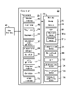
Figure 2 is a more detailed, schematic block diagram 20 in which for clarity
only the
more important operative components of system 10 are shown. System 10 includes
a
controller 22 having a processor 24 and an operating system 26. Instructions
and data
to control operation of processor 24 are stored in a memory 28, which is in
data
communication with processor 24. Typically, system 10 includes both volatile
and non-
volatile memory and more than one of each type of memory, with such memories
being
collectively represented by memory 28.
System 10 has an input/output (I/O) interface 30 for communicating with
peripheral
devices of system 10. Input/output interface 30, the peripheral devices or
both may be
intelligent devices with their own memory for storing associated instructions
and data
for use with the input/output interface 30 or the peripheral devices.
System 10 includes a communications interface in the form of a network card
32.
Network card 32 may be used, for example, to receive project information,
commands
and other data from a central controller, server or database, and to output
results to
that central controller, server or database.
In the embodiment shown in figure 2, system 10 includes a user interface 40
that
includes peripheral devices that communicate with controller 22. These
peripheral
devices comprise the one or more displays 14, keyboard 16, a mouse 42, a
scanner 44
and a printer 46. Additional hardware may be included as part of system 10, or
hardware may be omitted as required for the specific implementation.
Figure 3 shows a block diagram of the main components of memory 28. Memory 28
includes RAM 50, EPROM 52 and a mass storage device 54. RAM 50 typically
temporarily holds program files for execution by processor 24 and related
data.
EPROM 52 may be a boot ROM device and contain system or program code. Mass
storage device 54, which is typically in the form of a hard disk drive, stores
programs,
the integrity of which may be verified and/or authenticated by processor 24
using
protected code from EPROM 52 or elsewhere. In this embodiment, mass storage
device 54 also includes a feedback database 56 (whose content is discussed
below).
CA 02936447 2016-07-11
WO 2015/113109 PCT/AU2015/000045
¨ 9 ¨
It is also possible for the operative components of the system 10 to be
distributed; for
example, input/output devices 12, 14, 42 and 44 may be provided remotely from
controller 22.
Figure 4A is another schematic view of the user interface 40 and controller 22
of figure
3, with more detail shown in controller 22. Specifically, processor 24 of
controller 22
includes a display controller 60 that controls the view that is displayed on
display(s) 14.
Processor 24 also includes a a blueprinter 62 (including a fragmenter 64 and
an
aggregator 66), a geospatial output generator 67, an allocator and releaser 68
(which
has a scheduler 70), a WO (work order) generator 72, a progress monitor 74, a
completer 76 and a WMS interface 78: the functions are these components are
described below. It should be noted that, in some embodiments, the functions
of
allocator and releaser 68 are provided separately in an allocator component
and a
releaser component.
These components of system 10 geospatially optimise the management of the
deployment of both services and materials required to deliver a project. They
do so by
maintaining the geospatial integrity and construction sequence of the design
elements
when carrying out the full lifecycle of the deployment.
Thus, a detailed project design in a spatial data format is provided to system
10 via
network card 32 and stored in memory 28 as design 80, which includes a
description of
all the assets 82 included in the design. Figure 5 is a portion of an
exemplary design
90, in the form of the output of the FOND (trade mark) software of Biarri
Networks Pty
Ltd. In figure 5, land parcels/blocks are shown as shaded polygons. FOND has
generated a telecommunications duct and pit network comprising existing and
new
components. The principal existing components (constituting a duct and pit
network
and/or a pole and aerial network) are shown with lines and small stars.
Exemplary
design 90 also includes:
¨ 12-fibre underground cables (dashed lines 92);
¨ 12-fibre splice joints or Thultiports' for splitting 12-fibre cables into
12 one-
fibre cables (hollow stars 94);
¨ 72-, 144- or 288-fibre splice joints for connecting larger cables to a
number
of 12-fibre cables (circled stars 96);
¨ 72-, 144- or 288-fibre splice joints for connecting pairs of large cables
(lightly
shaded circles 98);
¨ Fibre Distribution Hubs (FDHs) (squares 100), in exemplary design 90 each
adjacent to a lightly shaded circle 98.
CA 02936447 2016-07-11
WO 2015/113109 PCT/AU2015/000045
- 10 ¨
Blueprinter 62 then performs design fragmentation and aggregation, using its
fragmenter 64 and aggregator 66. Fragmenter 64 receives design 80 from memory
28
and extracts assets 82 from design 80, from which fragmenter 64 determines
Work
Items (Wls) 84. The Wls 84 correspond to the items described in, typically, a
Schedule
of Rates (SoR) and Material Supply Agreements (or the like) that are used as
the
contractual frameworks to procure and secure resources to carry out the works
on the
project. Each WI 84 is also given or associated with a geospatial description,
specifying where the respective WI 84 is to be performed, carried out, etc.;
that
description or association is retained throughout the operation of system 10
for the
specific design 80. In addition, each WI 84 is linked to or associated with
any
predecessor Wls, that is, those that must be completed before the instant WI
84. For
example, a cable splicing (i.e. joining cables) WI will require two or more
cable hauling
Wls to be completed beforehand. The WI/predecessor WI relationships are
defined in
an element-to-task matrix 86, discussed below.
The Wls 84 relate both to physical work to be carried out but also generally
imply
certain "Derived Services" that must also be carried out in order to deploy
design 80.
Hence, Wls 84 comprise two types of tasks: explicit tasks 84a, being physical
tasks
explicitly arising from physical tasks implied by specific assets 82, and
derived tasks
84b that arise from the needs of implementing the explicit tasks 84a.
Thus, fragmenter 64 takes each asset 82 (in this example, a network element)
in
design 80 and creates one or more corresponding explicit tasks 84a. For
example, the
presence of an asset 82 in the form of a cable in design 80 prompts fragmenter
64 to
create a cable hauling task 84a. To do this, memory 28 also includes an
element-to-
task matrix 86, which fragmenter 64 searches for assets 82 that it locates in
design 80
and from which it reads the corresponding explicit task or tasks 84a. Indeed,
some
assets 82 in design 80 will imply plural tasks, such as an installation task
and a testing
task.
Such explicit tasks 84a, in the example of a project in which design 80
relates to the
construction of an optical-fibre based telecommunications network (such as
that shown
in figure 5), the explicit tasks 84a may include:
1. CIVIL WORKS
1.1. New Pole Installation
1.2. PVC Pipe Supply & Underground Installation
1.2.1. Open Trenching
1.2.2. Directional Boring
CA 02936447 2016-07-11
WO 2015/113109 PCT/AU2015/000045
-11-
1.3. Pits/Manholes
1.3.1. Pits/Manholes at New Locations in OTR (other than rock)
1.3.2. Pits/Manholes at New Locations in Rock
1.4. Surface Works
1.4.1. Breakout Surface Materials
1.4.2. Reinstatement of Surface Materials
2. CABLE INSTALLATION (UNDERGROUND)
2.1. Pipe Proving
2.2. Pipe Blockages
2.3. Cable Hauling
3. CABLE INSTALLATION (AERIAL)
3.1. Cable Installation Aerial in Power Corridor
3.1.1. Pass Through Pole Installation with =< 10 Degrees Deviation ¨
Tether Cable Types/Multiport Tails
3.1.2. Pass Through Pole Installation with =< 10 Degrees Deviation ¨
Ribbon Cable Types
4. FIBRE JOINT ENCLOSURE INSTALLATIONS AND FIBRE SPLICING
4.1. Joint Enclosures
4.1.1. Installation of Joint Enclosures
4.1.2. Joint Enclosure Cable Preparation
4.2. Fibre Distribution Cabinets (FDH)
4.3. Multiport Installations
4.3.1. Multiport Installations (Underground)
4.4. Splicing
4.5. Fibre Testing
Fragmenter 64 then takes the explicit tasks 84a and generates further "derived
tasks"
84b, each of which fragmenter 64 associates with one or more particular
explicit tasks
84a. The association between an explicit task and a derived task may arise,
for
example, because the explicit task and the derived task must be completed
simultaneously, or because one must precede the other. A single explicit task
may be
associated by fragmenter 64 with one or more derived tasks, and vice versa.
Some
derived tasks are generated by fragmenter 64 based on spatial relationships.
For
example, an explicit task to be performed close to a major road will prompt
fragmenter
64 to generate a derived task in the form of a traffic management task,
associate the
derived task with the explicit task, and tag that derived traffic management
as to be
performed simultaneously with the explicit task.
CA 02936447 2016-07-11
WO 2015/113109 PCT/AU2015/000045
- 12 ¨
Memory 28 includes derived task rules 88, which fragmenter 64 employs to
determine
what derived tasks arise from any particular explicit task and what temporal
relationship tag should be applied to the association created between any pair
of
explicit and derived tasks.
In the same example, the derived tasks 84b may include:
1. APPROVALS
1.1. Land Access and Statutory Approvals
1.2. Utility Infrastructure Access Approvals
2. PROJECT SUPERVISION
2.1. HSE Site Inspection
2.2. Quality Site Inspections
2.2.1. Audit
2.2.2. .. Defects Inspection
2.3. On-boarding and Training
3. COMPLETION ITEMS
3.1. Testing
By this process, fragmenter 64 eventually stores all the required explicit and
derived
tasks 84a, 84b to memory 28.
In addition, allocator and releaser 68 (both discussed further below) samples
explicit
tasks 84a as they are completed and generate derived tasks 84b for quality
assurance.
Table 1 is an example of the output of fragmenter 64, tabulating Network
Element type,
Spatial Reference, Work Item No., Work Item (SoR) Description, Quantity and
Predecessors.
Aggregator 66 logically groups like tasks 84a, 84b into jobs 102 based as
desired on
any one or more of:
i) Collective duration,
ii) Location,
iii) Skill or capability requirements, and
iv) Specific interest.
This allows, for example, allocator and releaser 68 (described below) to
allocate
suitable tasks together for greater efficiency.
CA 02936447 2016-07-11
WO 2015/113109 PCT/AU2015/000045
¨ 13 ¨
Table 1: Exemplary Output of Fraomenter 64
Task Network Spatial Ref Work Work Item (SoR)
Quantity Prede-
ID Element item # Description cessors
001 duct-AB lat/long 7H0B-07-01 Directional 02-02-
02- 50 m None
Boring 01
002 7H0B-07-02 Cable 03-03-01- 50 m
None
Hauling 01
003 duct-BC id?lat/long? 7H0B-07-03 Open
02-02-01- 100 m None
Trenching 01
004 7H0B-07-04 Re- 02-06-02- 30 m2
003
instatement 01
005 7H0B-07-05 Cable 03-03-01- 100 m
003
Hauling 01
006 pit-A id?lat/long? 7H0B-07-06 Pit 02-
03-01- 1 003
Installation 01
007 pit-B id?lat/long? 7H0B-07-07 Pit 02-
03-01- 1 002,003
Installation 02
008 pit-C id?lat/long? 7H0B-07-08 Pit 02-
03-01- 1 001,002
Installation 03
009 jointB id?lat/long? 7H0B-07-09 Joint
06-01-03- 2 005
enclosure 05
cable
preparation
010 jointB id?lat/long? 7H0B-07-10 Joint
06-01-01- 1 009
enclosure 01
installation
011 Splice- id?latilong? 7H0B-07-11 Splicing
06-06-01- 48 010
jointB 03
i) Collective Duration
If aggregator 66 is controlled to base aggregation on task size, aggregator 66
outputs
jobs 102 no greater than the amount of work that a typical work crew for that
task can
complete in a day (or other stipulated work period, as appropriate).
ii) Location
Aggregator 66 provides two levels of aggregation by location, collocation
grouping and
CA 02936447 2016-07-11
WO 2015/113109 PCT/AU2015/000045
¨ 14 ¨
proximity grouping:
¨ Collocation grouping: in some cases, plural assets 82 (such as cables) can
be
installed together (such as into a single duct); in such cases, the explicit
tasks 84a
arising from those assets 82 (e.g. two instances of cable hauling) can be
grouped so
as be performed simultaneously. Blueprinter 62 detects collocatable tasks in
design 80
and groups them into jobs 102, as discussed further below, but with the tasks
so
grouped remaining independent but tagged with a unique job ID that enables any
member of a respective job to be identified.
¨ Proximity grouping: aggregator 66 group tasks into jobs that are physically
close. In the example of a telecommunications network design, aggregator 66
the
network hierarchy defined in design 80 to group such physically close tasks.
The
meaning of "physically close" will depend on the nature of the design, but
will be
apparent to the skilled person and/or implicit in the design 80. Thus, in the
exemplary
design 90, the smallest area in the network architecture is approximately 1
km2 so
aggregator 66 aggregates plural tasks within each cell of that size in design
80.
(Optionally, aggregator 66 may then aggregate any previously unaggregated
tasks by
performing the same process but with a larger grid that, in the
telecommunications
network example, comprises cells of approximately 8 km2.) This approach
employs
cell size as a proxy for travel time between tasks.
If tasks are to be aggregated on the basis of location and size, but jobs
formed by
aggregator 66 according to location aggregation exceed a day's work,
aggregator 66
instead aggregates by location then outputs plural jobs 102 each of no greater
than a
day's size.
iii) Skill or capability requirements
If aggregator 66 is configured to base aggregation on architecture, aggregator
66
identifies tasks 84a, 84b that must be completed as a group before the
commencement of the next activity involving that group. Aggregator 66
aggregates
those tasks into a job (or possibly jobs if size is also to be considered).
iv) Specific interest
Aggregator 66 may be configured to base aggregation on one or more specific
interests. For example, management may want to specifically track every major
joint
splicing activity separately or every single bore activity separately,
regardless of size,
location and architecture. In such cases, aggregator 66 outputs jobs 102 based
on
such tasks that maintain the geospatial information at the task level.
CA 02936447 2016-07-11
WO 2015/113109 PCT/AU2015/000045
¨ 15 ¨
Once jobs 102 have thus been generated by blueprinter 62, blueprinter 62 can
be
controlled to output (via display 14 or printer 46, or in electronic form via
network card
32) any one or more of jobs 102 for inspection, as a spreadsheet detailing all
aspects
of the respective job or jobs. Blueprinter 62 can also be controlled to pass
job data to
geospatial output generator 67, which is configured to convert job data (and
any other
geospatially tagged data generated by system 10) into KML for output (again,
via
display 14 or printer 46, or in electronic form via network card 32) in
geospatial form
suitable for superposition on (or already superimposed on) a map. An example
of the
output of geospatial output generator 67 is shown in figure 11; figure 11
depicts work
order data (rather than job data ) as processed by geospatial output generator
67, but
each work order comprises one or more jobs 102 so the output of geospatial
output
generator 67 will be comparable in those instances.
Blueprinter 62 processes the approved construction design and logically
splits, locates,
sequences and values the labour and materials required by jobs 102 to deploy
design
80, in accordance with Schedule of Rates and Material Supply agreements with
respective contractors. Blueprinter 62 generates and outputs what is termed a
"blueprint", comprising a task dependency graph comprising nodes and
connectors.
Each node represents one of jobs 102 and the connectors connect each task to
its
predecessors/successors. The details of each job 102 include, in this example,
the
relevant network object, location in both spatial coordinates and street
address, task
details, state information (un-allocated, allocated, released, complete),
predecessor
jobs and connection dependency. Connection dependency is a parameter
indicating
the count of all connections (based on one connection per premises to be
connected to
the telecommunications network, though more than one is also possible) that
depend
on the task completion.
Thus, the blueprint is a logically linked representation of all jobs 102
required to
construct the design 80, based on precedence and hierarchy. It does not
include
calculated or assumed durations of the jobs 102, so it does not constitute a
schedule of
work with respect to time. The blueprint does, however, provide the framework
for the
separate determination of a works schedule when resource, progress and
productivity
considerations are applied to it.
Blueprinter 62 stores and maintains the task dependency graph in memory 28 in
the
form of a job dependency matrix 104, which can¨if desired¨be exported to a
.CSV
file in which each row represents a job 102, and each job maintains an index
to the
predecessors.
CA 02936447 2016-07-11
WO 2015/113109 PCT/AU2015/000045
- 16 ¨
Allocator and releaser 68 allocates qualified contractors to the jobs
contained in the
blueprint to push contractors' WMSs to issue orders to labour resources and/or
material suppliers. It should be noted that, herein, the term 'contractor' is
used to refer
to any party that will actually do the work indicated in one or more of the
jobs 102,
though these parties may in some or all cases be individuals or teams,
employees or
otherwise and may not be strictly a 'contractor.'
To facilitate the functions performed by allocator and releaser 68, memory 28
also
includes a task-contractor matrix 106, which includes for each task that may
arise from
implementation of the design 80 a list of one or more approved contractors.
The
effectiveness of allocator and releaser 68 depends on the accuracy and
currency of the
task-contractor matrix 106 with regards to the characteristics of each
contractor
(including relevant capabilities, capacities, productivity, quality and price)
and hence its
fitness to implement a respective job.
Allocator and releaser 68 interfaces via WMS interface 78 with one or more
WMSs that
contain resource data (such as capability, capacity and price per region),
using that
information, filters tasks and contractors by required skill set (e.g.
trenching, cable
hauling, fibre splicing, test), and then considers each set independently.
Allocator and releaser 68 then generates job rankings of jobs 102 based on the
mutual
connection dependency (specified in job dependency matrix 104 for each job
102), the
Area Completion (whereby jobs 102 in areas that are close to completion are
given a
higher ranking), and the contractor dependency (whether the task is blocking a
dependent task which in turn is allocated to a contractor that has exhausted
its ticket
list, to minimize the time that contractors are idle), and hence optimises the
implementation of design 80. To facilitate this process, allocator and
releaser 68
performs this role each day based on data indicating cumulative progress to
close of
business of the respective previous day, this data being received from the
WMSs of
the contractors via WMS interface 78. Whether a job 102 is close to completion
is
determined by allocator and releaser 68 by determining the number of
incomplete
tasks for an Area; allocator and releaser 68 gives an Area with fewer
incomplete tasks
a higher priority and hence ranking.
Allocator and releaser 68 maintains a view of the contractor capacity and then
allocates high ranking tickets to contractors until their capacity is reached
or the set of
tickets is exhausted. High ranking tickets with all predecessors completed are
released. It should be noted that, in allocating a ticket, allocator and
releaser 68
CA 02936447 2016-07-11
WO 2015/113109 PCT/AU2015/000045
- 17 ¨
informs a contractor's WMS, via WMS interface 78, that the contractor has been
given
work that will be released at some time in the future. When releasing a
ticket,
allocator and releaser 68 sends release data to the contractor's WMS, via WMS
interface 78, indicating that the work covered by a previously allocated
ticket must be
completed within a timeframe indicated in that release data. That is,
"releasing" a
ticket involves tagging the ticket as "active" and pushing data to the
respective WMS to
indicate that the tasks covered by that ticket have been activated, allocated
and should
be completed in the stipulated timeframe.
As mentioned above, allocator and releaser 68 uses WMS interface 78 to
exchange
information with external WMSs. WMS interface 78 allows allocator and releaser
68 to
interrogate WMS resource databases of, for example, accredited external
contractors
that¨in due course¨will do the work specified in jobs 102, select such
contractors
based on predefined selection criteria, allocate one or more jobs 102 to such
contractors and then uses WO generator 72 (discussed further below) to
generate
Work Order with corresponding WO numbers for the respective jobs 102.
Allocator and releaser 68 endeavours to fully allocate all jobs relevant to a
defined
component of the design 80. Allocator and releaser 68 also uses relevant
historical (or
globally averaged) contractor productivities to determine both the expected
duration
and approximate timing of each Work Order. In doing so, a future work
commitment to
the contractor is determined.
The allocation criteria employed by allocator and releaser 68 include:
= Accredited WI capability: the contractors that have the necessary confirmed
skillset at the WI level (specified in task-contractor matrix 106).
= Total and Regional Capacity assessment: remaining capacity, based on
total
capacity (of all contractors and plant) versus WOs already allocated.
= Productivity evaluation: using productivities calculated from those jobs
102
completed to date, prioritise contractors with greater productivity.
Productivity
is derived from the average time the respective contractors have taken to
close
like WOs in the WMS (i.e. from activation to completion). Productivity is thus
continually updated by allocator and releaser 68, and stored in contractor-
productivity matrix 108. (In an alternative embodiment, allocator and releaser
68 determines contractor productivity based on like tasks 84a, 84b.)
= Quality Rating: on a quality rating within the WMS resource database.
= Price: at the WI level, and in accordance with the Schedule of Rates of
that
contractor.
CA 02936447 2016-07-11
WO 2015/113109 PCT/AU2015/000045
- 18 ¨
= Pre-commitment: there may be some standing commitments for particular
resources that have already been committed to particular jobs 102 in specific
regions
Thus, allocator and releaser 68 is able to compare the Blueprint Sell price to
the
Allocated buy price at the WI level.
The expected remaining programme duration for the allocated works can then be
calculated based on the total time determined from the productivities of the
contractors
allocated in accordance with job dependency matrix 104. This derived programme
duration can be represented by:
ProjDuration = Blueprint x Resources @ Productivities
If the scope of the required work remains unchanged (i.e. the job dependency
matrix
104 is fixed), the project duration is dependent on contractor numbers and
their
productivities. Allocator and releaser 68 determines the effect of this
dependency, and
allows the programme duration to be controlled by allocating jobs to those
contractors
that have available capacity and by prioritising more productive contractors.
Advantageously, allocator and releaser 68 also determines if there are
insufficient
contractors in a particular region to complete the jobs 102 for that region in
an
acceptable time.
Allocator and releaser 68 also outputs reports on how completely it has been
able to
allocate all remaining jobs 102 to available contractors; the inability of
allocator and
releaser 68 to do so completely indicates a likely contractor shortage at a
potentially
detailed level.
As mentioned above, productivity is treated by allocator and releaser 68 as
the time it
takes to carry out and complete a job once it has been released by the WMS.
The
time to complete a job is a function of the contractors applied to it and
their
productivities. Allocator and releaser 68 uses the capacity of the contractors
and their
(historic) productivities and a predetermined utilisation factor, and packages
the jobs
102 into WOs in accordance with the job dependency matrix 104. The utilisation
factor
is the minimum release commitment that is made with the respective contractor.
For
example, if a contractor has the capacity to deploy ten crews then, with an
agreed
utilisation factor of 70%, allocator and releaser 68 will release enough work
to keep at
least seven crews busy each week (calculated over a week).
CA 02936447 2016-07-11
WO 2015/113109 PCT/AU2015/000045
- 19 ¨
The time windows in which allocator and releaser 68 allocates jobs and
monitors
parameters such as productivities is configurable, and may be selected to
be¨for
example¨daily, weekly or monthly. The finer the timing the more opportunity
for
optimisation. Allocator and releaser 68 also enables the contractors to plan
material
management and inventory with a higher level of certainty.
Allocator and releaser 68 includes a Scheduler (not shown) that allows a user
manually
to enter the effects of problems into the allocation/activation process, such
as unusual
work hours constraints, productivity limitations and the like.
The contractors' WMSs can monitor the progress of WOs including their status
(viz.
open or complete) at sub-item levels. Allocator and releaser 68 can
additionally
monitor progress of the works both logically and geospatially. Allocator and
releaser
68, using job dependency matrix 104 and real-time WO progression at the WI
level,
determines progress at the asset level.
Once WOs have been raised by allocator and releaser 68 (in the allocation
process),
they are converted into active orders by allocator and releaser 68 on a
periodic
(typically daily) basis. This release function of allocator and releaser 68
is, as
discussed above, as follows:
1. allocator and releaser 68 receives updated progress status of WOs at the
level of
jobs 102 from the contractors' WMSs by interfacing via WMS interface 78 with
the
WMSs at regular intervals (e.g. daily, weekly or hourly) and receiving
progress
data.
2. allocator and releaser 68 processes the progress status with its scheduler
70,
which optimises the schedule of all tasks (and subsequently of all remaining
tasks,
at the end of each work period, such as at the end of each day), by ranking
jobs
102 based on progress at the end of each day in accordance with the
optimisation
criteria discussed above. Allocator and releaser 68 then releases for
construction/implementation work orders allocated to the contractors that are
ready
to be deployed based on job dependency matrix 104, allocations, progress to
date,
current priorities, resource information and jeopardy flags.
3. The WMS of the contractor (such as a construction company) is then updated
by
allocator and releaser 68 with the optimised WOs schedule and the relevant WOs
are released by the WMS.
4. On a daily basis, each contractor accesses its WMS to find which new WOs
have
been released by allocator and releaser 68 overnight.
CA 02936447 2016-07-11
WO 2015/113109 PCT/AU2015/000045
¨ 20 ¨
Figure 6 is a schematic representation of the output of scheduler 70, showing
different
types of tasks (e.g. civil works, hauling tasks, splicing tasks and testing
tasks) and their
composition, together with an SDS ("Start & Finish Date") for each task.
The release function of allocator and releaser 68 is expected to minimize
waiting time
and optimise the workflow progress. It also provides a systemic means of
initiating
derived tasks 84b with asset specific precision based on sampling rules and
the like.
For example, QA inspections of 3% of splices can be treated as derived tasks
and
managed with precision, certainty and randomness, based on progress, as an
integral
part of the implementation of design 80.
Additionally, as all tasks 84a, 84b (and hence jobs 102 and W0s) includes
geospatial
information, the effects of geographically specific factors (such as rainfall,
snow,
excessive heat, etc) may be seen in determined productivity, etc, and the
potential
effects of such factors may be taken into account by allocator and releaser
68.
WO generator 72 issues Work Order s(W0s), under the control of allocator and
releaser 68, to a contractor. (W0s are also interchangeably referred to as
Tickets of
Work.) Allocator and releaser 68 controls WO generator 72 to generate a WO by
sending WO generator 72 the requisite Work Order information including the
applicable
Allocated Jobs information. WO generator 72 applies SoR information specific
to the
respective contractor to the Allocated Jobs information received from
allocator and
releaser 68, and issues a suitable WO according to known WMS practices.
Progress monitor 74, via WMS interface 78, uses the WMS(s) of the
contractor(s) to
monitor the progress of the issued WOs at the Job and hence WI or task level.
Through WMS interface 78, daily progress information is be fed back into
allocator and
releaser 68 so that allocator and releaser 68 can operate optimally in its
utilisation of
contractors and its prioritization of jobs 102, in order to optimize the
progress of the
required works.
In some installations the customer may not have a WMS. In these situations the
function of the WMS and WMS interface are replaced by WO generator 72 and
completer 76. Each day the set of assigned tasks produced by WO Generator 72
is
written by WO Generator 72 to a CSV file. This information is forwarded to the
contractors (whether via network card 32, in printed form via printer 46 or
otherwise)
and, at the close of business each day, the contractors provide system 10
(whether on-
line or manually) with details of the Wls that have been completed, which are
tagged
CA 02936447 2016-07-11
WO 2015/113109 PCT/AU2015/000045
¨ 21 ¨
as complete in completer 76.
An alternative processor 24' for system 10 is illustrated schematically in
figure 4B.
Processor 24' is generally identical with processor 24 of figure 4A, and like
reference
numerals have been used to identify like features. However, processor 24'
additionally
includes a variation generator 71 controllable by the user to add, delete and
alter tasks
(including amending the type of a task, the size of a task and geospatial
information
associated with a task). Variation generator 71 is configured to respond to
the
addition, deletion or alteration of a particular task by correspondingly
altering (such as
in sequence and characteristics) any tasks associated with that particular
task. For
example, if a trench (for accommodating one or more cables) that runs down one
side
of a street is to be relocated to the other side of the street, variation
generator 71 may
be controlled to alter the trench so as to be located on the other side of the
street;
variation generator 71 would respond by deleting the trench (from the design)
and
creating one new trench on the opposite side of the street and two new street
crossings to connect the ends of the new trench to the rest of the design.
Alternatively,
in this example but in a more manual approach, variation generator 71 may be
controlled to delete the trench and subsequently to create the new trench on
the
opposite side of the street and the two street crossings. In both cases,
variation
generator 71 would also determine that longer cables would be required and
send data
to the other components of processor 24' to make the required modifications.
Processor 24' includes a jeopardy input 73 for receiving jeopardy data
indicative of one
or more factors that jeopardize the ability of a specific task to be
commenced, thereby
identifying geospatially tasks for consideration by scheduler 70. This enables
the
geospatial data handling ability of system 10 to integrate delays at the task
level in the
scheduling of the work.
Processor 24' also includes a defect rectifier 75 that is configured to
receive defect
identification data indicative of a defect in a specified asset 82, to
identify which
resource performed work on the specific asset using the geospatial data held
by
system 10, and to control work order generator 72 to generate one or more
geospatially tagged defect rectification tasks 84a, 84b adapted to remediate
or correct
the defect.
This allows system 10 to automatically allocate and release the one or more
defect
rectification tasks to the appropriate resource, typically the resource that
carried out the
work in which the defect occurred.
CA 02936447 2016-07-11
WO 2015/113109 PCT/AU2015/000045
¨ 22 ¨
In summary, therefore, the process implemented by system 10 includes¨as shown
in
flow diagram 120 of figure 7¨at step 122 fragmenter 64 (of blueprinter 62)
fragmenting
design 80 into Wls 84 At step 124, aggregator 66 (of blueprinter 62) logically
grouping
like tasks 84a, 84b into jobs 102, while at step 126 blueprinter 62 maps the
labour and
materials required by jobs 102 to deploy design 80 and generates job
dependency
matrix 104.
At step 128, allocator and releaser 68 allocates and releases jobs (in groups
of one or
more), and at step 130 allocator and releaser 68 controls WO generator 72 to
generate
and issue Work Orders. At step 132, progress monitor 74 monitors progress and
updates the relevant data. At step 134, system 10 periodically checks (such as
once a
day) whether the project has been completed; if not, processing returns to
step 128
and continues, though now with updated data concerning jobs or tasks
remaining,
contractor productivity, etc. If, at step 134, system 10 determines that e
project has
been completed, processing continues at step 136 where system 10 generate and
outputs documentation that documents the project as-built. Processing then
ends.
System 10, as has been discussed above, includes a WMS interface 78 so that it
can
work with existing WMSs of outside parties. Figure 8 is a simplified
illustration of
system 10 and its typical interaction, when in use, with outside entities such
as
contractors' WMSs 140, a materials management system 142 and field services &
audit management systems 144. Figure 8 also depicts the principal input to
system 10
(the detailed design 80) and 'as-built' documentation 146.
Figure 9 is a schematic data flow diagram 150 for the operation of system 10
and its
interaction with customers and contractors (via W0s). As indicated, the
geospatial
integrity at the task and item level is maintained end-to-end.
Figure 10 is an example 160 of detailed work order data outputted by system 10
(in the
form of job dependency matrix 104 outputted as a .CSV file), for the example
of a
design 80 comprising a telecommunications network. Figure 11 shows the
corresponding geospatial work order data (comprising one or more jobs 102)
outputted
by geospatial output generator 67 of system 10 in KML, superimposed on an
aerial
photograph of the area in which those WOs are to be implemented.
Thus, this embodiment addresses¨at least to some extent¨problems such as:
= Lack of automation of the conversion of the design documents into
spatially
referenced work tasks leading to inconsistent and inefficient flow of work to
the
CA 02936447 2016-07-11
WO 2015/113109 PCT/AU2015/000045
¨ 23 ¨
field resources.
= Excessive highly manual tasks and interfaces and reliance on existing non-
geospatial processes.
= Resultant unsustainably low levels of workforce productivity and
profitability.
= Inability to determine detailed workforce planning against task based
workload.
= Resultant lack of willingness of Delivery Partners to invest in
recruitment and
training of the required workforce.
It should be understood to those persons skilled in the art of the invention
that many
modifications may be made without departing from the spirit and scope of the
invention. It should also be understood that the reference to any prior art in
this
specification is not, and should not be taken as an acknowledgement or any
form of
suggestion that such prior art forms part of the common general knowledge in
any
country.
In the claims which follow and in the preceding description of the invention,
except
where the context requires otherwise due to express language or necessary
implication, the word "comprise" or variations such as "comprises" or
"comprising" is
used in an inclusive sense, i.e. to specify the presence of the stated
features but not to
preclude the presence or addition of further features in various embodiments
of the
invention.