Note: Descriptions are shown in the official language in which they were submitted.
CA 02936491 2016-07-11
1
Mine vehicle and method of determining position and direction
of monitored object
Background of the invention
The invention relates to a mine vehicle, which is provided with a
scanning device for scanning surroundings of the mine vehicle in order to pro-
duce point cloud data in a machine coordinate system.
The invention further relates to a method of and a control unit for de-
termining position and direction of a monitored object of a mine vehicle.
The field of the invention is defined more specifically in the inde-
pendent claims.
Mine vehicles are used in underground and surface mines, con-
struction sites and at other work sites. The mine vehicle may be provided with
one or more mine work devices for performing determined mine work tasks at
the work sites. The mine vehicle may be a rock drilling rig or a loader, for
ex-
ample. Positioning of the mine work devices may require use of extensive and
complicated position systems. The known solutions have shown to contain
some disadvantages.
Brief description of the invention
An object of the invention is to provide a novel and improved mine
vehicle and method for determining position and direction of a monitored
object
of the mine vehicle.
The mine vehicle according to the invention is characterized by the
features of independent apparatus claim.
The control unit according to the invention is characterized by the
features of a further independent apparatus claim.
The method according to the invention is characterized by the fea-
tures of independent method claim.
An idea of the disclosed solution is that the mine vehicle is provided
with one or more scanning devices for scanning surroundings of the mine ve-
hide. The mine vehicle is further provided with at least one boom and at least
one mine work device at a distal end portion of the boom. Position and orienta-
tion of one or more object of the mine vehicle is monitored in a machine coor-
dinate system of the mine vehicle. The monitored object is located inside a
reach area of the scanning device whereby operational scanning data compris-
ing point cloud data is produced of the monitored object. The scanning data is
CA 02936491 2016-07-11
2
input to at least one control unit capable to process the point cloud data.
The
point cloud data comprises data on coordinates for the points detected by the
scanning. The control unit is provided with reference data on the monitored
object whereby the control unit may compare the scanned data to the refer-
ence data. The control unit may then search the monitored object from the
produced point cloud data and may determine coordinates for the found points
in the machine coordinate system. On the basis of the coordinates of the
points defining the searched object, the control unit may determine position
and direction of the monitored object. The mine work device or at least one
part of the Mine work device may be determined to be the monitored object
whereby the control unit may be configured to determine position and direction
of the at least part of the mine work device in the machine coordinate system.
The control unit may be provided with one or more processors for executing
one or more point cloud processing programs and/or searching algorithms in
order to perform the disclosed procedures.
An advantage of the disclosed solution is that the position and direc-
tion determination of the monitored object of the mine vehicle may be carried
out without .a need for extensive measuring equipment. An additional ad-
vantage is that the disclosed solution is suitable for any type of mine
vehicles
and does not require any modifications to their basic structures. Further, the
solution may provide improvements to accuracy of the position and direction
determination. A feasible further advantage is that the disclosed solution may
obtain a strong statistical certainty for the produced results because
repeating
the scanning and analyzing processes is easy and fast. The detected position
and direction data of the monitored object may be used for whatever purposes.
According to an embodiment, the control unit is provided with refer-
ence data comprising a design point cloud data of the monitored object, which
is converted from a 3D design data of monitored object of the mine vehicle.
The monitored object is inside a reach area of the scanning device and is
thereby recorded in the produced operational point cloud data. The control
unit
is configured to execute the point cloud processing program for comparing the
design point cloud data with the operational scanning data in order to detect
the monitored object in the operational point cloud data and to determine posi-
tion and direction of the monitored object in the machine coordinate system.
According to an embodiment, the control unit may determine coor-
dinates of any point of the design point cloud data, including also points,
which
CA 02936491 2016-07-11
3
are non-visible in the scanned operational point cloud data. This embodiment
allows choosing one or more points inside the monitored object and defining
coordinates of the chosen points. This way, any point defining the monitored
object may be chosen as a target to monitoring, and not only points which are
located on the visible outer surface.
According to an embodiment, shape of the one or more monitored
object in the machine coordinate system is input to the control unit. The
control
unit is configured to examine the operational point cloud data in order to
find a
point cloud pattern matching with the input shape of the at least one
monitored
object. Further, the control unit is configured to determine position and
orienta-
tion of the detected one or more monitored object.
According to an embodiment, shape of the one or more monitored
object in the machine coordinate system is input to the control unit. Point
cloud
data of the shape of the monitored object may be produced by initial scanning
of the monitored object. The produced point cloud data may be utilized as ref-
erence point cloud data for searching the monitored object. The initial
scanning
is easy and fast to execute and may be done anywhere. Another advantage is
that no additional data of the monitored object is required.
According to an embodiment, the monitored object is provided with
at least one supplementary identifier or marker in order to facilitate the
search-
ing and position detection processes. Surface shape of the identifier may have
a predetermined configuration and the control unit is provided with data on
the
shape of the identifier. Execution of the point cloud processing program in
the
control unit is configured to search and detect the shape of the identifier
from
the scanned point cloud data whereby the monitored object is recognized by
means of the initial point cloud data of the identifier. The supplementary
identi-
fier may be arranged to a basic structure of the mine vehicle or a mine work
device of the mine vehicle. The supplementary identifier does not have any
use for the normal operation of the mine vehicle, such as drilling, bolting,
load-
ing etc.
According to an embodiment, the mine vehicle or the mine work de-
vice is provided with one or more supplementary identifiers comprising spheri-
cal or curved surfaces. The spherical surface creates a special point pattern
in
the scanning data and is therefore easy to search and detect. The control unit
may comprise a searching algorithm for examining the scanning data and find-
ing the predetermined point patterns.
CA 02936491 2016-07-11
4
According to an embodiment, the supplementary reference object
arranged to the mining vehicle has predetermined two-dimensional configura-
tion. An outer rim of the supplementary reference object may be a square, a
circle, or any other form which deviates clearly from shapes of the structural
components of the mine vehicle. The shape of the supplementary reference
object is input to the control unit and is thereby easy to search and detect
in
the scanning data. The control unit may comprise a searching algorithm for
examining the scanning data and finding predetermined point patterns.
According to an embodiment, the mine vehicle comprises one or
more booms. The boom may comprise a fastening portion for providing the
boom with a mine work device, measuring device or tool.
According to an embodiment, the mine work device may be provid-
ed with one or more tools, whereby the tool may serve as the monitored object.
The tool may be a drilling tool comprising a drill bit, for example.
According to an embodiment, the mine vehicle comprises a feed
beam and a rock drilling machine supported on the feed beam. The control unit
is configured to determine position and direction of the feed beam, and is con-
figured to record the determined data as drill hole position and direction
data
when the feed beam is positioned at the drill hole. In this embodiment the
feed
beam is the monitored object. Alternatively, the monitored object may be the
rock drilling machine or a drilling tool connected to the rock drilling
machine.
The mine vehicle provided with the rock drilling machine may be a rock
drilling
rig or bolting rig.
According to an embodiment, the mine vehicle comprises a bucket
or shovel serving as a mine work device. The bucket and shovel may be ar-
ranged to a boom and may be determined to be the monitored object. The dis-
closed solution may be arranged to search the bucket or shovel and determine
position and orientation of the bucket, shovel or distal end of the boom, or
any
other portion of the boom. The mine vehicle may be a wheel loader or an ex-
cavator, for example.
According to an embodiment, the mine work device may be a rock
breaking hammer arranged at a distal end portion of a boom. The breaking
hammer may be the monitored object.
According to an embodiment, the mine vehicle comprises one or
more of the following mine work devices: a charging device, feeding device,
CA 02936491 2016-07-11
injection device or shotcreting device. The mine work device may be searched
and the position and orientation may be determined.
According to an embodiment, the mine vehicle comprises a loading
platform or corresponding load carrying space serving as a mine work device.
5 The load carrying platform may be the monitored object.
According to an embodiment, the mine vehicle comprises a man
cage arranged at a distal end of a boom. The man cage may serve as a mine
work device and may be the monitored object.
According to an embodiment, the mine vehicle comprises at least
one boom provided with at least one mine work device. The scanning device
and the control unit are serving as a boom position measuring arrangement for
detecting position and orientation of the mine work device.
According to an embodiment, the boom is without any physical
boom or joint position sensor. Instead of boom sensors, the scanning device
and the control unit are serving as a boom position measuring arrangement for
detecting position and orientation of the mine work device. Thanks to this em-
bodiment, the structure may be more robust since there is no electronics in
critical areas of the boom. Furthermore, joints of the boom may be designed to
be more robust since no space for sensors needs to be designed in. An addi-
tional advance may that joint clearances and boom deflection have no effect
on measurement accuracy. Moreover, since no sensors are used, there is no
need for calibration measurements of the sensors.
According to an embodiment, the mine vehicle comprises at least
one mine work device. The scanning device and the control unit are serving as
a position measuring arrangement for detecting position and orientation of the
mine work device, whereby no need for any additional measuring devices or
sensors exists. Thus, the positioning system may be simple.
According to an embodiment, the mine vehicle comprises at least
one boom provided with at least one mine work device. The boom is instru-
mented and comprises one or more boom or joint position sensors or measur-
ing devices. The disclosed solution may be utilized for calibrating the
sensors.
This embodiment allows the sensors or measuring devices to be calibrated
after maintenance or when new sensors are installed, for example.
According to an embodiment, the mine vehicle comprises at least
one boom provided with at least one mine work device. The boom is instru-
mented and comprises one or more boom or joint position sensors or measur-
-
CA 02936491 2016-07-11
6
ing devices for determining the position of the boom. The disclosed solution
comprising scanning, searching and point cloud processing is used for deter-
mining the position and direction of the mine work device at a desired first
posi-
tion, or initial/reference position, where after the boom is moved to a
desired
-- location and the new position is determined by means of the sensors or meas-
uring devices of the boom. Thus, the position of the monitored object may be
determined by using scanning technique when the scanning device has good
visibility to the monitored object, and when the monitored object is moved so
that the visibility is poor then the conventional measuring means of the boom
-- may be utilized.
According to an embodiment, the mine vehicle comprises at least
two scanning devices located at a distance from each other so that the scan-
ning devices have different coverage and range. The use of several scanning
devices may increase detection coverage of the scanning, whereby the scan-
-- ners may find the monitored object more securely. Alternatively, one or
more
scanning devices may be arranged movably so that they may be moved to
suitable locations if visibility of the monitored object is poor and the
search of
the monitored object is not successful.
According to an embodiment, the mine vehicle is provided with a
scanning mOdule. The scanning module comprises a frame and mounting
means for fastening the frame to the mine vehicle detachably. Thus, the scan-
ning module is readily mountable to any mine vehicle. The scanning module
further comprises at least one scanning device and at least one control unit
for
processing the scanned data. The scanning module may also be provided with
-- at least one data communication device allowing data communication between
the scanning module and at least one control device external to the scanning
module. The control unit of the scanning module may process the scanned
data and may provide a control unit of the mine vehicle with the position and
direction information. Thereby the control unit of the mine vehicle needs not
-- necessarily be equipped with point cloud processing and searching programs,
for example.
According to an embodiment, the control unit is provided with data
on position and direction of the at least one scanning device in the machine
coordinate system. Thus, in this embodiment the scanning device is positioned
-- accurately to a pre-determined position, the location of which is input to
the
control device. The scanning device may have a specific place on a carrier,
CA 02936491 2016-07-11
7
whereby coordinates of the position are known in the machine coordinate sys-
tem of the mine vehicle.
According to an embodiment, the position of the scanning device is
not pre-determined, but is instead determined by utilizing scanning and point
cloud matching. The control unit may be provided with a detection procedure
for detecting position and direction of the scanning device in the machine co-
ordinate system. The control unit may also be provided with a point cloud
matching program allowed to be executed in the processor. The mine vehicle
comprises at least one reference object, which is searched by scanning. An
initial first point cloud data is input to the control unit. The first point
cloud data
comprises stored reference model of the mine in a mine coordinate system. At
least one second point cloud data is produced by the scanning device of the
mine vehicle and is input to the control unit. The second point cloud data com-
prises operational scanning data of the current position of the mining
vehicle.
The control unit executes the point cloud matching program in order to match
the operational second point cloud data to the reference first point cloud
data
and determines position and direction of the scanning device in the mine coor-
dinate system on the basis of the determined matching between the operation-
al point cloud data and the reference cloud data. Thereafter, the control unit
executes a coordinate transformation process to determine the position of the
scanning device in the machine coordinate system on the basis of the position
and direction of the scanning device in the mine coordinate system. Thanks to
this embodiment, the scanning device or scanning module may be mounted at
any location. on the mine vehicle and still the accurate location of the
device
may be determined.
According to an embodiment, the monitored object is arranged in
connection with a structural element being connected to the carrier by means
of at least one joint. Then the monitored object is movable relative to the
carri-
er. The monitored object may be located at the distal end portion of a boom.
The control unit may be provided with kinematic data on the movable structural
element for determining possible movement paths of the monitored object. The
kinematic data may be utilized in collision prevention measures, for example.
Furthermore, based on the kinematic data additional information may be pro-
vided for the operator.
According to an embodiment, the control unit is provided with data
on position and orientation of the mine vehicle in a mine coordinate system.
CA 02936491 2016-07-11
8
The position of the mine vehicle may be determined by utilizing scanning posi-
tioning techniques, on-board position measuring devices, satellite positioning
signals or fixed positioning infrastructure such as positioning markers, for
ex-
ample. The control unit is configured to execute a coordinate transformation
process to determine the position and direction of the monitored object in the
mine coordinate system on the basis of the detected position and direction of
the monitored object in the machine coordinate system. Thanks to this embod-
iment, it is possible to record positions of drill holes and rock bolts in the
mine
coordinate system, visualize the locations on a display device and create
needed mine documents, for example. Further, when the monitored object is
located at the distal end of the boom, it is possible to use the disclosed
solution
for surveying surfaces locating at a reach of the boom.
According to an embodiment, the mine vehicle comprises one or
more on-board control units for executing the disclosed measures and proce-
dures. Thereby, the on-board control unit is configured to execute the point
cloud processing program for searching and detecting the monitored object in
the point cloud data, and based on that, to determine position and direction
of
the monitored object. In this embodiment the mine vehicle is provided with all
the needed resources to gather the needed data and to process it on-board.
According to an embodiment, the mine vehicle is provided with a
scanning module comprising a first control unit being in operational communi-
cation with a second on-board control unit arranged to control actuators and
devices of the mine vehicle. The second control unit is provided with the
searching and point cloud processing programs and algorithms.
According to an embodiment, the mine vehicle is in operational
communication with one or more control units external to the mine vehicle. The
at least one external control unit is configured to execute the disclosed
measures and procedures. The control unit may comprise one or more com-
puters or control units external to the mine vehicle. The control unit
external to
the mine vehicle is configured to execute the point cloud processing program
for searching and detecting the monitored object in the point cloud data and
to
determine position and direction of the monitored object. The external control
unit may communicate with the mine vehicle via data communication. In this
embodiment the external control unit may be provided with the needed data
processing capacity.
CA 02936491 2016-07-11
9
According to an embodiment, the mine vehicle comprises at least
one on-board control unit and at least one data communication device allowing
data communication between the on-board control unit and one or more con-
trol units external to the mine vehicle. The data communication may be based
on any wireless data transfer technique. The mine or work site may be provid-
ed with a wireless network utilizing radio wave signals.
According to an embodiment, the reference data on the monitored
object of the mine vehicle may be downloaded to the on-board control unit at
suitable instances and may be stored in an on-board storage media.
According to an embodiment, the scanning is repeated two or more
times for detecting the monitored object. The scanning may take such a short
time that scanning does not cause problems to the basic operation of the mine
vehicle. This embodiment may further improve accuracy of the position and
direction determination.
According to an embodiment, the scanning device is directed to-
wards the monitored object, or is positioned and directed at least so that the
monitored object is inside a scanning area of the scanning device. Thus, the
scanning device may be arranged to scan at least operational areas of one or
more booms.
According to an embodiment, the scanning device may comprise a
2D scanning unit, a rotating frame, a rotating device and a fastening unit.
The
2D scanning unit is mounted to the rotating frame, which may be a shaft, a ro-
tating table or any other support structure, which is rotatable and may be
rotat-
ed by means of the rotating device. Thus, the 2D scanning unit is arranged to
be rotated 3600 degrees around a rotating axis of the rotating frame. The fas-
tening unit allows fastening of the scanning device to the mine vehicle.
According to an embodiment, the scanning device may comprise a
3D scanning unit capable of producing scanning data 360 degrees around
itself. In this embodiment the scanning device may be without any separate
rotating means for rotating the scanning unit.
According to an embodiment, the scanning unit is a laser scanner.
According to an embodiment, the scanning unit comprises at least
one camera. The scanning device may be based on stereo vision system
comprising at least two cameras. Alternatively, the scanning may be based on
a technology known as a depth from focus ¨system, wherein one camera is
used and the method basically works by taking a focus stack of an object, and
=.
CA 02936491 2016-07-11
then analyzing the luminance of each pixel in relation to its neighbors. The
control unit may be provided with image processing system for processing data
received from the one or more cameras.
=
According to an embodiment, the scanning device comprises in ad-
5 dition to the
scanning unit at least one camera for recording color information
of the scanned obstacles. The recorded color information may be connected to
the scanned point cloud data. This way additional information may be gath-
ered. The monitored object may be provided with a special color differing from
the other objects and surrounding in order to facilitate the searching and
posi-
10 tion detection processes.
According to an embodiment, the 3D scanning data is obtained by
round trip time of flight of a laser that is swept across measured surface or
ob-
ject. This type of remote sensing technique is also known as LiDAR (Light De-
tection And Ranging).
According to an embodiment, the 3D scanning data is obtained by
round trip time of flight of single (modulated) light source and the return
times
of reflections from different parts of the measured surface or object. This
type
of remote sensing technique is also known as ToF (Time of Flight). In this em-
bodiment ToF -cameras may be used.
According to an embodiment, the 3D scanning data is obtained by
geometry of a known pattern of light projected to the measured surface or ob-
ject shown in one or more camera images. This type of 3D scanning is also
known as a structured light 3D scanning technique.
According to an embodiment, the 3D scanning data is obtained by
analysis of multiple pictures taken of same target from different points of
view.
In this embodiment a stereo camera system may be exploited. The control unit
may be provided with an image processing system for processing image data
received from the two or more cameras.
According to an embodiment, the scanning device or module is ar-
ranged movably. Thus, the scanning device has one or more operable posi-
tions for executing the scanning and possibly an idle position. The fastening
unit of the scanning device or module may comprise at least one transfer de-
vice for moving the scanning device. The transfer device is configured to move
the scanning device between the operable positions and to the idle position.
According to an embodiment, the scanning device comprises a pro-
tective housing or shield for covering at least the scanner. The protective
hous-
.
CA 02936491 2016-07-11
11
ing may protect the scanning device against impurities, moisture, falling mate-
rial and impacts. The protective housing may provide shield to the scanning
device or at least to the scanning unit continuously or, alternatively only
when
not in use.
According to an embodiment, the scanning device is movable and
comprises at least one operable position and an idle position. The idle
position
is located inside a protective housing. The protective housing may protect the
scanning device against impurities, moisture, falling material and impacts.
According to an embodiment, the mine vehicle is intended to be op-
erated in an underground mine. The underground mine comprises an under-
ground rock space or rock cavity, such as a tunnel, or a storage hall.
According to an embodiment, the mine vehicle is intended to be op-
erated in a surface mine. The surface mine may be an opencast mine, for ex-
ample. However, the disclosed solutions are also suitable to be utilized in
any
other work sites, such as in road, railway and building construction sites.
According to an embodiment, a control unit for determining position
and direction of at least one monitored object of a mine vehicle comprises
connection means for being in operational communication with the mine vehi-
cle comprising at least one scanning device, receiving means for receiving
from the mine vehicle operational scanning data comprising point cloud data,
processing means for processing the received operational scanning data; and
the control unit is provided with input reference data on at least one
monitored
object in a machine coordinate system, with at least one point cloud pro-
cessing program allowed to be executed in the processing means; and the
control unit is configured to execute the point cloud processing program for
comparing the reference data with operational scanning data received from the
mine vehicle in order to search and detect the at least one monitored object
in
the point cloud data and to determine position and direction of the at least
one
monitored object in the machine coordinate system on the basis of coordinates
provided in the point cloud data.
One or more of the solutions disclosed in this application and relay-
ing on the scanning technique and point cloud matching process may have the
following advantages:
No need for sensors in the boom.
CA 02936491 2016-07-11
12
=
- More robust structure since no electronics or sensors in critical are-
as of the boom.
- Joints of the boom may be designed to be more robust since no
space for sensors needs to be designed in.
No need for calibration of joints of the boom in production or after
sensor maintenance.
Joint clearances and boom deflection have no effect on measure-
ment 'accuracy when the position detection is based on scanning tech-
nique.
More accurate boom position measurements by the scanning tech-
nique. Positioning accuracy may be +1- 1mm when scanning is utilized.
The scanning technique may also be used together with the con-
ventional joint measurement techniques. Then some of the joint sensors
may be removed. Alternatively, the positioning detection may utilize
combination of the conventional measurements and the scanning tech-
niques.
- Utilization of the scanning system does not require any special skills
for the operators. The process may be completely automated, if so de-
sired.
The system does not need any fixed infrastructure to support posi-
tion measurement.
- Measuring utilizing the scanning is fast and may be repeated sever-
al times, if need be.
- The disclosed solution provides all six degrees of freedom for the
position of the monitored object or part of the mine vehicle in the coordi-
nate system of the mine vehicle. In a rock drilling rig the degrees of
freedom may be: X, Y and Z coordinates, tilt, roll and yaw angles.
- The system may also provide a 3D scan of the entire surroundings
of the mine vehicle.
The positioning system may be connected to fleet management sys-
tems for providing data on mine vehicles in the mine.
- The system may allow removal of all sensors in a boom of a rock
drilling rig and may still give accurate position and angle information for
drilled holes or installed bolts. The system may also avoid a need for
any compensation model needed for deflection etc.
=
CA 02936491 2016-07-11
13
- The system may be applied in mine vehicles designed for under-
ground mines, surface mines and any other work sites.
- Investment costs may be low, since the mine vehicle needs to be
equipped only with a scanning device and a calculation PC. The scan-
ning device, processing means and data transmission unit may be ar-
ranged to form a scanning module, which may be readily mounted to
any mine vehicle.
The same equipment comprising the scanning device, point cloud
matching program and control unit may be utilized in navigation, position de-
tection of the mine work device and drill holes, mine surveying, collision pre-
vention and also for providing desired information for mine control and fleet
management systems.
The detailed embodiments which are disclosed in connection to the
mine vehicle also relate to the method, and vice versa.
The above-disclosed embodiments can be combined to form suita-
ble solutions provided with necessary features disclosed.
Brief description of the figures
SOme embodiments are described in more detail in the accompany-
ing drawings, in which
Figure 1 is a side view of a rock drilling rig provided with a drilling
unit and scanning means for determining position of the drilling unit,
Figure 2 shows schematically a principle of scanning surroundings
of a mining vehicle,
Figure 3 is a schematic side view of a scanning device arranged on
a carrier of a mining vehicle and being able to be moved,
Figure 4 is a schematic view of a basic principle of point cloud
matching,
Figure 5 is a schematic diagram showing basic features of the dis-
closed solution,
Figure 6 is a schematic diagram showing feasible reference data on
the monitored object,
Figure 7 is a schematic view of a control block or diagram showing
related elements, control means and features of the disclosed solution, and
CA 02936491 2016-07-11
14
Figure 8 is a schematic diagram showing feasible monitored objects
of a mine vehicle.
For the sake of clarity, the figures show some embodiments of the
disclosed solution in a simplified manner. In the figures, like reference
numer-
als identify like elements.
Detailed description of some embodiments
Figure 1 shows a rock drilling rig 1 as an example of a mine vehicle.
Also rock bolting rigs, charging rigs, measuring vehicles and transport and
loading vehicles are mine vehicles. Thus, the mine vehicles may be provided
with mine work devices such as rock drilling units, bolting units, charging
units,
loading units and load carrying units. Further, excavators provided with mine
work devices, such as breaking hammers, may be considered to be mine vehi-
cles. The disclosed method and solution may be applied in all type mine vehi-
cles.
The rock drilling rig 1 may comprise a movable carrier 2 and one or
more booms. 3 connected to the carrier 2. At a distal end portion of the boom
3
may be a drilling unit 4. The drilling unit 4 may comprise a feed beam 5 and a
rock drilling machine 6 supported on it. The rock drilling machine 6 may com-
prise a shank at a front end of the rock drilling machine 6 for connecting a
tool
7. At least one boom 3 may comprise a mine work device other than the drilling
unit. Thus, the mine work device may be a rock bolting unit or a charging
unit,
for example. The mine work device, such as the drilling machine, the feed
beam, or the tool may be the monitored object the position and direction of
which is determined according to the principles disclosed above.
In Figure 1 the rock drilling rig 1 is operating in an underground
mine space 8, which may be a tunnel, storage hall or corridor, for example.
The mine space 8 may comprise a face surface 9, wall surfaces 10 and a roof
surface 11. The rock drilling rig 1 is provided with one or more scanning de-
vices S for measuring surroundings of the rock drilling rig 1. The scanning de-
vice S may scan 3600 and may thus measure the surrounding surfaces and
other obstacles around the rock drilling rig 1 and produce scanning data for
the
system. Alternatively, the scanning device S may scan only operational area of
the boom and the drilling unit, and may then have a limited scanning area. The
scanning device S may comprise a laser scanner, a camera or any other de-
vice capable of producing point cloud data. The scanning device S may be
placed on the carrier 2.
CA 02936491 2016-07-11
The scanning device S may be placed in a known position on the
mine vehicle. Then coordinates of the scanning device are known in machine
coordinates system 12 of the mine vehicle. The scanning device sees around
and detects also one or more monitored objects, parts or components of the
5 mine vehicle. as well.
Alternatively, the position of the scanning device S need not be ac-
curately predetermined and calibrated when the disclosed system utilizes point
cloud matching techniques. Then, at least one reference component or object
of the rock drilling rig is detected in the scanning data and produced point
10 cloud data of the detected object is utilized in determination of
relative position
of the scanning device S on the carrier 2.
The rock drilling rig 1 has a machine coordinate system 12 and the
mine has a mine coordinate system 13. On-board the rock drilling rig 1 may be
one or more control units 14a for receiving scanning data, performing point
15 cloud matching and searching measures, producing position data and execut-
ing needed coordinate transformations according to principles disclosed in
this
patent application.
As already mentioned, in Figure 1 the monitored object MO may be
the drilling unit 4. Alternatively, distal end or any other part of the boom 3
may
be selected to be the monitored object.
The scanning device S may be part of a scanning module SM com-
prising a frame 30 provided with mounting means, and a control unit 14b pro-
vided with a processor and needed programs for executing the above dis-
cussed search and position determination procedures.
The boom 3 may be without any sensors since the needed position
and direction data may be produced by the scanning. However, the boom 3
and the mine work device may also comprise conventional sensors or measur-
ing means 31 for position and direction determination in addition to the scan-
ning means: The scanning and measuring means may be used together for
example in situations when the scanning range does not cover all possible
boom positions.
Figure 1 further discloses that the mine vehicle 1 may communicate
with one or more external control units 14c, which may be part of a mine con-
trol system or they may be individual computers, servers or terminal devices.
Figure 2 shows scanning of surfaces of a mine space 8 surrounding
a mining vehicle 1. Thus, point cloud data 15 may be produced of wall surfaces
CA 02936491 2016-07-11
16
10a, 10b and a roof surface 11. As it is disclosed in the simplified Figure 2
with
enlargements, the surfaces of the wall surfaces 10a, 10b and the roof surface
11 have individual shapes since the rock material is detached by blasting. To-
pography of the surfaces may be considered to be a kind of finger print of the
mine.
Figure 2 also discloses that by means of the scanning, a monitored
object MO may also be detected and a point cloud may be produced. The point
cloud data of the monitored object MO comprises points, which are character-
istic for the monitored object. Based on the shape the points create, the moni-
tored object MO may be recognized in a searching step of the scanning proce-
dure. The control unit 14a may then determine coordinates for the recognized
points defining the monitored object in the point cloud and may determine posi-
tion and direction of the monitored object in the machine coordinate system
12.
The control unit 14a may transform the position and direction data of the moni-
tored object MO into coordinates of the mine coordinate system 13 when the
location of the mine vehicle is known. The position of the mine vehicle in the
mine or work site may be determined by means of the scanning techniques or
by means of conventional measuring means.
In Figure 2, as well as in Figure 4, it is illustrated by black dots 17
points where a ray of a scanning device S meets a physical target and causes
detection. The point cloud data 15 comprises several points 17 created by the
scanning. The points 17 are shown as black dots. It can be considered that the
point cloud data represents information of what the scanning sees. Every point
17 has coordinates x, y and z in machine coordinate system 12, whereby posi-
tion and direction of the monitored object MO may be determined relative to
the scanning device S in the machine coordinate system 12. The monitored
object MO may be found from the point cloud data on the basis of reference
data input to the control unit 14.
In Figure 3 a scanning device S is arranged on a carrier 2 of a min-
ing vehicle 1. The scanning device S may comprises a protective housing 18
for protecting the scanning device S against impurities, moisture and impacts.
The scanning device S and the protective housing 18 may be moved relative to
each other. The scanning device may have one or more operable positions 19
for executing the scanning and an idle position 20 where it is protected by
the
protective housing 18. The scanning device S may also be moved in situations
when visibility to the monitored object is prevented or is poor. Further, the
CA 02936491 2016-07-11
17
scanning device S or scanning module may comprise fast coupling means
whereby it can be easily mounted to the mine vehicle 1.
Figure 4 discloses a basic principle of determining position and ori-
entation of a mine vehicle 1 by means of scanning and point cloud matching. A
surrounding of the mine vehicle 1' is scanned and a second point cloud data 21
is produced. An initial first point cloud data 22 may be created beforehand
and
it may be stored to a control unit 14a on-board the mine vehicle 1 or to an ex-
ternal control unit 14c. The control unit 14a, 14c may be provided with a proc-
essor and a point cloud matching program or algorithm for matching the sec-
ond point cloud data 21 to the first point cloud data 22. Thus, the first
point
cloud data 22 serves as a reference point cloud data and the second point
'cloud data 21 serves as an operational point cloud data. In Figure 4 the
match
23 is shown in a strongly simplified manner. On the basis of the match 23, the
control unit 14a or 14b may determine position and orientation of the mine ve-
hide 1 in a mine coordinate system 13. Every point 17 of the point cloud data
has x-, y-, and z- coordinates. In the simplified example of Figure 4, the
second
point cloud data 21 fits completely to the reference point cloud data 22.
The above mentioned principles of point cloud matching analysis
and best fit procedures of point clouds may be utilized also for searching and
detecting position and direction of a monitored object. During pattern
matching
the system searches the monitored object and calculates position data for it.
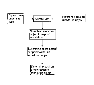
Figure 5 shows basic steps and features of the disclosed solution
and method. These issues are discussed above in more detailed.
Figure 6 shows some feasible reference data on the monitored ob-
ject. The reference data may be input to a control unit and may be utilized
when searching the monitored object from the scanned point cloud data.
Figure 7 is a simplified diagram showing related elements, control
means and features of the disclosed solution. Figure 7 also discloses some
examples of utilizing the determined position and direction data.
Figure 8 shows some feasible monitored objects of a mine vehicle.
The disclosed solution may provide position and orientation detection system
of the boom, drilling unit, bolting unit, charging unit, braking hammer unit
or
any other mine work device of other monitored object of the mine vehicle.
The drawings and the related description are only intended to illus-
trate the idea of the invention. In its details, the invention may vary within
the
scope of the claims.
=